Rakhine State
| ရခိုင်ပြည်နယ် Rakhine State (MLCTS: rahkuing pranynai) |
|
 |
|
| Capital | Sittwe (Akyab) |
| Region | West coastal |
| Area | 36,780 km² |
| Population | 2,698,000 |
| Ethnicities | Rakhine, Rohingya, Chin, Mro |
| Religions | Buddhism,Islam |
 |
|
Rakhine State (formerly Arakan) is a state of Myanmar. Situated the western coast, it is bordered by Chin State in the north, Magway Division, Bago Division and Ayeyarwady Division in the east, the Bay of Bengal to the west, and the Chittagong Division of Bangladesh to the northwest. It is located approximately between latitudes 17°30' north and 21°30' north and east longitudes 92°10' east and 94°50' east.
The Arakan Roma mountain range, which rises to 3,063 m at Victoria Peak, separates Rakhine State from Myanmar proper. Its area is 36,762 km² and its capital is Sittwe (formerly Akyab). The estimated population in 1985 was 2,698,000 and it is inhabited primary by one main group of people, the Rakhine also known as Arakanese. The remaining ethnic groups are Mro, Khami(Khumi), Kaman Muslim, Dienet, Marmagri and a few others. There is more than 40 percent native Rohingya Muslims living in Arakan state but the military junta never count them as citizens.
Contents |
Name
The term Rakhine (pronounced Ra Khaing) derives from the Pali word Rakkhapura (Sanskrit Raksapura), meaning “Land of Ogres”, possibly a pejorative referring to the original Negrito inhabitants. On the other hand, from pali word "Rakkhapura" > "Rakkhita" meaning the land of the people of Rakhasa (Rakhasa > Rakkha > Rakkhaing > Rakhaing)who were titled this name in honour of preservation on their national heritage and ethics or morality (Sila ). Rakhapura is now internationally known as Arakan but it is still called Rakhaingpray by its own peoples, Rakhaingthars. It can not be denied by anyone that Rakhapura had gone through its glorious past in various dynasties such as; Danyawady, Vesali, Laemro and Mrauk-U. All about magnificence of these Arakanese dynasties can be fully sought and found out in this website. The golden days of Mrauk-U, those of 16th and 17th centuries, were contemporary to the days of Tudor kings and the Moguls from India, the Ayudya kings of Thailand and Inwa, Taungoo and Hanthawaddy kings of Myanmar. Along with Arakanese, the 11 ethnic groups of Arakan add up to a population of more than 7 millions. With over 5000-years old language and rich culture, Arakan has no less great fame and good record as a genuine Buddhist Nation than the neighbouring Burma and India in its throughout history. "Arakan", commonly used in British colonial times,is a Bengali/Arab/Portuguese corruption of the word Rakhine and still popular as a gesture of political opposition to the current government.
Arakan was vaguely known to the Romans as Argyre (Pliny the Elder, Ptolemy) or Khruse (Periplus of the Erythraean Sea), which they only knew was somewhere near India.
Demographics
Ethnographers classify up to 11 ethnic groups (not including ethnic sub-groups) as native to Rakhine State. The Rakhine or Formerly Mogh live in valleys. Rambye(Ramree) and Manaung (Cheduba) islands. The Chin inhabit the mountain regions of the north. The Mro, Thet, Khami, Dainet, Maramagri,Khumi live on mountain ranges in the west and north. Each group is also known by more than one name, and data on the smaller ethnic groups is insufficient. There is also more than 40 percent native Rohingya Muslims living in Arakan state but the military junta never count them as citizens.
Organization
Arakan State consists of five districts: Sittwe, Maungdaw, Buthidaung, Kyaukpru and Thandwe. Combined, these districts have a total of 17 townships and 1,164 village-tracts.
Economy
Rakhine State receives much rain, so rice is the main crop, occupying around 85% of the total agricultural land. Coconut and nipa palm plantations are also important. Fishing is a major industry, with most of the catch transported to Yangon, but some is also exported. Wood products such as timber, bamboo and fuel wood are extracted from the mountains. Small amounts of inferior-grade crude oil are produced from primitive, shallow, hand-dug wells, but there is yet unexplored potential for petroleum and natural gas production.
Tourism is slowly being developed. The ruins of the ancient royal town Mrauk U and the beach resorts of Ngapali are the major attractions for foreign visitors, but facilities are still primitive, and the transportation infrastructure is still rudimentary.
History
| This article is part of the History of Burma series |
|---|
 |
| Early history of Burma |
| Pyu city-states (c. 100 BC–c. 840 AD) |
| Mon kingdoms (9th–11th, 13th–16th, 18th c.) |
| Bagan dynasty (849–1287, 1st Empire) |
| Ava (1364–1555) |
| Pegu (1287–1539, 1747–1757) |
| Mrauk U (1434–1784) |
| Toungoo dynasty (1486–1752, 2nd Empire) |
| Konbaung dynasty (1752–1885, 3rd Empire) |
| Wars with Britain (1824–1826, 1852, 1885) |
| British Arakan (1824–1852) |
| British Tenasserim (1824–1852) |
| British Lower Burma (1852–1886) |
| British Upper Burma (1885–1886) |
| British rule in Burma (1824–1942, 1945–1948) |
| Nationalist movement in Burma (after 1886) |
| Ba Maw |
| Aung San |
| Japanese occupation of Burma (1942–1945) |
| Democratic period (1948–1962) |
| U Nu and U Thant |
| 1st military rule (1962–1989) |
| Ne Win |
| 8888 Uprising (1988) |
| Aung San Suu Kyi |
| 2nd military rule (1989–present) |
| Saffron Revolution (2007) |
| [edit this box] |
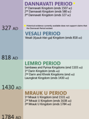
The natives of Arakan trace their history as far back as 2666 B.C., and give a lineal succession of 227 native princes down to modern times. According to them, their empire had at one period far wider limits, and extended over Ava, part of China, and a portion of Bengal. This extension of their empire is not, however, corroborated by known facts in history. According to recorded history, a kingdom called Dhanyawadi arose in the Arakan region in the 1st century AD. The famous Mahamuni Buddha (located in Mandalay) was cast in Dhanyawady in around 150 AD. The kingdom of Waithali (Rakhine: Wai-tha-li) was the successor to Dhanyawady from the 3rd century AD.
Arakan reached the zenith of its power in the Bay of Bengal during the Waithali (Vesali), Lemro and Mrauk U periods, but the country steadily declined from the seventeenth century onwards. Chittagong, which was part of Arakan, was invaded and occupied by the Mughal Empire in 1666. Internal instability and dethroning of kings was very common. The Portuguese, during the era of their greatness in Asia, gained a temporary establishment in Arakan; but on December 28th 1784 the province was finally conquered by the Burmese.
The famous Mahamuni Buddha image was taken as a war trophy by Crown Prince Shwedaung, son of King Bodawphaya and Conqueror of Arakan in 1784, to his capital of Amarapura. (The image was relocated to Mandalay By King Mindon in 1853 when he relocated the capital to Mandalay). The Burmese, after conquering Arakan, came directly into contact with British interests in east India. Burmese seizures of Arakan's neighbouring states of Assam and Manipur and the assault on Shinmaphyu Isle, which was a British outpost in Bengal was the instigating causes of the First Anglo-Burmese War (1824 to 26). Under the Treaty of Yandabo (1826), Burma ceded Arakan and Tenasserim to British India. Arakan was thus one of the first Burmese territories to be ceded to the British. The British made Akyab capital of Arakan, and retained the traditional divisions of the country into the districts of Akyab, Kyaukpyu and Sandoway (Ramree) with a district officer in charge of each. Akyab district originally included the Arakan Hill Tracts, which were detached 1865 and made into a separate district (and which is now Chin State).
With independence and the formation of the Union of Burma (now Myanmar) in 1948, the three districts became Arakan Division, on equal footing with the majority Burmese administrative divisions.
From the 1950s, there was a growing movement for secession and restoration of Rakhine independence. In part to appease this sentiment, in 1974, the Burmese government of Ne Win constituted Rakhine State from Arakan Division giving at least nominal acknowledgment of the majority Rakhine ethnic group.
See also
- List of Arakan Kings
References
This article incorporates text from the Encyclopædia Britannica Eleventh Edition, a publication now in the public domain.
External links
Rakhine independence-affiliated
|
||||||||||