Pytheas
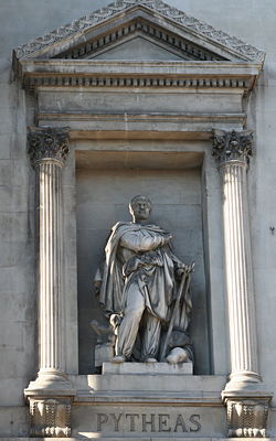
Statue of Pytheas outside of the Marseille Bourse.
|
Pytheas of Massilia (Ancient Greek Πυθέας ὁ Μασσαλιώτης), 4th century BC, was a Greek geographer and explorer from the Greek colony, Massilia (today Marseille, France). He made a voyage of exploration to northwestern Europe at about 325 BC. He travelled around and visited a considerable part of Great Britain. Some of his observations may refer to Stonehenge, the earliest report (if true). Pytheas is the first person on record to describe the Midnight Sun,[1] polar ice, the first to mention the name Britannia[2] and Germanic tribes and the one who introduced the idea of distant "Thule" to the geographic imagination. His account is the earliest to state that the moon is the cause of the tides.
Dates
Pliny says that Timaeus (born about 350 BC) believed Pytheas' story of the discovery of amber.[3] Strabo says that Dicaearchus (died about 285 BC) did not trust the stories of Pytheas.[4] That is all the information that survives concerning the date of Pytheas' voyage. Presuming that Timaeus would not have written until after he was 20 years old at about 330 BC and Dicaearchus would have needed time to write his most mature work, after 300 BC, there is no reason not to accept Tozer's window of 330 BC – 300 BC for the voyage.[5] Some would give Timaeus an extra 5 years, bringing the voyage down to 325 BC at earliest. There is no further evidence.
If one presumes that Pytheas would not have written prior to being 20 years old, he would have been a contemporary and competitor of Timaeus and Dicaearchus. As they read his writings he must have written toward the earlier years of the window.
Record

Pytheas described his travels in a work that has not survived; only excerpts remain, quoted or paraphrased by later authors, most familiarly in Strabo's Geographica,[6] Pliny's Natural History and passages in Diodorus of Sicily's history. Most of the ancients, including the first two just mentioned, refer to his work by his name: "Pytheas says ...." Two late writers give titles: the astronomical author, Geminus of Rhodes, mentions τὰ περὶ τοῦ Ὠκεανοῦ (ta peri tou Okeanou), literally "things about the Ocean", sometimes translated as "Description of the Ocean", "On the Ocean" or "Ocean;" Marcianus, the scholiast on Apollonius of Rhodes, mentions a περίοδος γῆς (periodos gēs), a "trip around the earth" or περίπλους (periplous), "sail around."
Scholars of the 19th century tended to interpret these titles as the names of distinct works covering separate voyages; for example, Smith's Dictionary of Greek and Roman Biography and Mythology[7] hypothesizes a voyage to Britain and Thule written about in "Ocean" and another from Cadiz to the Don river, written about in "Sail Around." As is common with ancient texts, multiple titles may represent a single source, for example, if a title refers to a section rather than the whole. The mainstream today recognizes periplus as a genre of navigational literature and concedes that there was only one work, "on the Ocean," which was based on a periplus.
Diodorus does not mention Pytheas by name. The connection is made as follows:[8] Pliny reports[9] that "Timaeus says there is an island named Mictis ... where tin is found, and to which the Britains cross...." Diodorus says that tin is brought to the island of Ictis, where there is an emporium. The last link is supplied by Strabo[10], who says that an emporium on the island of Corbulo in the mouth of the Loire was associated with the Britain of Pytheas by Polybius. Assuming that Ictis, Mictis and Corbulo are the same, Diodorus appears to have read Timaeus, who must have read Pytheas, whom Polybius also read. An implication is that Strabo did not read Pytheas, or he would not have had to resort to Polybius.
Circumstances of the voyage
Pytheas was not the first Mediterranean mariner to reach the British Isles. The Massaliote Periplus is a more extensive fragment preserved in paraphrase in the Ora Maritima, a poem of the 4th century AD written by the Roman, Avienus. This periplus of a ship from Marseille on which the poem relies is uncertain in date, but is believed to be possibly from the 6th century BC, not long after the founding of the city. It primarily describes the coasts of southern Spain and Portugal, but makes brief mention of a visit to "the sacred isle" (Ireland, Ierne) located across from Albion (an early name for Britain).
The start of Pytheas's voyage is unknown. The Carthaginians had closed the Strait of Gibraltar to all ships from other nations. Some historians, mainly of the late 19th century and before, therefore speculated (on no evidence) that he traveled overland to the mouth of the Loire or the Garonne. Others believed that, to avoid the Carthaginian blockade, he may have stuck close to land and sailed only at night. It is also possible he took advantage of a temporary lapse in the blockade.[11]
Detailed scholarship of the 20th century superseded these early views. By the 4th century BC the western Greeks, especially the Massilotes, were on amicable terms with Carthage. First, Massilia was militarily superior to Carthage. It had defeated the empire in the late 6th century BC and again in 490; not caring to test the issue any further, Carthage had made an early independent treaty with Massilia. The latter city had no trouble placing and keeping colonies on the coast of Spain. Archaeologically the sites of the western Mediterranean show no diminishment of Greek pottery at any time (a good indication of trade). It coexisted with Carthaginian artifacts.
Second, Massilia was a close ally of Rome even before the Roman republic, according to Gnaeus Pompeius Trogus. Massilia helped Rome defeat Veii in 396 BC and when Rome was sacked by the Gauls in 390 BC the Massiliotes took up a subscription to buy its freedom. Massiliotes sat in the closed sessions of the Roman Senate.
In 348 BC Carthage and Rome came to terms over the Sicilian Wars making a treaty defining their mutual interests. Rome could use Sicilian markets and Carthage could buy and sell at Rome. Slaves taken by Carthaginians from allies of Rome were to be set free. Rome was to stay out of the western Mediterranean, but these terms did not apply to Massilia, which had its own treaty. During the last half of the 4th century BC, the time of Pytheas' voyage, relations between Rome and its allies and the Carthaginian empire were completely amicable. Massiliotes were free to operate as they pleased. Certainly, there is no evidence of a Carthaginian problem in any of the sources concerning the voyage.[12]
The early part of Pytheas' voyage is outlined by statements of Eratosthenes that Strabo says are false because taken from Pytheas.[13] Apparently Pytheas said that tides ended at the "sacred promontory" (Ieron akrōtērion), meaning Sagres Point. From there to Gades is said to be 5 days' sail. Quibbling about this distance Strabo complains about Pytheas' portrayal of the exact location of Tartessos. Mention of these places in a journal of the voyage indicates Pytheas passed through the Straits of Gibraltar and sailed north along the coast of Portugal.
Discovery of Britain

Strabo reports that Pytheas says he "travelled over the whole of Britain that was accessible."[15] The word epelthein, at root "come upon", does not mean by any specific method, and Pytheas does not elaborate. He does use the word "whole" and he states a perimetron ("perimeter") of more than 40000 stadia. Using Herodotus' standard of 600 feet for one stadium obtains 4545 miles; however, there is no way to tell which standard foot was in effect. The English foot is an approximation. Strabo wants to discredit Pytheas on the grounds that 40000 stadia is outrageously high and cannot be real.
Diodorus Siculus gives a similar number:[16] 42500 stadia (about 4830 miles) and explains that it is the perimeter of a triangle around Britain, which is roughly triangular in shape. The consensus has been that he probably took his information from Pytheas through Timaeaus. Pliny gives the circuitus reported by Pytheas as 4875 Roman miles.[17]
The explorer, Fridtjof Nansen, in an article on the topic[18] explains this apparent fantasy of Pytheas as a mistake of Timaeus. Strabo (and Diodorus Siculus) never saw Pytheas' work (says Nansen), but they and others read of him in Timaeus. Pytheas reported only days' sail. Timaeus converted days to stadia at the rate of 1000 per day, a standard figure of the times. However, Pytheas only sailed 560 stadia per day for a total of 23800, which in Nansen's view is consistent with 700 stadia per degree. Nansen goes on to point out that Pytheas must have stopped to obtain astronomical data; presumably, the extra time was spent ashore. Using the stadia of Diodorus Siculus, one obtains 42.5 days for the time that would be spent in circumnavigating Britain. (It may have been a virtual circumnavigation; see under Thule below.)
The ancient perimeter according to Nansen based on the 23800 was 2375 miles. This number is in the neighborhood of what a triangular perimeter ought to be but it cannot be verified against anything Pytheas may have said nor is Diodorus Siculus very precise about the locations of the legs. The "perimeter" is often translated as "coastline" but this translation is misleading. The coastline, following all the bays and inlets, is 12,429 kilometres (7,723 mi) (see Geography of the United Kingdom). Pytheas could have travelled any perimeter between that number and Diodorus'. Polybius adds that Pytheas said he traversed the whole of Britain on foot,[19] of which he, Polybius, is skeptical. Despite Strabo's conviction of a lie, the perimeter said to have been given by Pytheas is not evidence of it. The issue of what he did say can never be settled until more fragments of Pytheas turn up.
Name and description of the British
| History of the British Isles
|
|
By chronology
By country
By topic
|

For "Britain" Pytheas through Strabo uses Bretannikē as a feminine noun, although its form is that of an adjective: "the Britannic." Pliny uses Britannia, with Britanniae meaning all the islands, "the Britains." Diodorus has Brettanikē nēsos, "the British Island", and Brettanoi, "the British." Ptolemy has Bretania and Bretanikai nēsoi.
On the surface it would appear that Pytheas was the first to use the name, Britannia; however, manuscript variants offer a P- alternating with B- and there is good reason for thinking that the name learned by Pytheas had P-, as in *Pretania or *Pritannia, etc.: the etymology of "Britain" is so convincing that many authors use the P-form, going to far as the quote the Greek or Latin with P-, even though it is predominantly B-. They attribute the B- to replacement by the Romans in the time of Julius Caesar.[20]

"Britain" is most like Welsh Ynys Prydein, "the island of Britain", in which is a P-Celtic allophone of Q-Celtic Cruithne in Irish Cruithen-tuath, "land of the Picts." The base word is Scottish/Irish cruth, Welsh pryd, "form." The British were the "people of forms", referring to their tattoos. The Roman word Picti, "the Picts", means "painted."
This etymology if correct suggests that Pytheas never visited Ireland or talked to the Irish, as they used the Q-Celtic, but Pytheas brought back the P-Celtic form. Furthermore, some Welsh ancestral language was spoken over all of Britain and Celtic was already divided.
Diodorus based on Pytheas[21] reports that Britain is cold and subject to frosts, being "too much subject to the bear" (and not "under the Arctic pole" as some translations say). This report suggests that Pytheas was there in the early Spring, as he encountered frosts but not blizzards, drifts and frozen bodies of water.

The numerous population of natives, he says, live in thatched cottages, store their grain in subterranean caches and bake bread from it. They are "of simple manners" (ēthesin haplous) and are content with plain fare. They are ruled by many kings and princes who live in peace with each other. Their troops fight from chariots, as did the Greeks in the Trojan War. Until Caesar they were never beaten and never invaded.
The tin trade
Opposite Europe in Diodorus is the promontory (akrōtērion) of Kantion (Kent), 100 stadia (several miles) from the land, but the text is ambiguous; the land could be either Britain or the continent. Beyond by four days' sail is another promontory, Belerion, which can only be Cornwall, as Diodorus is describing the triangular perimeter and the third point is Orkas, presumably the main island of the Orkney Islands.
The inhabitants of Cornwall are involved in the manufacture of tin ingots. They mine the ore, smelt it, beat it into cubes and transport it to Ictis by wagon, which they can do at low tide. Merchants purchasing it there pack it on horses for 30 days to the Rhone river, where it is carried down to the mouth. Diodorus says that the British in Cornwall because of the tin trade are more hospitable to strangers.
Observation of Stonehenge
A second passage from Diodorus has gained some repute as a possible report of Pytheas' observation of the monuments at Stonehenge.[22] The passage is distinctive for its unusual definition of the Hyperboreans as they who "lie beyond the breezes of the north wind", in contradistinction to the classical Roman definition as dweller in the far north, meaning northeastern Europe. Diodorus' Hyperboreans live on "an island in the Ocean over against Gaul, (as big as Sicily) ...", which can only be Britain. It is not called Britain but remains unnamed. One explanation for these variants is that the passage is from a different tradition than the classical names and definitions of Britain and the Hyperboreans. The latter's definition was given by Herodotus based on continental knowledge.[23]
Diodorus says that for this information he was relying on "Hecateus and some others" meaning Hecataeus of Abdera's On the Hyperboreans, now lost (based on the date of calendar he references). Hecataeus was a contemporary of Pytheas writing toward the end of the 4th century BC. As far as can be known now he might have had the Massiliote Periplus in front of him but his most likely source is same as everyone else's of the times, Pytheas of Massilia. Nothing in the passage or elsewhere, however, connects it directly to Pytheas.
On this island is "a stately grove and renowned temple, of a round form ... a city likewise consecrated to the god (Apollo), whose citizens ... play on the harp, chant sacred hymns to Apollo in the temple ...." The city is of international repute, being, says Diodorus, the native city of the famed Hyperborean necromancer, Abaris, who went with his arrow around the world without eating.[24] Over this city rule the Boread family, the descendants of Boreas.
On the surface the worship of the god appears to be equivocal. Apollo is a solar deity, but he returns to the temple every 19 years, about the time it takes for the plane of the moon's orbit to precess over a full circle. (More exactly 18.6 years; see under Month.) Moreover the passage stresses that from this island the moon is very close to the Earth so that all its topographical features can be seen (which some say gave Pytheas that idea that the moon controls the tides). Apparently the deity is lunar[25] and the temple must be at some location where lunar deities are worshipped.
However, the Metonic calendar introduced at Athens in 432 BC is based on the Metonic cycle, in which 19 solar years comes within two hours of coinciding with 235 months. There is no reason to favor the moon. (Reference to the Metonic cycle dates the passage to after the 5th century BC, excluding Hecataeus of Miletus from being Diodorus' Hecataeus.) In later times Borvo, a god of healing, was the Celtic equivalent of Apollo.[26] Other locations such as in Scandinavia have been proposed but according to the passage on this island the soil is so fertile as to produce two crops a year and the climate is temperate. Southern Britain better fits this description.
In the Iron age Stonehenge was a renewed center of power, the best candidate for the location of the city being the mound at nearby Vespasian's Camp (not a Roman castra nor in any way associated with Vespasian), which is arrow-shaped. If Pytheas did wander over the island he could hardly have avoided it. Diodorus (or Pytheas) says that these Hyperboreans had a distinct language and were friendly to Greeks.
Discovery of Thule

Strabo relates,[27] taking his text from Polybius, "Pytheas asserts that he explored in person the whole northern region of Europe as far as the ends of the world." Strabo does not believe it but he explains what Pytheas means by the ends of the world.[28] Thoulē, he says (modern Thule)[29] is the most northerly of the British Isles. There the circle of the summer tropic is the same as the Arctic Circle (see below on Arctic Circle). Moreover, says Strabo, none of the other authors (of his time) mention Thule, a fact which he uses to discredit Pytheas, but which to moderns indicates Pytheas was the first explorer to arrive there and tell of it.
Thule is described as an island of six days' sailing north of Britain, near the frozen sea (pepēguia thalatta, "solidified sea").[30] Pliny adds that it has no nights at midsummer when the sun is passing through the sign of the crab (summer solstice),[9] a reaffirmation that it is on the Arctic Circle. He adds that the crossing to Thule starts at the island of Berrice, "the largest of all", which may be Lewis in the outer Hebrides. If Berrice was in the outer Hebrides, the crossing would have brought Pytheas to the vicinity of Trondheim, Norway, explaining how he managed to miss the Skagerrak. If this is his route in all likelihood he did not actually circumnavigate Britain, but returned along the coast of Germany, accounting for his somewhat larger perimeter. His investigations amounted to a virtual cicumnavigation.
Concerning the location of Thule a discrepancy in data caused subsequent geographers some problems and may be responsible for Ptolemy's distortion of Scotland. Strabo reports[30] that Eratosthenes places Thule at a parallel 11500 stadia (16.4°) north of the mouth of the Borysthenes. The parallel running through that mouth also passes through Celtica and is Pytheas' base line. Using 3700 or 3800 stadia (5.3° or 5.4°) north of Marseille for a base line obtains a latitude of 64.8° or 64.9° for Thule, well short of the Arctic Circle. It is in fact the latitude of Trondheim, where Pytheas probably made land.
A statement by Geminus of Rhodes quotes On the Ocean as saying:[31]
... the Barbarians showed us the place where the sun goes to rest. For it was the case that in these parts the nights were very short, in some places two, in others three hours long, so that the sun rose again a short time after it had set.
Nansen[32] points out that according to this statement Pytheas was there in person and that the 21- and 22-hour days must be the customary statement of latitude by length of longest day. He calculates the latitudes to be 64° 32′ and 65° 31′, supporting Hipparchus' statement of the latitude of Thule. And yet Strabo says:[28]
Pytheas of Massilia tells us that Thule ... is farthest north, and that there the circle of the summer tropic is the same as the Arctic Circle.
Eratosthenes extends the latitudinal distance from Massilia to Celtica to 5000 stadia (7.1°), placing the base line in Normandy. The northernmost location cited in Britain at the Firth of Clyde is now northern Scotland. To get this country south of Britain to conform to Strabo's interpretation of Pytheas, Ptolemy has to rotate Scotland by 90°.
The 5000 stadia must be discounted: it crosses the Borysthenes upriver near Kiev rather than at the mouth.[33] It does place Pytheas on the Arctic Circle, which in Norway is just south of the Lofoten islands. On the surface it appears that Eratosthenes altered the base line to pass through the northern extreme of Celtica. Pytheas (as related by Hipparchus) probably cited the place in Celtica where he first made land. If he used the same practice in Norway, Thule is at least the entire northwest coast of Norway from Trondheim to the Lofoten Islands.
The explorer, Richard Francis Burton, in his study of Thule points out that it has had many definitions over the centuries. Many more authors have written about it than remembered Pytheas. The question of the location of Pytheas' Thule remains. The latitudes given by the ancient authers can be reconciled. The missing datum required to fix the location is longitude: "Manifestly we cannot rely upon the longitude."[34]
Pytheas crossed the waters northward from Berrice, in the north of the British Isles, but whether to starboard, larboard, or straight ahead is not known. From the time of the Roman Empire all the possibilites were suggested repeatedly by each generation of writers: Iceland, Shetland, the Faroe Islands, Norway and later Greenland. A manuscript variant of a name in Pliny has abetted the Iceland theory: Nerigon instead of Berrice, which sounds like Norway. If one sails west from Norway one encounters Iceland. Burton himself espoused this theory.
The standard texts have Berrice today, as well as Bergos for Vergos in the same list of islands. The Scandiae islands are more of a problem, as they could be Scandinavia, but other islands had that name as well. Moreover Procopius says[35] that the earlier name of Scandinavia was Thule and that it was the home of the Goths. Icelanders are fairly sure Iceland was not Thule, as Pytheas lived centuries before its colonization by European agriculturalists, and Greenland for the same reason is out of the question. The fact that Pytheas returned from the vicinity of the Baltic favors Procopius's view.
Concerning the people of Thule Strabo says of Pytheas (grudgingly):[36]
...he might possibly seem to have made adequate use of the facts as regards the people who live close to the frozen zone, when he says that, ... the people live on millet and other herbs, and on fruits and roots; and where there are grain and honey, the people get their beverage, also, from them. As for the grain, he says, – since they have no pure sunshine – they pound it out in large storehouses, after first gathering in the ears thither; for the threshing floors become useless because of this lack of sunshine and because of the rains.
What he seems to be describing is an agricultural country that uses barns for threshing grain rather than the Mediterranean outside floor of sun-baked mud and manufactures a drink, possibly mead.[37]
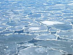
Encounter with drift ice
After mentioning the crossing (navigatio) from Berrice to Tyle Pliny makes a brief statement that:
A Tyle unius diei navigatione mare concretum a nonnullis Cronium appellatur.
"One day's sail from Thule is the frozen ocean, called by some the Cronian Sea."
The mare concretum appears to match Strabo's pepēguia thalatta and is probably the same as the topoi ("places") mentioned in Strabo's apparent description of spring drift ice, which would have stopped his voyage further north and was for him the ultimate limit of the world. Strabo[15] says:[38]
Pytheas also speaks of the waters around Thule and of those places where land properly speaking no longer exists, nor sea nor air, but a mixture of these things, like a "marine lung", in which it is said that earth and water and all things are in suspension as if this something was a link between all these elements, on which one can neither walk nor sail.
The term used for "marine lung" (pleumōn thalattios) appears to refer to jellyfish of the type the ancients called sea-lung. The latter are mentioned by Aristotle in On the Parts of Animals[39] as being free-floating and insensate. They are not further identifiable from what Aristotle says but some pulmones appear in Pliny[40] as a class of insensate sea animal; specifically the halipleumon ("salt-water lung").[41] William Ogle, Aristotle's translator and annotator, attributes the name sea-lung[42] to the lung-like expansion and contraction of the Medusae, a kind of Cnidaria, during locomotion. The ice resembled floating circles in the water. The modern term for this phenomenon is pancake ice.
The association of Pytheas' observations with drift ice has long been standard in navigational literature, including Bowditch, which begins Chapter 34, Ice in the Sea, with Pytheas.[43] At its edge sea, slush, and ice mix, surrounded by fog.
Discovery of the Baltic

Strabo says that Pytheas gave an account of "what is beyond the Rhine as far as Scythia", which he, Strabo, thinks is false.[44] In the geographers of the late Roman Republic and early Roman Empire, such as Ptolemy, Scythia stretches eastward from the mouth of the Vistula; thus Pytheas must have described the Germanic coast of the Baltic sea; if the statement is true, there are no other possibilities. As to whether he explored it in person, he said that he explored the entire north in person (see under Thule above). As the periplus was a sort of ship's log, he probably did reach the Vistula.
According to The Natural History" by Pliny the Elder:[3]
Pytheas says that the Gutones, a people of Germany, inhabit the shores of an estuary of the Ocean called Mentonomon, their territory extending a distance of six thousand stadia; that, at one day's sail from this territory, is the Isle of Abalus, upon the shores of which, amber is thrown up by the waves in spring, it being an excretion of the sea in a concrete form; as, also, that the inhabitants use this amber by way of fuel, and sell it to their neighbours, the Teutones.
The "Gutones" is a simplification of two manuscript variants, Guttonibus and Guionibus, which would be in the nominative case Guttones or Guiones, the Goths in the mainstream view.[45] The second major manuscript variant is either Mentonomon (nominative case) or Metuonidis (genitive case). A number of etymologies have been proposed but none very well accepted. Amber is not actually named. It is called the concreti maris purgamentum, "the leavings of the frozen sea" after the spring melt. Diodorus uses ēlektron, which became famous in modern times as electrum, the object that gave its name to electricity through its ability to acquire a charge. Pliny is presenting an archaic view, as in his time amber was a precious stone brought from the Baltic at great expense, but the Germans, he says, use it for firewood, according to Pytheas.
"Mentonomon" is unambiguously stated to be an aestuarium or "estuary" of 6000 stadia, which using the Herodotean standard of 600 feet per stadium is 681 miles. That number happens to be the distance from the mouth of the Skagerrak to the mouth of the Vistula, but no source says explicitly where the figure was taken. Competing views, however, usually have to reinterpet "estuary" to mean something other than an estuary, as the west of the Baltic Sea is the only body of estuarial water of sufficient length in the region.
Earlier[46] Pliny says that a large island of three days' sail from the Scythian coast called Balcia by Xenophon of Lampsacus is called Basilia by Pytheas. It is generally understood to be the same as Abalus. Based on the amber, the island could have been Helgoland, Zealand, the shores of Bay of Gdansk, Sambia or the Curonian Lagoon, which were historically the richest sources of amber in the North Europe, but the Teutones and Gutones of Pytheas' time inhabited only the south shores of the Baltic. This is the earliest use of Germania. The Latin text refers to the Goths as a gens Germaniae, a "people of Germany", and the Teutones are their proximi, "neighbors."
Voyage to the Don
Pytheas claimed to have explored the entire north; however, he turned back at the mouth of the Vistula, the border with Scythia. If he had gone on he would have discovered the ancestral Balts, who in classical times were considered Scythians. Polybius relates:[47] "... on his return thence (from the north), he traversed the whole of the coast of Europe from Gades to the Tanais." Some authors consider this leg a second voyage, as it does not seem likely he would pass by Marseille without refitting and refreshing the crew. It is striking that he encountered the border of Scythia, turned around, and went around Europe counter-clockwise until he came to the southern side of Scythia on the Black Sea. It is possible to speculate that he may have hoped to circumnavigate Europe, but the sources do not say. In other, even more speculative interpretations, Pytheas returned north and the Tanais is not the Don but is a northern river, such as the Elbe river.
Pytheas' measurements of latitude
Latitude by the altitude of the sun
In discussing the work of Pytheas, Strabo typically uses direct discourse: "Pytheas says ...." In presenting his astronomical observations, he changes to indirect discourse: "Hipparchus says that Pytheas says ...." either because he never read Pytheas' manuscript (because it was not available to him) or in deference to Hipparchus, who appears to have been the first to apply the Babylonian system of representing the sphere of the earth by 360°.[48]
Strabo uses the degrees, based on Hipparchus.[49] Neither say that Pytheas did. Nevertheless Pytheas did obtain latitudes, which, according to Strabo, he expressed in proportions of the gnōmōn ("index"), or trigonometric tangents of angles of elevation to celestial bodies. They were measured on the gnōmōn, the vertical leg of a right triangle, and the flat leg of the triangle. The imaginary hypotenuse looked along the line of sight to the celestial body or marked the edge of a shadow cast by the vertical leg on the horizontal leg.
Pytheas took the altitude of the sun at Massilia at noon on the longest day of the year and found that the tangent was the proportion of 120 (the length of the gnōmōn) to 1/5 less than 42 (the length of the shadow).[50] Hipparchus, relying on the authority of Pytheas (says Strabo[51]), states that the ratio is the same as for Byzantium and that the two therefore are on the same parallel. Nansen[52] and others prefer to give the cotangent 209/600, which is the inverse of the tangent, but the angle is greater than 45° and it is the tangent that Strabo states. His number system did not permit him to express it as a decimal but the tangent is about 2.87.
It is unlikely that any of the geographers could compute the arctangent, or angle of that tangent. Moderns look it up in a table. Hipparchos is said to have had a table of some angles. The altitude, or angle of elevation, is 70° 47’ 50″[52] but that is not the latitude.
At noon on the longest day the plane of longitude passing through Marseille is exactly on edge to the sun. If the Earth's axis were not tilted toward the sun, a vertical rod at the equator would have no shadow. A rod further north would have a north-south shadow, and as an elevation of 90° would be a zero latitude, the complement of the elevation gives the latitude. The sun is even higher in the sky due to the tilt. The angle added to the elevation by the tilt is known as the obliquity of the ecliptic and at that time was 23° 44′ 40″.[52] The complement of the elevation less the obliquity is 43° 13′, only 5′ in error from Marseille's latitude, 43° 18′.
Latitude by the elevation of the north pole
A second method of determining the latitude of the observer measures the angle of elevation of a celestial pole, north in the northern hemisphere. Seen from zero latitude the north pole's elevation is zero; that is, it is a point on the horizon. The declination of the observer's zenith also is zero and therefore so is his latitude.
As the observer's latitude increases (he travels north) so does the declination. The pole rises over the horizon by an angle of the same amount. The elevation at the terrestrial North Pole is 90° (straight up) and the celestial pole has a declination of the same value. The latitude also is 90.[53]
Moderns have Polaris to mark the approximate location of the North celestial pole, which it does nearly exactly, but this position of Polaris was not available in Pytheas' time, due to changes in the positions of the stars. Pytheas reported that the pole was an empty space at the corner of a quadrangle, the other three sides of which were marked by stars. Their identity has not survived but based on calculations these are believed to have been α and κ in Draco and β in Ursa Minor.[54]
Pytheas sailed northward with the intent of locating the Arctic Circle and exploring the "frigid zone" to the north of it at the extreme of the earth. He did not know the latitude of the circle in degrees. All he had to go by was the definition of the frigid zone as the latitudes north of the line where the celestial arctic circle was equal to the celestial Tropic of Cancer, the tropikos kuklos (refer to the next subsection). Strabo's angular report of this line as being at 24° may well be based on a tangent known to Pytheas, but he does not say that. In whatever mathematical form Pytheas knew the location, he could only have determined when he was there by taking periodic readings of the elevation of the pole (eksarma tou polou in Strabo and others).
Today the elevation can be obtained easily on ship with a quadrant. Electronic navigational systems have made even this simple measure unnecessary. Longitude was beyond Pytheas and his peers, but it was not of as great a consequence, because ships seldom strayed out of sight of land. East-west distance was matter of contention to the geographers; they are one of Strabo's most frequent topics. Because of the gnōmōn north-south distances were accurate often to within a degree.
It is unlikely that any gnōmōn could be read accurately on the pitching deck of a small vessel at night. Pytheas must have made frequent overnight stops to use his gnōmōn and talk to the natives, which would have required interpreters, probably acquired along the way. The few fragments that have survived indicate that this material was a significant part of the periplus, possibly kept as the ship's log. There is little hint of native hostility; the Celts and the Germans appear to have helped him, which suggests that the expedition was put forward as purely scientific. In any case all voyages required stops for food, water and repairs; the treatment of voyagers fell under the special "guest" ethic for visitors.
Location of the Arctic Circle
The ancient Greek view of the heavenly bodies on which their navigation was based was imported from Babylonia by the Ionian Greeks, who used it to become a seafaring nation of merchants and colonists during the Archaic period in Greece. Massilia was an Ionian colony. The first Ionian philosopher, Thales, was known for his ability to measure the distance of a ship at sea from a cliff by the very method Pytheas used to determine the latitude of Massilia, the trigonometric ratios.
The astronomic model on which ancient Greek navigation was based, which is still in place today, was already extant in the time of Pytheas, the concept of the degrees only being missing (if Hipparchus, who was after Pytheas, added those). The model[55] divided the universe into a celestial and an earthly sphere pierced by the same poles. Each of the spheres were divided into zones (zonai) by circles (kukloi) in planes at right angles to the poles. The zones of the celestial sphere repeated on a larger scale those of the terrestrial sphere.
The basis for division into zones was the two distinct paths of the heavenly bodies: that of the stars and that of the sun and moon. Astronomers know today that the Earth revolving around the sun is tilted on its axis, bringing each hemisphere now closer to the sun (summer) now further away (winter). The Greeks had the opposite model, that the stars and the sun rotated around the earth. The stars moved in fixed circles around the poles. The sun moved at an oblique angle to the circles, which obliquity brought it now to the north, now to the south. The circle of the sun was the ecliptic. It was the center of a band called the zodiac on which various constellations were located.
The shadow cast (or not cast) by a vertical rod at noon was the basis for defining zonation. The intersection of the northernmost or southernmost points of the ecliptic defined the axial circles passing through those points as the two tropics (tropikoi kukloi, "circles at the turning points") later named for the zodiacal constellations found there, Cancer and Capricorn. During noon of the summer solstice (therinē tropē) rods there cast no shadow.[56] The latitudes between the tropics were called the torrid zone (diakekaumenē, "burned up").
Based on their experience of the Torrid Zone south of Egypt and Libya (the Sahara desert) the Greek geographers judged it uninhabitable. Symmetry requires that there be an uninhabitable Frigid Zone (katepsugmenē, "frozen") to the north and reports from there since the time of Homer seemed to confirm it. The edge of the Frigid Zone ought to be as far south from the North Pole in latitude as the Summer Tropic is from the Equator. Strabo gives it as 24°, which may be based on a previous tangent of Pytheas, but he does not say. The Arctic Circle would then be at 66°, accurate to within a degree.[57]
Seen from the equator the celestial North Pole (boreios polos) is a point on the horizon. As the observer moves northward the pole rises and the circumpolar stars appear, now unblocked by the Earth. At the Tropic of Cancer the radius of the circumpolar stars reaches 24°. The edge stands on the horizon. The constellation of mikra arktos (Ursa Minor, "little bear") was (and approximately still is) entirely contained within the circumpolar region. The latitude was therefore called the arktikos kuklos, "circle of the bear." The terrestrial Arctic Circle was regarded as fixed at this latitude. The celestial Arctic Circle was regarded as identical to the circumference of the circumpolar stars and therefore a variable.
When the observer is on the terrestrial Arctic Circle and the radius of the circumpolar stars is 66° the celestial Arctic Circle is identical to the celestial Tropic of Cancer.[58] That is what Pytheas means when he says that Thule is located at the place where the Arctic Circle is identical to the Tropic of Cancer.[28] At that point, on the day of the Summer Solstice, the vertical rod of the gnōmōn casts a shadow extending in theory to the horizon over 360° as the sun does not set. Under the pole the Arctic Circle is identical to the Equator and the sun never sets but rises and falls on the horizon. The shadow of the gnōmōn winds perpetually around it.
Latitude by longest day and shortest solar elevation
Strabo uses the astronomical cubit (pēchus, the length of the forearm from the elbow to the tip of the little finger) as a measure of the elevation of the sun. The term "cubit" in this context is obscure; it has nothing to do with distance along either a straight line or an arc, does not apply to celestial distances, and has nothing to do with the gnōmōn. Hipparchus borrowed this term from Babylonia, where it meant 2°. They in turn took it from ancient Sumer so long ago that if the connection between cubits and degrees was known in either Babylonia or Ionia it did not survive. Strabo states degrees in either cubits or as a proportion of a great circle. The Greeks also used the length of day at the summer solstice as a measure of latitude. It is stated in equinoctial hours (hōrai isēmerinai), one being 1/12 of the time between sunrise and sunset on an equinox.
Based partly on data taken from Pytheas, Hipparchus correlated cubits of the sun's elevation at noon on the winter solstice, latitudes in hours of a day on the summer solstice, and distances between latitudes in stadia for some locations.[59] Pytheas had proved that Marseille and Byzantium were on the same parallel (see above). Hipparchus (through Strabo)[60] adds that Byzantium and the mouth of the Borysthenes (the Dnepr river) were on the same meridian and were separated by 3700 stadia (5.3° at Strabo's 700 stadia per degree). As the parallel through the river-mouth also crossed the coast of "Celtica", the distance due north from Marseille to Celtica was 3700 stadia, a baseline from which Pytheas seems to have calculated latitude and distance.[61]
Strabo says that Ierne (Ireland) is under 5000 stadia (7.1°) north of this line. These figures place Celtica around the mouth of the Loire river, an emporium for the trading of British tin. The part of Ireland referenced is the vicinity of Belfast. Pytheas then would either have have crossed the Bay of Biscay from the coast of Spain to the mouth of the Loire, or reached it along the coast, crossed the English channel from the vicinity of Brest, France to Cornwall, and traversed the Irish Sea to reach the Orkney Islands. A statement of Eratosthenes attributed by Strabo to Pytheas, that the north of Iberia was an easier passage to Celtica than across the Ocean,[62] is somewhat ambiguous: apparently he knew or knew of both routes, but he does not say which he took.
At noon on the winter solstice the sun stands at 9 cubits and the longest day on the summer solstice is 16 hours at the baseline through Celtica.[63] At 2500 stadia (3.6°) north of Celtica are a people Hipparchus called Celtic but Strabo thinks are the British, a discrepancy he might not have noted if he had known that the British were also Celtic. The location is Cornwall. The sun stands at 6 cubits and the longest day is 17 hours. At 9100 stadia north of Marseille (5400 or 7.7° north of Celtica) the elevation is 4 cubits and the longest day is 18 hours. This location is in the vicinity of the Firth of Clyde.
Here Strabo launches another quibble. Hipparchus, relying on Pytheas (says Strabo), places this area south of Britain, but he, Strabo, calculates that it is north of Ierne. Pytheas, however, rightly knows what is now Scotland as part of Britain, land of the Picts, even though north of Ierne. North of southern Scotland the longest day is 19 hours. Strabo, based on theory alone, states that Ierne is so cold[28] that any lands north of it must be uninhabited. In the hindsight given to moderns Pytheas in relying on observation in the field appears more scientific than Strabo, who discounted the findings of others merely because of their to him strangeness. The ultimate cause of his skepticism is simply that he did not believe Scandinavia could exist. This disbelief may also be the cause of alteration of Pytheas' data.
Pytheas on the tides
Pliny reports that "Pytheas of Massilia informs us, that in Britain the tide rises 80 cubits."[64] The passage does not give enough information to determine which cubit Pliny meant; however, any cubit gives the same general result. If he was reading an early source, the cubit may have been the Cyrenaic cubit, an early Greek cubit, of 463.1 mm, in which case the distance was 37 metres (120 ft). The maximum tidal rise in the Wash, where the tides are highest, is 6.8 metres (22 ft). One well-circulated but unevidenced answer is that Pytheas is referring to a storm tide.[5]
Matching fragments of Aëtius in pseudo-Plutarch and Stobaeus[65] attribute the flood tides (plēmmurai) to the "filling of the moon" (plērōsis tēs sēlēnēs) and the ebb tides (amplōtidai) to the "lessening" (meiōsis). The words are too ambiguous to make an exact determination of Pytheas' meaning, whether diurnal or spring and neap tides are meant, or whether full and new moons or the half-cycles in which they occur. Different translators take different views.
That daily tides should be caused by full moons and new moons is manifestly wrong, which would be a surprising view in a Greek astronomer and mathematician of the times. He could have meant that spring and neap tides were caused by new and full moons, which is partially correct in that spring tides occur at those times. A gravitational theory (objects fall to the center) existed at the time but Pytheas appears to have meant that the phases themselves were the causes (aitiai). However imperfect or imperfectly related the viewpoint, Pytheas was the first to associate the tides to the phases of the moon.
Literary influence
It is clear that Pytheas was a central source of information to later periods, and possibly the only source.[66]
Strabo, citing Polybius, accuses Pytheas of promulgating a fictitious journey he could never have funded, as he was a private individual (idiōtēs) and a poor man (penēs).[27] Markham[67] proposes a possible answer to the funding question: seeing that Pytheas was known as a professional geographer and that north Europe was as yet a question mark to Massilian merchants, he suggests that "the enterprise was a government expedition of which Pytheas was placed in command." In another suggestion the merchants of Marseille sent him out to find northern markets. These theories are speculative but perhaps less so than Strabo's contention that Pytheas was a charlatan just because a professional geographer.[68]
Strabo does explain his reasons for doubting Pytheas' veracity. Citing numerous instances of Pytheas apparently being far off the mark on details concening known regions, he says: "however, any man who has told such great falsehoods about the known regions would hardly, I imagine, be able to tell the truth about places that are not known to anybody."[44] As an example he mentions that Pytheas says Kent is several days' sail from Celtica when it is visible from Gaul across the channel. If Pytheas had visited the place he should have verified it personally.
The objection although partially true is itself flawed. Strabo interjects his own view of the location of Celtica, that it was opposite to Britain, end to end.[44] Pytheas, however, places it further south, around the mouth of the Loire (see above), from which it might justifiably be several days' sail.[69] The people across from Britain in Caesar are the Germani in the north and the Belgae (a mixture of Germans and Celts) in the south. Still, some of the Celtic lands were on the channel and were visible from it, which Pytheas should have mentioned but Strabo implies he did not.
Strabo's other objections are similarly flawed or else completely wrong. He simply did not believe the earth was inhabited north of Ierne. Pytheas however could not then answer for himself, or protect his own work from loss or alteration, so most of the questions concerning his voyage remain unresolved, to be worked over by every generation. To some he is a daring adventurer and discoverer;[70] to others, a semi-legendary blunderer or prevaricator.
The practice of attributing descriptions of the British and the Germans in Tacitus and other authors to Pytheas based on no evidence but their apparent antiquity has resulted in some extensive descriptions of the voyage and many more attributions of "first observation" than are justifiable. These descriptions have been presented as non-fiction or history. They may be the history of someone other than Pytheas but the synthesis into a single voyage of a single explorer whose work has been lost is fictional.
The logical outcome of this tendency is the historical novel with Pytheas as the main character and the celebration of Pytheas in poetry beginning as far back as Vergil. The process continues into modern times; for example, Pytheas is a key theme in Charles Olson's Maximus Poems.
Notes
- ↑ The theoretical existence of a Frigid Zone where the nights are very short in summer and the sun does not set at the summer solstice was already known. Similarly reports of a country of perpetual snows and darkness (the country of the Hyperboreans) had been reaching the Mediterranean for some centuries. Pytheas is the first known scientific visitor and reporter of the arctic.
- ↑ The islands may have been known previously as the Cassiterides, "Tin Islands", Markham (1898). Herodotus Book III.115 expresses scepticism concerning their existence, as he was never able to obtain an eyewitness, he says. Pytheas' work is the first in a chain of citations by later writers. His investigations are sometimes called the "discovery" of Britain in the sense of bringing to scientific attention a country only known to the Greek and Roman geographic community by rumor previously, parallel to the "discovery" of Africa by the British. Others such as the Phoenicians may have known the name and location but they guarded this type of trade information carefully.
- ↑ 3.0 3.1 Natural History Book 37, Chapter 11.
- ↑ Geographica Book II.4.2 (elsewhere paragraph 104).
- ↑ 5.0 5.1 Tozer (1897) page xxi.
- ↑ Book I.4.2-4 covers the astronomical calculations of Pytheas and calls him a prevaricator. Book II.3.5 excuses his prevarication on the grounds of his being a professional. Book III.2.11 and 4.4, Book IV.2.1 criticise him again, Book IV.4.1 mentions his reference to the Celtic Ostimi. Book IV.5.5 describes Thule. Book VII.3.1 accuses him of using his science to cover up lies.
- ↑ Under Pytheas.
- ↑ Holmes, T. Rice (1907). Ancient Britain and the Invasions of Julius Caesar. Oxford: Clarendon Press. pp. 499–500. Downloadable Google Books.
- ↑ 9.0 9.1 Natural History Book IV Chapter 30 (16.104).
- ↑ Geographica IV.2.1.
- ↑ Whitaker, Ian (December 1981 - January 1982). "The Problem of Pytheas' Thule" (html). The Classical Journal 77 (2): 148–164. http://www.jstor.org/pss/3296920. Retrieved on 2008-10-30. First page available no charge.
- ↑ Ebel, Charles (1976). Transalpine Gaul: The Emergence of a Roman Province. Leiden. pp. 9–15. ISBN 9004043845, ISBN 9789004043848.
- ↑ Geographica III.2.11.
- ↑ James J. Tierney; Ptolemy's Map of Scotland; The Journal of Hellenic Studies, Vol. 79, (1959), pp. 132-148
- ↑ 15.0 15.1 Geographica Book II.4.1.
- ↑ Book V chapter 21.
- ↑ Natural History Book IV Chapter 30 (16.102).
- ↑ Nansen, Fridtjof; Arthur G. Chater, Translator (1911). In Northern Mists: Arctic Exploration in Early Times"Volume I. New York: Frederick A. Stokes Co.. pp. 51. Downloadable Google Books
- ↑ Book XXXIV chapter 5, which survives as a fragment in Geographica Book II.4.1.
- ↑ Rhys, John (July and October 1891). "Certain National Names of the Aborigines of the British Isles: Sixth Rhind Lecture". The Scottish Review XVIII: 120–143. Downloadable Google Books.
- ↑ Siculi, Diodori; Peter Wesseling (Editor); L. Rhodoman; G. Heyn; N. Eyring (1798) (in Ancient Greek, Latin). Bibliothecae Historicae Libri Qui Supersunt: Nova Editio. Argentorati: Societas Bipontina. pp. 292–297. Downloadable Google Books. The location in Diodorus is Book V, Sections 21-22. The section numeration differs somewhat in different translations; the material is to be found near the end of Book V.
- ↑ Library Book II Chapter 3. Diodorus Siculus; G. Booth (Translator) (1814) (in English). The Historical Library of Diodorus the Sicilian. London: G.Booth, Military Chronicle Office. pp. 139. Downloadable Google Books
- ↑ Bridgman, Timothy P. (2005). Hyperboreans: Myth and History in Celtic-Hellenic Contacts. Routledge. pp. 135–137. ISBN 0415969786, ISBN 9780415969789. Bridgman refer to Histories IV.13.
- ↑ Herodotus, Histories, IV.35.
- ↑ Burl, Aubrey (2000). The Stone Circles of Britain, Ireland, and Brittany: New Revised Edition. Yale University Press. pp. 205. ISBN 0300083475, ISBN 9780300083477.
- ↑ Bridgman (2005) page 136.
- ↑ 27.0 27.1 Geographica II.4.2.
- ↑ 28.0 28.1 28.2 28.3 Geographica II.5.8.
- ↑ Pliny uses Tyle. Vergil references ultima Thule in Georgic I, Line 30, where the ultima refer to the ends of the world. Burton (1875) page 2.
- ↑ 30.0 30.1 Geographica I.4.2.
- ↑ Nansen page 53; Geminus, Introduction to the Phenomena, vi.9.
- ↑ Page 54.
- ↑ The mouth was further north than it is today; even so, 48.4° is up near Dnepropetrovsk. The Greeks must be allowed some inaccuracy for their measurements. In any case damming has changed the river a great deal and a few thousand years has been enough to change the courses of many rivers.
- ↑ Burton (1875) page 10.
- ↑ De Bello Gothico, Chapter 15.
- ↑ Geographica IV.5.5.
- ↑ Nelson points out that this passage in Strabo contains "ambiguity": he could mean either one drink made from grain and honey, in which case it would have to be mead unless one classified it as a combination of mead and beer, or two drinks, mead and beer. Strabo uses the singular pōma for "beverage" but the neuter singular does not exlude a type of which there are two specifics. Some mead also is and was made with hops and is strained briefly through grain (see mead) The issue remains. See Nelson, Max (2005). The Barbarian's Beverage: A History of Beer in Ancient Europe. Routledge. pp. 64. ISBN 0415311217, 9780415311212.
- ↑ Translation from Chevallier (1984).
- ↑ IV.5.
- ↑ Natural History IX.71.
- ↑ Natural History XXXII.53.
- ↑ Aristotle; William Ogle (1882). On the Parts of Animals. London: Kegan, Paul, French & Co.. pp. 226. Downloadable Google Books.
- ↑ Bowditch, Nathaniel (1995 Edition) (pdf). The American Practical Navigator: an Epitome of Navigation. Bethesda, Maryland: National Imagery and Mapping Agency. http://www.irbs.com/bowditch/pdf/chapt34.pdf. Retrieved on 2008-10-19.
- ↑ 44.0 44.1 44.2 Geographica I.4.3.
- ↑ Lehmann, Winfred P.; Helen-Jo J. Hewitt (1986). A Gothic Etymological Dictionary. Leiden: E.J. Brill. pp. 164. ISBN 9004081763, 9789004081765.
- ↑ Natural History IV.27.13 or IV.13.95 in the Loeb edition.
- ↑ XXXIV.5.
- ↑ Lewis, Michael Jonathan Taunton (2001). Surveying Instruments of Greece and Rome. Cambridge, New York: Cambridge University Press. pp. 26–27. ISBN 0521792975, 9780521792974.
- ↑ Geographica II.5.34: "If, then, we cut the greatest circle of the Earth into three hundred and sixty sections, each of these sections will have seven hundred stadia."
- ↑ Geographica II.5.41.
- ↑ II.1.12 and again in II.5.8.
- ↑ 52.0 52.1 52.2 Nansen (1911) page 46.
- ↑ Bowditch, Nathaniel (1995 Edition) (pdf). The American Practical Navigator: an Epitome of Navigation. Bethesda, Maryland: National Imagery and Mapping Agency. pp. 252. http://www.irbs.com/bowditch/pdf/chapt15.pdf. Retrieved on 2008-10-19. "That is, the altitude of the elevated pole is equal to the declination of the zenith, which is equal to the latitude".
- ↑ Hipparchos fragment from Commentary on the Phainomena of Aratos and Eudoxos, 1.4.1. Rihll, T.E.. "Astronomy" (htm). Greek and Roman Science and Technology V3 Note 14. Swansea University. Retrieved on 2008-09-25.
- ↑ Geographica II.5.3.
- ↑ Geographica II.5.7.
- ↑ Strabo's extensive presentation of the geographic model including the theory of the Arctic is to be found in Book II Chapter 5.
- ↑ Nansen (1911) page 53.
- ↑ Nansen (1911), page 52.
- ↑ Strabo II.1.12 – II.1.13.
- ↑ II.1.18 implies 3800, still attributed to Hipparchus. Eratosthenes has quite a different view. See under Thule.
- ↑ Strabo III.2.11.
- ↑ Strabo II.1.18. The notes of the Loeb Strabo summarize and explain this information.
- ↑ Natural History Book II Chapter 99
- ↑ Diels, Hermann (Editor) (1879) (in ancient Greek). Doxographi Graeci. Berlin: G. Reimer. pp. 383. Downloadable Google Books. Diels includes two matching fragments of Aetius' Placitia, one from Pseudo-Plutarch Epitome Book III Chapter 17 often included in Moralia and the other from Stobaeus' Extracta Book I Chapter 38 [33].
- ↑ The only ancient authors we know by name who saw Pytheas' text were Dicaearchus, Timaeus, Eratosthenes, Crates, Hipparchus, Polybius, Artemidorus and Posidonius, as Lionel Pearson remarked in reviewing Hans Joachim Mette, Pytheas von Massalia (Berlin: Gruyter) 1952, in Classical Philology 49.3 (July 1954), pp. 212-214.
- ↑ Markham (1898), page 510.
- ↑ Geographica II.3.5.
- ↑ Graham, Thomas H.B. (July to December 1893). "Thule and the Tin Islands". The Gentlemen's Magazine CCLXXV: 179. Downloadable Google Books.
- ↑ Sarton, Georg (1993). Ancient Science Through the Golden Age of Greece. New York: Courier Dover Publications. pp. 524–525. ISBN 0486274950, ISBN 9780486274959. "His fate was comparable to that of Marco Polo in later times; some of the things that they told were so extraordinary, so contrary to common experience, that wise and prudent men could not believe them and concluded they were fables".
Books and articles
Newer
- Chevallier, R. (December, 1984). "The Greco-Roman Conception of the North from Pytheas to Tacitus". Arctic 37 (4): 341–346.
- Cunliffe, Barry (2002). The Extraordinary Voyage of Pytheas the Greek: The Man Who Discovered Britain (Revised ed.). Walker & Co, Penguin. ISBN 0-8027-1393-9, ISBN 0-14-200254-2.
- Frye, John; Harriet Frye (1985). North to Thule: an imagined narrative of the famous "lost" sea voyage of Pytheas of Massalia in the fourth century B.C. Chapel Hill, NC: Algonquin Books of Chapel Hill. ISBN 0912697202, ISBN 9780912697208.
- Hawkes, C.F.C. (1977). Pytheas: Europe and the Greek Explorers. Oxford: Blackwell, Classics Department for the Board of Management of the Myres Memorial Fund. 090356307X.
- Roller, Duane W. (2006). Through the Pillars of Herakles: Greco-Roman Exploration of the Atlantic. London, New York: Routledge. ISBN 0415372879, 9780415372879.
- Roseman, Christina Horst (1994). Pytheas of Massilia: On the ocean: Text, translation and commentary. Ares Publishing. ISBN 0-89005-545-9.
- Stefansson, Vilhjalmur (1940). Ultima Thule: further mysteries of the Arctic. New York: Macmillan Co.
Older
- Burton, Richard F. (1875). Ultima Thule; or, A Summer in Iceland. London and Edinburgh: William P. Nimmo. Downloadable Google Books.
- Markham, Clements R. (June, 1898). "Pytheas, The Discoverer of Britain". The Geographical Journal (London: The Royal Geographical Society) 1 (6). Downloadable Google Books.
- Tozer, Henry Fanshawe (1897). History of Ancient Geography. Cambridge: University Press. Downloadable Google Books.
See also
- Britain (name)
- Mining in Cornwall
- Scythia
External links
- Darbyshire, Adrian (08 April 2008). "Pytheas visited the Isle of Man in 300 BC - claim" (html). Isle of Man Today. Retrieved on 2008-11-06.
- Engels, Andre. "Pytheas" (htm). Discoverer's Web. Technische Universiteit Eindhoven. Retrieved on 2008-09-20.
- Gill, N.S. (2008). "The Extraordinary Voyage of Pytheas the Greek, The Man Who Discovered Britain: Review of Barry Cunliffe's Account of Pytheas" (htm). about.com:Ancient/Classical History. Retrieved on 2008-09-20.
- "Pytheas". Encyclopedia Britannica. (1911). Love to Know. Retrieved on 2008-11-06.
- "The Northern Lights Route: The Voyage of Pytheas to Thule" (html). University Library of Tromsø (1999). Retrieved on 2008-11-05.
|
|||||||||||||||||||||||
|
||||||||||||||||||||