Pyrenees
| Pyrenees | |
| Spanish: Pirineos Catalan: Pirineus French: Pyrénées Occitan: Pirenèus Aragonese: Perinés Basque: Pirinioak |
|
| Range | |
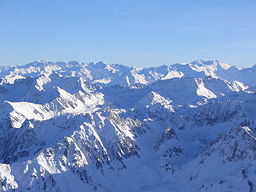 Central Pyrenees
|
|
| Named for: Pyrene | |
| Countries | Spain, France, Andorra |
|---|---|
| Highest point | Aneto |
| - elevation | 3,404 m (11,168 ft) |
| - coordinates | |
| Geology | granite, gneiss, limestone |
| Period | Paleozoic, Mesozoic |
 Topographic map (in French)
|
|

The Pyrenees (Spanish: Pirineos; French: Pyrénées; Catalan: Pirineus; Occitan: Pirenèus; Aragonese: Perinés; Basque: Pirinioak) are a range of mountains in southwest Europe that form a natural border between France and Spain. They separate the Iberian Peninsula from the rest of continental Europe, and extend for about 430 km (267 mi) from the Bay of Biscay (Cap Higuer) to the Mediterranean Sea (Cap de Creus).
For the most part, the main crest forms a massive divider between France and Spain, with the tiny country of Andorra sandwiched in between. Catalonia and the Basque Country are the human cultural regions that extend on both sides of the mountain range, with a northern and a southern part on each side[1][2].
According to the Greek mythology the Pyrenees are named after Pyrene (fire in Greek) the daughter of Bebryx who was supposedly raped by Herakles. Terrified by having given birth to a serpent, she fled to the mountains and was either buried or eaten by wild animals. Herodotus placed the setting of this mythological legend on his map of the Oikumene as early as 450 BC.
Contents |
Geography
Politically, the Spanish Pyrenees are part of the following provinces, from east to west: Girona, Barcelona, Lleida, Huesca, Navarra, and Guipúzcoa.
The French Pyrenees are also part of the following départements, from east to west: Pyrénées-Orientales, Aude, Ariège, Haute-Garonne, Hautes-Pyrénées, and Pyrénées-Atlantiques (the latter two of which include Pyrenees National Park).
The independent principality of Andorra is sandwiched in the eastern portion of the mountain range between the Spanish Pyrenees and French Pyrenees.

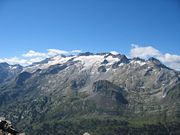
Physiograpically, the Pyrenees are typically divided into three sections: the Atlantic (or Western), the Central, and the Eastern Pyrenees. Together, they form a distinct physiographic province of the larger Alpine System division.
The Central Pyrenees extend westward from the Aran Valley to the Somport pass to the east, and they include the highest summits of this range:
- Pico d'Aneto or Pic de Néthou 3,404 metres (11,168 ft) in the Maladeta ridge,
- Posets peak 3,375 metres (11,073 ft),
- Mont Perdu or Monte Perdido or Mont Perdut 3,355 metres (11,007 ft).
In the Western Pyrenees the average elevation gradually increases from the west to the east, from the Basque mountains near the Bay of Biscay of the Atlantic Ocean. In the Eastern Pyrenees, with the exception of one break at the eastern extremity of the Pyrénées Ariégeoises, the mean elevation is maintained with remarkable uniformity until a sudden decline occurs in the portion of the chain known as the Albères.
Geology
The Pyrenees are older than the Alps: their sediments were first deposited in coastal basins during the Paleozoic and Mesozoic eras. Between 100 and 150 million years ago, during the Lower Cretaceous period, the Bay of Biscay fanned out, pushing present-day Spain against France and putting large layers of sediment in a vise grip. The intense pressure and uplifting of the Earth's crust first affected the eastern part and stretched progressively to the entire chain, culminating in the Eocene epoch.
The eastern part of the Pyrenees consists largely of granite and gneissose rocks, while in the western part the granite peaks are flanked by layers of limestone. The massive and unworn character of the chain comes from its abundance of granite, which is particularly resistant to erosion, as well as weak glacial development.
Landscape

Conspicuous features of Pyrenean scenery are:
- the absence of great lakes, such as those that fill the lateral valleys of the Alps
- the rarity and great elevation of passes
- the large number of the mountain torrents locally called gaves, which often form lofty waterfalls, surpassed in Europe only by those of Scandinavia
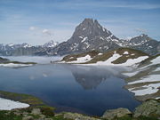
- the frequency with which the upper end of a valley assumes the form of a semicircle of precipitous cliffs, called a cirque.
The highest waterfall is that of Gavarnie (462 m or 1,515 ft), at the head of the Gave de Pau; the Cirque de Gavarnie, in the same valley, is perhaps the most famous example of the cirque formation. Low passes are lacking, and the principal roads and the railroads between France and Spain run only in the lowlands at the western and eastern ends of the Pyrenees, near sea level. Between the two ends of the range, the only two passes worth mentionings are the Col de la Perche, between the valley of the Têt and the valley of the Segre, and the Col de Somport or Port de Canfranc, where there were old Roman roads, but apparently, no modern highways.
A notable visual feature of this mountain range is La Brèche de Roland, a gap in the ridge line, which in legands was created by Roland.
Natural resources

The metallic ores of the Pyrenees are not in general of much importance now, though there were iron mines at Vie de Sos in Ariège and at the foot of Canigou in Pyrénées-Orientales long ago. Coal deposits capable of being profitably worked are situated chiefly on the Spanish slopes, but the French side has beds of lignite. The open pit of Trimoun (Ariège) is one of the greatest sources of talc in Europe.
Mineral springs are abundant and remarkable, and especially noteworthy are the hot springs, of which the Alps are very deficient. The hot springs, among which those of Panticosa, Lles, Bagnères-de-Luchon and Eaux-Chaudes may be mentioned, are sulphurous and mostly situated high, near the contact of the granite with the stratified rocks. The lower springs, such as those of Bagnères-de-Bigorre (Hautes-Pyrénées), Rennes-les-Bains (Aude) and Campagne (Aude), are mostly selenitic and not very warm.
Climate
The amount of the precipitation, including rain and snow, is much greater in the western than in the eastern Pyrenees, because of the moist air that blows in from the Atlantic Ocean over the Bay of Biscay. After dropping its moisture over the western and central Pyrenees, the air is usually dry over the eastern Pyrenees.
This all leads to a marked contrast between different sections of the mountain range in more than one respect. Some glaciers are found in the western and especially the snowy central Pyrenees, but the eastern Pyrenees are without any glaciers - with the quantity of snow falling there being insufficient to cause their development. The glaciers are confined to the northern slopes of the central Pyrenees, and do not descend, like those of the Alps, far down into the valleys, but have their greatest lengths along the direction of the mountain chain. They form, in fact, in a narrow zone near the crest of the highest mountains. Here, as in the other great mountain ranges of central Europe, there is great evidence of a much wider extension of the glaciers during the Ice Ages. The case of the glacier in the valley of Argelbs in the département of Hautes-Pyrénées is the best-known instance.
The snow-line varies in different parts of the Pyrenees from about 2,700 to 2,800 meters above sea-level.
Flora and fauna

A still more marked effect of the preponderance of rainfall in the western half of the chain is seen in the vegetation. The lower mountains in the extreme west are wooded, but the extent of forest declines eastwards, and the eastern Pyrenees are peculiarly wild and barren, all the more since it is in this part of the chain that granitic masses prevail. There is a change, moreover, in the composition of the flora in passing from west to east. In the west the flora resembles that of central Europe, while in the east it is distinctly Mediterranean in character, though the difference of latitude is only about 1°, on both sides of the chain from the centre whence the Corbières stretch north-eastwards towards the central plateau of France. The Pyrenees are relatively as rich in endemic species as the Alps, and among the most remarkable instances of that endemism is the occurrence of the monotypic genus Xatardia (family Apiaceae), only on a high alpine pass between the Val d'Eynes and Catalonia. The genus most abundantly represented in the range is that of the saxifrages, several species of which are endemic here.
The Pyrenean Ibex mysteriously became extinct in January 2000; the native Pyrenean brown bear was hunted to near-extinction in the 1990s, but it was re-introduced in 1996 when three bears were brought from Slovenia. The bear population has bred successfully, and there are now believed to be about 15 brown bears in the central region around Fos, but only four native ones are still living in Aspe valley.
In their fauna the Pyrenees present some striking instances of endemism. The Pyrenean Desman is found only in some of the streams of the northern slopes of these mountains, but the only other member of this genus are confined to the rivers of the Caucasus in southern Russia. The Pyrenean euprocte (Euproctus pyrenaicus), an endemic relative of the salamander, also lives in streams and lakes located at high altitudes. Among the other peculiarities of the Pyrenean fauna are blind insects in the caverns of Ariège, the principal genera of which are Anophthalmus and Adelops.
Protected areas

Principal nature reserves and national parks:
- Aigüestortes i Estany de Sant Maurici National Park (Spain)
- Ordesa y Monte Perdido National Park (Spain)
- Pyrénées National Park (France)
Demographics and culture
The ethnology, folklore, institutions and history of the Pyrenean region form an interesting study: see Andorra; Aragon; Ariege; Basque Country; Béarn; Catalonia; Navarre; Roussillon. For their history, see also Almogavars, Marca Hispanica.
Languages spoken in the area are, notably, Spanish, French, Catalan (in Catalonia and Andorra), and the Basque language. Also spoken, in a minor extent, are the Occitan language (the Gascon and Languedocien dialects in France and the Aranese dialect in the Aran Valley), and Aragonese.
Sports and Leisure
Both sides of the Pyrenees are popular spots for winter sports such as alpine skiing and mountaineering. The Pyreenees are also a good place for European and North African athletes to do high-altitude training in the summertime, such as by bicycling and cross-country running.
In the summer and the autumn, the Pyrenees are usually featured in two of cycling's epic grand tours, the Tour de France held annually in July and the Vuelta a España held in September. The stages held in the Pyrenees are often crucial legs of both tours, drawing hundreds of thousands of spectators to the region, too.
Three main long-distance footpaths run the length of the mountain range; the GR 10 across the northern slopes, the GR 11 across the southern slopes, and the HRP which traverses peaks and ridges along a high altitude route. In addition, there are numerous marked and unmarked trails throughout the region.
Pyrena is a dog-mushing competition held in the Pyrenees.
Ski resorts
Ski resorts in the Pyrenees include:

|
|
|
Highest summits

|
|
|
Noted Summits below 3,000 meters
|
|
|
References
- ↑ Preamble of the "Charter of the Catalan Language"
- ↑ Collins Road Atlas of Europe. London: Harper Collins. 1995. pp. 28–29. ISBN 0-00-448148-8.
Literature
- Paegelow, Claus (2008) (in German, English). Pyrenäen Bibliografie. Andorra, spanische & französische Pyrenäen, Pyrenees Bibliography. Andorra, Spain & French Pyrenees. Verlag Claus Paegelow. ISBN 978-3-00-023936-6.
See also
- Pre-Pyrenees
- Mountain passes of the Pyrenees
External links
- (English) Official website of France's Pyrenees National Park
- Bardenas Reales desert (Spain Pyrenees desert)
- Flying over the Pyrenees
- Great Routes: Pirineos, from a website of the Instituto de Turismo de España
- Complete guide to the Pyrenees Mountains
- Pyrenees Maps Interactive Google map with mountain tops in the Pyrenees.
- Glaciers of the Spanish Pyrenees
This article incorporates text from the Encyclopædia Britannica Eleventh Edition, a publication now in the public domain.
|
||||||||||||||||||||||
|
|||||||
