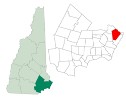
Portsmouth, New Hampshire
| Portsmouth, New Hampshire | |||
 |
|||
|
|||
 |
|||
| Coordinates: | |||
| Country | United States | ||
|---|---|---|---|
| State | New Hampshire | ||
| County | Rockingham | ||
| Incorporated | 1653 | ||
| Government | |||
| - Mayor | Tom Ferrini | ||
| - City manager | John P. Bohenko | ||
| Area | |||
| - Total | 16.8 sq mi (43.5 km²) | ||
| - Land | 15.6 sq mi (40.4 km²) | ||
| - Water | 1.2 sq mi (3.1 km²) 7.03% | ||
| Elevation | 20 ft (6 m) | ||
| Population (2000) | |||
| - Total | 20,784 | ||
| - Density | 1,331.3/sq mi (514.1/km²) | ||
| Time zone | Eastern (UTC-5) | ||
| - Summer (DST) | Eastern (UTC-4) | ||
| ZIP codes | 03801-03804 | ||
| Area code(s) | 603 | ||
| FIPS code | 33-62900 | ||
| GNIS feature ID | 0869312 | ||
| Website: www.cityofportsmouth.com | |||
Portsmouth is a city in Rockingham County, New Hampshire in the United States. It is the fourth-largest community in the county,[1] with a population of 20,784 at the 2000 census. A historic seaport and popular summer tourist destination, Portsmouth is served by Pease International Tradeport, a former military base converted into a civilian airport and office park.
Portsmouth was named one of the 2008 Dozen Distinctive Destinations by The National Trust for Historic Preservation.
Contents |
History

The first known European to explore and write about the area was Martin Pring in 1603. It would be settled in 1630 as Piscataqua, then given the name Strawbery Banke because of abundant wild strawberries growing beside the Piscataqua River, a tidal estuary with a swift current. Strategically located for trade between various upstream industries (particularly logging) and mercantile interests abroad, the port prospered. Fishing, lumber and shipbuilding were principal businesses.
At the town's incorporation in 1653, the name Portsmouth was adopted in honor of the colony's founder, John Mason. He had been captain of the port of Portsmouth, England, in the county of Hampshire, for which New Hampshire is named. In 1679, Portsmouth became the colonial capital. It also became a refuge for exiles from Puritan Massachusetts. When Queen Anne's War ended, the town was selected by Governor Joseph Dudley to host the 1713 Treaty of Portsmouth, which ended hostilities between Eastern Abenaki Indians and English settlements of the Province of Massachusetts Bay and New Hampshire.
During the Revolution, in 1774 Paul Revere rode to Portsmouth warning that the British were coming.[2] Although the harbor was protected by Fort William and Mary, the rebel government moved the capital inland to Exeter, particularly after Falmouth (now Portland, Maine) was bombarded by the Royal Navy on October 18, 1775. During President Thomas Jefferson's 1807 embargo, which withered trade, a number of local fortunes were lost. Others were gained by privateering during the War of 1812. In 1849, Portsmouth incorporated as a city.

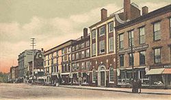
Once one of the nation's busiest ports and shipbuilding cities, Portsmouth's wealth was expressed in fine architecture. It contains significant examples of Colonial, Georgian, and Federal style houses, a selection of which are now museums. Portsmouth's heart contains stately brick Federalist stores and townhouses, built all-of-a-piece after devastating early 19th century fires, the worst being in 1813 when 244 buildings burned. A fire district was subsequently created which required that all new buildings within the district be constructed of brick with slate roofs. The city is also noted for producing boldly veneered Federalist furniture, particularly that by master cabinet maker Langley Boardman.
The Industrial Revolution, however, would leave Portsmouth in the shadow of New Hampshire mill towns like Dover, Keene, Laconia, Manchester, Nashua and Rochester. The effect of this economic shift was to preserve old Portsmouth throughout its Victorian doldrums, a time described in the works of native son Thomas Bailey Aldrich. Now, with the protection of a Historic District Commission, much of the city's architectural legacy survives -- to the delight of tourists and artists, who each summer throng the cafes around Market Square.
Portsmouth shipbuilding history has a long symbiotic relationship with Kittery, Maine, across the Piscataqua River. Although John Paul Jones boarded at the Portsmouth house which now bears his name, his ship Ranger was built on Badger's Island in Kittery. The Portsmouth Naval Shipyard, established in 1800 as the first federal navy yard, is located on Seavey's Island in Kittery. President Theodore Roosevelt arranged for the base to host negotiations leading to the 1905 Treaty of Portsmouth, ending the Russo-Japanese War.
Notable inhabitants

- Brooke Astor, socialite & philanthropist
- Ichabod Bartlett, congressman
- Al Barr, musician
- Samuel Cushman, congressman
- Ronnie James Dio, musician
- James T. Fields, publisher & author
- Betty Hill, UFO abductee
- Frank Jones, businessman, congressman & mayor
- John Paul Jones, "father" of U.S. Navy
- Jean Kasem, actress
- John Langdon, statesman & governor
- Tobias Lear, secretary to George Washington
- Daniel Marcy, congressman
- Jim McDermott, cartoonist & illustrator
- Fitz John Porter, general
- Tom Rush, musician
- Richard A. Searfoss, astronaut
- Benjamin Penhallow Shillaber, humorist
- Sir Benjamin Thompson, Count Rumford, physicist & inventor
- Daniel Webster, lawyer & statesman
- Benning Wentworth, royal governor
- Sir John Wentworth, last royal governor
- William Whipple, signer of Declaration of Independence
Geography
According to the United States Census Bureau, the city has a total area of 16.8 square miles (43.5 km2), of which 15.6 sq mi (40.4 km2) is land and 1.2 sq mi (3.1 km2) is water, comprising 7.03% of the town. Portsmouth is drained by Sagamore Creek and the Piscataqua River. The highest point in the city is 100 feet (30 m) above sea level, within Pease International Airport.
Demographics

As of the census[3] of 2000, there were 20,784 people, 9,875 households, and 4,858 families residing in the city. The population density was 1,331.3 people per square mile (514.1/km²). There were 10,186 housing units at an average density of 652.5/sq mi (251.9/km²). The racial makeup of the city was 93.55% White, 2.13% African American, 0.21% Native American, 2.44% Asian, 0.02% Pacific Islander, 0.28% from other races, and 1.36% from two or more races. Hispanic or Latino of any race were 1.35% of the population.
There were 9,875 households out of which 20.0% had children under the age of 18 living with them, 37.8% were married couples living together, 8.6% had a female householder with no husband present, and 50.8% were non-families. 38.9% of all households were made up of individuals and 11.5% had someone living alone who was 65 years of age or older. The average household size was 2.04 and the average family size was 2.75.

In the city the population was spread out with 17.2% under the age of 18, 7.2% from 18 to 24, 36.2% from 25 to 44, 23.2% from 45 to 64, and 16.3% who were 65 years of age or older. The median age was 38 years. For every 100 females there were 94.5 males. For every 100 females age 18 and over, there were 92.0 males.
The median income for a household in the city was $45,195, and the median income for a family was $59,630. Males had a median income of $41,966 versus $29,024 for females. The per capita income for the city was $27,540. About 6.4% of families and 9.3% of the population were below the poverty line, including 14.3% of those under age 18 and 8.4% of those age 65 or over.
Sites of interest
- Strawbery Banke - a neighborhood featuring several dozen restored historic homes in Colonial, Georgian and Federal styles of architecture. The site of one of Portsmouth's earliest settlements.
- The Music Hall (Portsmouth) - a 900-seat theater originally opened in 1878. After several closings, the theater is now run by a non-profit organization and currently under restoration. The venue hosts musical acts, theater, dance and cinema.
- USS Albacore Museum & Park - a museum featuring the USS Albacore, a U.S. Navy submarine used for testing that was decommissioned in 1972 and moved to the park in 1985. The submarine is open for tours.
- Portsmouth Harbor Lighthouse - First established in 1771, the current structure was built in 1878 and is open for monthly tours from May through September.
Historic house museums

- Jackson House (1664)
- John Paul Jones House (1758)
- Gov. John Langdon House (1784)
- Tobias Lear House (1740)
- Moffatt-Ladd House (1763)
- Rundlet-May House (1807)
- Warner House (1716)
- Wentworth-Coolidge Mansion (c. 1741)
- Wentworth-Gardner House (also called Wentworth House) (1760)
Sister cities

Portsmouth has five sister cities, as designated by Sister Cities International, Inc. (SCI):
 Carrickfergus, Northern Ireland, UK
 Nichinan, Japan
 Pärnu, Estonia
 Severodvinsk, Russia
 Szolnok, Hungary
Friendship city:
Education
- Hesser College
- Southern New Hampshire University - Portsmouth campus
- Franklin Pierce University - Portsmouth campus
Media
- The New Hampshire Gazette
- The Portsmouth Herald
- The Wire
- Radio
- WSCA-LP Portsmouth Community Radio 106.1 FM
- WHEB 100.3 FM rock formatted
- WMYF 1380 AM adult standards
Notes
- ↑ The Rockingham County towns (not cities) of Derry (34,021), Salem (28,112), and Londonderry (23,236) had greater populations as of the 2000 census.
- ↑ Paul Revere's Other Ride
- ↑ "American FactFinder". United States Census Bureau. Retrieved on 2008-01-31.
External links
- Portsmouth, NH Official Website
- Greater Portsmouth Chamber of Commerce
- Portsmouth Athenaeum
- Portsmouth Historic Cemetery Committee
- Portsmouth Historical Society
- Portsmouth Public Library
- New Hampshire Economic and Labor Market Information Bureau Profile
- Portsmouth, New Hampshire is at coordinates
|
|||||||||||||||||

|