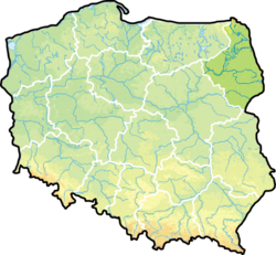
Podlaskie Voivodeship
| Podlaskie Voivodeship Województwo podlaskie |
|||
| — Voivodeship — | |||
|
|||
 |
|||
| Coordinates(Białystok): | |||
| Country | |||
|---|---|---|---|
| Capital | Białystok | ||
| Counties |
3 cities, 14 land counties *
|
||
| Area | |||
| - Total | 20,180 km² (7,791.5 sq mi) | ||
| Population (2006) | |||
| - Total | 1,197,610 | ||
| - Density | 59.3/km² (153.7/sq mi) | ||
| - Urban | 712,675 | ||
| - Rural | 484,935 | ||
| Car plates | B | ||
| * further divided into 118 gminas | |||
| Website: http://www.bialystok.uw.gov.pl | |||

Podlaskie Voivodeship (also known as Podlasie Province, Polish: województwo podlaskie [vɔjɛˈvut͡stfɔ pɔdˈlaskʲɛ] or simply Podlaskie) is a voivodeship (province) in north-eastern Poland. It was created on January 1, 1999, out of the former Białystok and Łomża Voivodeships and the eastern half of the former Suwałki Voivodeship, pursuant to the Local Government Reorganization Act of 1998.
Contents |
Etymology
The voivodeship takes its name from the historical region of Podlasie. This name originates from the period when the territory was within the Trakai Voivodeship of the Grand Duchy of Lithuania, along the borderline with the Mazovia province, primarily a fief of the Poland of the Piasts and later on part of the Kingdom of Poland of the Jagiellons. Hence pod Lachem would mean "near the Poles", "along the border with Poland". The historical Lithuanian name of the region, Palenkė, has exactly this meaning.
Geography
Natural assets
Podlaskie has the lowest population density of the sixteen Polish voivodeships, and its largely unspoilt nature is one of its chief assets. Around 30% of the area of the voivodeship is under legal protection. The Polish part of the Białowieża Forest biosphere reserve (also a World Heritage Site) is in Podlaskie. There are four National Parks (Białowieża, Biebrza, Narew and Wigry), three Landscape Parks (Knyszyn Forest, Łomża and Suwałki), 88 nature reserves, and 15 protected landscape areas. The voivodeship constitutes a part of the ecologically clean area known as "the Green Lungs of Poland".
Climate
Podlaskie is the coldest region of Poland, located in the very northeast of the country near the border with Belarus and Lithuania. The region has a continental climate which is characterized by high temperatures during summer and long and frosty winters . The climate is affected by the cold fronts which come from Scandinavia and Siberia. The average temperature in the winter ranges from -15°C (5°F) to -4°C (24.8°F).
| Month | Jan | Feb | Mar | Apr | May | Jun | Jul | Aug | Sep | Oct | Nov | Dec | Year |
|---|---|---|---|---|---|---|---|---|---|---|---|---|---|
| Average high °C (°F) | -3 (29) |
-3 (31) |
4 (40) |
11 (52) |
17 (63) |
20 (68) |
21 (70) |
21 (70) |
16 (61) |
11 (51) |
4 (39) |
1 (33) |
11 (51) |
| Average low °C (°F) | -6 (21) |
-6 (21) |
-2 (28) |
2 (35) |
7 (45) |
10 (50) |
12 (54) |
11 (52) |
8 (46) |
4 (39) |
0 (32) |
-4 (25) |
3 (37) |
| Source: Weatherbase[1] 2008-07-05 | |||||||||||||
Historical units
- For details about the history of the region, see Podlachia.
The following is a partial list of political subdivisions in which part or all of current day Podlaskie Voivodeship was wholly or partially contained within:
20th century
People's Republic of Poland / Third Polish Republic
- Białystok Voivodeship (1975-1998)
- Suwałki Voivodeship
- Łomża Voivodeship
- Białystok Voivodeship (1945-1975)
WW II
- Bezirk Bialystok (1941-1945)
- Belastok Voblast (1939-1945)
Second Polish Republic
- Białystok Voivodeship (1919-1939)
WW I
- Bialystok-Grodno District (1915-1919)
19th Century
Russian Empire
- Grodno Governorate (1842-1915)
- Belostok Oblast (1807-1842)
Kingdom of Poland (Congress Poland) Kingdom of Prussia
- Białystok Department (1795-1807)
16th-18th Century
Polish-Lithuanian Commonwealth
- Podlaskie Voivodeship (1569–1795)
12th-15th century
Grand Duchy of Lithuania
- Podlaskie Voivodeship (1513–1569)
- Trakai Voivodeship
- Duchy of Trakai
- Duchy of Lithuania
Kingdom of Poland
- Duchy of Masovia
Galicia-Volhynia
Early Middle Ages
- Yotvingia
Culture
Podlaskie is the most diverse of all Polish voivodships. The area has been inhabited for centuries by members of different nations and religions: Belarussians, Lithuanians, Ukrainians, Russyns, Gypsies, Tatars, Jews and Filipons).
Many places of religious worship remain:
- An eighteenth-century former Carmelite monastery on Wigry Lake
- A former jesuit monastery complex in Drohiczyn
- Christ’s Transfiguration Orthodox church on the Holy Mount of Grabarka
- Saint Nicolaus the Miracle Worker Orthodox church in Białystok
- A seventeenth-century synagogue in Tykocin
- The oldest Polish mosque in Kruszyniany
Sites of Historical Significance
Major monuments of the administrative region:
- Cathedral of St. Michael the Archangel and John the Baptist in Lomza (1504-1526)
- The ruins of a castle in Tykocin (XV century)
- Jewish cemetery in Tykocin (XVI century)
- Orthodox Annunciation of Our Lady in Supraślu (sixteenth to the eighteenth century)
- Dominican Monastery of the Visitation Church of the Assumption in Sejny (1610-1619)
- Old Parish Church in Bialystok (1617-1626)
- Synagogue (1642) and Dom Talmudyczny in Tykocin (eighteenth century)
- Carmelites Monastery with the church of Our Lady of Mount Caramel in Bielsk Podlaski (seventeenth century)
- Branicki Palace in Bialystok (the seventeenth and eighteenth centuries)
- Branicki summer residence in Choroszczy (1752-1759)
- Holy Trinity Church in Tykocin (1742-1750)
- Church of the Assumption in Siemiatyczach (1719-1727)
- Dominican Monastery of St. John the Baptist. & St. Stephen Martyr in Choroszczy (eighteenth century)
- Capuchin Monastery in Lomza (1770-1798)
- Old City Hall in Bielsk Podlaski
- Sokółki Palace in Pawłowiczch near Sokółka
- Orli Synagogue
- Bernardine monastery in Tykocin (1771-1791)
- Catholic Church. of the Nativity and St. Mary. and St. Nicholas in Bielsk Podlaski (1780)
- The Church of St. Nicholas in Bialystok (1843-1846)
- The Church of St. Anna in Kolnie (1834-1839)
- Cathedral of St. Aleksandra in Suwalki (1825)
- The Church of St. Anthony in Sokółka (1848)
- Cathedral Cemetery in Lomza
- Lubomirski Palace in Bialystok (the second half. Nineteenth century)
- Hasbacha Palace in Bialystok (end of the nineteenth century)
- The Palace and park in Buchholtzów Supraślu (1892-1903)
- Zespół fabryczny Beckera w Białymstoku (XIX/XX) Team name Becker in Bialystok (XIX / XX)
- Benedictine Monastery in Lomza (1863)
- Church of the Assumption in Lomza (1877)
- Holy Trinity Church in Zambrowie (1879)
- Holy Trinity Church in Grajewie (1882)
- The Church of St. John the Baptist in Wysokiem Mazowiecki (1888)
- Seminary in Lomza (1866)
- City Hall in Lomza (1822-23)
- Numerous monuments Street Dwornej in Lomza
- Manor in Wojnówce
- Basilica of the Assumption in Bialystok (1900-1905, neo-Gothic)
- The Church of St.Adalbert in Bialystok (1906-1912)
- The Church of St. Rocha in Bialystok (1926-1947, modernist)
- Church of the Sacred Heart of Jesus in Augustow (1905-1911 eclectic)
- The Church of Our Lady of Czestochowa and St. Casimir in Mońkach (1921-1935)
- Saints' Church of the Apostles Peter and Paul in Łapach (1918-1927)
- Fortress in Osowcu
- A Polish Tatars' (Islam_in_Poland) wooden mosque and a Muslim cemetery in the village of Bohoniki
Economy
According to REGON register in the year 2002 there were around 95 thousand companies registered in Podlasie region (97 % of them in private sector), dealing with;
- Trade and servicing – 33.2 %
- Providing services to real estates and companies – 11.8 %
- Construction – 10.5%
- Industrial processing – 9.7 %
- Transport 8.3%
- Agriculture, hunting and forestry 4.5%
Agriculture
Arable land constitutes around 60% of the total area of the region – most of which is ploughland (around 40%), forests, meadows and pastures. Over 120 000 farms are registered, roughly half of which are small farms of 1–5 ha and medium-sized farms of 5–10 ha. The smaller farms prefer intensive production (gardening, orcharding), whereas the larger ones engage in cattle and crop production. The cattle-raising farms are mainly oriented towards milk production.
The natural conditions of the region are conducive to the development of organic growing, which at present is practised by around 100 farms. Over 600 farms in the region offer agritourist services. [2]
Government
The voivodeship's seat is the city of Białystok. Like all voivodeships, it has a government-appointed Provincial Governor[3] (Polish: wojewoda), as well as an elected Regional Assembly (sejmik) and of the executive elected by that assembly, headed by the voivodeship marshal (marszałek województwa). Administrative powers and competences are statutorily divided between these authorities.
Cities and Towns
The voivodeship contains 36 cities and towns. These are listed below in descending order of population (according to official figures for 2006 [4]):
|
1. Białystok (295,210) |
13. Mońki (10,455) |
25. Lipsk (2,498) |
Administrative division
Podlaskie Voivodeship is divided into 17 counties (powiats): 3 city counties and 14 land counties. These are further divided into 118 gminas.
The counties are shown on the numbered map and detailed in the table beside it.

| English and Polish names |
Area (km²) |
Population (2006)[4] |
Seat | Other towns | Total gminas |
| City counties | |||||
| 102 | 295,210 | 1 | |||
| 65 | 69,234 | 1 | |||
| 33 | 63,572 | 1 | |||
| Land counties | |||||
| Białystok County powiat białostocki |
2,985 | 136,797 | Białystok * | Łapy, Czarna Białostocka, Wasilków, Choroszcz, Supraśl, Zabłudów, Tykocin, Suraż | 15 |
| Sokółka County powiat sokólski |
2,054 | 72,424 | Sokółka | Dąbrowa Białostocka, Suchowola | 10 |
| Bielsk County powiat bielski |
1,385 | 60,047 | Bielsk Podlaski | Brańsk | 8 |
| Wysokie Mazowieckie County powiat wysokomazowiecki |
1,288 | 59,719 | Wysokie Mazowieckie | Ciechanowiec | 10 |
| Augustów County powiat augustowski |
1,658 | 58,966 | Augustów | Lipsk | 7 |
| Łomża County powiat łomżyński |
1,354 | 50,887 | Łomża * | Nowogród, Jedwabne | 9 |
| Grajewo County powiat grajewski |
967 | 50,120 | Grajewo | Szczuczyn, Rajgród | 6 |
| Siemiatycze County powiat siemiatycki |
1,460 | 48,603 | Siemiatycze | Drohiczyn | 9 |
| Hajnówka County powiat hajnowski |
1,624 | 48,130 | Hajnówka | Kleszczele | 9 |
| Zambrów County powiat zambrowski |
733 | 44,798 | Zambrów | 5 | |
| Mońki County powiat moniecki |
1,382 | 42,960 | Mońki | Knyszyn, Goniądz | 7 |
| Kolno County powiat kolneński |
940 | 39,676 | Kolno | Stawiski | 6 |
| Suwałki County powiat suwalski |
1,307 | 35,136 | Suwałki * | 9 | |
| Sejny County powiat sejneński |
856 | 21,331 | Sejny | 5 | |
| * seat not part of the county | |||||
External links
- Radzilow Web Page
- Szczuczyn Web Page
- Wizna Web Page
- VisitBiałystok.com
- Podlaski Urząd Wojewódzki Official website
- Natural tourism (birdwatching) in Podlasie
- Topographical maps 1:50 000
References
- ↑ "Weatherbase: Historical Weather for Białystok, Poland" (in English). Retrieved on July, 2008.
- ↑ "Podlaski Urząd Wojewódzki - Podlasie Voivodship Office" (in Polish) (2007).
- ↑ "Ministry of Foreign Affairs (MFA) Agreement Article XI, Coordination with Polish Authorities" (in Polish) (2007-12-31).
- ↑ 4.0 4.1 "Central Statistical Office (GUS) Population: Size and Structure by Administrative Division" (in Polish) (2007-12-31).
|
||||||||||
|
|||||||