Plymouth
| Plymouth | |||
| — Unitary Authority — | |||
 |
|||
|
|||
| Nickname(s): Spirit of Discovery[1] | |||
| Motto: Turris fortissima est nomen Jehova "The name of Jehova is the strongest tower"[2] |
|||
 |
|||
| Coordinates: | |||
| Sovereign state | United Kingdom | ||
|---|---|---|---|
| Constituent country | England | ||
| Region | South West England | ||
| City status | 1928 | ||
| Unitary Authority | 1998 | ||
| Government | |||
| - Type | City Council | ||
| - Lord Mayor | Brian Vincent | ||
| - HQ | Civic Centre Precinct | ||
| - Wards | 20 | ||
| - UK Parliament | Plymouth Sutton South West Devon Plymouth Devonport |
||
| - European Parliament | South West England | ||
| Area | |||
| - Total | 30.6 sq mi (79.29 km²) | ||
| Highest elevation | 509 ft (155 m) | ||
| Lowest elevation | 0 ft (0 m) | ||
| Population (2007 est.) | |||
| - Total | 250,700 | ||
| - Density | 8,138/sq mi (3,142/km²) | ||
| - Demonyms | Plymothian (formal) Janner (informal) |
||
| - Ethnicity (2001)[3] |
98.35% White
|
||
| Time zone | GMT (UTC0) | ||
| - Summer (DST) | BST (UTC+1) | ||
| Postcode district | PL1 — 9 | ||
| Website: www.plymouth.gov.uk | |||
Plymouth (ˈplɪməθ) is a city and unitary authority area on the coast of Devon, England, about 190 miles (310 km) south west of London. It is built between the mouths of the rivers Plym and Tamar, where they join Plymouth Sound. Since 1967 the unitary authority of Plymouth has included the suburbs of Plympton and Plymstock, which are on the east side of the River Plym.
Plymouth's history goes back to the Bronze Age, when its first settlement grew at Mount Batten. This settlement continued to grow as a trading post for the Roman Empire, until the more prosperous village of Sutton, the current Plymouth, surpassed it. In 1620 the Pilgrim Fathers left Plymouth for the New World and established Plymouth Colony — the second English settlement in the United States of America. During the English Civil War the town was held by the Parliamentarians and was besieged between 1642 and 1646.
Throughout the Industrial Revolution Plymouth grew as a major shipping port, handling imports and passengers from the Americas and the construction of ships for the Royal Navy. This later led to its targeting and partial destruction during World War II, an act known as the Plymouth Blitz. After the war the city centre was completely rebuilt.
Today the city is home to over 250,000 people, making it the 15th most populous city in England. It has its own city council and is represented nationally by three MPs. Plymouth's economy is still strongly influenced by shipbuilding, but has become a more service-based economy since the 1990s. It has the 11th largest university in the United Kingdom, the University of Plymouth, and the largest operational naval base in Western Europe — HMNB Devonport. Plymouth has ferry links to France and Spain and an airport with international services.
Contents |
History
Early history
Upper Palaeolithic deposits, including bones of Homo sapiens, have been found in local caves,[4] and artifacts dating from the Bronze Age to the Middle Iron Age have been found at Mount Batten showing that it was one of the main trading ports of the country at that time.[5] The settlement of Plympton, further up the River Plym than the current Plymouth, was also an early trading port, but the river soon silted up and forced the mariners and merchants to settle at the current day Barbican near the river mouth.[6] At the time this village was called Sutton, meaning south town in Saxon.[6] The name Plymouth, meaning "mouth of the River Plym" — the river name being a back-formation from Plympton ("Plum-tree town"),[7] was first mentioned in a Pipe Roll of 1211.[8]
Early defence and Renaissance

During the Hundred Years' War a French attack (1340) burned a manor house and took some prisoners, but failed to get into the town.[9] In 1403 the town was burned by Breton raiders.[10] A series of fortifications were built in the Tudor and Elizabethan eras, which include the four round towers featured on the city coat of arms; the remains of two of these can still be found at Mount Batten and at Sutton Pool below the Royal Citadel.[11]
During the 16th century locally produced wool was the major export commodity.[12] Plymouth was the home port for successful maritime traders, among them Sir John Hawkins, who led England's first foray into the Atlantic slave trade,[13] as well as Sir Francis Drake.[14] According to legend, Drake insisted on completing his game of bowls on the Hoe before engaging the Spanish Armada in 1588.[14] In 1620 the Pilgrim Fathers set sail for the New World from Plymouth, establishing Plymouth Colony — the second English colony in the United States of America.[15]
During the English Civil War Plymouth sided with the Parliamentarians and was besieged for almost four years by the Royalists.[16] The last major attack by the Royalist was by Sir Richard Grenville leading thousands of soldiers towards Plymouth, but they were defeated by the Plymouthians.[16] The civil war ended as a Parliamentary win, but monarchy was restored by King Charles II in 1649, who imprisoned many of the Parliamentary heroes on Drake's Island.[16] Construction of the Royal Citadel began in 1665, after the Restoration; it was armed with cannon facing both out to sea and into the town, rumoured to be a reminder to residents not to oppose the Crown.[17]

Throughout the 17th century Plymouth had gradually lost its pre-eminence as a trading port. By the mid-1600s commodities manufactured elsewhere in England cost too much to transport to Plymouth and the city had no means of processing sugar or tobacco imports, although it played a relatively small part in the Atlantic slave trade during the early 1700s.[12] In 1690 the first dockyard, HMNB Devonport, opened on the banks of the Tamar and further docks were built in 1727, 1762 and 1793.[2] In the 18th century new houses were built near the dock, called Plymouth Dock at the time,[18] and a new town grew up. In 1712 there were 318 men employed and by 1733 it had grown to a population of 3,000 people.[6]
Prior to the latter half of the 18th century grain, timber and then coal were the greatest imports.[19] During this time the real source of wealth and the major employer in the region became the dockyard.[6] The Three Towns conurbation of Plymouth, Stonehouse and Devonport enjoyed some prosperity during the late 18th and early 19th century and were enriched by a series of neo-classical urban developments designed by London architect John Foulston.[20] Foulston was important for the town and was responsible for several grand public buildings, many now destroyed, including the Athenaeum, the Theatre Royal and Royal Hotel, and much of Union Street.[20] Some of the greatest imports to Plymouth from the Americas and Europe during the latter half of the 19th century included maize, wheat, barley, sugar cane, guano, sodium nitrate and phosphate.[21] Aside from the dockyard, other industries such as the gasworks, the railways and tramways and a number of small chemical works had begun to develop in the 19th century continuing into the 20th century.[22]
Twentieth Century

The city was heavily bombed by the Germans during World War II in a series of 59 raids known as the Plymouth Blitz.[22] Although the dockyards were the principal targets, much of the city centre and over 3,700 houses were completely destroyed and more than 1,000 civilians lost their lives.[23] The redevelopment of the city was planned by Sir Patrick Abercrombie in 1943[24] and by 1964 over 20,000 new homes had been built.[25] Most of the shops had been destroyed and those that remained were cleared to enable a zoned reconstruction according to his plan.[25] Charles Church was destroyed in 1941 during the Blitz, but has not been restored or demolished, as it is now an official permanent monument to the bombing of Plymouth during World War II.[26] Devonport Dockyard was kept busy refitting aircraft carriers such as the Ark Royal. By the time this work ended in the late 1970s the nuclear submarine base was operational. The army had substantially left the city by 1971, with barracks pulled down in the 1960s,[25] however the city has become home to the Royal Marines.[25]
Governance
Local government history

The first record of the existence of a settlement at Plymouth was in the Domesday Book in 1086 as Sudtone, Saxon for south farm, located at the present day Barbican.[2] In 1254 it gained status as a town and in 1439, became the first town in England to be granted a Charter by Parliament.[2] In 1914 the county boroughs of Plymouth and Devonport, and the urban district of East Stonehouse merged to form a single county borough of Plymouth.[6] Collectively they were referred to as "The Three Towns".[27] A provisional order was made on 2 May 1914, to come into effect in November.[28] Plymouth was granted city status on 18 October 1928.[29] The city's first Lord Mayor was appointed in 1935 and its boundaries further expanded in 1967 to include the town of Plympton and the parish of Plymstock.[6]
The 1971 Local Government White Paper proposed abolishing county boroughs, which would have left Plymouth, a town of 250,000 people, being administered from a council based at the smaller Exeter, on the other side of the county. This led to Plymouth lobbying for the creation of a Tamarside county, to include Plymouth, Torpoint, Saltash, and the rural hinterland.[30] The campaign was not successful, and Plymouth ceased to be a county borough on 1 April 1974 with responsibility for education, social services, highways and libraries transferred to Devon County Council. All powers returned when the city become a unitary authority on 1 April 1998 under recommendations of the Banham Commission.[31]
City Council

- See also: List of wards in Plymouth
The City of Plymouth is divided into 20 wards, 17 of which elect three councillors and the other three electing two councillors, making up a total council of 57.[33] Each year a third of the council is up for election for three consecutive years — there are no elections on the following "fourth" year, which is when County Council elections take place.[33] The total electorate for Plymouth was 183,358 in December 2007.[34] The local election of May 2008 resulted in a political composition of 37 Conservative and 20 Labour.[35] As of 2009 or 2010, the next general election, the constituencies of Devonport and Sutton will merge to become Plymouth Sutton and Devonport, whilst a new constituency, Plymouth Moor View, will be formed to the north of the city taking in wards from Devonport.[36]
Since 6 May 1935 Plymouth has been granted a Lord Mayor by the King on the recommendation of the Home Secretary, which is elected each year on the third Friday of May by a group of six people.[37] It is traditional that the position of the Lord Mayor alternates between the Conservative Party and the Labour Party annually and that the Lord Mayor chooses the Deputy Lord Mayor.[37] In Parliament, Plymouth is represented by the three constituencies of Plymouth Devonport, Plymouth Sutton and South West Devon.[38] As of the 2005 General Election, Devonport and Sutton are held by Labour MPs Alison Seabeck and Linda Gilroy, with South West Devon held by Conservative MP Gary Streeter.[38] The city is part of South West England and Gibraltar in the European parliament.[38] As of May 2008 and until May 2009 Brian Vincent holds the position of Lord Mayor for the Labour Party.[39]
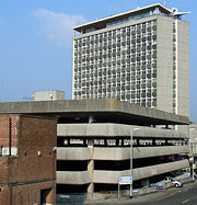
The Lord Mayor's official residence is 3 Elliot Terrace, located on the Hoe.[40] Once a home of Waldorf and Nancy Astor, it was given by Lady Astor to the City of Plymouth as an official residence for future Lord Mayors and is also used today for civic hospitality, as lodgings for visiting dignitaries and High Court judges and it is also available to hire for private events.[40] The Civic Centre municipal office building in Armada Way became a listed building in June 2007 because of its quality and period features, but has become the centre of a controversy as the council planned for its demolition estimating that it could cost £40m to refurbish it, resulting in possible jobs loses.[41]
Plymouth City Council is formally twinned with:[42]
 Brest, France (1963)
 Gdynia, Poland (1976)
 Novorossiysk, Russia (1990)
 San Sebastián, Spain (1990)
 Plymouth, Massachusetts United States (2001)
Geography
- See also: Places in Plymouth
| for Plymouth[43] | |||||||||||||||||||||||||||||||||||||||||||||||
|---|---|---|---|---|---|---|---|---|---|---|---|---|---|---|---|---|---|---|---|---|---|---|---|---|---|---|---|---|---|---|---|---|---|---|---|---|---|---|---|---|---|---|---|---|---|---|---|
| J | F | M | A | M | J | J | A | S | O | N | D | ||||||||||||||||||||||||||||||||||||
|
114
9
3
|
92
8
3
|
87
10
4
|
59
12
6
|
61
15
8
|
57
18
11
|
55
20
13
|
69
19
13
|
76
18
11
|
95
15
9
|
101
11
6
|
116
10
4
|
||||||||||||||||||||||||||||||||||||
| temperatures in °C precipitation totals in mm |
|||||||||||||||||||||||||||||||||||||||||||||||
|
Imperial conversion
|
|||||||||||||||||||||||||||||||||||||||||||||||
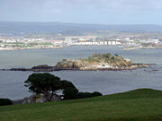
Plymouth lies between the River Plym to the east and the River Tamar to the west; both rivers flow into the natural harbour of Plymouth Sound.[44] The River Tamar forms the county boundary between Devon and Cornwall and its estuary forms the Hamoaze on which is sited Devonport Dockyard.[44] The River Plym, which flows off Dartmoor to the north east, forms a smaller estuary to the east of the city called Cattewater. Plymouth Sound is protected from the sea by the Plymouth Breakwater, in use since 1814.[45] In the Sound is Drake's Island which is seen from Plymouth Hoe, a flat public area on top of limestone cliffs.[46] The Unitary Authority of Plymouth is 30.8 square miles (79.78 km²),[47] but the city of Plymouth, as cited from Plymouth City Council, is 30.61 square miles (79.29 km²).[48] The topography rises from sea level to a height, at Roborough, of about 509 feet (155 m) above Ordnance Datum (AOD).[48]
The geology of Plymouth has a mixture of limestone, Devonian slate, granite and Middle Devonian limestone.[49] Plymouth Sound, Shores and Cliffs is a Site of Special Scientific Interest, because of its geology.[50] The bulk of the city is built upon Upper Devonian slates and shales and the headlands at the entrance to Plymouth Sound are formed of Lower Devonian slates, which can withstand the power of the sea.[49] A band of Middle Devonian limestone runs west to east from Cremyll to Plymstock including the Hoe.[49] Local limestone may be seen in numerous buildings, walls and pavements throughout Plymouth.[49] To the north and north east of the city is the granite mass of Dartmoor, which was mined and exported via Plymouth — rocks brought down river from Dartmoor has given rise to ores containing tin, copper, tungsten, lead and other minerals in the Tamar Valley.[49] There is evidence that the middle Devonian limestone belt in the south edge of Plymouth and in Plymstock was quarried at West Hoe, Cattedown and Radford.[51]
On 27 April 1944 Sir Patrick Abercrombie's Plan for Plymouth was published to rebuild the city calling for the destruction of the few remaining pre-War buildings in the city centre and their replacement with wide, modern boulevards aligned east-west linked by a north-south avenue (Armada Way) providing access from the railway station with Plymouth Hoe.[24] Prefabs were built by 1946, followed by over a thousand permanent council houses built each year from 1951 — 1957.[25] By 1964 over 20,000 new homes had been built, more than 13,500 of them permanent council homes and 853 built by the Admiralty.[25] Plymouth is home to 28 parks with an average size of 45,638 square metres (491,240 sq ft).[52] Its largest park is Central Park with other sizeable green spaces including Victoria Park, Freedom Fields Park, Alexandra Park, and the Hoe.[52]
Climate
Along with the rest of South West England, Plymouth has a temperate climate which is generally wetter and milder than the rest of England. The annual mean temperature is approximately 11 °C (52 °F) and shows a seasonal and a diurnal variation, but due to the modifying effect of the sea the range is less than in most other parts of the UK.[53] February is the coldest month with mean minimum temperatures between 3 °C (37 °F) and 4 °C (39 °F). July and August are the warmest months with mean daily maxima over 19 °C (66 °F).[43]
South West England has a favoured location with respect to the Azores high pressure when it extends its influence north-eastwards towards the UK, particularly in summer. Coastal areas have average annual sunshine totals over 1,600 hours.[53]
Rainfall tends to be associated with Atlantic depressions or with convection. The Atlantic depressions are more vigorous in autumn and winter and most of the rain which falls in those seasons in the south-west is from this source. Average annual rainfall is around 980 millimetres (39 in). The number of days with snow falling is typically fewer than ten per winter. November to March have the highest mean wind speeds, with June to August having the lightest winds. The predominant wind direction is from the south-west.[53]
Demography
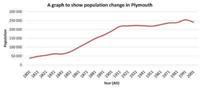
In August 2008, the Office for National Statistics estimated that Plymouth's unitary authority area population for mid-2007 was 250,700,[54] 9,980 more people than that of the last census from 2001, which indicated that Plymouth had a population of 240,720.[55] The average household size was 2.3 persons.[56] To the right is a graph showing the population change of the city since 1801. The population rose rapidly during the second half of the 19th century, but declined by over 1.6% from 1931 to 1951. Plymouth's gross value added (a measure of its economy) was 3.501 billion GBP in 2004 making up approximately one quarter of Devon's economy.[57] Its GVA per capita was £14,327 and compared to the national average of £17,115, it was £2,788 lower.[57] Between 1997 and 2007 unemployment decreased from 10.8% to 6.2%, but unemployment in the city still remains significantly above the national average.[58] At the time of the 2001 UK census, the ethnic composition of Plymouth's population was 98.4% White, with the largest minority ethnic group being Chinese at 0.3%.[55]
Economy

Because of its coastal location, the economy of Plymouth has traditionally been maritime, in particular the defence sector with over 12,000 people employed and approximately 7,500 in the armed forces.[60] Since the 1980s, employment in the defense sector has decreased substantially and the public sector is now prominent particularly in administration, health, education, medicine and engineering.[60] Devonport Dockyard is the UK's only naval base that refits nuclear submarines and the Navy estimates that the Dockyard generates about 10% of Plymouth's income.[61] Plymouth has the largest cluster of marine and maritime businesses in the south west with 270 firms operating within the sector.[62] Other substantial employers include the university with 30,000 students and almost 3,000 staff,[63] as well as the Tamar Science Park employing 500 people in 50 companies, which is the fastest growing science park in the United Kingdom.[60]
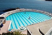
Plymouth has a post-war shopping area in the city centre with substantial pedestrianisation.[25] At the west end of the zone inside a grade II listed building is the Pannier Market that was completed in 1959 — pannier meaning "basket" from French, so it translates as "basket market".[64] In terms of retail floorspace, Plymouth is ranked in the top five in the South West,[65] and 29th nationally.[66] Plymouth was one of the first ten British cities to trial the new Business Improvement District initiative.[67] The Tinside Pool is situated at the foot of the Hoe and became a grade II listed building in 1998 before being restored to its 1930s look for £3.4 million.[68]
Plymouth 2020

Plymouth Council is currently undertaking a project of urban redevelopment called the 'Vision for Plymouth' launched by the architect David Mackay and backed by Plymouth City Council.[69] Its projects range from shopping centres, cruise terminals and a boulevard to reach a population of 300,000, and building 33,000 dwellings.[69]

In 2004 the old Drake Circus shopping centre and Charles Cross car park were demolished and replaced by the latest Drake Circus Shopping Centre, which opened in October 2006.[70] It received negative feedback before opening when David Mackay said it was already "ten years out of date".[70] In contrast, the Theatre Royal's production and education centre, TR2, which was built on wasteland at Cattedown, was a runner-up for the RIBA Stirling Prize for Architecture in 2003.[71]
There is a project involving the future relocation of Plymouth City Council's headquarters, the civic centre, to the current location of the Bretonside bus station; it would involve both the bus station and civic centre being demolished and a rebuilt together at the location with the land from the civic centre being sold off.[72] Other suggestions include the demolition of the Plymouth Pavilions entertainment arena to create a canal 'boulevard' linking Millbay to the city centre. Millbay is being regenerated with mixed residential, retail and office space alongside the ferry port.[73]
Transport

- See also: Railways in Plymouth
The A38 dual-carriageway runs from east to west across the geographical centre of the city.[74] Heading east, it connects Plymouth to the M5 motorway about 40 miles (64 km) away near Exeter and heading west, it connects Cornwall and Devon via the Tamar Bridge.[74] Regular bus services are provided by Plymouth Citybus First Group and Target Travel.[75] There are three Park and ride services located at Milehouse, Coypool (Plympton) and George Junction (Plymouth City Airport), which are operated by First Group.[76]

A regular international ferry service provided by Brittany Ferries operates from Millbay taking cars and foot passengers directly to France (Roscoff) and Spain (Santander) via the two ferries: MV Bretagne and MV Pont-Aven.[77] There is a passenger ferry between Stonehouse and the Cornish hamlet of Cremyll, which is believed to have continuously operated since 1204.[78] There is also a pedestrian ferry from the Mayflower Steps to Mount Batten,[79] and an alternative to using the Tamar Bridge via the Torpoint Ferry (vehicle and pedestrian) across the River Tamar.[80]
The city's airport is Plymouth City Airport about 4 miles (6.4 km) north of the city centre.[81] The airport is home to the local airline Air Southwest,[82] which operates flights across the British Isles and France.[83] In June 2003 a report by the South West RDA was published looking at the future of aviation in the south west and the possible closure of airports.[84] It concluded that the best option for the South West was to close Plymouth City Airport and expand nearby Exeter International Airport and Newquay Cornwall Airport, although it did conclude that this was not the best option for Plymouth.[85]
Plymouth railway station, which opened in 1877,[86] is managed by First Great Western and also sees trains on the CrossCountry and South West Trains networks.[87] Smaller stations are served by local trains on the Tamar Valley Line and Cornish Main Line.[88] First Great Western have come under fire recently, due to widespread rail service cuts across the south west, which affect Plymouth greatly.[89] Three MPs from the three main political parties in the region have lobbied that the train services are vital to its economy.[90]
Education

The University of Plymouth is the 11th largest university in the United Kingdom (excluding the Open University).[91] It has over thirty thousand students, almost three thousand staff and an annual income of around £160 million.[63] It was founded in 1992 from Polytechnic South West following The Further and Higher Education Act 1992.[92] It has courses in maritime business, marine engineering, marine biology and Earth, ocean and environmental sciences, surf science, shipping and logistics.[93]
The city is also home to three large colleges. The University College Plymouth St Mark & St John (known as "Marjon"), which specialises in teacher training, offers training across the country and abroad.[94] The City College Plymouth provides courses from the most basic to Foundation degrees for approximately 26,000 students.[95] The Plymouth College of Art and Design (known as "PCAD") offers a selection of courses including Media. It was started 153 years ago and is now one of only four independent colleges of art and design in the UK.[96] Plymouth also has 71 state primary phase schools, 13 state secondary schools, eight special schools and three selective grammar schools[97], as well as the Plymouth College independent school.
Plymouth is home to Plymouth Marine Laboratory, an independent collaborative centre, who study the area for scientific research. They study the marine ecosystems in and near Plymouth to provide future solutions for marine extinctions across the United Kingdom.[98]
Religion

Plymouth has about 150 churches and its Catholic cathedral (1858) is in Stonehouse.[99][100] The city's oldest church is St Andrews (Anglican) located at the top of Royal Parade — it is the biggest parish church in Devon and has been a site of gathering since 800 AD.[99] The city also includes five baptist churches, an Orthodox Greek church and 13 Roman Catholic churches.[101] In 1831 the first Brethren assembly in England, a movement of conservative non-denominational Evangelical Christians, was established in the city, so that Brethren are often called Plymouth Brethren, although the movement did not begin locally.[102]
Plymouth has the first known reference to Jews in the South West from Sir Francis Drake's voyages in 1577 to 1580, as his log mentioned "Moses the Jew" — a man from Plymouth.[99] The synagogue is a Listed Grade II* building, built in 1762 and is the oldest Ashkenazi Synagogue in the English speaking world.[103] There are also places of worship for Islam, Bahá'í, Buddhism, Chinese beliefs and Humanism.[104]
73.6% of the population described themselves in the last census return as being at least nominally Christian with all other religions represented by less than 0.5% each. The number of people without a religion is above the national average at 18.3%, with 7.1% not stating their religion.[55]
Sports

Plymouth is home to Plymouth Argyle Football Club, who play in the Football League Championship (second tier of English football) at the Home Park stadium in Central Park.[105] It is Plymouth's only professional football team, however the city used to have another team called Plymouth United F.C. dating back to 1886.[106] It links itself with the group of English non-conformists that left Plymouth for the New World in 1620: its nickname is "The Pilgrims",[107] and the club crest features the Mayflower.
Other sports clubs include Plymouth Albion R.F.C. and the Plymouth Raiders basketball club. Plymouth Albion Rugby Football Club is a rugby union club that was founded in 1875 and are currently in the second tier of English rugby union.[108] Plymouth Raiders play in the British Basketball League — the top tier of British basketball. They play at the Plymouth Pavilions entertainment arena and were founded in 1983.[109] Plymouth is also home to two American Football clubs: The Plymouth Admirals and the Plymouth Blitz.
Culture
Built in 1815, Union Street was at the heart of Plymouth historical culture.[110] It became known as the servicemens playground, as it was where sailors from the Royal Navy would seek entertainment.[110] During the 1930s, there were 30 pubs and it attracted such performers as Charlie Chaplin to the Palace Theatre.[110] It is now the late-night hub of Plymouth's entertainment strip,[111] but has a reputation for trouble at closing hours.[112]
Outdoor events and festivals are held including the annual British Firework Championships in August, which attracts tens of thousands of people across the waterfront.[113] In August 2006 the world record for the most amount of simultaneous fireworks was surpassed, by Roy Lowry of the University of Plymouth, over Plymouth Sound.[114] Since 1992 the Music of the Night has been performed in the Royal Citadel by the 29 Commando Regiment and local performers to raise money for local and military charities.[115]

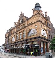
The city's main theatres are the Theatre Royal (1,315 capacity),[116] its Drum Theatre (200 capacity),[117] and its newly built production and creative learning centre, The TR2. [118] The Plymouth Pavilions has multi uses for the city staging music concerts, basketball matches and stand-up comedy.[119] There are also three cinemas: ABC Cinema at Derrys Cross, Plymouth Arts Centre at Looe Street and a Vue cinema at the Barbican Leisure Park.[120] The Plymouth City Museum and Art Gallery is operated by Plymouth City Council allowing free admission — it has six galleries.[121]
Plymouth is the regional television centre of BBC South West "Spotlight".[122]. The ITV's television studio of Westcountry news (Devon and Cornwall) is headquartered in Plymouth, but is due to close following a merge with ITV West in the Bristol area.[123] The main local newspapers serving Plymouth are The Herald and Western Morning News with BBC Radio Devon and Plymouth Sound being the main local radio stations.[124]
Public services

Since 1973 Plymouth has been supplied water by South West Water. Prior to the 1973 take over it was supplied by Plymouth County Borough Corporation.[125] Before the 19th century two leats were built in order to provide drinking water for the town. They carried water from Dartmoor to Plymouth. A watercourse, known as Plymouth or Drake's Leat, was opened on 24 April 1591 to tap the River Meavy.[126] The Devonport Leat was constructed to carry fresh drinking water to the expanding dockyards at Devonport. It was fed by three Dartmoor rivers: The West Dart, Cowsic and Blackabrook. It seems to have been carrying water since 1797, but it was officially completed in 1801. It was originally designed to carry water to Devonport Dockyard, but has since been shortened and now carries water to Burrator Reservoir, which feeds most of the water supply of Plymouth.[127] Burrator Reservoir is located about 5 miles (8.0 km) north of the city and was constructed in 1898 and expanded in 1928.[128]
Plymouth City Council is responsible for waste management throughout the city and South West Water is responsible for sewerage.[129][130] Plymouth's electricity is supplied from the National Grid and distributed to Plymouth via Western Power Distribution.[131] On the outskirts of Plympton a combined cycle gas-powered station, the Langage Power Station, is due to start producing electricity for Plymouth in the winter of 2008/2009.[132]
Plymouth is served by Plymouth Hospitals NHS Trust and the city's NHS hospital is Derriford Hospital 4 miles (6.4 km) north of the city centre and there is also the Royal Eye Infirmary near the city centre.[133] South Western Ambulance Service NHS Trust operates in Plymouth and the rest of the south west; its headquarters are in Exeter.[134] Her Majesty's Courts Service provide a Magistrates' Court and a Combined Crown and County Court in the city.[135][136] The Plymouth Borough Police, formed in 1836, eventually became part of Devon and Cornwall Constabulary.[137] There are police stations at Charles Cross and Crownhill (the Divisional HQ) and smaller stations at Plympton and Plymstock.[138] The city has one of the Devon and Cornwall Area Crown Prosecution Service Divisional offices.[139] Plymouth has five fire stations located in Camel's Head, Crownhill, Greenbank, Plympton (West Devon HQ) and Plymstock which is part of Devon and Somerset Fire and Rescue Service.[140]
Notable people

People from Plymouth are known as Plymothians or less formally as Janners.[141] Its meaning is described as a person from Devon, deriving from Cousin Jan (the Devon form of John), but more particularly in naval circles anyone from the Plymouth area.[142] The Elizabethan navigator, Sir Francis Drake was born in nearby town of Tavistock and was the mayor of Plymouth.[143] There is a Leat, a Shopping Centre, several ships and an Island named after him, as well as a statue of him touching a globe on Plymouth Hoe. He was the first Englishman to circumnavigate the world and was known by the Spanish as El Draco meaning "The Dragon" after he raided many of their ships.[144] He died of dysentery in 1596 off the coast of Puerto Rico.[145] In 2002 a mission to recover his body and bring it to Plymouth was allowed by the Ministry of Defence.[146] Antarctic explorers Robert Falcon Scott and Frank Bickerton both lived in the city.[147][148] Artists include Beryl Cook whose paintings depict the culture of Plymouth[149] and Robert Lenkiewicz, whose paintings looked at themes such as: vagrancy, sexual behaviour and suicide, lived in the city from the 1960s until his death in 2002.[150] In addition, George Passmore of Turner Prize winning duo Gilbert and George was born in the city.[151] Notable athletes include swimmer Sharon Davies,[152] diver Tom Daley,[153] dancer Wayne Sleep,[154] and footballer Trevor Francis.[155] Other past residents include composer Ron Goodwin,[156] and journalist Angela Rippon.[157]
Landmarks
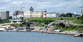
After the English Civil War the Royal Citadel was built in 1666 on the east end of Plymouth Hoe, to defend the port from naval attacks, suppress Plymothian Parliamentary leanings and to train the armed forces.[17] Further west is Smeaton's Tower, which was built in 1759 as a lighthouse on rocks 14 miles (23 km) off shore, but dismantled and the top two thirds rebuilt on the Hoe in 1877.[158] Today it attracts tourists for its views over Plymouth Sound and the rest of the city, via a staircase to the glazed lantern.[159] Plymouth has 20 war memorials of which nine are on The Hoe including: Plymouth Naval war memorial, to remember those killed in World War One and Two, and the National Armada memorial, to commemorate the defeat of the Spanish Armada.[160]
The early port settlement of Plymouth, called 'Sutton', approximates to the area now referred to as the Barbican and has 100 listed buildings and the largest concentration of cobbled streets in Britain.[161] The Pilgrim Fathers left for the New World in 1620 near the commemorative Mayflower Steps in Sutton Pool.[162] A mile upstream on the opposite side of the River Plym is the Saltram estate, which has a Jacobean and Georgian mansion.[163]
References
- ↑ "A new life in the New World". The BBC (2008-02-01). Retrieved on 2008-09-02.
- ↑ 2.0 2.1 2.2 2.3 "Brief history of Plymouth". Plymouth City Council. Retrieved on 2008-07-20.
- ↑ "Ethnic Group". Office for National Statistics (2004-10-09). Retrieved on 2008-08-30.
- ↑ Andrew T. Chamberlain, Keith W. Ray, Charlotte Henderson, Richard Welton Fisher (1994). A Catalogue of Quaternary Fossil-bearing Cave Sites in the Plymouth Area. Royal Albert Memorial Museum. ISBN 1855223457.
- ↑ Cunliffe, Barry (2004). "Britain and the Continent:Networks of Interaction". in Malcolm Todd. A Companion to Roman Britain. Blackwell Publishing. pp. 3. ISBN 0631218238. http://books.google.com/books?id=SYMFtWb-DYQC&printsec=frontcover. Retrieved on 2008-06-23.
- ↑ 6.0 6.1 6.2 6.3 6.4 6.5 "The early history of Plymouth". Plymouth City Council. Retrieved on 2008-07-19.
- ↑ Eilert Ekwall (1981). The Concise Oxford Dictionary of English Place-names. Oxford [Eng.]: OUP. pp. 369. ISBN 0 19 869103 3.
- ↑ Plymouthdata.info attributes this statement to Crispin Gill.
- ↑ Sumption, Jonathan (1999). "Sluys and Tournai: The War of the Alberts". The Hundred Years War: Trial by Battle. University of Pennsylvania Press. pp. 347. ISBN 0812216555. http://books.google.com/books?id=V6vghfDY7loC&printsec=frontcover#PRA2-PA347,M1. Retrieved on 2008-06-29.
- ↑ "Devon timeline". Devon County Council. Retrieved on 2008-06-29.
- ↑ Jewitt, Llewellynn Frederick (1873). A history of Plymouth. Oxford University. pp. 648.
- ↑ 12.0 12.1 "Slave Ships in Plymouth". Plymouth City Council. Retrieved on 2008-07-26.
- ↑ "Adventurers and Slavers". The National Archives. Retrieved on 2007-10-13.
- ↑ 14.0 14.1 "Sir Francis Drake". The BBC. Retrieved on 2008-07-24.
- ↑ Kellogg, William O. (2003). American History the Easy Way: The Easy Way. Hauppauge, N.Y.: Barron's. pp. 20. ISBN 0764119737. http://books.google.com/books?id=mKhRlkY278QC&printsec=frontcover#PPA20,M1. Retrieved on 2008-11-14.
- ↑ 16.0 16.1 16.2 "Siege". The BBC (2003-01-06). Retrieved on 2008-07-06.
- ↑ 17.0 17.1 "Coast Walks: Point 3 - The Citadel". The BBC (2008-01-25). Retrieved on 2008-07-05.
- ↑ Carrington, Henry Edmund (1828). The Plymouth and Devonport guide. Oxford University. pp. 1. http://books.google.com/books?id=Ve4GAAAAQAAJ&printsec=titlepage. Retrieved on 2008-07-05.
- ↑ "Cargo and Trade, Ocean Landing Pier" (PDF). Plymouth City Museum and Art Gallery. Retrieved on 2008-07-26.
- ↑ 20.0 20.1 "Plymouth, John Foulston". Plymouth Data. Retrieved on 2008-05-16.
- ↑ "Imports". Plymouth Data (2005-08-30). Retrieved on 2008-07-24.
- ↑ 22.0 22.1 "Characteristics of the City of Plymouth (Historical and industrial legacy)". Plymouth City Council. Retrieved on 2008-07-24.
- ↑ Gill, Crispin (1993). Plymouth. A New History. Devon Books. pp. 259–262. ISBN 0-86114-882-7.
- ↑ 24.0 24.1 Gould, Jeremy (March 2007). Architecture and the Plan for Plymouth: The Legacy of a British City. Architectural Review.
- ↑ 25.0 25.1 25.2 25.3 25.4 25.5 25.6 Gill, Crispin (1993). Plymouth. A New History. Devon Books. pp. 262–267. ISBN 0-86114-882-7.
- ↑ "Frosty response to church climb", The BBC (2005-11-17). Retrieved on 2008-11-22.
- ↑ "Three Towns Amalgamation", The Times (1914-02-09).
- ↑ "Union of Plymouth and Devonport", The Times (1914-05-04).
- ↑ "The City of Plymouth", The Times (1928).
- ↑ "South West Regional Office of the Labour Party archives" 38423/32. The National Archives (1972-03-21). Retrieved on 2008-07-20.
- ↑ Department of the Environment (1996-07-18). The Devon (City of Plymouth and Borough of Torbay) (Structural Change) Order 1996. Office of Public Sector Information. ISBN 0110627792. http://www.opsi.gov.uk/si/si1996/Uksi_19961865_en_1.htm. Retrieved on 2008-07-26.
- ↑ "Coat of arms". Plymouth City Council. Retrieved on 2008-09-02.
- ↑ 33.0 33.1 "Boundaries". Plymouth City Council. Retrieved on 2008-09-03.
- ↑ "Electorate details, register statistics and annual performance". Plymouth City Council. Retrieved on 2008-11-18.
- ↑ "Your councillors". Plymouth City Council. Retrieved on 2008-09-03.
- ↑ "Final recommendations for Parliamentary Constituencies in the constituencies of Devon, Plymouth and Torbay" (DOC) 4. The UK Statistics Authority. Retrieved on 2008-09-03.
- ↑ 37.0 37.1 "Lord Mayoralty". Plymouth City Council. Retrieved on 2008-09-06.
- ↑ 38.0 38.1 38.2 "Elected representatives". Plymouth City Council. Retrieved on 2008-09-01.
- ↑ "Councillor Vincent elected as Lord Mayor Designate", Plymouth City Council (2008-02-29). Retrieved on 2008-09-06.
- ↑ 40.0 40.1 "Elliot Terrace". Plymouth City Council. Retrieved on 2008-02-16.
- ↑ "Council opposes building listing", The BBC (2007-07-10). Retrieved on 2008-11-20.
- ↑ "Twin towns". Plymouth City Council. Retrieved on 2008-03-01.
- ↑ 43.0 43.1 "Climatological Normals of Plymouth - 1961-1990". Climatological Information for United Kingdom and Ireland. The Hong Kong Observatory. Retrieved on 2008-06-09.
- ↑ 44.0 44.1 44.2 "Devon's rivers: The Tamar". The BBC (2008-02-06). Retrieved on 2008-07-08.
- ↑ Otter, R. A. (1994). "The Tamar Valley and Plymouth". Civil Engineering Heritage: Southern England. Thomas Telford. pp. 48. ISBN 0727719718. http://books.google.com/books?id=HG-l2kpKPFUC&printsec=frontcover#PPA48,M1. Retrieved on 2008-07-08.
- ↑ Report and Transactions. 9. Devonshire Association for the Advancement of Science. 1877. pp. 426. http://books.google.com/books?id=Q1QDAAAAMAAJ&q=Plymouth+Hoe+limestone&dq=Plymouth+Hoe+limestone&pgis=1. Retrieved on 2008-07-11.
- ↑ "Population Density". Census 2001. The Office for National Statistics. Retrieved on 2008-06-20.
- ↑ 48.0 48.1 "Characteristics of the City of Plymouth (The geography)". Plymouth City Council. Retrieved on 2008-07-25.
- ↑ 49.0 49.1 49.2 49.3 49.4 "Characteristics of the City of Plymouth (The geology)". Plymouth City Council. Retrieved on 2008-07-26.
- ↑ "Plymouth Sound Shores and Cliffs" (pdf). Natural England. Retrieved on 2008-11-27.
- ↑ "Characteristics of the City of Plymouth (Limestone)". Plymouth City Council. Retrieved on 2008-07-26.
- ↑ 52.0 52.1 "Parks and open spaces". Plymouth City Council. Retrieved on 2008-09-01.
- ↑ 53.0 53.1 53.2 "About south-west England". The Met Office. Retrieved on 2006-05-28.
- ↑ "Plymouth’s population 2007". Plymouth City Council website. The Office for National Statistics (2008-08-21). Retrieved on 2008-11-22.
- ↑ 55.0 55.1 55.2 "Plymouth UA". Census 2001. The Office for National Statistics. Retrieved on 2008-02-15.
- ↑ "Facts and figures". Plymouth City Council. Retrieved on 2008-02-14.
- ↑ 57.0 57.1 "Sub-regional: Gross value added (GVA) at current basic prices (South West)" (Excel). Office for National Statistics (December 2006). Retrieved on 2008-07-26.
- ↑ "Unemployed (Model Based)". nomis website. The Office for National Statistics. Retrieved on 2008-06-28.
- ↑ "HMNB Devonport". The Royal Navy. Retrieved on 2007-10-18.
- ↑ 60.0 60.1 60.2 "Business and economy". Plymouth City Council. Retrieved on 2008-07-17.
- ↑ "HMNB Devonport". The Royal Navy. Retrieved on 2008-09-07.
- ↑ "Marine Sector". Plymouth City Council website. The University of Plymouth. Retrieved on 2008-07-22.
- ↑ 63.0 63.1 "University of Plymouth - an introduction". The University of Plymouth. Retrieved on 2008-11-16.
- ↑ "History of pannier market". Plymouth City Council. Retrieved on 2008-02-16.
- ↑ "Town Centre Performance & Retail Ranking Update, May 2007" (PDF). South West Regional Board. Retrieved on 2008-02-16.
- ↑ "Facts and figures". Plymouth City Council. Retrieved on 2008-02-20.
- ↑ "Established BIDs". National BIDs Advisory Service. Retrieved on 2008-02-16.
- ↑ "Point 6 - Tinside Pool". The BBC (2008-01-25). Retrieved on 2008-11-16.
- ↑ 69.0 69.1 "A vision for Plymouth". Plymouth City Council. Retrieved on 2008-09-01.
- ↑ 70.0 70.1 "Controversy over £200m shops plan", The BBC (2006-10-05). Retrieved on 2007-10-13.
- ↑ "Changing perceptions of Plymouth", The BBC (2006-10-05). Retrieved on 2008-11-15.
- ↑ "Civic centre demolition backed", The BBC (2007-09-25). Retrieved on 2008-11-15.
- ↑ "Dock regeneration plan boosted", The BBC (2002-12-19). Retrieved on 2008-06-29.
- ↑ 74.0 74.1 Ordnance Survey. (2005-10-03). Lower Tamar Valley & Plymouth. Ordnance Survey. ISBN 0319235270. http://leisure.ordnancesurvey.co.uk/leisure/ItemDetails.jsp?item=os_explorer_108. Retrieved on 2008-11-16.
- ↑ "Bus enquires and services". Plymouth City Council. Retrieved on 2008-11-16.
- ↑ "Park and ride". Plymouth City Council. Retrieved on 2008-11-16.
- ↑ "Plymouth Ferry Terminal Guide". Brittany Ferries website. Retrieved on 2008-07-12.
- ↑ "Cremyll ferry". Plymouth City Council. Retrieved on 2008-11-16.
- ↑ "Mount Batten Ferry general info". Mount Batten Ferry website. Retrieved on 2008-11-16.
- ↑ "Torpoint ferry". Plymouth City Council. Retrieved on 2008-11-16.
- ↑ "View of the aircraft parking area and runway at Plymouth City Airport". The BBC. Retrieved on 2008-11-16.
- ↑ "About Us". Air Southwest. Retrieved on 2008-11-16.
- ↑ "Plymouth City Airport Flights". Plymouth City Airport. Retrieved on 2008-11-16.
- ↑ "Air strategy for the far South West published", The South West RDA (2003-06-06). Retrieved on 2008-11-16.
- ↑ "New blow for city airport", The BBC (2003-06-07). Retrieved on 2008-11-16.
- ↑ "Plymouth Station celebrates 130th birthday", First Great Western (2007-03-28). Retrieved on 2008-11-16.
- ↑ "Station Facilities: Plymouth (PLY)". Retrieved on 2008-11-16.
- ↑ "Plymouth ---> Gunnislake Train Timetable" (PDF). Network Rail. Retrieved on 2008-05-17.
- ↑ "Biggest cuts since Beeching will slash rural train services", The Times (2006-02-25). Retrieved on 2008-05-31.
- ↑ "MPs join forces against train cut", The BBC (2005-06-26). Retrieved on 2008-05-31.
- ↑ "List of universities by number of students" (Excel). The Higher Education Statistics Agency. Retrieved on 2008-05-30.
- ↑ "Our history". The University of Plymouth. Retrieved on 2008-11-16.
- ↑ "Undergraduate courses A-Z". The University of Plymouth. Retrieved on 2008-06-18.
- ↑ "The History of the University College". The University College Plymouth St Mark & St John. Retrieved on 2008-06-19.
- ↑ "The College". City College Plymouth. Retrieved on 2008-06-19.
- ↑ "PCAD home page". Plymouth College of Art and Design. Retrieved on 2008-06-19.
- ↑ "Schools". Plymouth City Council. Retrieved on 2008-06-19.
- ↑ "Partnerships and organisations". Plymouth City Council website. Plymouth Marine Laboratory website. Retrieved on 2008-07-22.
- ↑ 99.0 99.1 99.2 "Places of worship". Plymouth City Council. Retrieved on 2008-09-02.
- ↑ "Plymouth Cathedral 1858 - 2008: 150th Anniversary Celebrations". Roman Catholic Diocese of Plymouth. Retrieved on 2008-09-02.
- ↑ "Christian". Plymouth City Council. Retrieved on 2008-09-02.
- ↑ "The Exclusive Brethren History". The BBC (2004-02-04). Retrieved on 2008-07-13.
- ↑ "Synagogue, Catherine Street, Plymouth". English Heritage. Retrieved on 2008-11-22.
- ↑ "Other faiths, religions and beliefs". Plymouth City Council. Retrieved on 2008-09-02.
- ↑ "Divisional League Table". The Football League. Retrieved on 2008-08-31.
- ↑ Official Fixture Card, Argyle Football Club, 1886
- ↑ "History of Plymouth Argyle". The BBC (2008-02-18). Retrieved on 2008-08-31.
- ↑ "History of Plymouth Albion RFC". Plymouth Albion R.F.C. website. Retrieved on 2008-06-21.
- ↑ "History". Plymouth Raiders website. Retrieved on 2008-06-21.
- ↑ 110.0 110.1 110.2 "Union Street: night and day". Devon Community Life. The BBC (2006-07-24). Retrieved on 2008-06-22.
- ↑ "Haven for casualties of the night", The BBC (2008-11-14). Retrieved on 2008-11-16.
- ↑ Else, David (2007). England. Lonely Planet. pp. 340. ISBN 1741045673. http://books.google.com/books?id=NbUNF2Ter70C&printsec=frontcover#PPA340,M1. Retrieved on 2008-11-16.
- ↑ "The British Firework Championships Plymouth". The British Firework Championships website. Retrieved on 2008-11-02.
- ↑ "Rocket man sets record", The BBC (2006-11-02). Retrieved on 2008-06-21.
- ↑ "About Music Of The Night". Music of the Night. Retrieved on 2008-11-16.
- ↑ "Theatre Royal". The Theatre Royal. Retrieved on 2008-11-16.
- ↑ "Drum Theatre". The Theatre Royal. Retrieved on 2008-11-16.
- ↑ "TR2". The Theatre Royal. Retrieved on 2008-11-16.
- ↑ "About Us". The Plymouth Pavilions.
- ↑ "Cinemas". Plymouth City Council. Retrieved on 2008-11-17.
- ↑ "Plymouth City Museum and Art Gallery". Plymouth City Council. Retrieved on 2008-11-17.
- ↑ "Spotlight (address footnote)". BBC South West. Retrieved on 2008-11-17.
- ↑ "ITV West Country staff to be axed", The BBC (2008-09-30). Retrieved on 2008-11-16.
- ↑ "Creative Sector". Plymouth City Council. Retrieved on 2008-11-17.
- ↑ The South West Water Authority Constitution Order 1973 (1973 No. 1307)
- ↑ "The Drake's or the Plymouth Leat". Plymouth Data (2007-05-14). Retrieved on 2008-08-31.
- ↑ "The Dock of Devonport Leat". Plymouth Data (2008-06-18). Retrieved on 2008-08-31.
- ↑ "The History of Dartmoor". Dartmoor National Park Authority. Retrieved on 2008-08-31.
- ↑ "Rubbish and recycling". Plymouth City Council. Retrieved on 2008-05-31.
- ↑ "About SWW". South West Water. Retrieved on 2008-08-31.
- ↑ "Western Power Distribution home page". Western Power Distribution. Retrieved on 2008-08-31.
- ↑ "Power plant gets go-ahead at last", The BBC (2006-06-16). Retrieved on 2008-05-31.
- ↑ "About Us". Plymouth Hospitals NHS Trust. Retrieved on 2008-11-16.
- ↑ "Welcome to the South Western Ambulance Service NHS Trust website". The South Western Ambulance Service NHS Trust. Retrieved on 2008-11-17.
- ↑ "Magistrates' Court search". Her Majesty's Courts Service. Retrieved on 2008-11-17.
- ↑ "Combined Crown and County Court search". Her Majesty's Courts Service. Retrieved on 2008-11-17.
- ↑ "Plymouth City Police (1928 - 1967) - Devon & Cornwall Constabulary". Devon and Cornwall Constabulary. Retrieved on 2008-02-16.
- ↑ "Plymouth Police Station Details — Devon & Cornwall Constabulary". Devon and Cornwall Constabulary. Retrieved on 2008-02-16.
- ↑ "Your Local CPS : Devon and Cornwall". The Crown Prosecution Service. Retrieved on 2008-02-16.
- ↑ "West Devon". Devon and Somerset Fire and Rescue Service. Retrieved on 2008-09-01.
- ↑ "Anger over slave trader pub name", The BBC (2008-03-27). Retrieved on 2008-11-16.
- ↑ Routledge, Cyril Tawney; Kegan Paul (1987). Grey Funnel Lines: Traditional Song & Verse of the Royal Navy, 1900-1970. London: Routledge & Kegan Paul. ISBN 978-0710212702.
- ↑ "Sir Francis Drake". The BBC. Retrieved on 2008-12-03.
- ↑ Rasor, Eugene (2004). English/British Naval History to 1815: A Guide to the Literature. Greenwood Publishing Group. pp. 190. ISBN 0313305471. http://books.google.com/books?id=D4oNNsTdvEoC&printsec=frontcover#PPA190,M1. Retrieved on 2008-09-02.
- ↑ "Sir Francis Drake (c.1540 - c.1596)". The BBC. Retrieved on 2008-08-31.
- ↑ "Mission to rescue Drake's body", The BBC (2001-11-12). Retrieved on 2008-08-31.
- ↑ "Robert Falcon Scott". The BBC. Retrieved on 2008-08-31.
- ↑ "Antarctic explorer Frank Bickerton". The BBC. Retrieved on 2008-06-08.
- ↑ "Painter Beryl Cook dies aged 81", The BBC (2007-05-28). Retrieved on 2008-06-08.
- ↑ "Controversial artist". The BBC (2008-01-30). Retrieved on 2008-08-31.
- ↑ "Gilbert & George Britannica Online Encyclopaedia". Britannica Online Encyclopaedia. Retrieved on 2008-11-31.
- ↑ "New centre to honour Plymouth Olympian Sharron Davies", Plymouth City Council (2007-03-14). Retrieved on 2008-08-31.
- ↑ "Thomas Daley Biography". The British Olympic Association. Retrieved on 2007-02-12.
- ↑ "About Sleep". Wayne Sleep's website. Retrieved on 2008-08-31.
- ↑ "Englishmen Abroad: Trevor Francis". The FA (2003-07-07). Retrieved on 2008-08-31.
- ↑ "Plymouth's movie maestro". The BBC (2008-01-30). Retrieved on 2008-08-31.
- ↑ "The talented Angela Rippon". This Is Hampshire (2000-08-19). Retrieved on 2008-08-31.
- ↑ "Coast Walks: Point 5 - Smeaton's Tower". The BBC (2008-01-25). Retrieved on 2008-07-05.
- ↑ "Smeaton's Tower". Plymouth City Council. Retrieved on 2008-09-03.
- ↑ "War memorials". Plymouth City Council. Retrieved on 2008-09-02.
- ↑ "Plymouth's Historic Barbican". The BBC (2008-02-18). Retrieved on 2008-11-16.
- ↑ "Point 8a - Mayflower Steps". The BBC (2008-01-07). Retrieved on 2008-07-05.
- ↑ "Saltram". The National Trust. Retrieved on 2008-07-06.
- Dunning, Martin (2001). Around Plymouth.
- Gill, Crispin (1993). Plymouth: A New History. Devon Books.
- Robinson, Chris (2004). Plymouth Then & Now. Plymouth Prints.
- Casley, Nicholas (1997). The Medieval Incorporation of Plymouth and a Survey of the Borough's Bounds. Old Plymouth Society.
- Carew, Richard (1555). The Survey of Cornwall. http://www.gutenberg.org/dirs/etext06/srvcr10.txt. N.B. Carew refers to Plymouth Hoe as "the Hawe at Plymmouth"
- Abercrombie, Patrick; James Watson, Laurence Stamp and Gilbert Robinson, (1944-04-27). A Plan for Plymouth. Underhill. http://books.google.com/books?id=nAYcAAAAIAAJ. N.B. the publication carries the date 1943, which is incorrect
External links
- Plymouth City Council website
- Plymouth Picture Postcards (mostly pre-WWII)
- The Encyclopaedia of Plymouth History
|
|||||
|
||||||||||||||
|
|||||||||||
|
||||||||||||||||||||