Pico de Orizaba
| Pico de Orizaba | |
|---|---|
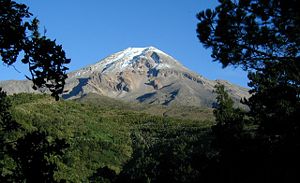 Citlaltépetl from above Xometla |
|
 Pico de Orizaba
|
|
| Elevation | 5,636 metres (18,490 ft)[1] |
| Location | Veracruz-Puebla,Mexico |
| Prominence | 4,922 m (16,150 ft) Ranked 7th |
| Coordinates | |
| Type | Stratovolcano |
| Volcanic arc/belt | Trans-Mexican Volcanic Belt |
| Last eruption | 1687 |
| First ascent | 1848 by F. Maynard & G. Reynolds |
| Easiest route | snow/ice climb |
| Listing | Volcanic Seven Summits Country high point Ultra |
The Pico de Orizaba, or Citlaltépetl (from Nahuatl citlal(in) = star, and tepētl = mountain), is a stratovolcano, the highest mountain in Mexico and the third highest in North America. It rises 5,636 meters (18,490 feet) above sea level in the eastern end of the Eje Volcánico Transversal mountain range, on the border between the states of Veracruz and Puebla. The volcano is currently dormant but not extinct; the last eruptions occurred in 1687, with previous eruptions in 1630, 1613, 1569, 1566, 1545-65? and 1537.
Contents |
General Information
The Pico overlooks the valley and city of Orizaba, from which it gets its name. The name Citlaltépetl is not used by Nahuatl speakers of the Orizaba area, who instead call it Istaktepetl (Iztactépetl in the traditional orthography for Classical Nahuatl) 'White Mountain'.
A regionally dominant peak, and in fact the highest peak between Colombia and the Yukon, the Pico de Orizaba is ranked 7th in the world in topographic prominence. It is the second most prominent volcanic peak in the world after Africa's Mount Kilimanjaro. Although it is about 110 km (75 miles) inland, to the west of the port of Veracruz, its peak is visible to ships approaching the port in the Gulf of Mexico, and at dawn rays of sunlight strike the Pico while Veracruz still lies in shadow. The Pico is ranked 16th in the world for topographic isolation.
The peak is one of three volcanoes that contain permanent snow and glaciers in Mexico. The others are Popocatépetl and Iztaccíhuatl.
A companion peak lying about six km to the southwest of the Pico de Orizaba is the Sierra Negra, at 4,640 metres (15,223 ft). This subsidiary peak, though far lower than its massive neighbor, is still higher than anything in the 48 contiguous states of the U.S., and on its summit, serviced by the highest road in North America, is one of the world's premier astronomical instruments, the Large Millimeter Telescope.
The Pico de Orizaba was important in such pre-Hispanic cultures as those of the Nahuatl-speaking Aztecs and the Totonacs.
The summit and its surrounding foothills are part of a national park. There are many routes for approaching and climbing the volcano, and many people visit it.
Picture gallery
See also

- 4000 meter peaks of México
- 4000 meter peaks of North America
- List of volcanoes in Mexico
- List of volcanoes
- Mountain peaks of México
- Mountain peaks of North America
- Orizaba
- Volcanic Seven Summits
Footnotes
- ↑ The elevation given here is based on a modern survey by a GPS professional. See [1], details of the survey are on page 23. The elevation given by INEGI mapping is 5,611 m. Higher elevations given by various other authorities (including the 5,747 m claimed by the National Geographic Society) are incorrect.
References
- Smithsonian Institution Global Volcanism Program: Pico de Orizaba
- Yarza de la Torre, Esperanza (1971). Volcanes de México. Aguilar. pp. 237 pp. (in Spanish)
- Secor, R. J. (2001). Mexico's Volcanoes: A Climbing Guide (3rd ed.). Mountaineers Books. pp. 160 pp. ISBN 0-89886-798-3.
External links
|
|||||