Pays de la Loire
| Région Pays de la Loire | ||
|---|---|---|
|
||
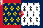
| Region flag | Region logo | |
| Location | ||
|
||
| Administration | ||
| Capital | Nantes | |
| Regional President | Jacques Auxiette (PS) (since 2004) |
|
| Departments | Loire-Atlantique Mayenne Maine-et-Loire Sarthe Vendée |
|
| Arrondissements | 17 | |
| Cantons | 192 | |
| Communes | 1,503 | |
| Statistics | ||
| Land area1 | 32,082 km² | |
| Population | (Ranked 5th) | |
| - January 1, 2007 est. | 3,455,000 | |
| - March 8, 1999 census | 3,222,061 | |
| - Density (2007) | 108/km² | |
| 1 French Land Register data, which exclude lakes, ponds, and glaciers larger than 1 km² (0.386 sq. mi. or 247 acres) as well as the estuaries of rivers |
||
Pays de la Loire is one of the 26 regions of France. It is one of the regions created in the late 20th century to serve as a zone of influence for its capital, Nantes, one of a handful so-called "balancing metropolises" (métropoles d'équilibre)¹. Other examples of "artificially created" regions include Rhône-Alpes, which was created as the region for Lyon, and Midi-Pyrénées, which was created as the region for Toulouse. These regions were created by Pétain under Hitler.
Contents |
Geography
Pays de la Loire is made up of the following historical provinces:
- a part of Brittany, with its old capital Nantes contained within the Loire-Atlantique department. This is only 20% of Brittany. The other 80% of Brittany make up the region of Bretagne.
- Anjou: is largely contained within the Maine-et-Loire department. The whole of the former province of Anjou is contained inside Pays de la Loire.
- Maine: is now divided between the Mayenne and Sarthe departments. The whole of the former province of Maine is contained inside Pays de la Loire.
- a part of Poitou: is contained within the Vendée department. Most of the old province of Poitou is inside the Poitou-Charentes region.
- a part of Perche: is within the northeast of Sarthe department. The rest of Perche is inside the Basse-Normandie and Centre regions.
- a small part of Touraine: southeast of Maine-et-Loire department. Most of the former province of Touraine is inside the Centre region.
Consequently, the name of the region, chosen by the French central government, was not based on history, but purely on geographical references: Pays (i.e. "lands") de la Loire (i.e. "of the Loire River"). However, the majority of the famous châteaux of the Loire Valley are located in the Centre region, and not inside Pays de la Loire, despite the confusing name. The Pays de la Loire present many great monuments as the castles of Angers, Laval, Mayenne and the Nantes "Château des Ducs de Bretagne", the Royal Fontevraud Abbey (the widest monastic ensemble in Europe), the old city of Le Mans but also many Natural Parks (as the Brière, the Marsh of Poitou...).
Demography
Evolution of the population listed by departments:
| Year | Population of the departments | |||||
|---|---|---|---|---|---|---|
| Loire-Atlantique department |
Maine-et-Loire department |
Mayenne department |
Sarthe department |
Vendée department |
Total Pays de la Loire | |
| 1801 | 369.305 | 375.544 | 305.654 | 388.143 | 243.426 | 1.682.072 |
| 1851 | 535.664 | 516.197 | 374.566 | 473.071 | 383.734 | 2.283.232 |
| 1901 | 664.971 | 515 431 | 313.103 | 422.699 | 441.311 | 2.357.515 |
| 1921 | 649.691 | 475.485 | 397.292 | 2.174.150 | ||
| 1936 | 659.428 | 478.404 | 251.348 | 388.519 | 389.211 | 2.166.910 |
| 1946 | 665.064 | 393.787 | 2.224.163 | |||
| 1954 | 733.575 | 395.641 | 2.320.177 | |||
| 1962 | 803.372 | 535 122 | 250.030 | 443.019 | 408.928 | 2.440.471 |
| 1968 | 861.452 | 585.563 | 252.762 | 461.839 | 421.250 | 2.582.866 |
| 1975 | 934.499 | 629.849 | 261.789 | 490 385 | 450.641 | 2.767.163 |
| 1982 | 995.498 | 675.321 | 271.784 | 504.768 | 483.027 | 2.930.398 |
| 1990 | 1.050.539 | 704.668 | 277.748 | 513.280 | 508.962 | 3.055.197 |
| 2005 | 1.208.761 | 754.997 | 297.854 | 551.971 | 587.162 | 3.400.745 |
Major communities
- Rezé
- Saint-Herblain
- Saint-Nazaire
- Saint-Sébastien-sur-Loire
- Saumur
- Vertou
External links
- (French) Regional Council of Pays de la Loire Official Site
- (French) Bretagne Réunie, political group for a United Brittany, oppose the Pays de Loire
- (French) and (Breton) Blog: Nantes is Brittany
- (French) The ligériose, name of a local disease consisting in advertising the "Pays de Loire" without mentioning Breton identity in Nantes
- (English) Official Pays-de-la-Loire Information
Notes
¹ In the 1960s, eight large regional cities of France (Lille, Nancy, Strasbourg, Lyon, Nantes, Bordeaux, Marseille, Toulouse) were made "balancing metropolises", receiving special financial and technical help from the French government in order to counterbalance the excessive weight of Paris inside France.
|
|||||

