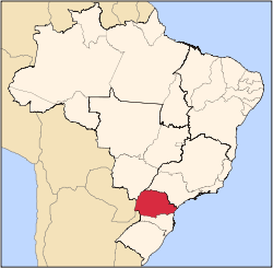
Paraná (state)
|
State of Paraná
|
||||||
|---|---|---|---|---|---|---|
|
||||||
 |
||||||
| Capital (and largest city) |
Curitiba | |||||
| Demonym | Paranaense | |||||
| Government | ||||||
| - | Governor | Roberto Requião | ||||
| - | Vice Governor | Orlando Pessuti | ||||
| Area | ||||||
| - | Total | 199.314,9 km² (9th) | ||||
| Population | ||||||
| - | 2006 estimate | 10,387,378 (6th) | ||||
| - | 2005 census | 10,217,684 | ||||
| - | Density | 52.1/km² (12th) | ||||
| GDP | 2005 estimate | |||||
| - | Total | R$ 126,622,000,000 (5th) | ||||
| - | Per capita | R$ 12,339 (8th) | ||||
| HDI (2005) | 0.820 (high) (6th) | |||||
| Abbreviation | BR-PR | |||||
| Time zone | BRT (UTC-3) | |||||
| - | Summer (DST) | BRST (UTC-2) | ||||

- Other meanings: Paraná, Argentina, Paraná River
Paraná (pronounced [paɾaˈna][1]) is one of the states of Brazil, located in the South of the country, bordering Paraguay and Argentina. Cut by the Tropic of Capricorn, Paraná has what is left of the araucarias forest, one of the most important subtropical forests of the world. At the border with Argentina is the National Park of Iguaçú, considered by UNESCO as Patrimony of the Humanity and the spectacle of the Cataratas do Iguaçú attracts about 700 thousand tourists per year. At only 40 km (24 miles) from there, at the border with Paraguay, the largest dam of the world was built, the Hidroelétrica de Itaipú. The State Park of Vila Velha near the city of Ponta Grossa, is another attraction, with great rocky formations sculptured by the erosion of rain and wind. Curitiba, the capital, is famous for its excellent quality of life, and the Ilha do Mel, next to the historical Paranaguá, is another destination for eco-tourists.
Contents |
Geography
Paraná is bounded on the north by São Paulo state, on the east by the Atlantic Ocean, on the south by Santa Catarina state and the Misiones Province of Argentina, and on the west by Mato Grosso do Sul and the republic of Paraguay, with the Paraná River as its western boundary line.
It state includes two geographic regions, a narrow coastal zone that that is home to the Serra do Mar coastal forests, and a high plateau (2500 to 3000 ft.) whose precipitous, deeply eroded eastern escarpments are known as the Serra do Mar.

The southern and central portions of the state is covered by the Araucaria moist forests, and has large tracts of Yerba Mate (Ilex paraguayensis), known in Brazil as erva mate, used to make a tea called Chimarrão. The plateau slopes westward to the Paraná river, is well watered and moderately fertile, and has a remarkably uniform climate of a mild temperate character; the lower western and northern portions of the state are covered by the Paraná-Paraíba interior forests ecoregion.
The larger rivers of the state comprise the Paranapanema and its tributaries the Cinza and Tibagi, the Ivaí, Piquiri, Jejuí-Guaçu, and the Iguaçu with its principal tributary the Rio Negro. The Paranapanema and a small tributary, the Itararé, form the boundary line with São Paulo west of the Serra do Mar, and the Iguaçu and Negro, the boundary line with Santa Catarina and Argentina - both streams having their sources in the Serra do Mar and flowing westward to the Paraná. The other streams have shorter courses, and all are obstructed by falls and rapids. Twenty miles above the mouth of the Iguaçu are the Iguaçu Falls, 215 ft (66 m). high, broken into twenty or more falls separated by rocks and islands, and surrounded by a wild, unsettled and wooded country. The surface of the plateau is undulating and the greater part is adapted to agricultural and pastoral purposes.
Municipalities
See List of municipalities in Paraná
History

Paraná was first settled by gold prospectors from São Paulo and formed part of the captaincy and province of São Paulo.
The first missions of the Jesuits on the Paraná were situated just above the Guaíra Falls in this state and had reached a highly prosperous condition when the Indian slave hunters of São Paulo (called Bandeirantes) compelled them to leave their settlements and emigrate in mass to what is now the Argentine territory of Misiones. Their principal mission was known as Ciudad Real.
The territory was set apart from São Paulo in 1853. Pedro II of Brazil did so as a punishment for São Paulo support of the insurrection of 1842.
Waves of European immigrants started arriving after 1850, mainly Germans, Italians, Poles and Ukrainians. The development of the state is closely linked to the arrival of the immigrants.
By the early 20th century, the state had two railway systems: the Paranagua to Curitiba (69 miles) with an extension to Ponta Grossa (118 miles) and branches to Rio Negro (55 miles), Porto Amazonas (6 miles) and Antonina (10 miles); and the São Paulo and Rio Grande, which crosses the state from northeast to south-west from União da Vitória, on the Iguaçu, to a junction with the Sorocabana line of São Paulo at Itararé. The junction of the two systems was at Ponta Grossa, north-west of Curitiba.
Demographics


According to the IBGE of 2007, there were 10,410,000 people residing in the state. The population density was 52.1 inh./km².
Urbanization: 84.5% (2006); Population growth: 1.4% (1991-2000); Houses: 3,177,000 (2006).[2]
The last PNAD (National Research for Sample of Domiciles) census revealed the following numbers: 7,620,000 White people (73.1%), 2,394,000 Pardo (Brown) people (23.0%), 270,000 Black people (2.6%), 124,000 Asian or Amerindian people (1.2%).[3]
People of Polish descent predominate in the central and south regions, mainly around Curitiba. Italians predominate in the capital, Curitiba and in the coast. People of Ukrainian descent predominate in a few cities, such as Prudentópolis; many Ukrainians are found throughout the state. Germans predominate in a few cities, such as Rolândia. The Portuguese and their descendants are present in large numbers in almost all towns.[4]
People of mixed-race ancestry predominate in a few towns in the north. There is a sizeable Muslim Lebanese and Syrian community around Foz do Iguassu. In the north, Japanese people are very numerous.[5]
The main cities of the state are:
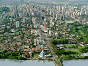
- Curitiba (Capital and largest, east)
- Londrina (2nd largest, north)
- Maringá (3rd largest, north)
- Foz do Iguaçu (4th largest, west)
- Ponta Grossa (5th largest, center-east)
- Cascavel (6th largest, center-west)
- Guarapuava (9th largest, center)
- Paranaguá (10th largest, east-coast)
Economy
The service sector is the largest component of GDP at 41.6%, followed by the industrial sector at 40%. Agriculture represents 18.4% of GDP (2004). Paraná exports: soybean 34.2%, vehicles 21.4%, wood 10%, frozen meat 8.2%, others agriculture products 8.8% (2002).
Share of the Brazilian economy: 5.9% (2005).
Its per capita GDP in 2005 was R$12,339, or US$5,400, 8th in Brazil and comparable to that of Turkey [6].
Trivia
Vehicles: 3,808,298 (March/2007); Mobile phones: 5.9 million (April/2007); Telephones: 2.7 million (April/2007); Cities: 399 (2007).[7]
Education


Portuguese is the official national language, and thus the primary language taught in schools. But English and Spanish are part of the official high school curriculum.
Educational institutions
- Centro Universitário Curitiba (UNICURITIBA);
- Centro Universitário Franciscano do Paraná (UNIFAE);
- Faculdade de Tecnologia (FATEC) (College of Technology);
- Pontifícia Universidade Católica do Paraná (PUC-PR);
- Universidade Estadual de Londrina (UEL) (State University of Londrina);
- Universidade Estadual de Maringá (UEM) (State University of Maringá);
- Universidade Estadual do Norte do Paraná (UENP) (State University of North of Paraná);
- Universidade Estadual do Oeste do Parana (Unioeste) (State University of West of Paraná)
- Universidade Estadual de Ponta Grossa (UEPG) (State University of Ponta Grossa);
- Universidade Federal do Paraná (UFPR) (Federal University of Paraná);
- Universidade Paranaense (UNIPAR)
- Universidade Positivo (Positivo University);
- Universidade Tecnológica Federal do Paraná (UTFPR);
- Universidade Tuiuti do Paraná (UTP) (Tuiuti University of Paraná);
- and many others.
Infrastructure

International airports
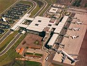
Afonso Pena International Airport is Curitiba's main airport. It is located in the nearby city of São José dos Pinhais and all commercial flights operate from this airport. It is integrated into Curitiba's transportation system, with rapid buses and executive buses connecting the airport to the city. Small aircraft may also use the Bacacheri airport, which today hosts a flight school and a national airbase.
- Foz do Iguaçu
Foz do Iguaçu International Airport. Brazil’s main airlines serve the city daily, connecting it with the rest of the country and foreign cities. Regional routes also serve local traffic. The airport is equipped for both visual and instrument operations, and has received charter flights from various continents. Its runway can serve jumbo jets such as the Boeing 747/100 and 747/200. At Foz do Iguaçu there are currently four daily flights by Varig, two by Vasp, two by Tam and one by Ocean Air. The combination of transport by highway, air, river and railway makes Foz do Iguaçu an excellent, perhaps unique, location in the Southern Cone of the Americas. Its geographic location makes it a natural port for Mercosur. In the future it also will be an obligatory port of entrance and exit of the bi-ocean central corridor.
Highways
BR-116, BR-153, BR-158, BR-163, BR-272, BR-277, BR-280, BR-369, BR-373, BR-376, BR-467, BR-469, BR-476, BR-487.
Social care
Paraná has one of the highest standards of living in Brazil with relatively low crime levels, a special attention given to education and health and a Human Development Index of ~0.820, the 5th highest in Brazil.
In October 2003 the communist government of Mr. Roberto Requião, the state governor, tried to impose to Paraná a ban in both the cultivation and transportation of genetically modified crops. This was stricter than the Brazilian standard, and eventually found unconstitutional and overruled by federal courts. The claim of Paranian farmers blocked such insane initiative and today at least 80 % of the soybeans produced on the state are OGM, and OGM corn is coming as well.
The official propaganda of Mr. Requião has tried to sell Paraná as Brazil's largest exporter of organically-grown crops.
Nevertheless, and apart of chemiophobia, the point is that agriculture in Paraná still keeping by itself his heritage of high technological grounds, being concerned today in saving precious resources, like fuel, water, land and fertilizers, as well in cleaning the atmosphere by the sequestration of carbon result of the largest no-tillage move in history. This demand well qualified and paid jobs, and the result has being an all around development of the countryside related to agriculture, with an impressive decline in poverty on the last decade.
Must be stated that this great social improvement, like all children in schools, improved healthcare, homing and standard of living of the people as all, elimination of hungry, shining cities, paved roads, all has being acquired none by gift of whatever government but by the Paranian way of doing: Working hard, being righteous, loving and protecting family and land and never expecting nothing from nowhere but his own work
Sports

Curitiba provides visitors and residents with various sport activities. There are several soccer clubs based in Curitiba, such as:
- Coritiba Foot Ball Club;
- Clube Atlético Paranaense;
- Paraná Clube.
Stadiums
- Clube Atlético Paranaense: Kyocera Arena
- Coritiba Foot Ball Club: Couto Pereira
- Paraná Clube: Vila Capanema
Curitiba is one of the 18 remaining candidates to host games of the 2014 FIFA World Cup, for which Brazil is the only South American bidder.
Album
References
- ↑ In Brazilian Portuguese. The European Portuguese pronunciation is [pɐɾɐˈna].
- ↑ Source: PNAD.
- ↑ (in Portuguese) (PDF)Síntese de Indicadores Sociais 2007. Peraná, Brazil: IBGE. 2007. ISBN 85-240-3919-1. ftp://ftp.ibge.gov.br/Indicadores_Sociais/Sintese_de_Indicadores_Sociais_2007/Tabelas. Retrieved on 2007-07-18.
- ↑ Imigrantes: Outras Etnias
- ↑ :Governo do Estado do Paraná:
- ↑ * IBGE (November 2007). "Regional Accounts 2005" (in Portuguese). Retrieved on 2007-11-26.
- ↑ Source: IBGE.
This article incorporates text from the Encyclopædia Britannica Eleventh Edition, a publication now in the public domain.
See also
- (English) Flag of Paraná
- (English) Brazil
- (Portuguese) Official Website
- (English) Brazilian Tourism Portal
- (Portuguese) Official Hotel Guide
|
||||||||||||||||||||||||||
|
|||||||||||||||||||||||||||||
|
|||||||||||||||||||||||