Pampa


| Regions of |
|---|
| Argentine Northwest |
| Gran Chaco |
| Mesopotamia |
| Cuyo |
| Pampas |
| Patagonia |
| Antártida Argentina |
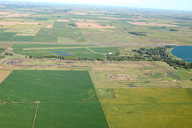
The Pampas (from Quechua, meaning "plain") are the fertile South American lowlands that include the Argentine provinces of Buenos Aires, La Pampa, Santa Fe, and Córdoba, most of Uruguay, and the southernmost end of Brazil, Rio Grande do Sul, covering more than 750,000 km2 (289,577 sq mi). These vast plains are only interrupted by the low Ventana and Tandil hills near Bahía Blanca and Tandil (Argentina), with a height of 1,300 m (4,265 ft) and 500 m (1,640 ft) respectively. The climate is mild, with precipitation of 600 mm (23.6 in) to 1,200 mm (47.2 in), more or less evenly distributed through the year, making the soils appropriate for agriculture. The average rainfall is 10 in (254 mm) to 30 in (762 mm) per year. This area is also one of the distinct physiographic provinces of the larger Parana-Paraguay Plain division. These plains contain unique wildlife due to the different terrain around it. Some of this wildlife includes the badger and praire chicken.
Frequent fires ensure that only small plants such as grasses flourish and trees are rare. The dominant vegetation types are grassy prairie and grass steppe in which numerous species of the grass genus Stipa are particularly conspicuous. "Pampas Grass" (Cortaderia selloana) is an iconic species of the Pampas. Vegetation typically includes perennial grasses and herbs. Different strata of grasses occur due to gradients of water availability. The Pampas are home to a wide variety of native species, although there is an almost absolute lack of native trees, except along main watercourses.
The World Wildlife Fund divides the Pampa into three distinct ecoregions. The Uruguayan savanna lies east of the Uruguay River, and includes all of Uruguay and the southern portion of Brazil's state of Rio Grande do Sul. The Humid Pampas include eastern Buenos Aires Province, and southern Entre Rios Province. The Semi-arid Pampas includes western Buenos Aires Province and adjacent portions of Santa Fe, Cordoba, and La Pampa provinces. The Pampas are bounded by the drier Argentine espinal grasslands, which form a semi-circle around the north, east, and south of the Humid Pampas.
Its climate, as in the mid-latitudes, is naturally changeable. Winters are cool to mild and summers are very warm and humid. Rainfall is fairly uniform throughout the year but is a little heavier during the summer. Annual rainfall is heaviest near the coast and decreases gradually further inland. Rain during the late spring and summer usually arrives in the form of brief heavy showers and thunderstorms. More general rainfall occurs the remainder of the year as cold fronts and storm systems move through. Although cold spells during the winter often send nighttime temperatures below freezing, snow is quite rare. In most winters, a few light snowfalls occur over inland areas. Snow is extremely rare near the river's coast (the so called Litoral).
Central Argentina boasts a successful agricultural business, with crops grown on the Pampas south and west of the Buenos Aires. In particular, the harvested area of soybeans is on pace to set a record, according to the Food and Agricultural Service. Much of the area is also used for grazing cattle. These farming regions (i.e., modified of disturbed Pampas) are particularly susceptible to flooding during heavy rainfall. In October 2001 an estimated 35,000 km² of the pampas were flooded. Buenos Aires reported nearly 250 mm (9.8 in) of rainfall during that month, which is more than double the normal amount.
External links

- Encyclopaedia Britannica
- The Pampas
- Encyclopedia.com
- Climate Impacts
- Centres of Plant Diversity
- Climate Guide to South America
- Humid Pampas (World Wildlife Fund)
- Semi-arid Pampas (World Wildlife Fund)
See also
- Humid Pampa
- Dry Pampa
- Pampas Republic
- Gaucho
|
||||||||||||||||||||||
|
|||||||
