Pamir Mountains
| Pamir Mountains | |
| Range | |
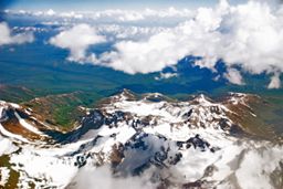
 Pamir Mountains from an airplane, June 2008
|
|
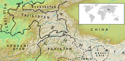
| Countries | Tajikistan, Kyrgyzstan, Afghanistan, Pakistan, China |
|---|---|
| Regions | Gorno-Badakhshan, North-West Frontier Province, Northern Areas of Pakistan, Xinjiang of China |
| Highest point | Ismail Samani Peak |
| - elevation | 7,495 m (24,590 ft) |
| - coordinates | |
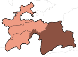
 The Pamirs are mostly in the Gorno-Badakhshan, Tajikistan
|
|
The Pamir Mountains are a mountain range located in Central Asia and are formed by the junction or knot of the Tian Shan, Karakoram, Kunlun, and Hindu Kush ranges. They are among the world’s highest mountains and in Victorian times only they were known as the 'Roof of the World', which is supposedly the meaning of the word "Pamir"[1]. . They are also known by the Chinese name of Congling 葱嶺 or 'Onion Mountains.'
The Pamir Mountains lie in Tajikistan's Gorno-Badakhshan Autonomous Province, stretching into Kyrgyzstan, Afghanistan, and China. South of Gorno-Badakhshan, the Wakhan Corridor runs through the Pamir region, which also includes the northern extremes of Pakistan's North-West Frontier Province and the Northern Areas.
Contents |
Geography
Its three highest mountains are Ismoil Somoni Peak (known from 1932–1962 as Stalin Peak, and from 1962–1998 as Communism Peak), 24,590 ft (7,495 m); Ibn Sina Peak (still unofficially known as Lenin Peak), 23,406 ft (7,134 m); and Peak Korzhenevskaya (in Russian, Pik Korzhenevskoi), 23,310 ft (7,105 m).[2]
There are many glaciers in the Pamir Mountains, including the 48-mile-long (77 km) Fedchenko Glacier, the longest in the former USSR and the longest glacier outside the Polar region.
Climate
Covered in snow throughout the year, the Pamirs have long and bitterly cold winters, and short, cool summers. Annual precipitation is about 5 inches (130 mm), which supports grasslands but few trees.
Economy
Coal is mined in the west, though sheep herding in upper meadowlands are the primary source of income for the region.
Discoveries

In the early 1980s, a deposit of gemstone-quality clinohumite was discovered in the Pamir Mountains. It was the only such deposit known until the discovery of gem-quality material in the Taymyr region of Siberia, in 2000.
Transportation
At the southeastern edge of the Pamir region in China, the Karakoram Highway, the highest international highway in the world, connects Pakistan to China. The Pamir Highway, the world's second highest, runs from Dushanbe in Tajikistan to Osh in Kyrgyzstan through the Gorno-Badakhshan Autonomous Region, and is the isolated region's main supply route. The Great Silk Road crossed a number of Pamir Mountain ranges.[3]
Strategic Position


Historically, the Pamir Mountains were considered a strategic trade route between Kashgar and Kokand on the Northern Silk Road and have been subject to numerous territorial conquests. The Northern Silk Road (about 2600 kilometres in length) connected the ancient Chinese capital of Xian to the west over the Pamir Mountains to emerge in Kashgar before linking to ancient Parthia.[4] In the 20th Century, they have been the setting for Tajikistan Civil War, border disputes between China and Soviet Union, establishment of US, Russian, and Indian military bases[5], and renewed interest in trade development and resource exploration.[6] [7]
See also
- Pamir Languages
- Wakhan
- Mountain ranges of Pakistan
- List of mountains in Pakistan
- List of mountain ranges
- List of highest mountains
- Soviet Central Asia
- Central Asia
- Mount Imeon
References
- ↑ Encyclopedia Britannica 11th ed.1911:"PAMIRS, a mountainous region of central Asia...the Bam-i-dunya ("The Roof of the World")
The Columbia Encyclopedia,1942 ed., p.1335: "Pamir (Persian =roof of the world)"
Pamirs, a region they know as POMIR – “the roof of the world" - ↑ Tajikistan: 15 Years of Independence, statistical yearbook, Dushanbe, 2006, p. 8, in Russian.
- ↑ "Official Website of Pamir Travel". Pamir Travel. Retrieved on 2007-08-03.
- ↑ Silk Road, North China, C.Michael Hogan, the Megalithic Portal, ed. A. Burnham
- ↑ "India's `Pamir Knot'". The Hindu. Retrieved on 2007-08-03.
- ↑ "The West Is Red". Time. Retrieved on 2007-08-26.
- ↑ "Huge Market Potential at China-Pakistan Border". China Daily. Retrieved on 2007-08-26.
Further reading
- Curzon, George Nathaniel. 1896. The Pamirs and the Source of the Oxus. Royal Geographical Society, London. Reprint: Elibron Classics Series, Adamant Media Corporation. 2005. ISBN 1-4021-5983-8 (pbk; ISBN 1-4021-3090-2 (hbk).
- Gordon, T. E. 1876. The Roof of the World: Being the Narrative of a Journey over the high plateau of Tibet to the Russian Frontier and the Oxus sources on Pamir. Edinburgh. Edmonston and Douglas. Reprint by Ch’eng Wen Publishing Company. Taipei. 1971.
- Toynbee, Arnold J. 1961. Between Oxus and Jumna. London. Oxford University Press.
- Wood, John, 1872. A Journey to the Source of the River Oxus. With an essay on the Geography of the Valley of the Oxus by Colonel Henry Yule. London: John Murray.
- Horsman, S. 2002. Peaks, Politics and Purges: the First Ascent of Pik Stalin in Douglas, E. (ed.) Alpine Journal 2002 (Volume 107), The Alpine Club & Ernest Press, London, pp 199-206.
- Leitner, G. W. 1890. Dardistan in 1866, 1886 and 1893: Being an Account of the History, Religions, Customs, Legends, Fables and Songs of Gilgit, Chilas, Kandia (Gabrial) Yasin, Chitral, Hunza, Nagyr and other parts of the Hindukush. With a supplement to the second edition of The Hunza and Nagyr Handbook. And an Epitome of Part III of the author’s “The Languages and Races of Dardistan”. First Reprint 1978. Manjusri Publishing House, New Delhi.
- Strong, Anna Louise. 1930. The Road to the Grey Pamir. Robert M. McBride & Co., New York.
- Slesser, Malcolm "Red Peak: A Personal Account of the British-Soviet Expedition" Coward McCann 1964
- Tilman, H. W. "Two Mountains and a River" part of "The Severn Mountain Travel Books". Diadem, London. 1983
- Waugh, Daniel C. 1999. "The ‘Mysterious and Terrible Karatash Gorges’: Notes and Documents on the Explorations by Stein and Skrine." The Geographical Journal, Vol. 165, No. 3. (Nov., 1999), pp. 306-320.
External links
- Information and photos
- The Pamirs. 1:500.000 - A tourist map of Gorno-Badkshan-Tajikistan and background information on the region. Verlag „Gecko-Maps“, Switzerland 2004 (ISBN 3-906593-35-5)
- Tourist office in Khorog (Tajikistan) Pamirs Tourism Association
| Territorial disputes in East, South, and Southeast Asia | |||
|---|---|---|---|
| Type | Territory | Currently Administered by | Claimants |
| Land: | Aksai Chin | ||
| Arunachal Pradesh | |||
| Baekdu Mountain | |||
| East Turkestan | |||
| Heixiazi/Bolshoy Ussuriysky (Eastern part)2 | |||
| Indo-Bangladesh enclaves3 | |||
| Kashmir3 | |||
| Kachin State | |||
| Kayin State | |||
| Korean Peninsula and its adjacent islands3 | |||
| Mainland China2 | |||
| Mongolia2 | |||
| Pamir Mountains (Northern and central parts)2 | |||
| Wakhan Corridor2 | |||
| Pattani | |||
| Sabah2 | |||
| Shan State | |||
| Sixty-Four Villages East of the Heilongjiang River2 | |||
| Tannu Uriankhai (now Tuva Republic of Russia)2 | |||
| Tibet | |||
| Trans-Karakoram Tract | |||
| Wa State | |||
| Islands and Waters: | Kinmen | ||
| Liancourt Rocks | |||
| Macclesfield Bank | |||
| Matsu | |||
| Paracel Islands | |||
| South Ledge | |||
| Pratas Islands | |||
| Scarborough Shoal | |||
| Senkaku Islands | |||
| Sir Creek3 | |||
| Socotra Rock | |||
| Southern Kuril Islands | |||
| Spratly Islands3 | |||
| Taiwan and Penghu2 | |||
| Notes: | 1Government in exile/exiled group. 2Inactive dispute. 3Divided among multiple claimants. |
||