Pacaya
| Pacaya | |
|---|---|
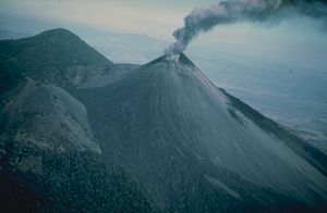 An eruption of Pacaya in 1976 |
|
| Elevation | 2,552 metres (8,373 ft) |
| Location | Guatemala |
| Type | Complex volcano |
| Last eruption | 2008 |
Pacaya is an active complex volcano in Guatemala, which first erupted approximately 23,000 years ago and has erupted at least 23 times since the Spanish conquest of Guatemala. After being dormant for a century, it erupted violently in 1965 and has been erupting continuously since then. Much of its activity is Strombolian, but occasional Plinian eruptions also occur, sometimes showering the nearby city of Antigua with ash.
Pacaya lies approximately 25 to 30 km south of Guatemala City, is easily accessible from Antigua Guatemala and Guatemala City itself, and so is a popular tourist attraction. In the late 1990s there were frequent armed robberies on its slopes, which in turn affected tourism. However, by 2006 reports of violence decreased in line with increased security efforts by the government, and Guatemalan as well as foreign tourism increased.
Contents |
Geological history
Pacaya is part of a chain of volcanoes stretching along the Pacific coast of Guatemala, formed by the subduction of the Cocos Plate underneath the Caribbean Plate. It lies on the southern edge of a sizable caldera formed in the Pleistocene age which contains Lago de Amatitlán. The caldera has been the source of at least nine very large explosions over the last 300,000 years, erupting a total of about 70 km³ of magma.
Since the last caldera-forming eruption 23,000 years ago several smaller vents within and around the caldera have seen eruptive activity. Pacaya is the largest post-caldera volcano, and has been one of Central America's most active volcanoes over the last 500 years. It has erupted at least 23 times since the Spanish conquest.
About 1,100 years ago, the volcano's edifice collapsed, causing a huge landslide. Deposits from the landslide travelled about 25 km from the volcano down to the Pacific coastal plain. The landslide left a large crater, within which the current active cone has grown. The presence of a magma chamber at shallow depths beneath Pacaya means that distortion of the cone leading to instability and future landslides remains a hazard to the surrounding areas.
Recent eruptions

With its almost continuous activity and proximity to both Guatemala City and Antigua Guatemala, the volcano has been a popular location for tourism. The volcano and surrounding area now lie within Pacaya National Park, created to manage tourism in the area and generate income from tour groups, who are charged a small fee to enter the park.
Following the end of the Guatemalan Civil War in 1996, endemic poverty and the large numbers of guns held by the general populace led to an upsurge in crime rates, and Pacaya was one of a number of popular tourist sites where armed robbery became a serious risk. Tour groups began visiting the volcano with armed guards, and incidents of robbery on the mountain have become very rare.
During 2006 a slight increase in Pacaya's volcanic activity allowed for the creation of several lava rivers that slowly flow down its slope. Word about this phenomenon spread, and local tourism increased significantly.
See also
- Central America Volcanic Arc
- List of volcanoes in Guatemala
References
- Reif S., Matias O., Rose W.I., Bluth G.J., Flynn L.P., Harris A.J. (2001) Volcanism at Pacaya, Guatemala 1985-2001: Potential of TM Images in Assessing Strombolian Activity, American Geophysical Union, Fall Meeting 2001
- Smithsonian Institution Global Volcanism Program: Pacaya
External links
- Video about Hiking the Pacaya Volcano
- Pacaya images and information from VolcanoWorld
- BBC News article about an eruption in 2000