Ouagadougou
| Ouagadougou | |
 |
|
| Nickname(s): Ouaga | |
 Ouagadougou
|
|
| Coordinates: | |
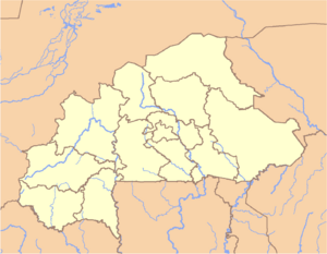
| Country | |
|---|---|
| Region | Centre Region |
| Province | Kadiogo |
| Government | |
| - Mayor | Simon Compaoré |
| Area | |
| - Metro | 1,083 sq mi (2,805 km²) |
| Population (2006-Dec-09) | |
| - City | 1,181,702 |
| - Urban | 1,181,702 |
| - Metro | 1,523,980 |
| - Metro Density | 1,406.4/sq mi (543/km²) |
Ouagadougou (IPA: /ˌwɑgəˈduːguː/, Mossi IPA: [wɑgədəgə]) is the capital of Burkina Faso and the administrative, communications, cultural and economic center of the nation. It is also the country's largest city, with a population of 1,181,702 (as of 2006)[1]. The city's name is often shortened to Ouaga.
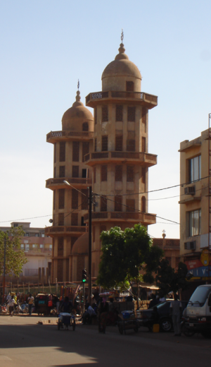
Ouagadougou's primary industries are food processing and textiles. It is served by an international airport, rail links to Abidjan in Côte d'Ivoire and to Kaya in the north of Burkina, and a highway to Niamey, Niger. Being such a focal point, there are many cinemas, nightclubs, and French, American, and Zaka cultural centers. Ouagadougou was the site of Ouagadougou grand market, one of the largest markets in West Africa, which burned in 2003 and remains closed. Other attractions include the National Museum of Burkina Faso, the Moro-Naba Palace (site of the Moro-Naba Ceremony), the National Museum of Music, and several craft markets.
Contents |
History

The name Ouagadougou goes back to the 15th century when the Yonyonse and the Ninsi tribes inhabited the area. They were in constant conflict until 1441 when Wubri, a Yonyonse hero and an important figure in Burkina Faso’s history, led his tribe to victory. He then renamed the area from “Kumbee-Tenga,” as the Ninsi had called it, to “Wogodogo,” meaning "where people get honor and respect." Ouagadougou is a corruption of Wogodogo. The spelling of the name Ouagadougou is derived from the French orthography common in former French African colonies. The country changed its name from 'Upper Volta' to Burkina Faso in the 1980's. If English orthography were used (as in Ghana or Nigeria), the spelling would be Wagadugu.[2]
Geography

Ouagadougou, situated on the central plateau (12.4° N 1.5° W), grew around the imperial palace of the Mogho Naaba. Being an administrative center of colonial rule, it became an important urban center in the post-colonial era. First the capital of the Mossi Empire and later of Upper Volta and Burkina Faso, Ouagadougou became a veritable communal center in 1995.
Government
The first municipal elections were held in 1956.
Ouagadougou is governed by a mayor, who is elected for a five-year term, two senior councillors, and 90 councillors.


The city is divided into five arrondissements, consisting of 30 sectors, which are subdivided into districts. Districts of Ouagadougou include Gounghin, Kamsaoghin, Koulouba, Moemmin, Niogsin, Paspanga, Peuloghin, Bilbalogho, and Tiendpalogo. Seventeen villages comprise the Ouagadougou metropolitan area, which is about 219.3 km².
The population of this metropolitan area is estimated to be 1,200,000 inhabitants, 48% of which are men and 52% women. The rural population is about 5% and the urban population about 95% of the total, and the density is 6,249 inhabitants per square kilometer, according to 1997 statistics.
Concerning city management, the communes of Ouagadougou have made the decision to invest in huge projects. This is largely because Ouagadougou constitutes a 'cultural centre' by merit of holding the SIAO (International Arts and Crafts fair) and the FESPACO (Panafrican Film and Television Festival of Ouagadougou). Moreover, the growing affluence of the villages allow for such investment, and the fact that the population is growing rapidly necessitates it.[2]
| Arrondissement | Population (Census 2006)[1] |
|---|---|
| Baskuy | 180,512 |
| Bogodogo | 374,473 |
| Boulmiougou | 366,182 |
| Nongremassom | 188,329 |
| Sig-Noghin | 163,859 |
Climate
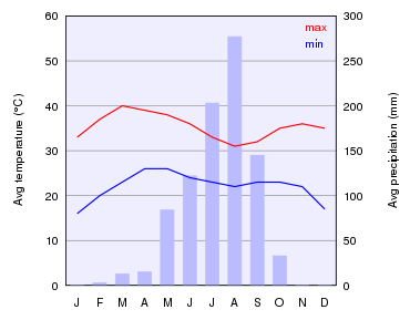
The climate of Ouagadougou is hot. The city is part of the Soudano-Sahelian area, with a rainfall of 750 mm (30 in) per year. The rainy season stretches from May to October, with an average temperature of 30 °C (86 °F). The cold season runs from December to January, with a minimum temperature of 19 °C (66 °F). The maximum temperature during the hot season, which runs from April to May, can reach 45 °C (113 °F). The harmattan (a dry wind) and the monsoon are the two main factors that determine Ouagadougou's climate."
Tourism

Parks
The Bangr-Weoogo urban park (area: 2.63 km2 (1 sq mi)), before colonialism, belonged to the Mosse chiefs. Considering it a sacred forest, many went there for traditional initiations or for refuge. The French colonists, disregarding its local significance and history, established it as a park in the 1930s. In 1985, renovations were done in the park. In January 2001, the park was renamed “Parc Urbain Bangr-Weoogo,” meaning "the urban park of the forest of knowledge."
Another notable park in Ouagadougou is the “L’Unité Pédagogique,” which shelters animals in a semi-free state. This botanic garden/biosphere system stretches over 8 hectares (20 acres) and also serves as a museum for the country’s history.
“Jardin de l’amitié Ouaga-Loudun” (Garden of Ouaga-Loudun Friendship), with a green space that was renovated in 1996, is a symbol of the twin-city relationship between Ouagadougou and Loudun in France. It is situated in the center of the city, near the “Nation Unies’ crossroads.”
Other sites

“Naba Koom” is a statue depicting a woman handling a calabash to pour water. The 6-metre (20 ft) high-statue which faces the railway station, welcoming travellers into Ouaga. The place bears the name of an important chief in Burkina Faso’s history.
“Laongo,” 30 km (19 mi) east of the city, features enormous granite slabs that were designed by sculptors. The exhibit displays works of art from five continents.[2]
“La Place du Grand Lyon” is a monument that reflects the relationship between Burkina Faso’s capital and Lyon in France. It is located near the French cultural Center George Melies and features an imposing lion.

A zoo called “Parc Animalier de Ziniaré” is located 30 km (19 mi) east of the city in the hometown of the president.
- National Museum of Music- exhibits all the musical instruments of Burkina Faso.
- “Musée de Manega,” 55 km (34 mi) northwest of the city,
Social life and education
Education
Though literacy in Ouagadougou is not high, there are ten universities in the city. The state University of Ouagadougou was founded in 1974. The official language is French and the principal local languages are More, Dyula and Fulfulde. The bilingual program in schools (French plus one of the local languages) was established in 1994.[2]
Sport, culture, and leisure
A wide array of sports, including association football, basketball, and volleyball, is played by Ouagadougou inhabitants. There are sports tournaments and activities organized by the local authorities.
There are a number of cultural and art venues, such as the Maison du Peuple and Salle des Banquets, in addition to performances of many genres of music, including traditional folk music, modern music, and rap.[2]
Art and crafts
Several international festivals and activities are organized within the municipality, such as FESPACO (Panafrican Film and Television Festival of Ouagadougou), which is Africa's largest festival of this type, SIAO (International Art and Craft Fair), FESPAM (Pan-African Music Festival), FITMO (International Theatre and Marionnette Festival) and FESTIVO.[2][3]
Practical information
Hotels and restaurants
There are four- and five-star hotels available.[4]
Health

Ouagadougou has both state and private hospitals. The two state hospitals in the city are the Centre hospitalier national Yalgado Ouedraogo (CHNYO) and the Centre hospitalier national pédiatrique Charles de Gaulle (CHNP-CDG), but there are also private hospitals. Despite that, the local population still largely trusts traditional local medicine and the “pharmacopée.”[2]
Transport
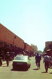
The citizens of Ouagadougou use motorcycles, bicycles and cars in preference to public transportation. The city's automobiles are generally small and inexpensively made, using a small two-stroke cycle engine. Ouagadougou's citizens also travel in green cabs, which take their passengers anywhere in town for 200 to 400 CFA, but the price is higher after 10:00 p.m. and can then reach 1000CFA. The downside is that they are slow and crowded since the drivers prefer to shuttle groups of people rather than individuals.
Ouagadougou Airport serves the area with flights to West Africa and Europe.
Sister cities

 Quebec City, Québec, Canada
 Lyon, France
- Grenoble, France
 Turin, Italy
- San Miniato, Italy
 Leuze-en-Hainaut, Belgium
 Kuwait City, Kuwait
References
- ↑ 1.0 1.1 National 2006 census preliminary results [1]
- ↑ 2.0 2.1 2.2 2.3 2.4 2.5 2.6 Commune Ouagadougou.(2005). Mairie de ouagadougou. Retrieved March 19,2006 from http://www.mairie-Ouaga.bf
- ↑ La Girafe.(2004). Ouaga-ca-bouge. Retrieved March 19, 2006 from http://www.Ouaga-ca-bouge.net
- ↑ routard.com.(2006). Burkina-Faso. Retrieved March 26,2006 from http://www.routard.com/guide/code_dest/burkina_faso.htm
External links
- Ouagadougou Official site of the government of Ouagadougou
- Ouagadougou is at coordinates
- Ouagadougou travel guide from Wikitravel
- The plan of Ouagdougou
- Burkina-Faso: Le plan de Ouagadougou.(2004). Le plan de Ouagadougou(Burkina-Faso)
|
||||||||