Opole Voivodeship
| Opole Voivodeship Województwo opolskie |
|||
| — Voivodeship — | |||
|
|||
 |
|||
 |
|||
| Coordinates(Opole): | |||
| Country | |||
|---|---|---|---|
| Capital | Opole | ||
| Counties |
1 city, 11 land counties *
|
||
| Area | |||
| - Total | 9,412.5 km² (3,634.2 sq mi) | ||
| Population (2006) | |||
| - Total | 1,044,346 | ||
| - Density | 111/km² (287.4/sq mi) | ||
| - Urban | 549,334 | ||
| - Rural | 495,012 | ||
| Car plates | O | ||
| * further divided into 71 gminas | |||
| Website: http://www.umwo.opole.pl/ | |||


Opole Voivodeship (also known as Opole Province, or by its Polish name of województwo opolskie [vɔjɛˈvut͡stfɔ ɔˈpɔlskʲɛ] or simply Opolskie; German: Woiwodschaft Oppeln/Oppelner Schlesien) is a Polish voivodeship, or province, created on January 1, 1999, out of the former Opole Voivodeship and parts of Częstochowa Voivodeship, pursuant to the 1998 Local Government Reorganization Act. The province's name derives from that of the region's capital and largest city, Opole.
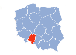
Opole Voivodeship is bordered by Lower Silesian Voivodeship to the west, Greater Poland and Łódź Voivodeships to the north, Silesian Voivodeship to the east, and the Czech Republic to the south.
Opole Province's geographic location, economic potential, and its population's level of education make it an attractive business partner for other Polish regions (especially Lower Silesian and Silesian Voivodeships) and for foreign investors. Formed in 1997, the Praděd/Pradziad Euroregion has facilitated economic, cultural and tourist exchanges between the border areas of Poland and the Czech Republic.
Contents |
Geography
The voivodeship lies in south-western Poland, the major part of it being on the Silesian Lowland (Nizina Śląska). To the east, the region touches upon the Silesian Upland (Silesian Uplands, Wyżyna Śląska) with the famous Saint Anne Mountain; the Sudetes range, the Opawskie Mountains, lies to the south-west. The Oder River cuts across the middle of the voivodeship. Northern part of the voivodeship, along the Malapanew river is densely forested, while the south is covered by arable land.
Demographics
The Opole voivodeship is the smallest region in the administrative make-up of the country in terms of both area, and population. 10% of the 1 million inhabitants of this voivodeship are ethnic Germans, which is 70% of all the ethnic Germans in Poland. (See Germans of Poland).
Transportation
The transport route from Germany to Ukraine runs through Opole. The region has four border crossings and direct rail connections to all important Polish cities, as well as to Frankfurt, Munich, Budapest, Kiev, and the Baltic ports.
Cities and towns
The voivodeship contains 35 cities and towns. These are listed below in descending order of population (according to official figures for 2006 [1]):
|
1. Opole (128,034) |
19. Niemodlin (6,849) |
Administrative division
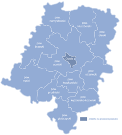
Opole Voivodeship is divided into 12 counties (powiats): 1 city county and 11 land counties. These are further divided into 71 gminas.
The counties are listed in the following table (ordering is by decreasing population).
| English and Polish names |
Area (km²) |
Population (2006) |
Seat | Other towns | Total gminas |
| City counties | |||||
| Opole | 96 | 128,034 | 1 | ||
| Land counties | |||||
| Nysa County powiat nyski |
1,224 | 145,640 | Nysa | Głuchołazy, Paczków, Otmuchów, Korfantów | 9 |
| Opole County powiat opolski |
1,587 | 134,874 | Opole * | Ozimek, Niemodlin, Prószków | 13 |
| Kędzierzyn-Koźle County powiat kędzierzyńsko-kozielski |
625 | 102,118 | Kędzierzyn-Koźle | 6 | |
| Brzeg County powiat brzeski |
877 | 92,361 | Brzeg | Grodków, Lewin Brzeski | 6 |
| Strzelce County powiat strzelecki |
744 | 80,828 | Strzelce Opolskie | Zawadzkie, Kolonowskie, Leśnica, Ujazd | 7 |
| Kluczbork County powiat kluczborski |
852 | 70,082 | Kluczbork | Wołczyn, Byczyna | 4 |
| Olesno County powiat oleski |
974 | 68,269 | Olesno | Praszka, Dobrodzień, Gorzów Śląski | 7 |
| Krapkowice County powiat krapkowicki |
442 | 67,926 | Krapkowice | Zdzieszowice, Gogolin | 5 |
| Prudnik County powiat prudnicki |
571 | 59,931 | Prudnik | Głogówek, Biała Prudnicka | 4 |
| Głubczyce County powiat głubczycki |
673 | 50,326 | Głubczyce | Kietrz, Baborów | 4 |
| Namysłów County powiat namysłowski |
748 | 43,957 | Namysłów | 5 | |
| * seat not part of the county | |||||
Economy
The Opole voivodeship is an industrial as well as an agricultural region. With respect to mineral resources, of major importance are deposits of raw materials for building: limestone (Strzelce Opolskie), marl (near Opole), marble, and basalt. The favourable climate, fertile soils, and high farming culture contribute to the development of agriculture, which is among the most productive in the country.
A total of nineteen industries are represented in the voivodeship. The most important are cement and lime, furniture, food, car manufacturing, and chemical industries. In 1997, the biggest production growth in the area was in companies producing wood and wood products, electrical equipment, machinery and appliances, as well as cellulose and paper products. In 1997, the top company in the region was Zakłady Azotowe S.A. in Kędzierzyn-Koźle, whose income was over PLN 860 million. The voivodship's economy consists of more than 53,000 businesses, mostly small and medium-sized, employing over 332,000 people. Manufacturing companies employ over 89,000 people; 95.7% of all the region's business operate in the private sector.
Universities
There are three state-run universities in the region: the Opole University, the Opole University of Technology, and the State Medical College. All of them are based in the voivodeship's capital. Among the region's private schools, the Opole School of Management and Administration has been certified as a degree-granting institution by the Ministry of National Education.
- Opole University of Technology
- Opole University
- State Medical College
- Opole School of Management and Administration
- Bogdan Jański College
- The State Higher Vocational School in Nysa, PWSZ in NYSA
Tourism

The Opole voivodeship is a green region with three large lakes: Turawskie, Nyskie, and Otmuchowskie (the latter two are connected). The Opawskie Mountains are extremely popular. The region also includes the castle in Brzeg, built during the reign of the Piast dynasty — pearl of the Silesian Renaissance, the Franciscan monastery on top of Saint Anne Mountain, as well as the mediæval defence fortifications in Paczkow (referred to as the Polish Carcassonne).
The region has the warmest climate in the country.
Protected areas in Opole Voivodeship include the following three areas designated as Landscape Parks:
- Opawskie Mountains Landscape Park
- Góra Świętej Anny Landscape Park
- Stobrawa Landscape Park
Most popular surnames in the region
- Nowak: 5,538
- Wieczorek: 2,654
- Mazur: 2,512
Previous Opole voivodeships

Opole Voivodeship was also a unit of administrative division and local government in Poland between 1975 and 1998.
Major cities and towns — (population in 1995):
- Opole, capital city (130,600)
- Kędzierzyn-Koźle (70,700)
- Nysa (49,000)
- Brzeg (39,900)
- Kluczbork (26,900)
- Prudnik (24,300)
- Strzelce Opolskie (21,900)
- Krapkowice (20,100)
Opole Voivodeship (1950–1975)
This administrative region of the People's Republic of Poland (1950–1975) was created as a result of the partition of Katowice Voivodeship in 1950.
External links
- Opolskie - photogallery
- Self-Government of the Opolskie Voivodeship
- Opolski Urząd Wojewódzki Official website
|
||||||||||
|
|||||||