Northern line
| Northern | |||||||||||||||||||||||||||||||||
|---|---|---|---|---|---|---|---|---|---|---|---|---|---|---|---|---|---|---|---|---|---|---|---|---|---|---|---|---|---|---|---|---|---|
| Colour on map | Black | ||||||||||||||||||||||||||||||||
| Year opened | 1890 | ||||||||||||||||||||||||||||||||
| Line type | Deep Tube | ||||||||||||||||||||||||||||||||
| Rolling stock | 1995 Tube Stock | ||||||||||||||||||||||||||||||||
| Stations served | 50 | ||||||||||||||||||||||||||||||||
| Length | 58 km (36 mi) | ||||||||||||||||||||||||||||||||
| Depots | Golders Green Morden Highgate Edgware High Barnet |
||||||||||||||||||||||||||||||||
| Journeys made | 206,734,000 (per annum) | ||||||||||||||||||||||||||||||||
| Rail lines of Transport for London |
|||||||||||||||||||||||||||||||||
|
|||||||||||||||||||||||||||||||||
The Northern line is a deep-level tube line on the London Underground, coloured black on the Tube map. It carries more passengers per year than any other Underground line; 206,734,000 passengers per annum. Despite its name, the Northern line does not serve the northernmost stations on the Underground network although, ironically, it does serve the southernmost station and serves 16 of the Underground system's 29 stations south of the River Thames: a proportion higher than any other line. Of the 50 stations on the Northern line, 36 are underground.
The line has a complicated history and the current complex arrangement of two northern branches, two central branches and the southern branch reflects its genesis as three separate railway companies that were brought together and combined in the 1920s and 1930s. An extension in the 1920s used a route originally planned by a fourth company and abandoned plans to extend the line southwards in the 1920s and northwards in the 1930s would have incorporated parts of the routes of a two further companies. From the 1930s to the 1970s, the tracks of a seventh company were also managed as a branch of the Northern Line.[1]
Contents |
History
Formation
- See City and South London Railway and Charing Cross, Euston and Hampstead Railway for detailed histories of these companies

The core of the Northern line evolved from two railway companies – the City & South London Railway (C&SLR) and the Charing Cross, Euston & Hampstead Railway (CCE&HR).
The C&SLR, London's first deep-level tube railway, was built under the supervision of James Henry Greathead, who had been responsible, with Peter W. Barlow, for the Tower Subway. It was the first of the Underground's lines to be constructed by boring deep below the surface and the first to be operated by electric traction. The railway opened in November 1890 from Stockwell to a now-disused station at King William Street. This was inconveniently placed and unable to cope with the company's traffic, so, in 1900, a new route to Moorgate via Bank was opened. By 1907 the C&SLR had been further extended at both ends to run from Clapham Common to Euston.
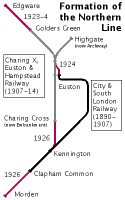
The CCE&HR (commonly known as the "Hampstead Tube") was opened in 1907 and ran from Charing Cross (known for many years as Strand) via Euston and Camden Town (where there was a junction) to Golders Green and Highgate (now known as Archway). It was extended south by one stop to Embankment in 1914 to form a interchange with the Bakerloo line and the District line. In 1913, the Underground Electric Railways Company of London Limited (UERL), owner of the CCE&HR, took over the C&SLR although they remained separate companies.
Integration
During the early 1920s, a series of works were carried out to connect the C&SLR and CCE&HR tunnels to enable an integrated service to be operated. The first of these new tunnels between the C&SLR's Euston station and the CCE&HR's station at Camden Town, had originally been planned in 1912[2] but had been delayed by World War I. The second connection linked the CCE&HR's Embankment and C&SLR's Kennington stations and provided a new intermediate station at Waterloo to connect to the Mainline station and Bakerloo line. The smaller diameter tunnels of the C&SLR were also expanded to match the standard diameter of the CCE&HR and the other deep tube lines.
Extensions
In conjunction with the works to integrate the two lines, two major extensions were undertaken; northwards to Edgware in Middlesex (now in the London Borough of Barnet) and southwards to Morden in Surrey (now in the London Borough of Merton).
Edgware extension
The Edgware extension utilised unused plans dating back to 1901 for the Edgware and Hampstead Railway (E&HR)[3] which the UERL had taken over in 1912. It extended the CCE&HR line from its terminus at Golders Green to Edgware in two stages - to Hendon Central in 1923 and to Edgware in 1924. The line crossed undeveloped open countryside and, apart from a short tunnel north of Hendon Central, was on the surface. Five new stations were constructed to pavilion-style designs by Stanley Heaps, stimulating the rapid northward expansion of suburban developments in the following years.
Morden extension
The engineering of the Morden extension of the C&SLR from Clapham Common to Morden was more demanding, running in tunnel to a point just north of Morden station which was constructed in a cutting. The extension was initially planned to continue to Sutton[4] over part of the route for the unbuilt Wimbledon and Sutton Railway, in which the UERL held a stake, but agreements were made with the Southern Railway to end the extension at Morden. The extension opened in 1926 with seven new stations, all designed by Charles Holden in a modern style. With the exception of Morden and Clapham South, where more land was available, the new stations were built on confined corner sites at main road junctions in already developed areas. Holden made good use of this limited space and designed impressive buildings. The street-level structures are of white Portland stone with tall double-height ticket halls, with the famous London Underground roundel made up in coloured glass panels in large glazed screens. The stone columns framing the glass screens are surmounted by a capital formed as a three-dimensional version of the roundel. The large expanses of glass ensure that the ticket halls are bright and, lit from within at night, welcoming. The first and last new stations on the extension, Morden and Clapham South, include a parade of shops and were designed with structures capable of being built above (like many of the earlier central London stations). Clapham South was extended upwards soon after its construction with a block of apartments; Morden was extended upwards in the 1960s with a block of offices. All the stations on the extension, except Morden itself, are Grade II listed buildings.
Naming
The resulting line became known as the Morden–Edgware line, although a number of alternative names were also mooted in the fashion of the contraction of Baker Street & Waterloo Railway to "Bakerloo", such as "Edgmor", "Mordenware", "Medgway" and "Edgmorden".[5] It was eventually named the Northern line in 1937.
Ironically, when the 'Northern' line was so named, it actually had more stations located South of the river than any other line on the network, and this remains the case today.
Great Northern & City Railway
After the UERL and the Metropolitan Railway (MR) were brought under public control in the form of the London Passenger Transport Board (LPTB) in 1933, the MR's subsidiary, the Great Northern & City Railway, which ran from Moorgate to Finsbury Park, became part of the Underground as the Northern City Line. In preparation for the Northern Heights Plan, it was operated as part of the Northern line, although it was never connected to it.
The Northern Heights plan
- See Edgware, Highgate and London Railway for a detailed history of that company

In June 1935, the LPTB announced the New Works Programme, an ambitious plan to expand the Underground network which included the integration of a complex of existing London and North Eastern Railway (LNER) lines north of Highgate through the "Northern Heights". These lines, built in the 1860s and 1870s by the Edgware, Highgate and London Railway (EH&LR) and its successors, ran from Finsbury Park to Edgware via Highgate, with branches to Alexandra Palace and High Barnet. The line taken over would be extended beyond Edgware to Brockley Hill, Elstree South and Bushey Heath with a new depot at Aldenham. The extension's route was that planned for the unbuilt Watford and Edgware Railway (W&ER), using rights obtained from the earlier purchase of the W&ER (which had long-intended an extension of the EH&LR Edgware route towards Watford). This also provided the potential for further extension in the future if required; indeed, Bushey's town planners reserved space in Bushey village for a future station and Bushey Heath station's design was revised several times to ensure this option would remain available in the future.
The project involved electrification of the surface lines (operated by steam trains at the time), the doubling of the original single-line section between Finchley Central and the proposed junction with the Edgware branch of the Northern line, and the construction of three new linking sections of track: a connection between Northern City line and Finsbury Park station on the surface; an extension from Archway to the LNER line near East Finchley via new deep-level platforms below Highgate station; and a short diversion from just before the LNER's Edgware station to the Underground's station of the same name.
Intended service levels
The peak hours service levels would have seen 21 trains per hour each way on the Barnet branch north of Camden Town, 14 via Leicester Square branch and 7 via Bank branch. Of those 14 would have continued on beyond Finchley Central, 7 each on the High Barnet and Edgware branches. An additional 7 trains per hour would have served the Barnet branch, but continued via Highgate High-Level and Finsbury Park to Moorgate, a slightly shorter route to the City. It does not seem to have been intended to run through trains to the ex-Northern City branch from Edgware via Finchley Central. 7 trains per hour would have served the Alexandra Palace branch, to/from Moorgate via Highgate High-level. In addition to the 14 through trains described, the ex-Northern City branch would have 14 4-car shuttles per hour.
Progress of works
Work began in the late 1930s, and were in active progress on all fronts by the outbreak of the World War II. The tunneling northwards from the original Highgate station (now Archway) had been completed and the service to the rebuilt surface station at East Finchley started on 3 July 1939, but without the opening of the intermediate (new) Highgate Station, at the site of the LNER's station of the same name. Further progress was disrupted by the start of the war, though enough had been made to complete the electrification of the High Barnet branch onwards from East Finchley over which tube services started on 14 April 1940; the new (deep-level) Highgate station finally opened on 19 January 1941. The single track LNER line to Edgware was electrified as far as Mill Hill East, opening as a tube service on 18 May 1941 to serve the barracks there, thus forming the Northern line as it is today. The new depot at Aldenham had already been built and was used to build Halifax bombers. Work on the other elements of the plan was suspended late in 1939.
Preparatory work including viaducts and a tunnel had been started but not completed on the Bushey extension pre-war. After the war, however, the area beyond Edgware was made part of the Green Belt largely preventing the anticipated residential development in the area and the potential demand for services from Bushey Heath thus vanished. Available funds were directed towards completing the eastern extension of the Central line instead, and the Northern Heights plan was dropped on 9 February 1954. Aldenham depot was converted into an overhaul facility for buses.
The implemented service from High Barnet branch gave good access both to the West End and the City. This appears to have undermined traffic on the Alexandra Palace branch still run with steam haulage to Kings Cross via Finsbury Park, as Highgate (Low-level) was but a short bus ride away and car traffic was much lighter than it would become later. Consequently, the line from Finsbury Park to Muswell Hill and Alexandra Palace via the surface platforms at Highgate was closed altogether to passenger traffic in 1954. This contrasts with the decision to electrify the Epping-Ongar branch of the Central line, another remnant of the New Works programme, run as a tube train shuttle from 1957. A local pressure group, the Muswell Hill Metro Group, campaigns to reopen this route as a light rail service. So far there is no sign of movement on this issue; the route, now the Parkland Walk, is highly valued by walkers and cyclists and suggestions in the 1990s that it could, in part, become a road were met with fierce opposition.
The rural railway heritage of the High Barnet branch beyond Highgate can be seen in the design of many of the stations.
Infrastructure
Rolling Stock

All Northern line trains consist of London Underground 1995 Stock and are in the distinctive Underground livery of red, white and blue. In common with the other deep-level lines, the trains are the smaller of the two sizes used on Underground. The 1995 stock is quite comfortable when compared to the older stock used on other lines. 1995 stock sports automated announcements and quick-close doors. Bicycles are only allowed on trains to High Barnet after East Finchley (including the Mill Hill East branch). They are also allowed between Golders Green and Edgware, but not between Hendon Central and Colindale[6].

Map

The TFL line diagram is available online.
Stations
| Northern line | |||||||||||||||||||||||||||||||||||||||||||||||||||||||||||||||||||||||||||||||||||||||||||||||||||||||||||||||||||||||||||||||||||||||||||||||||||||||||||||||||||||||||||||||||||||||||||||||||||||||||||||||||||||||||||||||||||||||||||||||||||||||||||||||||||||||||||||||||||||||||||||||||||||||||||||||||||||||||||||||||||||||||||||||||||||||||||||||||||||||||||||||||||||||||||||||||||||||||||||||||||||||||||||||||||||||||||||||||||||||||||||||||||||||||||||||||||||||||||||||||||||||||||||||||||||||||||||||||||||||||||||||||||||||||||||||||||||||||||||||||||||||||||||||||||||||||||||||||||||||||||||||||||||||||||||||||||||||||||||||||||||||||||||||||||||||||||||||||||||||||||||||||||||||||||||||||||||||||||||||||||||||||||||||||||||||||||||||||||||||||||||||||||||||||||||||||||||||||||||||||||||||||||||||||||||||||||||||||||||
|---|---|---|---|---|---|---|---|---|---|---|---|---|---|---|---|---|---|---|---|---|---|---|---|---|---|---|---|---|---|---|---|---|---|---|---|---|---|---|---|---|---|---|---|---|---|---|---|---|---|---|---|---|---|---|---|---|---|---|---|---|---|---|---|---|---|---|---|---|---|---|---|---|---|---|---|---|---|---|---|---|---|---|---|---|---|---|---|---|---|---|---|---|---|---|---|---|---|---|---|---|---|---|---|---|---|---|---|---|---|---|---|---|---|---|---|---|---|---|---|---|---|---|---|---|---|---|---|---|---|---|---|---|---|---|---|---|---|---|---|---|---|---|---|---|---|---|---|---|---|---|---|---|---|---|---|---|---|---|---|---|---|---|---|---|---|---|---|---|---|---|---|---|---|---|---|---|---|---|---|---|---|---|---|---|---|---|---|---|---|---|---|---|---|---|---|---|---|---|---|---|---|---|---|---|---|---|---|---|---|---|---|---|---|---|---|---|---|---|---|---|---|---|---|---|---|---|---|---|---|---|---|---|---|---|---|---|---|---|---|---|---|---|---|---|---|---|---|---|---|---|---|---|---|---|---|---|---|---|---|---|---|---|---|---|---|---|---|---|---|---|---|---|---|---|---|---|---|---|---|---|---|---|---|---|---|---|---|---|---|---|---|---|---|---|---|---|---|---|---|---|---|---|---|---|---|---|---|---|---|---|---|---|---|---|---|---|---|---|---|---|---|---|---|---|---|---|---|---|---|---|---|---|---|---|---|---|---|---|---|---|---|---|---|---|---|---|---|---|---|---|---|---|---|---|---|---|---|---|---|---|---|---|---|---|---|---|---|---|---|---|---|---|---|---|---|---|---|---|---|---|---|---|---|---|---|---|---|---|---|---|---|---|---|---|---|---|---|---|---|---|---|---|---|---|---|---|---|---|---|---|---|---|---|---|---|---|---|---|---|---|---|---|---|---|---|---|---|---|---|---|---|---|---|---|---|---|---|---|---|---|---|---|---|---|---|---|---|---|---|---|---|---|---|---|---|---|---|---|---|---|---|---|---|---|---|---|---|---|---|---|---|---|---|---|---|---|---|---|---|---|---|---|---|---|---|---|---|---|---|---|---|---|---|---|---|---|---|---|---|---|---|---|---|---|---|---|---|---|---|---|---|---|---|---|---|---|---|---|---|---|---|---|---|---|---|---|---|---|---|---|---|---|---|---|---|---|---|---|---|---|---|---|---|---|---|---|---|---|---|---|---|---|---|---|---|---|---|---|---|---|---|---|---|---|---|---|---|---|---|---|---|---|---|---|---|---|---|---|---|---|---|---|---|---|---|---|---|---|---|---|---|---|---|---|---|---|---|---|---|---|---|---|---|---|---|---|---|---|---|---|---|---|---|---|---|---|---|---|---|---|---|---|---|---|---|---|---|---|---|---|---|---|---|---|---|---|---|---|---|---|---|---|---|---|---|---|---|---|---|---|---|---|---|---|---|---|---|---|---|---|---|---|---|---|---|---|---|---|---|---|---|---|---|---|---|---|---|---|---|---|---|---|---|---|---|---|---|---|---|---|---|---|---|---|---|---|---|---|---|---|---|---|---|---|---|---|---|---|---|---|---|---|---|---|---|---|---|---|---|---|---|---|---|---|---|---|---|---|---|---|---|---|---|---|---|---|---|---|---|---|---|---|---|---|---|---|---|---|---|---|---|---|---|---|---|---|---|---|---|---|---|---|---|---|---|---|---|---|---|---|---|---|---|---|---|---|---|---|---|---|---|---|---|---|---|---|---|---|---|---|---|---|---|---|---|---|---|---|---|---|---|---|---|---|---|---|---|---|---|---|---|---|---|---|---|---|---|---|---|---|---|---|---|---|---|---|---|---|---|---|---|---|---|---|---|---|---|
|
|||||||||||||||||||||||||||||||||||||||||||||||||||||||||||||||||||||||||||||||||||||||||||||||||||||||||||||||||||||||||||||||||||||||||||||||||||||||||||||||||||||||||||||||||||||||||||||||||||||||||||||||||||||||||||||||||||||||||||||||||||||||||||||||||||||||||||||||||||||||||||||||||||||||||||||||||||||||||||||||||||||||||||||||||||||||||||||||||||||||||||||||||||||||||||||||||||||||||||||||||||||||||||||||||||||||||||||||||||||||||||||||||||||||||||||||||||||||||||||||||||||||||||||||||||||||||||||||||||||||||||||||||||||||||||||||||||||||||||||||||||||||||||||||||||||||||||||||||||||||||||||||||||||||||||||||||||||||||||||||||||||||||||||||||||||||||||||||||||||||||||||||||||||||||||||||||||||||||||||||||||||||||||||||||||||||||||||||||||||||||||||||||||||||||||||||||||||||||||||||||||||||||||||||||||||||||||||||||||||
High Barnet branch
- High Barnet
- Totteridge and Whetstone
- Woodside Park

- West Finchley
- Mill Hill East (shuttle trains to and from Finchley Central)
- Finchley Central
- East Finchley
- Highgate
- Archway
- Tufnell Park
- Kentish Town

Edgware branch
- Edgware
- Burnt Oak
- Colindale
- Hendon Central
- Brent Cross
- Golders Green
- Hampstead
- Belsize Park
- Chalk Farm
Camden Town
- Camden Town
The junctions connecting the two northern branches of the Northern line to the two central branches are just south of Camden Town station. The station has a pair of platforms on each of the two northern branches, and southbound trains can depart toward either Charing Cross or Bank from either of the two southbound platforms.
Charing Cross branch
(Also known as the West End branch.)
- Mornington Crescent
- Euston

- Warren Street
- Goodge Street
- Tottenham Court Road
- Leicester Square
- Charing Cross
- Embankment (
 Embankment Pier)
 - Waterloo ( Waterloo Pier, Festival Pier)
Southbound trains on this branch often terminate at Kennington, which has a terminal loop.
Bank branch
(Also known as the City Branch.)
- Euston
- King's Cross St Pancras (
 Trains to Gatwick and Luton)
 - Angel
- Old Street
- Moorgate
- Bank

- London Bridge ( Trains to Gatwick and Luton) ( London Bridge City Pier)
- Borough
- Elephant and Castle
Morden branch
- Kennington
- Oval
- Stockwell
- Clapham North
- Clapham Common
- Clapham South
- Balham
- Tooting Bec
- Tooting Broadway
- Colliers Wood
- South Wimbledon
- Morden
Closed Stations
- King William Street (closed 1900)
- City Road (closed 1922)
- South Kentish Town (closed 1924)
- North End (never opened work stopped 1906)
Resited Stations
- Stockwell - new platforms resited immediately to the south of its predecessor with the 1922-1924 upgrade of the line.
- Euston - Northbound platform resited on new alignment, with previous island platform converted to a single platform
- Angel - old island platform converted into a single platform, and a new alignment opened in 1992, along with a new entrance.
Abandoned Plans
Northern Heights stations not transferred from LNER
- Stroud Green
- Crouch End
- Cranley Gardens
- Muswell Hill
- Alexandra Palace
- Mill Hill
Bushey Extension stations not constructed
- Brockley Hill
- Elstree South
- Bushey Heath
Gallery
Recent developments
In 1975, the Northern City Line, known by that time as the Highbury branch, became part of British Rail; it is now served by First Capital Connect.
In the 1980s and 1990s the line was nicknamed the "Misery Line",[7][8] though its reputation improved somewhat after the introduction of the 1995 stock.
In 2003, a train derailed at Camden Town. This damaged points and signals and the junctions there were not used while repairs were underway — trains coming from Edgware worked the Bank branch only, and trains from High Barnet and Mill Hill East the Charing Cross branch only. This situation was resolved when the junctions reopened, after much repair work and safety analysis and testing, on 7 March 2004.
A joint report by the Underground and its maintenance contractor Tube Lines concluded that poor track geometry was the main cause, and that, because of the geometry, extra friction arising out of striations (scratches) on a newly installed set of points had allowed the leading wheel of the last carriage to climb the rail and so derail. The track geometry at the derailment site is a very tight bend and tight tunnel bore, which precludes the normal solution for this sort of geometry of canting the track by raising the height of one rail relative to the other.
On 7 July 2005, a defective train on the Northern line (causing its subsequent suspension) saved the Northern line from the London Bombings on that day. Three trains on the Circle and Piccadilly lines were not so lucky. The fourth bomber instead boarded a bus, which he later blew up.
On 13 October 2005, the entire Northern line service was suspended due to maintenance problems with the emergency braking system on the trains[9]. A series of rail replacement buses was used to connect outlying stations with other Underground lines[10]. A reduced service was reintroduced on 17 October 2005, and full service was restored on 18 October.
In October 2006, service to/from Mill Hill East was cut back to a shuttle, except during peak hours, and a few weekend trains.
From June 2006, the service between East Finchley and Camden Town has been suspended for two non-consecutive weeks every month, with service on the Edgware branch suspended for the other two weeks. This is part of Tube Lines redevelopment of some Edgware and High Barnet Branch stations, including replacement of track, signals, as well as station maintenance[11]. This includes refurbishment of all High Barnet branch stations running from West Finchley tube station down to Camden Town tube station.
Future
TfL's Transport 2025 - Transport vision for a growing world [12] confirms their ambition to split the Northern line into two segregated routes. Running trains between all combinations of branches, as is currently done, means only 22-25 trains per hour can run on each of the central sections, because merging trains have to wait for each other at the junctions. Segregating the routes will allow 30 trains per hour on all parts of the system. However, Camden Town tube station would need to be rebuilt before this could be implemented, as the current station would not be able to cope with the increased number of passengers changing trains there. LUL have however had problems gaining planning permission for the redevelopment plans[13].
Splitting the line operationally in two could lead to one or both being renamed and given a different colour on the tube map. All trains on the Charing Cross branch would terminate at Kennington, and it has long been suggested that the line could be extended from there to points southeast.
The Northern line is scheduled to switch to automatic train operation in 2011, using the same SelTrac system that will be introduced on the Jubilee line in 2009, and that is already in use on the Docklands Light Railway.[14]
The Thameslink Programme upgrade should relieve congestion on the Northern Line by transferring passengers to heavy rail services.
In June 2008, Treasury Holdings, owners of Battersea Power Station, announced proposals for an extension of the Northern line from Kennington to a station in Battersea to serve a redeveloped power station site. If approved and funded, the extension could be opened by 2015, as part of a planned re-development of the Battersea Power Station.[15]
Notes and References
- ↑ The seven companies were 1. the City & South London Railway, 2. the Charing Cross, Euston & Hampstead Railway, 3. the Edgware, Highgate & London Railway, 4. the Edgware & Hampstead Railway, 5. the Watford & Edgware Railway, 6. The Wimbledon & Sutton Railway and 7. the Great Northern & City Railway.
- ↑ London Gazette: no. 28665, page 8798, 1912-11-22. Retrieved on 2008-07-21.
- ↑ London Gazette: no. 27380, page 8200, 1901-11-26. Retrieved on 2008-07-21.
- ↑ London Gazette: no. 32770, pages 8314–8315, 1922-11-24. Retrieved on 2008-07-21.
- ↑ Wolmar, Christian (2004). "Reaching Out". The Subterranean Railway: How the London Underground Was Built and How It Changed the City Forever. Atlantic Books. pp. p. 225. ISBN 1-84354-023-1.
- ↑ "Bicycle Tube Map" (PDF). Transport for London (January 2008). Retrieved on 2008-06-30.
- ↑ "Call for action on Northern Line". BBC News (2005-10-12). Retrieved on 2008-06-10.
- ↑ "Five more years of Northern line pain". This Is Local London (2006-09-11). Retrieved on 2008-08-26.
- ↑ "Travel Delays as Tube Line Shut", BBC News (2005-10-13). Retrieved on 2008-06-30.
- ↑ "No Service on the Northern Line". Transport for London (2005-10-13). Retrieved on 2008-06-30.
- ↑ "Map of Upgrades" (PDF). Tube Lines. Retrieved on 2008-06-30.
- ↑ "Transport 2025 - Transport Vision for a Growing World" (PDF). Transport for London (2006-11-11). Retrieved on 2008-07-21.
- ↑ "Camden Town Redevelopment". Alwaystouchout.com (2006-01-25). Retrieved on 2008-06-30.
- ↑ "Network Tests for New Signalling Systems", Tube Lines (2008-07-21).
- ↑ Rowson, Jessica (2008-06-26). "Battersea Power Station's £4bn plan to hinge on Tube extension", New Civil Engineer. Retrieved on 2008-07-06.
See also
- Leslie Green, architect of the Charing Cross, Euston and Hampstead Railway's early stations
- London deep-level shelters, most of which are under Northern line stations
- N5 night bus
- N20 night bus
External links
- "Northern line facts". Transport for London. Retrieved on 2008-07-11.
- "Northern Line". Clive's Underground Line Guides (2008-02-07). Retrieved on 2008-07-11.
- Muswell Hill Metro Group
- Northern line Route for the freeware train simulator BVE Trainsim
- "Northern Heights". Underground History (2005-02-23). Retrieved on 2008-07-11.
| West: | Crossings of the River Thames | East: |
|---|---|---|
| Hungerford Bridges | Charing Cross branch, between Embankment and Waterloo |
Waterloo Bridge |
| London Bridge | City branch, between Bank and London Bridge |
Tower Subway |