Northamptonshire
| Northamptonshire | |
|---|---|
 |
|
 |
|
| Geography | |
| Status | Ceremonial & Non-metropolitan county |
| Region | East Midlands |
| Area - Total - Admin. council |
Ranked 24th 2,364 km² (913 sq mi) Ranked 22nd |
| Admin HQ | Northampton |
| ISO 3166-2 | GB-NTH |
| ONS code | 34 |
| NUTS 3 | UKF23 |
| Demography | |
| Population - Total (2007 est.) - Density - Admin. council |
Ranked 33rd 678,200 287/km² (743/sq mi) Ranked 16th |
| Ethnicity | 95.1% White 2.0% S.Asian 1.2% Black British. |
| Politics | |
Northamptonshire County Council http://www.northamptonshire.gov.uk/ |
|
| Executive | Conservative |
| Members of Parliament | |
| Districts | |
|
|
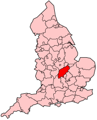
Northamptonshire (or, archaically, the County of Northampton; pronounced /nɔrˈθæmptənʃər/ or /nɔrθˈhæmptənʃɪər/; abbreviated Northants. or N/hants) is a landlocked county in the English East Midlands, with a population of 629,676 as at the 2001 census. It has boundaries with Warwickshire, Leicestershire, Rutland, Cambridgeshire (including the city of Peterborough), Bedfordshire, Buckinghamshire (including the borough of Milton Keynes), Oxfordshire, and Lincolnshire (England's shortest county boundary at 19 metres). The county town is Northampton.
Northamptonshire has often been called the county of "squires and spires" due to its wide variety of historic buildings and country houses. The county has also been described as "England's Pancreas", most notably by the popular presenter Alan Titchmarsh in his 2007 series The Nature of Britain. This is due to its shape and location within the UK, and because it is regularly overlooked, especially compared to neighbouring Warwickshire, known as "The Heart of England".
Northamptonshire's county flower is the cowslip.
Contents |
Geography
By the standards of the English Midlands, Northamptonshire is an upland county. It includes the watershed between the Severn and The Wash. Several important rivers have their sources in the north west of the county: these include the River Nene (to The Wash) and the "Warwickshire Avon" (to the Severn). In the 1820s it was boasted that "not a single brook, however insignificant, flows into it from any other district". The highest point in the county is nevertheless the modest Arbury Hill at 225 m (738 ft).
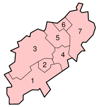
Northampton is the largest town in the county, with a population of 194,122. This is followed by Kettering (51,063), Corby (49,222), Wellingborough (46,959 ), Rushden (25,849) and Daventry (22,367). Most of the county's population is concentrated in a central north–south band which includes the four largest towns (corresponding to districts 2, 4, 5 & 6 on the map). The west (districts 1 & 3) and east (district 7) are predominantly rural with small towns and many villages. Northamptonshire is a long, thin county (more so with the Soke of Peterborough), running from south-west to north-east.
Places
These are the main settlements in Northamptonshire with a town charter, a population over 5,000, or otherwise notable. For a complete list of settlements see List of places in Northamptonshire
- Brackley
- Brixworth
- Burton Latimer
- Corby
- Daventry
- Desborough
- Higham Ferrers
- Irthlingborough
- Kettering
- Northampton
- Oundle
- Raunds
- Rothwell
- Rushden
- Towcester
- Thrapston
- Wellingborough
Peterborough
The Soke of Peterborough was historically associated with Northamptonshire, as the county diocese is focused upon the cathedral there. However, it had its own county council, and in 1965 was merged with the neighbouring small county of Huntingdonshire.[1] Under the Local Government Act 1972 the city of Peterborough became a district of Cambridgeshire.[2]
History
Main article History of Northamptonshire
Pre-Celtic and Celtic peoples settled in the region, and there are some traces of Roman settlements and roads. Most notably the Watling Street passed through the county, and there was an important Roman settlement called Lactodorum on the site of modern-day Towcester. There were other Roman settlements at the site of Northampton, and along the Nene Valley near Raunds.
After the Romans left, the area became part of the Anglo-Saxon kingdom of Mercia, and Northampton functioned as an administrative centre. The area was overrun by the Danes (Vikings) in the 9th century and briefly became part of the Danelaw, but was later re-claimed by the Saxons. Consequently, it is one of the few counties in England to have both Saxon and Danish town-names and settlements.
The county was first recorded in the Anglo-Saxon Chronicle (1011), as Hamtunscire: the scire (shire) of Hamtun (the homestead). The "North" was added to distinguish Northampton from the other important Hamtun further south: Southampton.
Later, Rockingham Castle was built for William the Conqueror and was used as a Royal fortress until Elizabethan times. The now-ruined Fotheringhay Castle was used to imprison Mary, Queen of Scots before her execution. In 1460, during the Wars of the Roses, the Battle of Northampton took place and King Henry VI was captured.

During the English Civil War Northamptonshire strongly supported the Parliamentarian cause, and the Royalist forces suffered a crushing defeat at the Battle of Naseby in 1645 in the north of the county. King Charles I was later imprisoned at Holdenby House.
In the 18th and 19th centuries, parts of Northamptonshire became industrialized. Northampton and its surrounding areas gained a sizeable shoemaking and leather industry and by the end of the 19th century it was almost definitively the boot and shoe making capital of the world. And in the north of the county a large ironstone quarrying industry developed. In the 20th century, during the 1930s, the town of Corby was established as a major centre of the steel industry. Much of Northamptonshire nevertheless remains largely rural.
After the Second World War Northampton and Corby were designated as new towns. As of 2005[update] the government is encouraging development in the South Midlands area, including Kettering and Corby.
George Washington, the first President of the United States of America, was born into the Washington family who had migrated to America from Northamptonshire in the 1600s. George Washington's great-great-great-great-great grandfather Lawrence Washington was Mayor of Northampton on several occasions and it was he who bought Sulgrave Manor from Henry VIII in 1539. It was George Washington's great-grandfather, John Washington, who emigrated in 1656 from Northants to Virginia, where he married an American woman Anne Pope. Together they had four children, the second being Lawrence (the grandfather of George Washington) and with their children they began the American lineage of the Washingtons. Before George Washington's ancestors had settled in Northants, they lived in northern England. It was Lawrence Washington (born 1500) who moved from Warton, Lancashire to Sulgrave, Northamptonshire. The earliest known ancestor of George Washington is William de Hertburn, who had settled in the town of Washington in the North East in 1180 and, as was customary at the time, took the name of his estate (Washington).
Politics
National representation
Northamptonshire returns six members of Parliament. Following the 2005 general election, four MPs belong to the Conservative Party, while the other two represent the Labour Party.
Local government
Like most English shire counties, Northamptonshire has a two-tier structure of local government. The county has an elected county council based in Northampton, and is also divided into seven districts each with their own district councils.
These districts are: Corby, Daventry district, East Northamptonshire, Kettering, Northampton, South Northamptonshire, Wellingborough (see map). The district council offices for East Northamptonshire are based in Thrapston, and those for South Northamptonshire are based in Towcester. Northamptonshire also has a large number of civil parishes.
From 1993 until 2005, Northamptonshire County Council, for which each of the 73 electoral divisions in the county elects a single councillor, had been held by the Labour Party; previously it had been under no overall control since 1981. The councils of the rural districts – Daventry, East Northamptonshire, and South Northamptonshire – are strongly Conservative, whereas the political composition of the urban districts is more mixed. At the 2003 local elections, Labour lost control of Kettering, Northampton, and Wellingborough, retaining only Corby. Elections for the entire County Council are held every four years – the last were held on 5 May 2005 when control of the County Council changed from the Labour Party to the Conservatives. The County Council uses a leader and cabinet executive system and has recently (from April 2006) abolished its area committees.
Northampton itself is somewhat unusual in being the most populous urban district in England not to be administered as a unitary authority (even though several smaller districts are unitary). During the 1990s local government reform, Northampton Borough Council petitioned strongly for unitary status, which led to fractured relations with the County Council.
Northamptonshire is policed by Northamptonshire Police, and is covered by Northamptonshire Fire and Rescue Service.
Before 1974, the Soke of Peterborough was considered part of Northamptonshire for ceremonial purposes, although it had had a separate county council since the late nineteenth century and separate Quarter Sessions courts before then. Now part of Cambridgeshire, the city of Peterborough became a unitary authority in 1998, but it continues to form part of that county for ceremonial purposes.[3]
Economy
This is a chart of trend of regional gross value added of Northamptonshire at current basic prices published (pp.240–253) by Office for National Statistics with figures in millions of British Pounds Sterling.
| Year | Regional Gross Value Added[4] | Agriculture[5] | Industry[6] | Services[7] |
|---|---|---|---|---|
| 1995 | 6,139 | 112 | 2,157 | 3,870 |
| 2000 | 9,743 | 79 | 3,035 | 6,630 |
| 2003 | 10,901 | 90 | 3,260 | 7,551 |
Northamptonshire has some nationally important companies. Historically, it is home to footwear manufacturing companies. The Dr. Martens company in the UK is based in Wollaston near Wellingborough, where the boots used to be made. Weetabix is made at Burton Latimer near Kettering. Carlsberg is brewed in Northampton. Daventry has many distribution centres.
Education
Northamptonshire operates a complete comprehensive system with 30 state secondary schools and 4 independent schools. There are no selective schools.
Northamptonshire boasts an extensive music and performing arts service that provides peripatetic music teaching to schools in the area. It also supports 15 local Saturday morning music and performing arts centres around the county as well as providing a range of county level music groups.
The only university in Northamptonshire is The University of Northampton, a medium-sized University with 10,000 students and two Northampton-based campuses just 2.5 miles (4 km) apart. It offers hundreds of courses to meet all needs and interests from foundation and undergraduate level to postgraduate, professional and doctoral qualifications. Subjects include traditional arts, humanities and sciences subjects, as well as more modern subjects such as entrepreneurship, product design and advertising.
Healthcare
Northampton has several NHS branches.
On 25 June 2008, Anglian Water found traces of Cryptosporidium in water supplies of Northamptonshire. The local reservoir, Pitsford, was investigated to find a rabbit which had strayed into it,[8] causing the problem. About 250,000 residents were affected;[9] by 14 July 2008, 13 cases of cryptosporidiosis attributed to water in Northampton had been reported.[10] Following the end of the investigation, Anglian Water lifted its boil notice for all affected areas on 4 July 2008.[11] Anglian Water revealed that it will pay up to £30 per household as compensation for customers hit by the water crisis.[12]
Transport
The gap in the hills at Watford Gap meant that many southeast to northwest routes passed through Northamptonshire. The Roman Road Watling Street (now part of the A5) passed through here, as did later canals, railways and major roads.
Roads
Major roads such as the M1 motorway and the A14 provide Northamptonshire with valuable transport links, both north–south and east–west. The A43 joins the M1 to the M40, passing through the south of the county to the Junction west of Brackley. The former steelworks town of Corby is now home to large areas of warehousing and distribution companies.
Rivers and Canals

See also: Rivers in Northamptonshire
Two major canals – the Oxford and the Grand Union – join in the county at Braunston. Notable features include a flight of 17 locks on the Grand Union at Rothersthorpe, the canal museum at Stoke Bruerne, and a tunnel at Blisworth which, at 3076 yards (2813 m), is the third-longest navigable canal tunnel on the UK canal network.
A branch of the Grand Union Canal connects to the River Nene in Northampton and has been upgraded to a "wide canal" in places and is known as the Nene Navigation. It is famous for its guillotine locks.
For last five years Northamptonshire County Council is in partnership with WS Atkins, Europe's largest Engineering Consultants to manage and maintain all highways functions.
Railways

Two trunk railway routes, the West Coast Main Line and the Midland Main Line traverse the county. At its peak, Northamptonshire had 75 railway stations. It now has only five, at Northampton and Long Buckby (on the WCML), Kettering and Wellingborough (on the Midland Main Line), along with King's Sutton, which is a matter of yards from the boundary with Oxfordshire on the Chiltern Main Line.
Corby is one of the largest towns in Britain without a railway station. A railway runs through the town (from Kettering to Oakham in Rutland), but is currently used only by freight traffic and occasional diverted passenger trains (which do not call). The line through Corby was once part of a main line to Nottingham via Melton Mowbray but the stretch between Melton and Nottingham was closed in 1968. In the 1980s, an experimental passenger shuttle service was tried between Corby and Kettering, but this proved unsuccessful. A bus link operated by East Midlands Trains provides access to Corby from Kettering station. As of 2005, there are plans to build a new station in Corby – one providing direct access to St Pancras in London and not just a branch line service to Kettering; these services are expected to start by December 2008.
Northamptonshire was hit hard by the Beeching Axe in the 1960s, with stations such as Towcester's being slowly left to rot. Find out more at [1] One of the most notable closures was that of the line connecting Northampton to Peterborough by way of Wellingborough, Thrapston, and Oundle. Its closure left eastern Northamptonshire devoid of railways. Part of this route has been re-opened as the Nene Valley Railway, with a small section of line, and the station at Yarwell junction being within Northamptonshire.
A section of one of the closed lines, the Northampton to Market Harborough line, is now the Northampton & Lamport heritage railway, while the route as a whole forms a part of the National Cycle Network, as the Brampton Valley Way.
As early as 1897 Northamptonshire had its own putative Channel Tunnel rail link with the creation of the Great Central Railway, which was intended to connect to a tunnel under the English Channel. Although the complete project never came to fruition, the rail link through Northamptonshire was constructed, and had stations at Charwelton, Woodford Halse, Helmdon, and Brackley. It became part of the London and North Eastern Railway in 1923 (and of British Railways in 1948) before its closure in 1966.
Before nationalization of the railways in 1948 and the creation of British Railways), Northamptonshire was home to three of the "Big Four" railway companies; the London, Midland and Scottish Railway, London and North Eastern Railway and Great Western Railway. Only the Southern Railway was not represented. Post nationalisation, it is served by Virgin, London Midland, Chiltern Railways and East Midland Trains. So from having 75 stations in 1948 and three operators it has 5 stations with four operators.
Buses
Most buses are operated by Stagecoach or FirstGroup Some town area routes have been named like the Corby Star or Connect Wellingborough. Unusually some route designations include a letter, such as W1, W2, X7, Y4, and so on.
Media
The two main newspapers in the county are the Northamptonshire Evening Telegraph and the Northampton Chronicle & Echo. Northamptonshire has a local BBC radio station, BBC Radio Northampton, which broadcasts on two FM frequencies – 104.2 MHz for the south and west of the county (including Northampton and surrounding area) and 103.6 MHz for the north of the county (including Kettering and Corby). There are three commercial radio stations. Northants 96 (96.6 MHz FM) is part of Global Radio Group, whilst AM station Gold (1557 kHz) also forms part of a national network. The former Kettering and Corby Broadcasting Company (KCBC) station originally broadcast on 1530 (later 1584) kHz AM before eventually moving to 107.4 MHz FM. Its studios and FM frequency are still in use following a merger with Wellingborough-based Connect FM which now broadcasts on 97.2 and 107.4 MHz.
National digital radio is also available in Northamptonshire, though coverage is limited. As of 2008 a multiplex for local DAB stations will go on air by end of October
In regional radio and television terms, the county is not usually considered as part of the East Midlands; unusually, it is associated with East Anglia, being part of the BBC East region and the Anglia Television region of ITV, the latter having an office adjacent to BBC Radio Northampton in Abington Street, Northampton. These services are broadcast from the Sandy Heath transmitter.
Sport
- Rugby Union
Northamptonshire's most successful sporting participation is in rugby union; its premier team, Northampton Saints, compete in the Guinness Premiership and achieved the status of European champions in 2000 by defeating Munster for the Heineken Cup, 9-8. Saints are based at the 13,600 capacity Franklin's Gardens, the largest rugby stadium in the county.
- Football
Northamptonshire is home to a number of football teams, the most prominent being the League One side Northampton Town. Other football teams include Kettering Town and Rushden & Diamonds, which are in the Conference National. Wellingborough Town claims to be the sixth oldest club in the country.
- Cricket
Northamptonshire County Cricket Club is presently in Division Two of the County Championship. Northamptonshire Cricket Club has recently signed overseas professionals such as Sourav Ganguly.
- Motor Sport
Silverstone is a major motor racing circuit, most notably used for the British Grand Prix. There is also a dedicated radio station for the circuit which broadcasts on 87.7 FM or 1602 MW when events are taking place. Rockingham Speedway near Corby is the largest stadium in the UK with 130,000 seats. It is a US-style elliptical racing circuit (the largest of its kind outside of the US), and is used extensively for all kinds of Motor Racing events.
Music
Northampton has had a varied musical history. Its most famous export is Bauhaus, a revered Goth Rock band. This has ensured a loyal Goth following that congregate around the Racehorse pub.
More recently music has flourished around the now closed - but much revered - Soundhaus and Labour Club. The Departure were the most famous recent band. However, the Retro Spankees, Daniel Johnstone-esque Winston Echo, Columbus and Crewsoe, Kowalski and Magic Skool Bus (featuring eccentric drummer Rory Hillman) have prospered here.
Places of interest
- See also: Category:Visitor attractions in Northamptonshire
| Key | |
| Abbey/Priory/Cathedral | |
| Accessible open space | |
| Amusement/Theme Park | |
| Castle | |
| Country Park | |
| English Heritage | |
| Forestry Commission | |
| Heritage railway | |
| Historic House | |
| Museum (free/not free) | |
| National Trust | |
| Zoo | |
|
|
Annual events
- British Grand Prix at Silverstone
- Burghley Horse Trials
- Crick Boat Show
- Hollowell Steam Rally
- Northampton Balloon Festival
- Rothwell Fair
- Rushden Cavalcade
- St Crispin Street Fair
Colleges
- Fletton House
- Grendon Hall
- Knuston Hall
- Moulton College
- Tresham College
- The Northampton College
- Northampton New College
- Huxlow Science College
- Wellingborough College
Universities
- The University of Northampton
References
- ↑ The Huntingdon and Peterborough Order 1964 (SI 1964/367), see Local Government Commission for England (1958–1967), Report and Proposals for the East Midlands General Review Area (Report No.3), 31 July 1961 and Report and Proposals for the Lincolnshire and East Anglia General Review Area (Report No.9), 7 May 1965
- ↑ The English Non-Metropolitan Districts (Definition) Order 1972 (SI 1972/2039) Part 5: County of Cambridgeshire
- ↑ The Cambridgeshire (City of Peterborough) (Structural, Boundary and Electoral Changes) Order 1996 (SI 1996/1878), see Local Government Commission for England (1992), Final Recommendations for the Future Local Government of Cambridgeshire, October 1994 and Final Recommendations on the Future Local Government of Basildon & Thurrock, Blackburn & Blackpool, Broxtowe, Gedling & Rushcliffe, Dartford & Gravesham, Gillingham & Rochester upon Medway, Exeter, Gloucester, Halton & Warrington, Huntingdonshire & Peterborough, Northampton, Norwich, Spelthorne and the Wrekin, December 1995
- ↑ Components may not sum to totals due to rounding
- ↑ includes hunting and forestry
- ↑ includes energy and construction
- ↑ includes financial intermediation services indirectly measured
- ↑ Tite, Nick (2008-07-14). "Rabbit caused water contamination at Pitsford - Northants ET". Northants Evening Telegraph. Retrieved on 2008-08-22.
- ↑ "Sickness bug found in tap water". BBC (2008-06-25). Retrieved on 2008-07-15.
- ↑ "BBC News", News at Ten, BBC One, BBC (2008-07-14). Retrieved on 2008-07-15.
- ↑ "Anglian Water", Press Release
- ↑ "Water crisis: All clear for tap water - and up to £30 compensation! - Northampton Chronicle and Echo", Chronicle & Echo (2008-07-05). Retrieved on 2008-08-22.
See also
- People from Northamptonshire
- History of Northamptonshire
External links
- Northamptonshire Images and Information
- 1894/5 description
- Northants Forum
- Local Theatre in Northamptonshire
- Northamptonshire History Website
- Northamptonshire Tourism Website
|
|||||