North Rhine-Westphalia
| Nordrhein-Westfalen North Rhine-Westphalia |
|||
| Flag | Coat of arms | ||
|
|||
| Location | |||
 |
|||
| Time zone | CET/CEST (UTC+1/+2) | ||
| Administration | |||
| Country | Germany | ||
| NUTS Region | DEA | ||
| Capital | Düsseldorf | ||
| Largest city | Cologne | ||
| Minister-President | Jürgen Rüttgers (CDU) | ||
| Governing parties | CDU / FDP | ||
| Votes in Bundesrat | 6 (of 69) | ||
| Basic statistics | |||
| Area | 34,084 km² (13,160 sq mi) | ||
| Population | 18,007,000 (10/2007)[1] | ||
| - Density | 528 /km² (1,368 /sq mi) | ||
| Other information | |||
| GDP/ Nominal | € 489 billion (2005) | ||
| ISO region | DE-NW | ||
| Website | nrw.de | ||


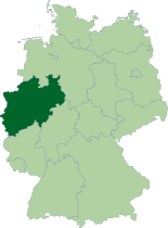
North Rhine-Westphalia (German: Nordrhein-Westfalen, usually shortened to NRW, official short form NW) is the westernmost and - in terms of population and economic output - the largest Federal State of Germany. North Rhine-Westphalia has over 18 million inhabitants, contributes about 22% of Germany's gross domestic product and comprises a land area of 34,083 km² (13,158 square miles). North Rhine-Westphalia is situated in the Western part of Germany and shares borders with Belgium and the Netherlands. It has borders with the German states of Lower Saxony to the North and Northeast, Rhineland-Palatinate to the Southwest and Hesse to the Southeast.
The capital city is Düsseldorf, and the largest city is Cologne (Köln). Other major cities are Dortmund, Essen, Duisburg, Oberhausen, Aachen, Bielefeld, Bonn, Bochum, Bottrop, Bergisch Gladbach, Mönchengladbach, Mülheim, Münster, Gelsenkirchen, Krefeld, Hagen, Hamm, Herne, Iserlohn, Leverkusen, Neuss, Paderborn, Recklinghausen, Remscheid, Siegen, Solingen, Witten and Wuppertal.
Contents |
Geography
The state is centred on the sprawling Rhine-Ruhr urbanised region, which contains the cities of Düsseldorf, Bonn and Cologne as well as the Ruhr Area industrial complex. The Ruhr area consists of, among others, the cities of Dortmund, Essen, Duisburg, Bochum, Gelsenkirchen and Oberhausen.
The state's area covers a maximum distance of 291 km from north to south, and 266 km from east to west.
The total length of the state's borders is 1,645 km. The following countries and states have a border with North Rhine-Westphalia:[2]
- Belgium (99 km)
- The Netherlands (387 km)
- Lower Saxony (583 km)
- Hesse (269 km)
- Rhineland Palatinate (307 km)
For many people North Rhine-Westphalia is synonymous with industrial areas and agglomerating cities. But the largest part of the state is used for agriculture (almost 52%), forests cover 25%.[3] The southern parts of the Teutoburg Forest are located in the northeast. In the southwest, Nordrhein-Westafalen shares in a small part of the Eifel, located on the borders with Belgium and Rheinland-Pfalz. The southeast is occupied by the sparsely populated regions of Sauerland and Siegerland. The northwestern areas of the state are part of the Northern European Lowlands.
The most important rivers that run at least partially through North Rhine-Westphalia include: Rhine, Ruhr, Ems, Lippe and Weser. The Pader, which runs only through the city of Paderborn, is considered the shortest river in Germany.
Subdivisions
See also List of places in North Rhine-Westphalia.
The state consists of five administrative regions (Regierungsbezirke), divided into 31 districts (Kreise) and 23 urban districts (kreisfreie Städte). In total, North Rhine-Westphalia has 396 municipalities (1997), including the urban districts, which are municipalities by themselves.

The districts of North Rhine-Westphalia:
|
|
||
|
|
|
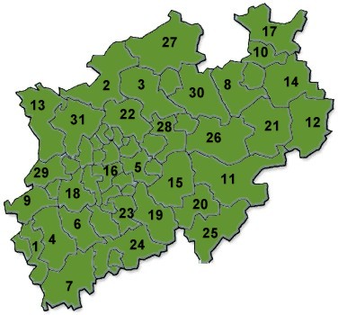
The urban districts:

The five administrative regions, belonging to one of two Landschaftsverbände:
- Rheinland (LVR)
- Köln
- Düsseldorf
- Westfalen-Lippe (LWL)
- Arnsberg
- Münster
- Detmold
History

The state of North Rhine-Westphalia was established by the British military administration on 25 October, 1946. Originally it consisted of Westphalia and the northern parts of the Rhine Province, both formerly belonging to Prussia. In 1947 the former state of Lippe was merged with North Rhine-Westphalia, hence leading to the present borders of the state.
The North Rhine-Westphalia state election on May 22, 2005 granted the CDU an unexpected victory. Their top candidate Jürgen Rüttgers built a new coalition government consisting of CDU and FDP that replaced the former government headed by Peer Steinbrück. Rüttgers was elected new Prime Minister (German: Ministerpräsident) of the federal state on June 22, 2005.
Flag
The flag of North Rhine-Westphalia is green-white-red with the combined coats of arms of the Prussian Rhine province (white line before green background, symbolizing the river Rhine), Westfalen (the white horse) and Lippe (the red rose).
According to legend the horse in the Westphalian coat of arms is the horse that the Saxon leader Widukind rode after his baptism. Other theories attribute the horse to Henry the Lion.
A regional anthem is the Lied für NRW (Song for NRW).
Politics
These are the Prime Ministers (German: Ministerpräsident) of the Federal State (German: Bundesland) of North-Rhine Westphalia (NRW):
- 1946 - 1947: Rudolf Amelunxen (Centre Party)
- 1947 - 1956: Karl Arnold (CDU)
- 1956 - 1958: Fritz Steinhoff (SPD)
- 1958 - 1966: Franz Meyers (CDU)
- 1966 - 1978: Heinz Kühn (SPD)
- 1978 - 1998: Johannes Rau (SPD)
- 1998 - 2002: Wolfgang Clement (SPD)
- 2002 - 2005: Peer Steinbrück (SPD)
- holding office: Jürgen Rüttgers (CDU)
The results of the North Rhine-Westphalia state election, 2005 were as follows. Note that overall seat totals have been reduced, lowering the seat counts for all parties.
Voter turnout was at 63%, an increase of 7% over the previous election in 2000. Prior to the election, some analysts had predicted that a CDU victory might result from disenchanted SPD voters staying home, but the turnout figures appear to reject this scenario.
| Party | Party List votes | Vote percentage (change) | Total Seats (change) | Seat percentage | ||
|---|---|---|---|---|---|---|
| Social Democratic Party (SPD) | 3,059,074 | 37.1% | -5.7% | 74 | -28 | 39.6% |
| Christian Democratic Union (CDU) | 3,695,806 | 44.8% | +7.9% | 89 | +1 | 47.6% |
| Free Democratic Party (FDP) | 508,354 | 6.2% | -3.7% | 12 | -12 | 6.4% |
| Alliance '90/The Greens | 509,219 | 6.2% | -0.9% | 12 | -5 | 6.4% |
| Electoral Alternative for Labor and Social Justice (WASG) | 181,886 | 2.2% | +2.2% | 0 | +0 | 0.0% |
| National Democratic Party (NPD) | 73,959 | 0.9% | +0.9% | 0 | +0 | 0.0% |
| Party of Democratic Socialism (PDS) | 72,982 | 0.9% | -0.2% | 0 | +0 | 0.0% |
| The Republicans | 67,282 | 0.8% | -0.3% | 0 | +0 | 0.0% |
| All Others | 74,810 | 0.9% | +0.5% | 0 | +0 | 0.0% |
| Totals | 8,243,372 | 100.0% | 187 | -44 | 100.0% | |

Notes and references
- ↑ "State population". Portal of the German Statistical Offices. Retrieved on 2007-04-25.
- ↑ Length of borders taken from Statistisches Jahrbuch NRW 2005, 47. Jahrgang, Landesamt für Datenverarbeitung und Statistik Nordrhein-Westfalen, p. 22
- ↑ Tatsachen über Deutschland (2003) Nordrhein-Westfalen, p. 44
External links
- Official Government Portal
- The Landtag of North Rhine-Westphalia
- Tourism
- Information and resources on the history of Westphalia on the Web portal "Westphalian History"
- Guidelines for the integration of the Land Lippe within the territory of the federal state North-Rhine-Westphalia of 17th January 1947
- North Rhine-Westphalia images from Cologne and Duesseldorf to Paderborn and Muenster
|
|||||||||||
|
||||||||||