North Brabant
| Provincie Noord-Brabant Province of North Brabant |
|||||
|
|||||
 |
|||||
| Capital | 's-Hertogenbosch | ||||
| Largest city | Eindhoven | ||||
| Queen's Commissioner | J.R.H. (Hanja) Maij-Weggen | ||||
| Religion (1999) | Protestant 7% Catholic 67% |
||||
| Area • Land • Water |
4,919 km² (2nd) 162 km² |
||||
| Population (2006) • Total • Density |
2,415,946 (3rd) 491/km² (5th) |
||||
| Inclusion | 1815 | ||||
| Anthem | none | ||||
| ISO | NL-NB | ||||
| Official website | www.brabant.nl | ||||
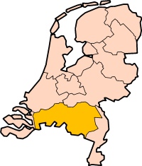
North Brabant (Dutch: Noord-Brabant, ) is a province of the Netherlands, located in the south of the country, bordered by Belgium in the south, the Meuse River (Maas) in the north, Limburg in the east and Zeeland in the west.
Contents |
History
Until the 17th century, the area that now makes up the province of North Brabant was mostly part of the Duchy of Brabant, of which the southern part is now in present-day Belgium. In the 14th and 15th century, the area experienced a golden age, especially the cities of Leuven (Louvain), Antwerp (both now in Belgium), Breda and 's-Hertogenbosch.
After the Union of Utrecht was signed in 1579, Brabant became a battlefield between the Protestant Dutch Republic and Catholic Spain, which occupied the southern Netherlands. As a result of the Peace of Westphalia, the northern part of Brabant became part of the Netherlands as the territory of Staats-Brabant (State Brabant) under federal rule, in contrast to the founding provinces of the Dutch Republic which were self-governing.
Attempts to preach Protestantism failed, and the area served mainly as a military buffer zone. In 1796, when the Netherlands became the Batavian Republic, Staats-Brabant became a province as Bataafs Brabant. This status ended with the reorganisation by the French, and the area was divided over several departments.
In 1815, Belgium and the Netherlands were united in the United Kingdom of the Netherlands, and the province of North Brabant was established, in order to distinguish it from South Brabant, in present-day Belgium, which separated from the Kingdom in 1830. This boundary between the Netherlands and Belgium is special in that it does not form a contiguous line, but there are a handful of tiny enclaves (and enclaves inside enclaves) on both sides of the border, such as Baarle-Hertog. When the province was founded, its territory was expanded with a part of the province of Holland and the former territory of Ravenstein which had previously belonged to the Duchy of Cleves, as well as several small, formerly autonomous entities.
From the end of the 19th century, the province has grown increasingly industrialised. Textile production was centred in Tilburg and Helmond, while the town of Eindhoven has grown to the country's 5th large city thanks to the Philips and Van Doorne's Automobiel Fabriek (DAF) companies.
Politics
The provincial council (Provinciale Staten) has 79 seats, and is headed by the Queen's Commissioner, currently Hanja Maij-Weggen. While the provincial council is elected by the inhabitants, the Commissioner is appointed by the Queen and the cabinet of the Netherlands. With 28 seats, the Christian-Democratic CDA is the largest party in the council.
The daily affairs of the province are taken care of by the Gedeputeerde Staten, which are also headed by the Commissioner; its members (gedeputeerden) can be compared with ministers.
Municipalities
North Brabant is currently divided into 68 municipalities. Traditionally, almost every town was a separate municipality, but their number was reduced greatly in the 1990s by incorporating smaller towns into neighbouring cities or by other mergers. The municipalities in North Brabant are:
|
|
Geography
Like most of the Netherlands, North Brabant is mostly flat but nearly every part of North Brabant is above sea level, therefore there are not as many canals as in the lower parts of The Netherlands. While most of the population lives in urban areas, the province is scattered with villages and most of the land is cultivated. Consistent with naturally raised areas, forests, heathlands and dune areas can also be found.
The province is bordered by the Meuse River in the north. Its delta flows through the Biesbosch area, a national park.
Economy
Employment is found in the agricultural, industrial and service sectors. The main agricultural products are wheat and sugar beet, while cows and pigs are held as livestock. The chief industries are automobile production, electronics (both mainly in Eindhoven), textile and shoes.
In the twentieth century, tourism has become an important sector for North Brabant, the woods and its quiet atmosphere combined with the beauty of some of the cities having proved successful. Another big tourist attraction is theme park Efteling in Kaatsheuvel, the largest of the Benelux.
See also
- Campine
External links
- Official Website (in Dutch)
- Province map showing subdivision in municipalities
- Merger Geldrop and Mierlo 1 Jan 2004, with map, http://www.geldrop-mierlo.nl/
- Deltaworks Online - Flood protection of North Brabant and Deltaregion
- Tourist information region Meierij & Northeast Brabant
|
|||||||