Nitra
- If you were looking for a chemical, see nitre or nitro.
| Nitra | ||
| City | ||
 |
||
|
||
| Country | ||
|---|---|---|
| Region | Nitra | |
| District | Nitra | |
| River | Nitra River | |
| Elevation | 190 m (623 ft) | |
| Coordinates | ||
| Highest point | ||
| - elevation | 587 m (1,926 ft) | |
| Lowest point | ||
| - elevation | 138 m (453 ft) | |
| Area | 100.48 km² (38.8 sq mi) | |
| Population | 84,800 (2006-12-31) | |
| Density | 844 /km² (2,186 /sq mi) | |
| First mentioned | 828 | |
| Mayor | Jozef Dvonč | |
| Timezone | CET (UTC+1) | |
| - summer (DST) | CEST (UTC+2) | |
| Postal code | 949 01 | |
| Area code | +421-37 | |
| Car plate | NR | |
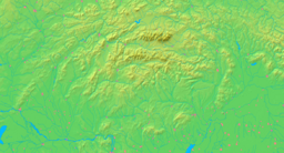  Location in Slovakia
|
||
  Location the Nitra Region
|
||
| Wikimedia Commons: Nitra | ||
| Statistics: MOŠ/MIS | ||
| Website: www.nitra.sk | ||

Nitra (pronunciation; German: Neutra (pronunciation); Hungarian: Nyitra / Nyitria [archaic]) is a city in western Slovakia, situated at the foot of Zobor Mountain in the Nitra River valley. With a population of 85,000, it is the fourth largest city in Slovakia[1]. Nitra is also one of the oldest cities in Slovakia and the country's earliest political and cultural center. Today, it is a seat of a kraj (Nitra Region) and an okres (Nitra District).
Contents |
Origin of the name
The first mention of Nitra dates back to 880 (other variations: 826 as Nitrawa, 880 as Nitra, and in 1111/1113 as Nitra, Nitria). The name of the city is derived from the nearby river, which name is originated from the germanic word Nitrahwa. In the indoeuropean languages Nid means flows while ahwa means water.
History
Inhabited for 6,000 years,[1] Nitra has been a city of extraordinary historic importance. A large Celtic settlement was founded in the 4th century BCE in the locality Martinský vrch. Nitra is later (396 CE) mentioned in connection to the Germanic tribe of Quadi, as their possible capital.
The first Slavs arrived in the 5th century. Nitra became the capital of the Principality of Nitra, the oldest known independent state in the present-day Slovakia. The first known Christian church built by the Western or Eastern Slavs was consecrated in 828 at the seat of the ruling prince Pribina, and in the same year the town was first mentioned as Nitrawa.[2] In 833, Pribina was ousted from Nitra by the Moravian prince Mojmír I and both principalities were united into the early medieval empire of Great Moravia. The Principality of Nitra was usually given to the heir of the Great Moravian throne as an appanage. But the practice eventually threatened unity of Great Moravia. Using rich resources of Nitra, both Prince Svätopluk I and Prince Svätopluk II revolted against their formal sovereigns. The level of autonomy they enjoyed was considerable, as documented by the Papal correspondence, addressing Svätopluk I of Nitra in the same way as two contemporaneous rulers of independent countries (Rastislav of Great Moravia, and Koceľ of the Balaton Principality).
The city reached its height during the reign of Svätopluk I, who was the prince of Nitra from the 850s to 871 and then the king of Great Moravia until 894. The first known Christian bishopric in Slovakia was established in Nitra in 880 (with Wiching as the bishop) and the first monastery in Slovakia was built on the Zobor Mountain during 880–881. During Svätopluk's rule, Nitra consisted of five large fortified settlements and twenty specialized craftsmen's villages, making it a real metropolis of its times. Several churches, for example in the Nitra Castle, Párovce, Nitrianska Blatnica, Lupka, Zobor, and Kostoľany pod Tribečom existed in and around today's Nitra during the 9th and 10th centuries. Located beyond the city limits are the Great Moravian settlements of Chrenová, Lupka, Branč, Vráble and Zlaté Moravce.
After the break-up of Great Moravia in 906/907, Nitra was conquered by a Magyar chieftain Lehel around 925. The Great Moravian appanage system was adopted by the Árpád dynasty of the newly established Kingdom of Hungary. As with much of the present-day Slovakia, Nitra was conquered by the Polish king Boleslaus I in 1001 and stayed as part of Poland until 1030. As the seat of heir of the dynasty, Nitra kept its autonomous status until 1108. Even after the abolishment of the principality, Nitra remained the capital of the Nitra county and a seat of a bishop (since 1110). The town survived the invasion of Mongols in 1241. In 1248, Béla IV gave Nitra the privileges of a free royal town. However, the privileges lasted only for 40 years and became a landlord's town. During the course of time, Nitra was controlled by Matthew Csák in the early 14th century, was affected by insurrections against Sigismund of Luxembourg and was a target of Hussite attacks in the 15th century.[3] After the Hungarian defeat at the Battle of Mohács in 1526 and subsequent Ottoman advances into the Hungarian territory, Nitra was under threat of Ottoman attacks. They failed to capture three times, before they conquered by it in 1663 and became center of the Litra sanjak, which bounded to Uyvar eyalet. The town was reconquered in 1685.[4] The town was also affected by anti-Habsburg uprisings, from Stephen Bocskay and Gabriel Bethlen uprisings in the 17th century to the Kuruc uprisings from 1703 to 1711, and the town burned out in 1708 as a result of fights.[5] It was renovated in the 18th century in the Baroque style. As a consequence of the Revolutions of 1848 and related events, Nitra got its own independent self-government for the first time since 1288 and wasn't dependent on the Diocese of Nitra and its bishops.[6] Until then an agricultural and handicraft town, Nitra also started to industrialize. Until World War I, distillery, agricultural machines factory, brewery, dairy and other works were established. The first indirect connection to a railway was a road built in 1850 to the closest station in Trnovec nad Váhom.[7] The railway finally arrived to Nitra in 1876, when a connection from Šurany was built. Later, lines were built to Topoľčany, Hlohovec and Nové Zámky. As a part of Magyarization, Nitra was from 1883 to 1919 seat of the Upper Hungarian Teaching Association (FEMKE), a government-sponsored association whose main goal was to apply Magyarization policies on Slovaks.
After World War I and disintegration of Austria-Hungary, the Czechoslovak Legions occupied the town on 10 December 1918 and became part of Czechoslovakia. Nitra continued to be the seat of the Nitra county, until it was dissolved in 1928. After break-up of Czechoslovakia, Nitra became a part of the First Slovak Republic and became again a seat of Nitra county until 1945, when it was conquered by the Soviet Red Army and Czechoslovakia was restored. The Communist period from 1948 to 1989 was marked by extensive growth, building of house estates and annexing of formerly independent villages. After the Velvet Revolution of 1989 and dissolution of Czechoslovakia, Nitra became part of newly established Slovakia and became a seat of the Nitra Region in 1996.
Geography
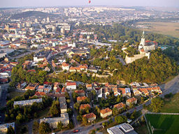
Nitra lies at an altitude of 190 metres (623 ft) above sea level and covers an area of 100.48 square kilometres (38.8 sq mi).[8] It is located in the Nitra River valley in the Danubian Lowland, where the bigger part of the city is located. A smaller part is located at the southernmost reaches of the Tribeč mountains, more precisely at the foothill of the Zobor mountain (587 m). It is around half-way between Slovak capital Bratislava, 92 kilometres (57 mi) away and central Slovak city of Banská Bystrica, 118 kilometres (73 mi) away. Other towns in the surroundings include Trnava to the west (53 km), Topoľčany to the north (35 km), Levice to the east (42 km), and Nové Zámky (37 km) and Komárno (71 km) to the south. A national natural reservation called Zoborská lesostep is located within the city's boundaries.
Climate
Nitra lies in the north temperate zone and has a continental climate with four distinct seasons. It is characterized by a significant variation between hot summers and cold, snowy winters. The city is located in the warmest and driest part of Slovakia.
| Month | Jan | Feb | Mar | Apr | May | Jun | Jul | Aug | Sep | Oct | Nov | Dec | |
|---|---|---|---|---|---|---|---|---|---|---|---|---|---|
| Average high °C (°F) | 2 (35) |
5 (41) |
10 (50) |
16 (62) |
22 (72) |
25 (77) |
27 (80) |
27 (81) |
21 (70) |
15 (60) |
8 (47) |
2 (36) |
|
| Average low °C (°F) | -4 (25) |
-3 (27) |
0 (33) |
5 (41) |
10 (49) |
13 (55) |
14 (58) |
14 (58) |
10 (51) |
6 (43) |
2 (36) |
-3 (27) |
|
| Precipitation cm (inches) | 2.78 (1.09) |
2.61 (1.03) |
2.84 (1.12) |
4.96 (1.95) |
4.80 (1.89) |
5.64 (2.22) |
6.87 (2.70) |
4.97 (1.96) |
6.51 (2.56) |
3.95 (1.56) |
4.70 (1.85) |
3.28 (1.29) |
|
| Source: MSN Weather[9] 2008-01-21 | |||||||||||||
Demographics

Nitra has a population of 85,172 (as of December 31, 2005). According to the 2001 census, 95.4% of inhabitants were Slovaks, 1.7% Hungarians, 0.9% Czechs, and 0.4% Roma. The religious make-up was 74.2% Roman Catholics, 17.2% people with no religious affiliation, and 2.8% Lutherans.[8]
The city really changed a lot in the last century, in 1910: Population of Nyitra in 1910 from the all (16 419) were 9754 Hungarians, 4929 Slovaks and 1636 Germans.
Economy
Nitra is the seat of the Nitra Region, which is an agricultural region. Food (brewery), mechanical and furniture industries are based in the city.[10] GDP per capita in 2001 was €3,643, which was below Slovakia's average (€4,400).[10]
The city plans to have in 2008 a balanced budget of 1.1 billion Slovak korunas (almost €34 million as of March 2008).[11]
Landmarks

Notable religious structures located in Nitra are the St. Emmeram Cathedral, a Piarist church, a Roman Catholic religious congregation founded by Saint Joseph Calasanctius and a monastery founded in the 13th-14th century. The monastery church was later destroyed by a fire and remodelled from 1742-1748 in baroque style. Two towers were also added onto the church. The main altar has a beautiful statue ornamentation which portrays Saint Stephen and Ladislaus I of Hungary. The interior was renovated in 1940 and three modern frescos depicting themes from Slovak history of Nitra were created. The oldest church of the city is the Saint Stephen church, which was built in the 11th-12th century, while the fundamentum of the building was constructed in the 9th century.
The old town (Staré Mesto) is dominated by a castle (Hrad), which is one of the most interesting ancient complexes of buildings in Slovakia. Archeological findings in the past decades indicate that a large fortified castle had already stood here at the time of Samo's Empire, in the seventh century. Recent archaeological findings prove the existence of a church from the ninth century beneath the younger, Gothic St. Emmeram Cathedral. The construction of the stone castle began during the 9th century during the reign of the Prince of Nitra Svätopluk. The castle currently serves as the seat of one of Roman-Catholic bishoprics in Slovakia, which was founded in 880 as the first bishopric of western and eastern Slavs, ceased to exist in the 10th century and was refounded around 1110.
The Dražovce church is a remarkable example of the early Romanesque architecture.
The most powerful medium wave transmitter of Slovakia, running on 1098 kHz, was situated in Nitra at Velke Kostolany until recently. This transmitter could broadcast throughout all of Europe at night. Since 2003, however, it has operated on lower output to save energy cost, and has transmitted regional programming only.
The Virgin Mary's mission house (Calvary) was built in 1765 for Spanish order of Nazarens. They had to take care of the church and nomands. Later, the building served as orphanage. In 1878-85 this building was rebuilt into Novoromanesque style and in 1925 one new floor was added to the building. The building as we know it today is a work of Slovak architect M. M. Harminec. Nowadays the whole building is mission house of The Divine Word Society. There is a mission museum in this building.
3D model of the building
Government

The city is governed by a mayor (Slovak: primátor) and a city council (Slovak: mestské zastupiteľstvo). The mayor is the head of the city and its chief executive. The term of office is for four years. The current mayor, Jozef Dvonč, won the municipal election in 2006 and is supported by these political parties: Smer-SD, KDH, SNS, SF and HZD. The city council is the legislative body, with 31 councillors.[10]
The city is divided into 13 urban districts (boroughs): Dolné Krškany, Horné Krškany, Staré Mesto, Čermáň, Klokočina, Diely, Párovské Háje, Kynek, Mlynárce, Zobor, Dražovce, Chrenová and Janíkovce.
Education

Nitra is the seat of two universities: University of Constantinus the Philosopher, with 13,684 students, including 446 doctoral students.[12] and of the Slovak University of Agriculture, with 10,297 students, including 430 doctoral students.[13]. The city's system of primary education consists of 14 public schools and three religious primary schools, enrolling in overall 6,945 pupils.[14] Secondary education is represented by five gymnasia with 3,349 students,[15], 8 specialized high schools with 3,641 students,[16] and 5 vocational schools with 3,054 students.[17][18]
Transport

Nitra is connected to Trnava and Bratislava by a fast expressway (E58). There are also first-class road connections to Topoľčany, Zlaté Moravce (labelled as "Highway of Death")[19], Vráble and Nové Zámky. A planned bypass in direction to Banská Bystrica is planned to be completed by 2010.[20] The railway track from Nové Zámky/Šurany to Prievidza crosses the city, but it isn't one of the main tracks. There is a junction bit north of the town, connecting it with Leopoldov, Topoľčany and Radošina. The closest international airport is the Bratislava Airport.
Local public transport is based on buses with 30 lines, covering the whole city, as well as extending to the neighbouring municipalities of Lužianky, Nitrianske Hrnčiarovce, Štitáre, Ivanka pri Nitre and Branč (as of March 2008).[21] There was a chairlift leading to Zobor hill, however, it has been closed since 1994.
Famous people

- Béla I of Hungary (1016-1063), Duke of Nitra, King of Hungary
- János Bottyán (1643-1709), Hungarian kuruc general
- Saint Bystrík (?-1046), Bishop of Nitra
- Tamás Esze (1666-1708) Hungarian kuruc leader died here in 1708
- Imre Erdősi (1814-1890), Hungarian piarist monk and teacher
- Vilmos Fraknói (1843-1924), Hungarian historian
- Béla Bangha (1880-1940), Hungarian politican was born here
- Oszkar Grosz (1896-1968), Shipowner in England
- Koceľ, Prince of the Balaton Principality
- Juraj Kolník (1980-), ice hockey player
- Anton Lehmden (1929-), painter, draughtsman, and printmaker
- Branislav Mezei (1980-), ice hockey player
- Ľubomír Moravčík (1965-), football player
- Zita Pleštinská, maiden name Kányaiová (1961-), member of the European Parliament
- Pribina (?-861), Prince of the Nitra and Balaton principalities
- Ottokár Prohászka (1858-1927), Hungarian Roman Catholic theologian and Bishop of Székesfehérvár
- Štefan Ružička (1985-), ice hockey player
- Miroslav Stoch (1989-), professional football (soccer player), currently signed with Chelsea F.C.
- Jozef Stümpel (1972-), ice hockey player
- Svatopluk I (830-894), Prince of Nitra, King of Great Moravia
- Svatopluk II (?-906), Prince of Nitra
- Boris Valabik(1986-), ice hockey player
Twin Towns - Sister Cities
Nitra is twinned with:
|
|
|
References
- ↑ History of Nitra from the municipal website
- ↑ Lacika, "Nitra and its environs", p. 21
- ↑ Lacika, "Nitra and its environs", pp. 31–32
- ↑ Lacika, "Nitra and its environs", pp. 33–35
- ↑ Lacika, "Nitra and its environs", pp. 34–36
- ↑ Lacika, "Nitra and its environs", p. 37
- ↑ Lacika, "Nitra and its environs", pp. 39–40
- ↑ 8.0 8.1 "Municipal Statistics". Statistical Office of the Slovak republic. Retrieved on 2007-05-03.
- ↑ "Monthly Averages for Nitra, Slovakia". MSN. Retrieved on 21 January, 2008.
- ↑ 10.0 10.1 10.2 "Urban Audit". Retrieved on 2007-12-14.
- ↑ "Rozpočet mesta Nitry na rok 2008 v programovej štruktúre" (doc) (in Slovak). Mestský úrad Nitra. Retrieved on 2008-03-23.
- ↑ "Univerzita Konštantína Filozofa" (PDF) (in Slovak). Ústav informácií a prognóz školstva. Retrieved on 2008-02-21.
- ↑ "Slovenská poľnohospodárska univerzita" (PDF) (in Slovak). Ústav informácií a prognóz školstva. Retrieved on 2008-02-21.
- ↑ "Prehľad základných škôl v školskom roku 2006/2007" (in Slovak). Ústav informácií a prognóz školstva (2006). Retrieved on 2008-02-21.
- ↑ "Prehľad gymnázií v školskom roku 2006/2007" (PDF) (in Slovak). Ústav informácií a prognóz školstva. Retrieved on 2008-02-21.
- ↑ "Prehľad stredných odborných škôl v školskom roku 2006/2007" (PDF) (in Slovak). Ústav informácií a prognóz školstva. Retrieved on 2008-02-21.
- ↑ "Prehľad združených stredných škôl v školskom roku 2006/2007" (PDF) (in Slovak). Ústav informácií a prognóz školstva. Retrieved on 2008-02-21.
- ↑ "Prehľad stredných odborných učilíšť a učilíšť v školskom roku 2006/2007" (PDF) (in Slovak). Ústav informácií a prognóz školstva. Retrieved on 2008-02-21.
- ↑ "Nitra: Under the giant’s shoulders". Spectacular Slovakia (2007). Retrieved on 2008-03-24.
- ↑ Ján Gana (2008). "Rýchlostné cesty (Expressways)" (in Slovak). highways.sk. Retrieved on 2008-03-24.
- ↑ "Public transport in Nitra". imhd.sk (2008). Retrieved on 2008-03-24.
- ↑ "Zielona Góra - Partner Cities". © 2008 Urzędu Miasta Zielona Góra.. Retrieved on 2008-12-07.
Literature
- Lacika, Ján (2003). Nitra and its environs. Visiting Slovakia (1st ed. ed.). Bratislava, Slovakia: Dajama. ISBN 80-88975-53-0.
External links
- Nitra.sk – Official Website
- Panoramic photo gallery of Nitra
- Historical photos of Nitra
- Development news, photos, shopping centers
|
|||||||
|
|||||||