Napa, California
| Napa, California | |
 |
|
| Coordinates: | |
| Country | United States |
|---|---|
| State | California |
| County | Napa |
| Government | |
| - Mayor | Jill Techel |
| Area | |
| - Total | 17.8 sq mi (46 km²) |
| - Land | 17.7 sq mi (45.8 km²) |
| - Water | 0.1 sq mi (0.2 km²) |
| Elevation | 20 ft (6 m) |
| Population (2000) | |
| - Total | 72,585 |
| - Density | 4,077.8/sq mi (1,577.9/km²) |
| Time zone | Pacific (PST) (UTC-8) |
| - Summer (DST) | PDT (UTC-7) |
| ZIP codes | 94558, 94559, 94581 |
| Area code(s) | 707 |
| FIPS code | 06-50258 |
| GNIS feature ID | 0277561 |
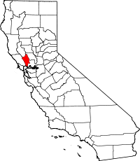
Napa is the county seat of Napa County, California. It is the principal city of the Napa county Metropolitan Statistical Area, which encompasses Napa county. As of the 2000 census, the city had a total population of 72,585. The area was settled in the 1830s. It was incorporated as a city in 1872.
On December 31, 2005, the Napa River overflowed and flooded the entire downtown area and thousands of acres all over Napa County. More than 4,000 residents were evacuated and 1,000 homes were flooded or destroyed.[1] The flood of 12/31/05 was the 23rd most serious flood on the Napa River on record since 1865.
Contents |
Geography and environment
Napa is located at (38.304764, -122.298885)[2].
According to the United States Census Bureau, the city has a total area of 32.2 km² (17.8 mi²). 45.8 km² (17.7 mi²) of it is land and 0.2 km² (0.1 mi²) of it (0.51%) is water. The Napa River traverses the city on its journey to the San Pablo Bay. The city has conducted a variety of waterfront development along the Napa River including certain fill operations governed by the United States Army Corps of Engineers regulations.[3] The Napa River Flood Project has been in progress since the late 1990s with the goal of mitigating the risk of flooding along a 6-mile (9.7 km) stretch of the River and 1-mile (1.6 km) of Napa Creek.
Climate
Napa has cool, wet winters and very warm, dry summers. In January, average temperatures range from 57.5 °F (14.2 °C) to 37.9 °F (3.3 °C). In July, average temperatures from range from 82.1 °F (27.8 °C) to 53.0 °F (11.7 °C). There are an average of 25.3 days with highs of 90 °F (32 °C) or higher and an average of 23.4 days with lows of 32 °F (0 °C) or lower. The record high temperature was 113 °F (45 °C) on June 14, 1961. The record low temperature was 14 °F (−10 °C) on December 22, 1990.
Average annual precipitation in Napa is 24.84 inches (631 mm) and there are an average of 64 days annually with measurable precipitation. The wettest year was 1983 with 51.29 inches (1,303 mm) and the dryest year was 1939 with 10.37 inches (263 mm). The most rainfall in one month was 16.13 inches (410 mm) in December 1955, when major flooding occurred in the area. The most rainfall in 24 hours was 5.85 inches (149 mm) on November 21, 1977. Although snow is rare, 1.0 inch fell on March 22, 1987.[4]
History
The name Napa was probably derived from the name given to a southern Nappan village whose people shared the area with elk, deer, grizzlies and panthers for many centuries. At the time of the first recorded exploration into Napa Valley in 1823, the majority of the inhabitants consisted of Native American Indians. Padre Jose Altimira, founder of Mission San Francisco Solano in Sonoma, led the expedition. Spanish and then later Mexican control remained until the Bear Flag Revolt, and American farmers began arriving in the 1830s.
When California was granted statehood in 1849, Napa Valley was in the Territory of California, District of Sonoma. In 1850 when counties were first organized, Napa became one of the original counties of California. In 1851, the first courthouse was erected. By 1870, the Native American demographics changed significantly, probably due to the cause of U.S. Manifest Destiny by Americans. Even though Spanish settlers were the first Europeans to settle the area, they did not interfere with the vast majority of Native Americans despite controlling the region. Today, Native Americans native to the area, live in and around Alexander Valley, where they also live on reservations granted by the government.
The City of Napa was founded by Nathan Coombs in 1847. The townsite was surveyed by James M. Hudspeth on property Coombs had received from Nicolas Higuerra, holder of the original Spanish Grant. The first business establishment in the town was a saloon built by Harrison Pierce a former miller at the Bale Grist Mill. Napa's first general store was opened a year later in 1848 by Joseph P. Thompson. By 1850 the Dophin became the first steamship to navigate the Napa River in order to open another path of commerce.
Nathan Coombs and many other important City founders and builders are buried nearby in Tulocay Cemetery. Near the entrance is the tomb of Mary (Mammy) Pleasant who is considered the Mother of Civil Rights in California.
In the mid 1850s, Napa Main Street rivaled that of many larger cities, with as many as 100 saddle horses tied to the fences on an average afternoon. Hotels were crowded, cash slugs and California coinage were plentiful. Saloons and gambling emporiums were numerous. The Lyceum movement established a facility and reading room and an agricultural society was started. Two newspapers began publication in the 1850s. The Napa Valley Register made its debut in 1853 and Alexander J. Cox published the Napa County Reporter for the first time on July 4, 1856. The Napa Opera House became popular but, it languished. It was closed for many years until a popular movement re-established and rebuilt the building. Today, it currently hosts many popular entertainers.
The California Gold Rush of the late 1850s expanded Napa City. After the first severe winter in the gold fields, miners sought refuge in the young city from snow, cold, floods and disease. A tent city was erected along Main Street. There was plenty of work in the valley for disillusioned miners. Many cattle ranches were maintained, and the lumber industry had mushroomed. Sawmills in the valley were in operation cutting up timber that was hauled by team to Napa City, then shipped out on the river to Benicia and San Francisco.
In 1858 the great silver rush began in Napa Valley, and miners eagerly flocked to the eastern hills. In the 1860s, mining carried on, in a large scale, with quicksilver mines operating in many areas of Napa County. The most noted mine was the Silverado Mine, near the summit of Mt. St. Helena. The mine was immortalized by Robert Louis Stevenson in his classic The Silverado Squatters.
In 1869 F.A. Sawyer established Sawyer Tanning Company in Napa and was joined in the business by his father B.F. Sawyer a year later. It went on to become the largest tannery west of the Mississippi River.
Napa was incorporated in 1872 and reincorporated again in 1874 as the City of Napa.
The Napa State Asylum for the Insane located just south of Napa received its first patients in 1876. The Napa Valley Opera House made its debut on February 13, 1880 with a production of Gilbert and Sullivan’s HMS Pinafore.
Napa had become the primary business and economic center for the Napa Valley by the dawn of the 20th century. As agricultural and wine interests developed north of the city limits much of the light industry, banking, commercial and retail activity in the county evolved within the city of Napa and in earlier times along the Napa River through the historic downtown. Napa Glove Factory was established in 1903 and was the largest plant of its kind west of Chicago. In 1915 Edwin Pridham and Peter L. Jensen invented the moving-coil loudspeaker in their Napa workshop while working on an improvement for the telephone receiver. Pridham and Jensen went on to found the Magnavox Company in 1917
Even today the bulk of the county population lives in the City of Napa. The active economic development program has continued to support the wine and agricultural activities of the Valley to this day.
Demographics
As of the census[5] of 2006, there were 74,966 people, 20,001 households, and 12,453 families residing in the city. The population density was 1,234.5/km² (4,101.4/mi²). There were 27,776 housing units at an average density of 605.9/km² (1,569.5/mi²). The racial makeup of the city was 90.11% White, 0.21% African American, 7.32% Native American, 2.71% Asian, 1.08% Pacific Islander, 0.65% from other races, and 0.35% from two or more races. Hispanic or Latino of any race were 26.83% of the population.
There were 26,978 households out of which 32.9% had children under the age of 18 living with them, 50.7% were married couples living together, 11.1% had a female householder with no husband present, and 33.5% were non-families. 26.8% of all households were made up of individuals and 12.1% had someone living alone who was 65 years of age or older. The average household size was 2.64 and the average family size was 3.20.
In the city the population was spread out with 25.7% under the age of 18, 8.5% from 18 to 24, 29.6% from 25 to 44, 22.4% from 45 to 64, and 13.8% who were 65 years of age or older. The median age was 36 years. For every 100 females there were 96.4 males. For every 100 females age 18 and over, there were 93.5 males.
The median income for a household in the city was $49,154, and the median income for a family was $58,788. Males had a median income of $41,046 versus $31,334 for females. The per capita income for the city was $23,642. About 6.1% of families and 8.9% of the population were below the poverty line, including 11.4% of those under age 18 and 5.5% of those age 65 or over.
Politics
In the state legislature Napa is located in the 2nd Senate District, represented by Democrat Pat Wiggins, and in the 7th Assembly District, represented by Democrat Noreen Evans. Federally, Napa is located in California's 1st congressional district.
Transport
Napa is served by Oakland International Airport, 40 miles away in Oakland,in the San Francisco Bay Area.
Sister cities
 Iwanuma, Japan (1973)
 Telavi, Georgia (country) (1987)
 Launceston, Tasmania, Australia (1988)
See also
Famous residents
- Jerry Bohlander, professional MMA (mixed martial arts) fighter
- Phil Bonifield, NASCAR driver
- Warren Brusstar, former MLB player
- Michael Chiarello, celebrity chef
- Cristina García, novelist
- Jim Landis, former MLB player
- Bret Lyman, filmmaker
- Ray Manzarek, The Doors keyboard player
- Peter Menzel, photographer
- Robert Redford (part time), actor
- Donny Robinson, 2008 Summer Olympics BMX bronze medalist
- Sly Stone, musician
- Robin Williams, actor
References
- ↑ Kevin Courtney (2005). "Severe flooding hits the Napa Valley". Napa Valley Register. Retrieved on 2005-12-31.
- ↑ "US Gazetteer files: 2000 and 1990". United States Census Bureau (2005-05-03). Retrieved on 2008-01-31.
- ↑ Section 404 (b) 1 Alternatives Analysis Pursuant to 40 CFR 230.10 for the Safeway Longs Center, Napa, Ca., Earth Metrics Inc., U.S. Army Corps of Engineers Document, August, 1989
- ↑ Western Regional Climate Center website
- ↑ "American FactFinder". United States Census Bureau. Retrieved on 2008-01-31.
External links
- City of Napa Official Website
- Napa County Chronology, based on information from the book From Golden Fields to Purple Harvest
- Napa, California is at coordinates
- Napa Valley Register website
- KVON-AM
- KVYN-FM
- Napa Relocation Info, weather, news, schools, doctors, and local resources
- Official site of Napa artist Sally Rosenbaum
- Napa County Historical Society
|
|||||||||||||||||
|
|||||||||||
|
|||||||||||||||||||||||||
|


