Thurgau
| Thurgau | |||
|
|||
| Capital | Frauenfeld | ||
| Population (2007) | 238,316 (Ranked 13th) | ||
| - Density | 238 /km² | ||
| Area | 991 km² (Ranked 12th) | ||
| Highest point | 991 m - Hohgrat | ||
| Lowest point | 370 m - Thur River at the cantonal border in Neunforn | ||
| Joined | 1803 | ||
| Abbreviation | TG | ||
| Languages | German | ||
| Executive | Regierungsrat (5) | ||
| Legislative | Grosser Rat (130) | ||
| Municipalities | 80 municipalities | ||
| Districts | 8 Bezirke | ||
| Website | www.TG.ch | ||
 |
|||

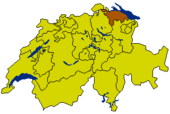
Thurgau (German: Thurgau, anglicized as Thurgovia) is a northeast canton of Switzerland. The population is 238,316 (2007) of which 47,390 (or 19.9%) are foreigners[1]. The capital is Frauenfeld.
Contents |
Geography
To the north the canton is bound by the Lake Constance across which lies Germany and Austria. The river Rhine creates the border in the northwest. To the south lies the canton of St. Gallen; to the west lie the cantons of Zürich and Schaffhausen.
The area of the canton is 991 km² and commonly divided into three hill masses. One of these stretches along Lake Constance in the north. Another is further inland between the river Thur and the river Murg. The third one forms the southern border of the canton and merges with the Hörnli mountain in the pre-Alps.
History
In prehistoric times the lands of the canton were inhabited by people of the Pfyn culture along the lake. During Roman times the canton was part of the province Raetia until in 450 the lands were settled by the Alamanni. It was only in the 8th century that the canton became a political unit similar to what it is known today, as a Gau of the Frankish Empire. At the time, however, the area was not so clearly defined and changed frequently. Overall, the size of the Thurgau was larger, but during the Middle Ages the canton became smaller in size. The dukes of Zähringen and the counts of Kyburg took over much of the land. The town of Zürich was part of the Thurgau until it became reichsunmittelbar in 1218. When the Kyburg dynasty became extinct in 1264 the Habsburgs took over that land. The Swiss confederation allied with ten freed bailiwicks of the former Toggenburg seized the lands of the Thurgau from the Habsburgs in 1460, and it became a subject territory of seven Swiss cantons (Zurich, Lucerne, Uri, Schwyz, Unterwalden, Zug and Glarus).
During the Protestant Reformation in Switzerland, both the Catholic and emerging Reformed parties sought to swing the subject territories, such as the Thurgau, to their side. In 1524, in an incident that resonated across Switzerland, local peasants occupied the cloister of Ittingen in the Thurgau, driving out the monks, destroying documents, and devastating the wine-cellar. Between 1526 and 1531, most of the Thurgau's population adopted the new Reformed faith spreading from Zurich; Zurich's defeat in the War of Kappel (1531) ended Reformed predominance. Instead, the First Peace of Kappel protected both Catholic and Reformed worship, though the provisions of the treaty generally favored the Catholics, who also made up a majority among the seven ruling cantons. Religious tensions over the Thurgau were an important background to the First War of Villmergen (1656), during which Zurich briefly occupied the Thurgau.
In 1798 the land became a canton for the first time as part of the Helvetic Republic. In 1803, as part of the Act of Mediation, the canton of Thurgau became a member of the Swiss confederation. The current cantonal constitution dates from 1987.

Economy
The canton of Thurgau is known for its fine agricultural produce. Particularly, apples, pears, fruits and vegetables are well-known. The many orchards in the canton are mainly used for the production of cider. Wine is produced in the Thur valley.
There is also industry in the canton of Thurgau. The main industries are printing, textiles and handicrafts. Small and middle-sized businesses are important for the cantonal economy. Many of these are concentrated around the capital.
Demographics
The population is mostly German speaking. About two thirds of the population are Protestants with most of the remainder being Roman Catholics.
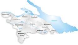
Districts

The Canton of Thurgau is divided into eight districts, and each is named after its capital:
- Steckborn with capital Steckborn
- Frauenfeld with capital Frauenfeld
- Kreuzlingen with capital Kreuzlingen
- Weinfelden with capital Weinfelden
- Bischofszell with capital Bischofszell
- Diessenhofen with capital Diessenhofen
- Münchwilen with capital Münchwilen
- Arbon with capital Arbon
Municipalities
There are 80 municipalities in the canton (as of April 2004[update]):
|
|
|
See also: municipalities of Switzerland
External links
- Official website (German)
- Official statistics
References
- ↑ Bundesamt fur Statistik (Federal Department of Statistics) (2008). "Ständige Wohnbevölkerung nach Staatsangehörigkeit, Geschlecht und Kantonen" (Microsoft Excel). Retrieved on 5 November 2008.
|
|||||