Mount Washington (New Hampshire)
| Mount Washington | |
|---|---|
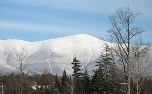 Mount Washington, from Bretton Woods. The cog railway track is visible, on the spur to the left of the summit. |
|
 Mount Washington
|
|
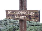
| Elevation | 6,288 feet (1,917 m) |
| Location | Sargent's Purchase, Coos County, New Hampshire, USA |
| Range | Presidential Range |
| Prominence | 6,138 ft (1,871 m) [1] |
| Coordinates | [2] |
| Topo map | USGS Mount Washington [2] |
| First ascent | 1642 |
| Easiest route | Hike from Marshfield Station, take the Cog to the summit, or drive from NH Route 16 in Pinkham Notch during the summer. |
| Listing | Ultra prominent peak; White Mountain 4000-footers; #1 New England Fifty Finest; U.S. state high point |
Mount Washington is the highest peak in the Northeastern United States at 6,288 ft (1,917 m). It is famous for its dangerously erratic weather, holding the record for the highest wind gust directly measured at the Earth's surface, at 231 mph (372 km/h) on the afternoon of April 12, 1934. It was known as Agiocochook, or "home of the Great Spirit", before European settlers arrived.[3]
The mountain is located in the Presidential Range of the White Mountains, in Coos County, New Hampshire. It is the third highest state high point in the eastern U.S., after Mount Mitchell, North Carolina – 6,684 ft (2,037 m) – and Clingmans Dome, Tennessee – 6,643 ft (2,025 m) – and is the most prominent peak in the Eastern United States.
While nearly the whole mountain is in the White Mountain National Forest, an area of 59 acres (0.24 km2) surrounding and including the summit is occupied by Mount Washington State Park.
Contents |
History

Darby Field claimed to have made the first ascent of Mt. Washington in 1642.[4] The oldest mountain hiking trail in America, the Crawford path was laid out in 1819 as a bridle path and has been in use ever since. Little activity occurred on the summit itself until the middle of the 19th century when it was developed as one of the first intentional tourist destinations in the country, with the construction of more bridle paths and several summit hotels including the Tip Top House, which is still standing and was recently renovated as a historical exhibit. Other tourist construction in the 19th century included a stagecoach road — now the Mount Washington Auto Road — and the Mount Washington Cog Railway (1869), both of which are still used.
Weather

Mount Washington has notoriously erratic weather. This is partly due to the convergence of several storm tracks, mainly from the South Atlantic, Gulf region and Pacific Northwest. The vertical rise of the Presidential Range, combined with its north-south orientation, makes it a significant barrier to westerly winds. Low-pressure systems are more favorable to develop along the coastline in the winter months due to the relative temperature differences between the Northeast and the Atlantic Ocean. With these factors combined, winds exceeding hurricane force occur an average of 110 days per year. From November to April, these strong winds are likely to occur during two-thirds of the days.
Mount Washington holds the world record for directly measured surface wind speed, at 231 mph (372 km/h), recorded on the afternoon of April 12, 1934. Phenomena measured via satellite or radar, such as tornadoes, hurricanes, and air currents in the upper atmosphere, are not directly measured at the Earth's surface and do not compete with this record, although a tornado might qualify if measured directly and accurately. (The highest wind speed ever measured in a tornado is approximately 301 mph (480 km/h) in the F5 Moore, Oklahoma tornado, though the reading was taken about 100 ft (30 m) above the ground.[5])
The first regular meteorological observations on Mount Washington were conducted by the U.S. Signal Service, a precursor of the National Weather Service, from 1870 to 1892. The Mount Washington station was the first of its kind in the world, setting an example followed in many other countries. For many years, the record low temperature was thought to be −47 °F (−43.9 °C) occurring on January 29, 1934, but upon the first in-depth examination of the data from the 1800s at NOAA's National Climatic Data Center in Asheville, North Carolina, a new record low was discovered. Mount Washington's official record low of −50 °F (−45.6 °C) was recorded on January 22, 1885. However, there is also hand-written evidence to suggest that an unofficial low of −59 °F (−50.6 °C) occurred on January 5, 1871.
On January 16, 2004, the summit weather observation registered a temperature of −43.6 °F (−42.0 °C) and sustained winds of 87.5 mph (140.8 km/h), resulting in a wind chill value of −103 °F (−75.0 °C) at the mountain.[6] During a 71-hour stretch from around 3 p.m. on January 13 to around 2 p.m. on January 16, 2004, the wind chill on the summit never went above −50 °F (−46 °C).[6] Snowstorms at the summit are routine in every month of the year, with snowfall averaging 645 cm (21.2 ft) per year.
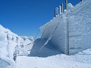
The primary summit building was designed to withstand 300 mph (480 km/h) winds; other structures are literally chained to the mountain. In addition to a number of broadcast towers, the mountain is the site of a non-profit scientific observatory reporting the weather as well as other aspects of the subarctic climate of the mountain. The extreme environment at the top of Mount Washington makes using unmanned equipment problematic. The observatory also conducts research, primarily the testing of new weather measurement devices. The Sherman Adams summit building, which houses the Observatory, is closed to the public during the winter and hikers are not allowed inside the building except for emergencies and pre-arranged guided tours.
The Mount Washington Observatory reoccupied the summit in 1932 through the enthusiasm of a group of individuals who recognized the value of a scientific facility at that demanding location. The Observatory's weather data have accumulated into a valuable climate record since. Temperature and humidity readings have been collected using a sling psychrometer, a simple device containing two mercury thermometers. Where most unstaffed weather stations have undergone technology upgrades, consistent use of the sling psychrometer has helped provide scientific precision to the Mount Washington climate record.
The Observatory makes prominent use of the slogan "Home of the World's Worst Weather", a rather doubtful claim which originated with a 1940 article by Charles Brooks (the man generally given the majority of credit for creating the Mount Washington Observatory), titled "The Worst Weather In the World" (even though the article concluded that Mt Washington most likely did not have the world's worst weather).[7][8]
Geographical features
Although the western slope that the Cog Railway ascends is straightforward from base to summit, the mountain's other sides are more complex. On the north side, Great Gulf — the mountain's largest glacial cirque — forms an amphitheater surrounded by the Northern Presidentials: Mounts Clay, Jefferson, Adams and Madison. These connected peaks reach well into the treeless alpine zone. Massive Chandler Ridge extends northeast from the summit of Washington to form the amphitheater's southern wall and is the incline ascended by the automobile road.
East of the summit, a plateau known as the Alpine Gardens extends south from Chandler Ridge at about 5,200 feet (1,600 m) elevation. It is notable for plant species either endemic to alpine meadows in the White Mountains or outliers of larger populations in arctic regions far to the north. Alpine Gardens drops off precipitously into two prominent glacial cirques. Craggy Huntington Ravine offers rock and ice climbing in an alpine setting. More rounded Tuckerman Ravine is New England's premiere venue for spring skiing as late as June and then a scenic hiking route.
South of the summit lies a second and larger alpine plateau, Bigelow Lawn, at 5,000 feet (1,500 m) to 5,500 feet (1,700 m) elevation. Satellite summit Boott Spur and then the Montalban Ridge including Mount Isolation and Mount Davis extend south from it, while the higher Southern Presidentials — Mounts Monroe, Franklin, Eisenhower, Pierce, Jackson and Webster — extend southwest to Crawford Notch. Oakes Gulf separates the two high ridges.
Uses
The mountain is part of a popular hiking area, with the Appalachian Trail crossing the summit and one of the Appalachian Mountain Club's eight mountain huts, the Lakes of the Clouds Hut, located on one of the mountain's shoulders. Winter recreation includes Tuckerman Ravine, famous for its Memorial Day skiing and its 45-degree slopes. The ravine is notorious for its avalanches, of which about 100 are recorded every year, and which have killed six people since 1849.[9] Scores of hikers have died on the mountain in all seasons, due to inadequate equipment, failing to plan for the wide variety of conditions which can occur above tree line, and poor decisions once the weather began to turn dangerous.[10]
The weather at Mount Washington has made it a popular site for glider flying. In 2005, it was recognized as the 14th National Landmark of Soaring.[11]
Hiking

The most popular mountain hiking trail approach to the summit is via the Tuckerman Ravine Trail, which starts from the Pinkham Notch camp area and is 4.2 miles (6.8 km) long, with an elevation gain of 4,280 feet (1,300 m). It leads the hiker straight up the bowl of Tuckerman Ravine via a series of steep granite steps and affords spectacular views of the ravine itself and across the notch to Wildcat Mountain. Anyone who can walk comfortably for about ten miles should be able to hike this on a pleasant summer's day, but they should carry winter clothing for the last half mile to the summit (see the section on the weather, above). Over the years there have been fatalities on the trail, mostly from ski accidents, but many from hypothermia. Water bottles can be refilled at a well pump near the halfway house, which is 2.1 miles (3.4 km) along the trail at the bottom of the bowl. Here there is a small hiker's store for snacks, toilets and shelter. At the summit, there is a center with a museum, gift shop, observation area, and cafeteria, where the chili has warmed cold and hungry hikers for decades. For hikers with bad knees, the descent can be made by shuttle bus back to the Pinkham Notch camp for twenty-six dollars.
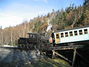
Cog Railway

Since 1869, the Mount Washington Cog Railway has pulled tourists up to the summit of Mount Washington using a Marsh rack system, the first successful rack railway in the US. This historical ride is quite popular with train buffs, and the whistle of the engine has reassured many hikers in the cloudy mist that they are nearing the summit.
A tradition of thru-hikers Mooning the Cog has developed on Mount Washington as the trail and railroad intersect near the summit of the mountain.[12][13]
Races
Every year in June, the mountain is host to the Mount Washington Road Race, an event which attracts hundreds of runners. In July the mountain is the site of Newton's Revenge and in August the Mount Washington Auto Road Bicycle Hillclimb, both of which are bicycle races that run the same route as the road race. The hillclimb's most notable victor to date has been former Tour de France contender Tyler Hamilton.
Another event, although not a race, is the annual MINIs On Top event. The drive to the summit began with 73 MINI Cooper and Cooper S vehicles and now exceeds 200 cars. MINIs On Top (or MOT) is held the Saturday of Father's Day weekend every June. The Mt. Washington Auto Road has also hosted the Mt. Washington Alternative Energy Days, a two-day gathering of alternative energy alternative vehicles.
On August 7, 1932, Raymond E. Welch, Sr., became the first one-legged man to climb Mount Washington. An official race was held and open only to one-legged people. Mr. Welch climbed the "Jacob's Ladder" route and descended via the carriage road. Raymond Welch had lost his leg due to a sledding injury as a seven year old child. This climb was recognized by the Boston Globe, Manchester Union, and Plymouth Record newspapers. At the time of his climb, Mr. Welch was the station agent for the Boston & Maine Railroad in Northumberland, New Hampshire.
Transmitting stations
Edwin H. Armstrong installed an FM-broadcasting station on the top of Mount Washington in 1937. The station stopped operating in 1948, due to excessive maintenance costs. In 1954 a TV tower and transmitters were installed for WMTW, Channel 8, licensed to Poland Spring, Maine. The station continuously broadcast from the top of the mountain, including local forecasts by (now retired) WMTW transmitter engineer Marty Engstrom.[14] WMTW continually broadcast from the mountaintop until 2002.
Mount Washington continued FM broadcasting in 1958 with the construction of WHOM 94.9, which was then WWMT. WHOM and WMTW-TV both shared a transmitter building, which also housed the generators to supply power to the mountain. On February 9, 2003, a fire[15] destroyed the transmitter building and the generators (where it started), which at the time still had WHOM's transmitters inside it. WHOM subsequently built a new transmitter building on the site of the old power building, and also constructed a new standby antenna on the Armstrong tower. (For the first time since 1948, the Armstrong tower was used for broadcasts.)
In 1987, WHOM and WMTW where joined on the peak of the mountain by WMOU-FM (now WPKQ) on a separate tower. The WPKQ transmitters are located in the back of the Yankee Building. Due to the extreme weather on Mount Washington, both WHOM and WPKQ use specially designed FM antennas which are housed in special cylindrical radomes, manufactured by Shively Labs of nearby Bridgton, Maine.
In June 2008, the possibility of television returning to Mount Washington came to the light, with the filing by New Hampshire Public Television to move WLED-TV from its current location near Littleton to the old WMTW mast on top.[16][17]
Artistic tributes

Mount Washington from the Valley of Conway
Mount Washington has been the subject of several famous New England paintings, dating from the French and Indian wars. During the late 1700s and early 1800s an artist colony in Conway generated a flood of landscape paintings that have found their way across the world, most notably in Hampton Court. Musical tributes have also been made, such as Symphony no. 64, Op. 422 ("Agiochook"), composed around 1990 by the American composer Alan Hovhaness (1911–2000), which is dedicated to Mount Washington, and which the composer climbed during his youth.
See also
- List of U.S. states by elevation
- Mountain peaks of North America
- Mountain peaks of the United States
- Pinkham Notch
Notes

- ↑ "America's 57 - The Ultras". Peaklist - Prominence of Mountains of the World. Retrieved on 2008-08-30.
- ↑ 2.0 2.1 "Mount Washington". Geographic Names Information System. U.S. Geological Survey (27-AUG-1980). Retrieved on 2008-11-28.
- ↑ "Dartmouth College Library Collections". Proquest.com. Retrieved on 2008-03-08.
- ↑ USGW Archives C. Norris & Co. , Exeter, NH, ©1817 (1817). "Gazetteer of the State of New Hampshire 1817". Retrieved on 2008-08-24.
- ↑ Center for Severe Weather Research (2006). "Doppler on Wheels". Retrieved on 2006-12-29.
- ↑ 6.0 6.1 "History for Mt. Washington, NH". Weather Underground. Retrieved on 2008-03-08.
- ↑ Allen Press "The Mount Washington Weather Observatory - 50 Years Old"
- ↑ "The Worst Weather In the World"
- ↑ MountWashington.com - Deaths
- ↑ ibid.
- ↑ "Mount Washington National Landmark of Soaring". Mount Washington Soaring Association, chapter of Soaring Society of America. Retrieved on 2008-10-08.
- ↑ Patricia Pelosi (2007-11-15). "Officials Charge Hikers Who Moon Cog Railway". WLBZ, Bangor. Retrieved on 2008-03-08.
- ↑ Katie Zezima (2007-11-23). ""Riding the Rail to the Top, and Not Amused"". The New York Times. Retrieved on 2008-03-08.
- ↑ Marty Engstrom. Marty on the Mountain: 38 Years on Mt. Washington. http://www.mountwashington.org/store/index.php?main_page=product_info&products_id=36. Retrieved on 2008-10-13.
- ↑ "WMTW: fire on the mountain". GGN Information Systems. Retrieved on 2008-10-13.
- ↑ "Application for Construction Permit for Reserved Channel Noncommercial Educational Broadcast Station". U.S. Federal Communications Commission (FCC) (June 20, 2008). Retrieved on 2008-10-13.
- ↑ ""Mount Washington, N.H.: A Look Back"". fybush.com (2003-02-20). Retrieved on 2008-03-08.
External links
- Mount Washington Observatory
- Mount Washington Cog Railway
- Mount Washington Auto Road
- 19th Century Paintings of Mount Washington
- Mount Washington weather facts
- Computer generated summit panoramas North South West to Adirondack Group Index
- PeakBagger.com entry
|
|||||
|
|||||||||||||||||||||||||||||||||||||||||||||||||||||