Mount Rainier
| Mount Rainier | |
|---|---|
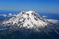
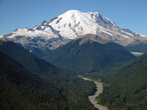 Mount Rainier as viewed from the northeast. |
|
 Mount Rainier
|
|
| Elevation | 14,411 ft (4,392 m)[1][2] |
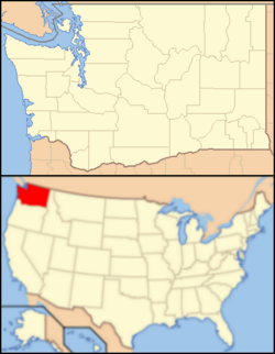
| Location | Washington State, USA |
| Range | Cascade Range |
| Prominence | 13,211 feet (4,027 m) Ranked 21st [3][4] |
| Coordinates | [5] |
| Topo map | USGS Mount Rainier West |
| Type | Stratovolcano |
| Volcanic arc/belt | Cascade Volcanic Arc |
| Age of rock | 500,000 years |
| Last eruption | 1894 [6] |
| First ascent | 1870 by Hazard Stevens and P. B. Van Trump |
| Easiest route | rock/ice climb via Disappointment Cleaver |
| Listing | Ultra U.S. state high point |
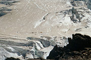
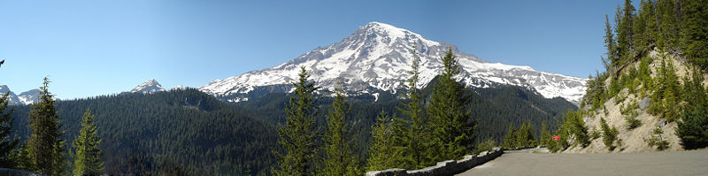
Mount Rainier is an active[7] stratovolcano (also known as a composite volcano) in Pierce County, Washington, located 54 miles (87 km) southeast of Seattle, Washington, in the United States. It is the highest peak in the Cascade Range and Cascade Volcanic Arc at 14,411 feet (4,392 m).[1][2] The mountain and the surrounding area are protected within Mount Rainier National Park. With 26 major glaciers, Mount Rainier is the most heavily glaciated peak in the lower 48 states with 35 square miles (91 km²) of permanent snowfields and glaciers. The summit is topped by two volcanic craters, each over 1,000 feet (300 m) in diameter with the larger east crater overlapping the west crater. Geothermal heat from the volcano keeps areas of both crater rims free of snow and ice, and has formed the world's largest volcanic glacier cave network within the ice-filled craters.[8] A small crater lake about 130 feet (40 m) by 30 feet (10 m) in size and 16 feet (5 m) deep, the highest in North America with a surface elevation of 14,203 feet (4,329 m), occupies the lowest portion of the west crater below more than 100 feet (30 m) of ice and is accessible only via the caves.[9] [10]
Mount Rainier has a topographic prominence of 13,210 feet (4,030 m), greater than that of K2 (13,189 feet (4,020 m)).[4] On clear days it dominates the southeastern horizon in most of the Seattle-Tacoma-Bellevue metropolitan area to such an extent that residents sometimes refer to it simply as "the Mountain."[11] On days of exceptional clarity, it can also be seen from as far away as Portland, Oregon, and Victoria, British Columbia.
The Carbon, Puyallup, Mowich, Nisqually, and Cowlitz Rivers begin at eponymous glaciers of Mount Rainier. The sources of the White River are Winthrop, Emmons, and Fryingpan Glaciers. The White, Carbon, and Mowich join the Puyallup River, which discharges into Commencement Bay at Tacoma; the Nisqually empties into Puget Sound east of Lacey; and the Cowlitz joins the Columbia River between Kelso and Longview.
Contents |
Geological history
Mount Rainier's earliest lavas are over 840,000 years old and are part of the Lily Formation (2.9 million to 840,000 years ago). The early lavas formed a "proto-Rainier" or an ancestral cone prior to the present-day cone. The present cone is over 500,000 years old.[12] The volcano is highly eroded, with glaciers on its slopes, and appears to be made mostly of andesite. Rainier likely once stood even higher than today at about 16,000 feet (4,900 m) before a major debris avalanche and the resulting Osceola Mudflow 5,000 years ago.


In the past, Rainier has had large debris avalanches, and has also produced enormous lahars (volcanic mudflows) due to the large amount of glacial ice present. Its lahars have reached all the way to Puget Sound. Around 5,000 years ago, a large chunk of the volcano slid away and that debris avalanche helped to produce the massive Osceola Mudflow, which went all the way to the site of present-day Tacoma and south Seattle.[13] This massive avalanche of rock and ice took out the top 1,600 feet (500 m) of Rainier, bringing its height down to around 14,100 feet (4,300 m). About 530 to 550 years ago, the Electron Mudflow occurred, although this was not as large-scale as the Osceola Mudflow.
After the major collapse 5,000 years ago, subsequent eruptions of lava and tephra built up the modern summit cone until about as recently as 1,000 years ago. As many as 11 Holocene tephra layers have been found.
The most recent recorded volcanic eruption was between 1820 and 1854, but many eyewitnesses reported eruptive activity in 1858, 1870, 1879, 1882 and 1894 as well.[14] As of 2008, there is no evidence of an imminent eruption. However, an eruption could be devastating for all surrounding areas of the volcano.
Lahars from Rainier pose the most risk to life and property, as many communities lie atop older lahar deposits. Not only is there much ice atop the volcano, the volcano is also slowly being weakened by hydrothermal activity. According to Geoff Clayton, a geologist with RH2, a repeat of the Osceola mudflow would destroy Enumclaw, Kent, Auburn, and most or all of Renton.[13] Such a mudflow might also reach down the Duwamish estuary and destroy parts of downtown Seattle, and cause tsunamis in Puget Sound and Lake Washington. According to USGS, about 150,000 people live on top of old lahar deposits of Rainier.[7] Rainier is also capable of producing pyroclastic flows as well as lava.
Human history

Mount Rainier was first known by the Native Americans as Talol, Tahoma, or Tacoma, from the Lushootseed word təqʷúʔbəʔ ("mother of waters") spoken by the Puyallup. Another interpretation is that "Tacoma", effectively means "larger than Koma (Kulshan)".[16] (a name for Mount Baker), cf. "Kobah" (Skagit: qwúbəʔ, "white sentinel", i.e. "mountain").[17]
At the time of European contact, the river valleys and other areas near the mountain were inhabited by many Pacific Northwest tribes who hunted and gathered berries in its forests and mountain meadows. These included the Nisqually, Cowlitz, Yakama, Puyallup, and Muckleshoot.

Captain George Vancouver reached Puget Sound in 1792 and became the first European to see the mountain. He named it in honor of his friend, Rear Admiral Peter Rainier.[19]
In 1833, Dr. William Fraser Tolmie explored the area looking for medicinal plants. Hazard Stevens and P. B. Van Trump received a hero's welcome in the streets of Olympia after their successful summit climb in 1870.[20][21] John Muir climbed Mount Rainier in 1888, and although he enjoyed the view, he conceded that it was best appreciated from below. Muir was one of many who advocated protecting the mountain. In 1893, the area was set aside as part of the Pacific Forest Reserve in order to protect its physical/economic resources: timber and watersheds.
Citing the need to also protect scenery and provide for public enjoyment, railroads and local businesses urged the creation of a national park in hopes of increased tourism. On March 2, 1899, President William McKinley established Mount Rainier National Park as America's fifth national park. Congress dedicated the new park "for the benefit and enjoyment of the people"[22] and "... for the preservation from injury or spoliation of all timber, mineral deposits, natural curiosities, or wonders within said park, and their retention in their natural condition."[23]
In 1998, the United States Geological Survey began putting together the Mount Rainier Volcano Lahar Warning System to assist in the emergency evacuation of the Puyallup River valley in the event of a catastrophic debris flow. It is now run by the Pierce County Department of Emergency Management. Tacoma, at the mouth of the Puyallup, is only 37 miles (60 km) west of Rainier, and moderately sized towns such as Puyallup and Orting are only 27 miles (43 km) and 20 miles (32 km) away, respectively.
Naming controversy
Although "Rainier" had been considered the official name of the mountain, Theodore Winthrop, in his posthumously published 1862 travel book The Canoe and the Saddle, claimed the indigenous name of the mountain was "Tacoma" and afterwards, both names were used interchangeably, although "Mt. Tacoma" was preferred in the city of Tacoma.[24]
In 1890, the United States Board on Geographic Names declared that the mountain would be known as "Rainier". Following this in 1897, the Pacific Forest Reserve became the Mount Rainier Forest Reserve, and the national park was established three years later. Despite this, there was still a movement to change the mountain's name to "Tacoma" and Congress was still considering a resolution to change the name as late as 1924.[24]
Subsidiary peaks

The broad top of Mount Rainier contains three named summits. The highest is called Columbia Crest. The second highest summit is Point Success, 14,158 feet (4,315 m), at the southern edge of the summit plateau, atop the ridge known as Success Cleaver. It has a topographic prominence of about 138 feet (42 m), so it is not considered a separate peak. The lowest of the three summits is Liberty Cap, 14,112 feet (4,301 m), at the northwestern edge, which overlooks Liberty Ridge, the Sunset Amphitheater, and the dramatic Willis Wall. Liberty Cap has a prominence of 492 feet (150 m), and so would qualify as a separate peak under most strictly prominence-based rules. A prominence cutoff of 400 feet (122 m) is commonly used in Washington state.[25] However it is not usually considered a separate peak, due to the massive size of Mount Rainier, relative to which a 492 foot (150 m) drop is not very large.
High on the eastern flank of Mount Rainier is a peak known as Little Tahoma Peak, 11,138 feet (3,395 m), an eroded remnant of the earlier, much higher, Mount Rainier. It has a prominence of 858 feet (262 m), and it is almost never climbed in direct conjunction with Columbia Crest, so it is usually considered a separate peak. If considered separately from Mt. Rainier, Little Tahoma Peak would be the third highest mountain peak in Washington.
Climbing and recreation
Mountain climbing on Mount Rainier is very difficult; it involves climbing on the largest glaciers in the U.S. south of Alaska. Most climbers require two to three days to reach the summit. Climbing teams require experience in glacier travel, self-rescue, and wilderness travel. About 8,000 to 13,000 people attempt the climb each year,[26] about 90% via routes from Camp Muir on the southeast flank.[27] Most of the rest ascend Emmons Glacier via Camp Schurman on the northeast. About half of the attempts are successful, with weather and conditioning being the most common reasons for failure.
About three mountaineering deaths each year occur due to rock and ice fall, avalanche, falls, and hypothermia associated with severe weather. The worst mountaineering accident on Mount Rainier occurred in 1981, when eleven people lost their lives in an ice fall on the Ingraham Glacier.[28] This was the largest number of fatalities on Mount Rainier in a single incident since 32 people were killed in a 1946 plane crash on the South Tahoma Glacier.[29]
Hiking, photography, and camping are popular in the park. Hiking trails, including the Wonderland Trail, a 93 miles (150 km) circumnavigation of the peak provide access to the backcountry. Mount Rainier is also popular for winter sports, including snowshoeing and cross-country skiing. In summer, visitors pass through vast meadows of wildflowers, on trails emanating from historic Paradise Inn.
Washington state quarter

The Washington state quarter, which was released on April 11 2007, features Mount Rainier and a salmon.[30][31]
See also
- Cascade Volcanoes
- Mount Rainier National Park
- List of Highest Mountain Peaks in Washington State
- Mountain peaks of North America
- Mountain peaks of the United States
References
- ↑ 1.0 1.1 Hill, Craig (2006-11-16). "Taking the measure of a mountain". The News Tribune. Retrieved on 2008-09-16.
- ↑ 2.0 2.1 Signani, PLS, Larry (July 19, 2000). "The Height of Accuracy". Point of Beginning (trade magazine) (BNP Media). http://www.pobonline.com/Articles/Features/1fc6f0b5ba0f6010VgnVCM100000f932a8c0____. Retrieved on 2008-10-17.
- ↑ "Mount Rainier". Peakbagger.com. Retrieved on 2008-10-17.
- ↑ 4.0 4.1 "World Top 50 by Prominence". www.peakbagger.com. Retrieved on 2008-11-05.
- ↑ "Mount Rainier". Geographic Names Information System. U.S. Geological Survey. Retrieved on 2008-10-15.
- ↑ Smithsonian Institution Global Volcanism Program: Rainier. Retrieved on 2008-08-27.
- ↑ 7.0 7.1 Driedger, C.L.; K.M. Scott (March 1, 2005). "Mount Rainier – Learning to Live with Volcanic Risk". Fact Sheet 034-02. U.S. Geological Survey. Retrieved on 2008-10-30.
- ↑ Zimbelman, D. R.; Rye, R. O., Landis, G. P. (2000). "Fumaroles in ice caves on the summit of Mount Rainier; preliminary stable isotope, gas, and geochemical studies". Journal of Volcanology and Geothermal Research 97 (1-4): 457-473.
- ↑ Kiver, Eugene P.; Mumma, Martin D. (1971). "Summit Firn Caves, Mount Rainier, Washington". Science 173 (3994): 320-322.
- ↑ Kiver, Eugene P.; Steele, William K. (1975). "Firn Caves in the Volcanic Craters of Mount Rainier, Washington" (abstract only). The NSS Bulletin 37 (3): 45-55. http://caves.org/pub/journal/PDF/V37/v37n3-Kiver.htm.
- ↑ Bruce Barcott (April 27 1999). "The Mountain is Out". Western Washington University. Retrieved on 2007-03-23.
- ↑ Sisson, T.W. (1995). History and Hazards of Mount Rainier, Washington. USGS. Open-File Report 95-642.
- ↑ 13.0 13.1 Parchman, F. (2005-10-19). "The Super Flood", Seattle Weekly.
- ↑ Harris, Stephen L. (2005). "Mount Rainier: America's Most Dangerous Volcano". Fire Mountains of the West (3rd edition ed.). Missoula, Montana: Mountain Press Publishing Company. pp. pp. 299-334. ISBN 0-87842-511-X.
- ↑ Winsey, H. J. (1888). The Great Northwest. St Paul, MN: Northern News Co. p. frontpiece.
- ↑ http://books.google.com/books?id=Z8-3KVL03UYC&printsec=frontcover
- ↑ http://books.google.com/books?id=3ek5uvZaNGIC&printsec=frontcover
- ↑ "Mowich" is the Chinook Jargon word for "deer"
- ↑ "Historical Notes: Vancouver's Voyage". Mount Rainier Nature Notes Vol. 7 (no. 14). 1929. http://www.nps.gov/archive/mora/notes/vol7-14e.htm. Retrieved on 2008-11-09.
- ↑ Haines, Aubrey L. (1999) [1962]. Mountain fever : historic conquests of Rainier. Original publisher: Oregon Historical Society; Republished by University of Washington. ISBN 0295978473.
- ↑ "Hazard Stevens photographs, c. 1840s-1918". University of Oregon Libraries Historic Photograph Collections. University of Oregon (March 2006). Retrieved on 2008-05-14.
- ↑ "U.S. Code: Title 16 Chapter 1 Subchapter XI § 91". Legal Information Institute, Cornell University Law School. Retrieved on 2008-10-30.
- ↑ "U.S. Code: Title 16 Chapter 1 Subchapter XI § 92". Legal Information Institute, Cornell University Law School. Retrieved on 2008-10-30.
- ↑ 24.0 24.1 "Rainier". Snopes (March 18 2007). Retrieved on 2007-11-30.
- ↑ John Roper; Jeff Howbert. "Washington 100 Highest Peaks with 400 feet of prominence". The Northwest Peakbaggers Asylum. Retrieved on 2007-03-23.
- ↑ "MORA Climbing Statistics". National Park Service (30 July, 2005). Archived from the original on 2006-01-01.
- ↑ "Camp Muir, Mount Rainier, Washington". University of Washington Libraries Digital Collections. University of Washington. Retrieved on 2007-09-12.
- ↑ Hatcher, Candy (2000-03-30). "Ghosts of Rainier: Icefall in 1981 entombed 11 climbers". Retrieved on 2008-11-09.
- ↑ "HistoryLink: A Curtis Commando R5C transport plane crashes into Mount Rainier, killing 32 U.S. Marines, on December 10, 1946". HistoryLink.org (29, 2006-07-29). Retrieved on 2008-11-09.
- ↑ "Governor Gregoire Announces Her Choice for Washington's Quarter". Washington State Quarter. Washington State Office of the Governor (2006-05-01). Retrieved on 2007-02-22.
- ↑ Green, Sara Jean (2007-04-12). "Washington quarter makes debut", The Seattle Times. Retrieved on 2007-04-12.
External links
- Mount Rainier National Park (also used as a reference)
- "Mount Rainier Volcano Lahar Warning System". Volcano Hazards Program. USGS. Retrieved on 2008-10-30.
- Mount Rainier stream drainage
- Mount Rainier Trail Descriptions
- Mountaineering routes (Summitpost)
- Mount Rainier National Park at the Open Directory Project
University of Washington Libraries, Digital Collections:
- Lawrence Denny Lindsley Photographs, Landscape and nature photography of Lawrence Denny Lindsley, including photographs of scenes around Mount Rainier.
- The Mountaineers Collection, Photographic albums and text documenting the Mountaineers official annual outings undertaken by club members from 1907-1951, includes 3 Mt. Rainier albums (ca. 1912, 1919, 1924).
- Henry M. Sarvant Photographs, photographs by Henry Mason Sarvant depicting his climbing expeditions to Mt. Rainier and scenes of the vicinity from 1892-1912.
- Alvin H. Waite Photographs Photographs of Mt. Rainier by Alvin H. Waite, during the late nineteenth and early twentieth centuries.
|
||||||||
|
||||||||||||||||
|
|||||
|
|||||