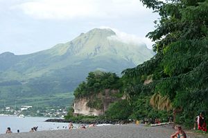
Mount Pelée
| Mount Pelée | |
|---|---|
 |
|
| Elevation | 1,397 metres (4,583 ft)[1] |
| Location | Martinique |
| Type | Stratovolcano |
| Last eruption | 1932 [1] |
| Easiest route | Walk |
Mount Pelée (pronounced /pəˈleɪ/; French: Montagne Pelée "Bald Mountain") is a dormant volcano on the northern tip of the French overseas department of Martinique in the Lesser Antilles island arc of the Carribean. It is among the deadliest stratovolcanos on Earth; its volcanic cone composed of layers of volcanic ash and hardened lava.[2]
Mount Pelée is famous for its extremely destructive eruption in 1902 and the destruction that resulted, now dubbed the worst volcanic disaster of the 20th century.[3][4] The eruption killed about 30,000 people,[5][6] most deaths in the destroyed Saint-Pierre, at that time the largest city in Martinique, due to its deadly pyroclastic flows.[7][8] Pyroclastic flows completely destroyed St. Pierre, Martinique, a town of 30,000 people, following the eruption of Mont Pelée in 1902.[9] The eruption left only two survivors in the direct path of the volcano, one alive because he was in a poorly ventilated, dungeon-like jail cell and the other, living on the edge of the city, escaped with severe burns.[10] Mount Pelee is made up mostly of pyroclastic material. This was a massive devastation to France, as it had not had a major volcanic eruption before this time.
Contents |
Geographical setting
The volcano lies within the Lesser Antilles, an island arc within the Carribean Sea.
Geography
Mount Pelee itself is the result of a typical island arc, a curved chain of volcanoes approximately 530 miles (850 km) in length, between Puerto Rico and Venezuela, where the Caribbean plate meets the Atlantic plate. The Atlantic plate slips under the Caribbean plate at intervals from 1 to 2 cm/year, and dips into the mantle.[2][11] Partial fusion of the plate along with sediments forms the magma feeding the volcanoes of the Lesser Antilles. This process is also responsible for the seismicity of that region.
Other volcanoes in the region are also known for their volcanic activity, including Saint Vincent's La Soufrière, Guadeloupe's Soufriere volcano, Montserrat's Soufrière Hills, and the submarine volcano.[2]
The Mount Pelee known today is the result of a morph completed in three stages spanning hundreds of thousands of years, initial, intermediate, and modern.[2] In an initial phase, called the "Paléo-Pelée" stage, Mount Pelee was a common stratovolcano. The cone of Paleo-Pelée is composed of many layers of lava flows and fragmented volcanic debris. Remains of the Paleo-Pelée cone are still visible at the northern view at the volcano today.
A second stage, now called the intermediate phase, started around 100,000 years ago, after a long period of quiescence. This stage is grouped by the formation of the Morne Macouba lava dome, then later on, the Morne Macouba caldera. During the intermediate phase, there were several eruptions which produced pyroclastic flows like those that destroyed Saint-Pierre in the 1902 eruption. Around 25,000 years ago, a large Southwest sector collapse occurred, forming a landslide This event is similar to the eruption of Mount Saint Helens in 1980.[2]
The modern stage of the evolution of Mount Pelee has created most of the current cone, with desposits of pumice and the results of past pyroclastic flows. More than 30 eruptions have been identified during the last 5,000 years of the volcano's activity.
3,000 years ago, following a large pumice eruption, the Etang Sec caldera was then formed. The 1902 eruption took place within the Etang Sec crater. This eruption formed many pyroclastic flows and produced a dome which filled the caldera.
The following eruption in 1929 formed a second dome in the Etang Sec caldera, and produced pyroclastic flows emptying into the Blanche River valley. This last eruption is mainly responsible for the current state of Mount Pelée.[2]
1902 eruption

Before the tragic 1902 eruption, as early as the summer of 1900, signs of increased fumarole activity were present in the Étang Sec crater near the summit. [12] Relatively minor phreatic (steam) eruptions that occurred in 1792 and 1851 were evidence that the volcano was active and potentially dangerous. Local natives, the Carib people, knew it as "fire mountain" from previous eruptions in ancient times.
Though it was previously dormant, at least in living memory, Mount Pelée began its eruptions on April 25, 1902. In early April, excursionists noted the appearance of sulfurous vapors emitting from fumaroles near the mountaintop. This was not regarded as important, as fumaroles had been appearing and disappearing in the past.
On April 23, the mountain caused a light rain of cinders on its southern and western side, together with sharp underground shocks.
On April 25, the mountain emitted a large cloud containing rocks and ashes from its top, where the Étang Sec - a dry basin - was located. The ejected material did not cause a meaningful amount of damage.
On April 26, the area was dusted by volcanic ash from a next eruption; the public authorities still did not see a reason to worry.
On April 27, several excursionists climbed the mountaintop to find Étang Sec filled with water, forming a lake 180 meters across. There was a 15 meter high cone of volcanic debris built up on one side, feeding the lake with a steady stream of boiling water. Sounds resembling a cauldron with boiling water were heard from deep underground. The strong smell of sulfur was all over the city, 4 miles (6.4 km) away from the volcano, causing discomfort to people and horses.
On April 30, the rivers Roxelane and Rivière des Pères swelled, carrying boulders and trees from the mountaintop. The villages of Prêcheur and Ste. Philomène were receiving a steady stream of ashes.

At 11:30 p.m. on May 2, the mountain produced loud detonations, earthquakes, and a massive pillar of dense black smoke. Ashes and fine-grained pumice covered the entire northern half of the island. The detonation continued in 5-6 hour intervals. This led the local newspaper Les Colonies to indefinitely postpone the proposed picnic on the mountain, originally planned for May 4. Farm animals started dying from hunger and thirst, as their sources of water and food were contaminated with ash.
On Saturday, May 3, the wind blew the ash cloud northwards, alleviating the situation in St Pierre. The next day the ash fall intensified, and the communication between St Pierre and the Precheur district was severed. The ash cloud was so dense that the coastal boats feared to navigate through it. Many citizens decided to evacuate, filling the capacity of the steamer lines. The area was covered with a layer of fine, flour-like white ash. The animals, wild and domestic alike, were growing restless; the Guérin Sugar Works, two miles (3 km) northwest of St. Pierre, was invaded by a great swarm of speckled ants and foot-long centipedes, which bit unfortunate horses while workers tried to subdue the frenzied insects. In St. Pierre, hundreds of restless fer-de-lance snakes slithered through the streets, biting anybody who did not stay out of their paths. Soldiers were called in to shoot the snakes, although not before a number of humans and domestic animals were killed by the snakes.

On Monday, May 5, the mountain apparently calmed down somewhat; however, at about 1 PM, the sea suddenly receded about 100 meters and then rushed back, flooding parts of the city, and a large cloud of smoke appeared westwards of the mountain. One wall of the Étang Sec crater collapsed and propelled a mass of boiling water and mud, or lahar, into Riviere Blanche, flooding the Guérin sugar works and burying about 150 victims under 60 to 90 meters of mud. Refugees from other areas rushed into St Pierre. That night, the atmospheric disturbances disabled the electric grid, sinking the city into darkness and adding to the confusion.
The next day, at about 2 AM, loud sounds were heard from within the depth of the mountain.
On Wednesday, May 7, at around 4 AM, the mountain stepped up its activity; the clouds of ash caused numerous lightnings around the mountaintop, and both the craters glowed reddish orange into the night. Through the day, people were leaving the city, but more people from the countryside were attempting to find refuge in the city, increasing its population by several thousand. The newspapers still claimed the city was safe. News of the volcano Soufrière erupting on the nearby St. Vincent island reassured the people that the internal pressures in the mountain were being relieved. Not everyone was reassured, though; Captain Marina Leboffe, of the barque Orsolina, left the harbor with only half of the sugar cargo loaded, despite shippers' protests, clearance refused by the port authorities, and threats of being arrested, as were many other civilians refused exit of the town.[10] However, Governor Louis Mouttet and his lady stayed in the city. By the evening, the mountain's tremors seemed to calm down again.

The main eruption
On May 8th, 1902, on the Ascension Day, a volcanic eruption destroyed the town of Saint-Pierre, about 4 miles (6.4 km) south of the peak.
In the morning, people were observing the fireworks the mountain was displaying. The night shift telegraph operator was sending the reports of the volcano's activity, to the operator at Fort-de-France, claiming no significant new developments; his last transmission was "Allez", handing over the line to the remote operator. It was 7:52; the next second, the telegraph line went dead. A cable repair ship had the city in direct view; the upper mountainside ripped open and a dense black cloud shot out horizontally.[10] A second black cloud rolled upwards, forming a gigantic mushroom cloud and darkening the sky in a 50-mile (80 km) radius. The initial speed of both clouds was later calculated to be over 670 kilometers per hour.
The horizontal pyroclastic cloud hugged the ground and sped down towards the city of Saint Pierre, appearing black and heavy, glowing hot from the inside. It consisted of superheated steam and volcanic gases and dust, with temperatures exceeding 1075 °C. In under a minute it reached and covered the entire city, instantly igniting everything combustible it came in contact with.
A rush of wind followed, this time towards the mountain. Then came a half-hour downpour of muddy rain mixed with ashes. For the next several hours, all communication with the city was severed. Nobody knew what was happening, nor who had authority over the island, as the governor was unreachable and his status unknown. Some survivors were picked from the sea, mostly badly burned sailors who had been blown into the sea by the blast and then clung for hours to floating debris.
There are unnamed eyewitnesses to the eruption, probably survivors on the boats at the time of the eruption. One eyewitness said "the mountain was blown to pieces, there was no warning", while another said "it was like a giant oil refinery". One person even went as far to say that "the town vanished before our eyes."[13]
A warship approached the shore at about 12:30, but the intense heat prevented it from landing until about 3 PM. The city burned for several more days.
The area devastated by the pyroclastic cloud covered about 8 square miles (21 km2), with the city of St. Pierre taking its brunt.
At the time of the eruption, Saint Pierre had a population of about 30,000, which was swelled by refugees from the minor explosions and mud flows first emitted by the volcano. Out of the 30,000, there were only two survivors: Louis-Auguste Cyparis, a felon held in an underground cell in the town's jail for wounding a friend with a cutlass, and Léon Compère-Léandre, a man who lived at the edge of the city.[10] Compere-Leandre stated the following when asked about his survival:
"I felt a terrible wind blowing, the earth began to tremble, and the sky suddenly became dark. I turned to go into the house, with great difficultuy climbed the three or four steps that separated me from my room, and felt my arms and legs burning, also my body. I dropped upon a table. At this moment four others sought refuge in my room, crying and writhing with pain, although their garmets showed no sign of having been touched by flame. At the end of 10 minutes one of these, the young Delavaud girl, aged about 10 years, fell dead; the others left. I got up and went to another room, where I found the father Delavaud, still clothed and lying on the bed, dead. He was purple and inflated, but the clothing was intact. Crazed and almost overcome, I threw myself on a bed, inert and awaiting death. My senses returned to me in perhaps an hour, when I beheld the roof burning. With sufficient strength left, my legs bleeding and covered with burns, I ran to Fonds-Sait-Denis, six kilometers from St. Pierre."[10]
One woman, a housemaid, also survived the pyroclastic flow but perished soon after; the only thing she remembered from the event was sudden heat. She died very shortly after being discovered. Included among the victims were the passengers and crews of several ships docked at Saint Pierre.
One passenger steamship, the Roraima, which went missing on April 26, was believed to have been engulfed by ash from a preliminary explosion. However, it reached the port of Saint Pierre at 6:30 AM, shortly before the eruption, and was set aflame by the nuée ardente. It later sank; its wreck is still present offshore of Saint Pierre; 28 of her crew, and all the passengers, except two, were killed by the cloud.[10]
Subsequent Activity

Mount Pelée continued to erupt until July 4, 1905.[14]
- On May 20, a second eruption equal to the first one in both type and force obliterated what was left of St Pierre.
- During a powerful eruption on August 30, 1902, a pyroclastic flow extended further east than the flows of 8 and 20 May. Although not quite as powerful as the previous two eruptions, the August 30 pyroclastic flow struck Morne Rouge (at least 800 fatalities), Ajoupa-Bouillon (250 fatalities), and parts of Basse-Pointe (25 fatalities) and Morne-Capot (10 fatalities). This was the last fatal eruption of Mount Pelée until the present time.[15]
The study of the causes of the disaster marks the beginning of modern volcanology with the definition and the analysis of the deadliest volcanic hazard: the pyroclastic flows and surges, also called "nuées ardentes" (Fr: burning clouds). The eruption has also lent its name to the "Pelean eruption style". Among those who studied Mount Pelée were Angelo Heilprin and Antoine Lacroix. The illustrious Lacroix was the first to meticulously describe the "nuée ardente" phenomenon.[16]
The destruction caused by the 1902 eruption was quickly publicized by recent modern means of communication. It brought to the attention of the public and governments the hazards and dangers of an active volcano. Many people had perished in a flash not even a reflex to move.The pyroclatic flow had swallowed the town and the people inside.
Volcanic Spine
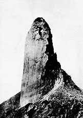
Beginning in October 1902, a dramatic volcanic spine grew from the crater floor in the Étang Sec crater, reaching a maximum width of 300-500 feet and a height of 305 meters (1000 ft). Called the "Needle of Pelée" or "Pelee's Tower", this extraordinary volcanic feature collapsed during 1903.[17] Sometimes, the volcano would rise up to 50 feet (15 m) a day, and became twice the height of the Washington Monument and more or less the same volume as the Great Pyramid of Egypt. It finally became unstable and collapsed into a pile of rubble in March 1903, after 11 months of growth. No geologist had ever witnessed a volcanic spine of such magnitude before. [10]
Current status
As of 2006, the volcano currently lies silent above Saint Pierre and Martinique. Before the 1902 eruption — as early as the summer of 1900 — signs of increased fumarole activity were present in the Étang Sec crater (Scarth, p.30). Relatively minor phreatic (steam) eruptions that occurred in 1792 and 1851 were evidence that the volcano was active. Signs of unrest will almost certainly precede any future eruptive activity from Mt. Pelée, and its past activity (including the violent eruptions uncovered by carbon dating) is an extremely important factor for hazard assessment.[18]
During the May 8, 1902 eruption, 2 individuals survived out of the population of about 30,000 people in Saint-Pierre. Others died in areas near the city[19] and many perished on ships in the harbor. Pelée is one of the most active volcanoes in the West Indies and it is possible it might erupt again. Currently, Mount Pelée is under continuous watch by geophysicists and volcanologists (IPGP).
See also
- List of volcanoes in Martinique
- Mount Vesuvius
- Mount Pinatubo
References
- ↑ 1.0 1.1 "Pelée". Global Volcanism Program. Smithsonian Institution. Retrieved on 2008-12-06.
- ↑ 2.0 2.1 2.2 2.3 2.4 2.5 "Mount Pelee". Mount-pelee.com.
- ↑ Wright, Pierson (1992). USGS Circular 1073. USGS. pp. p. 39.
- ↑ Tilling (1985). Volcanoes. USGS. p. p. 16-17.
- ↑ "USGS document of the 1902 eruption of Mount Pelee". USGS.
- ↑ Tilling (1985). Volcanoes. USGS.
- ↑ Blong, R.J. (1984). Volcanic Hazards: A Sourcebook on the Effects of Eruptions. Orlando, Florida: Academic Press.
- ↑ Wright,Pierson (1992). Living With Volcanoes: USGS Circular 1073. USGS.
- ↑ Heilprin (1908). The eruption of Mt. Pelee p.72. Philadelphia: Philadelphia Geographic Society.
- ↑ 10.0 10.1 10.2 10.3 10.4 10.5 10.6 "The eruption of Mount Pelee". SDSU.
- ↑ "Mount Pelee, Martinique 1902". GeoCities.
- ↑ Scarth, Alwyn (2002). 'La Catastrophe'. Oxford. pp. p. 30.
- ↑ Staff. "Mt. Pelee". Windows to the universe.
- ↑ Scarth, Alwyn (2002). 'La Catastrophe'. Oxford. pp. p. 221.
- ↑ Scarth, Alwyn (2002). 'La Catastrophe'. Oxford. pp. p. 212-218.
- ↑ Scarth, Alwyn (2002). 'La Catastrophe'. Oxford. pp. p. 207.
- ↑ Scarth, Alwyn (2002). 'La Catastrophe'. Oxford. pp. p. 219-221.
- ↑ "Global Volcanism Program | Pelee | Eruptive History". National Museum of Natural History, Smithsonian Institution.
- ↑ Scarth, Alwyn (2002). 'La Catastrophe'. Oxford. pp. p. 176.