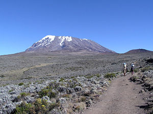
Mount Kilimanjaro
| Mount Kilimanjaro | |
|---|---|
 Kibo Summit of Kilimanjaro |
|
 Mount Kilimanjaro
|
|
| Elevation | 5,895 metres (19,341 ft) |
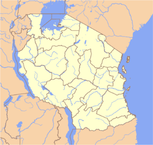
| Location | Tanzania |
| Prominence | 5,885 m (19,308 ft) Ranked 4th |
| Coordinates | |
| Topo map | Kilimanjaro map and guide by Wielochowski [1] |
| Type | Stratovolcano |
| Last eruption | None in recorded history |
| First ascent | 1889 by Hans Meyer, Ludwig Purtscheller, Yohanas Kinyala Lauwo |
| Easiest route | hike |
| Listing | Seven Summits Country high point Ultra |
Kilimanjaro with its three volcanic cones, Kibo, Mawenzi, and Shira, is an inactive stratovolcano in north-eastern Tanzania[2] rising 4,600 m (15,100 ft) from its base, and is additionally the highest peak in Africa at 5,895 meters (19,340 ft), providing a dramatic view of the surrounding plains.
Contents |
Description

The highest point on Kilimanjaro is Uhuru Peak, on the volcano Kibo 5,895 metres (19,341 ft). The top of Kibo is a 1.5 mile wide crater. As the highest point in Africa Uhuru Peak is one of the Seven Summits. The summit was first reached by the Marangu army scout Yohanas Kinyala Lauwo, German Hans Meyer and Austrian Ludwig Purtscheller, on October 6, 1889. Two other peaks are also dormant volcanoes: Mawenzi (5,149 m, 16,890 ft), the third highest peak in Africa (after Mount Kenya) and Shira (3,962 m, 13,000 ft). Yohanas' Notch is named after Lauwo.
Due to Kilimanjaro's equatorial location and high elevation, almost every climate type on earth is represented, including a year-round snow-topped summit.
The summit of Kilimanjaro is covered by a GSM mobile phone network, provided by Vodacom It was previously the highest point in the world with mobile phone service; China Mobile now provides coverage at the top of Mt. Everest.
Current conditions
Climatic conditions
While the volcano appears to be dormant on the inside, events on top of the mountain draw global attention. The top of the mountain has seen a retreat of the most recent covering of glaciers[3], with the most recent ice cap volume dropping by more than 80% [4].
Sources disagree when the glaciers will be gone due to melting. In 2002, a study led by Ohio State University ice core paleoclimatologist Lonnie Thompson [5] predicted that ice on top of Africa's tallest peak would be gone between 2015 and 2020 [6] [7]. In 2007, a team of Austrian scientists from University of Innsbruck predicted that the plateau ice cap will be gone by 2040, but some ice on the slope will remain longer due to local weather conditions [8]. Yet, another, the California Academy of Sciences, predicts that the [glaciers] will be gone by 2050[9]. A comparison of ice core records suggests conditions today are returning to those of 11,000 years ago. A study by Philip Mote of the University of Washington in the United States and Georg Kaser of the University of Innsbruck in Austria concludes that the shrinking of Kilimanjaro's ice cap is not directly due to rising temperature but rather to decreased precipitation. [10] In May 2008 The Tanzanian Minister for Natural Resources, Ms Shamsa Mwangunga, said that there were indications that snow cover on the mountain was actually increasing.[11] As of January 2006, the Western Breach route has been closed by the Tanzanian government following a rockslide that killed four people at Arrow Glacier Camp.

Volcanic Conditions
While it is inactive, Kilimanjaro has fumaroles that emit gas in the crater on the main summit of Kibo. Scientists concluded in 2003 that molten magma is just 400 metres (1,300 ft) below the summit crater. Several collapses and landslides have occurred on Kibo in the past, one creating the area known as the western breach.

Mapping
Early good maps of Kilimanjaro were published by the British Government's Directorate of Overseas Surveys (DOS 422 Y742) in 1963. These were based on air photography carried out as early as 1958 by the RAF. These were on a scale of 1:50,000 with contours at 100 ft intervals. These are now unavailable. Tourist mapping was first published by the Ordnance Survey in England in 1989 based on the original DOS mapping (1:100,000, 100ft intervals, DOS 522). This is now no longer available. EWP produced a map with tourist information in 1990 (1:75,000, 100m contour intervals, inset maps of Kibo and Mawenzi on 1:20,000 and 1:30,000 scales respectively and 50m contour interval). This is regularly updated and in its 4th edition. In the last few years numerous other maps have become available of various qualities. [1]
EWP map sample (1:75,000, summit area). [1]
Physical Features
Mount Kilimanjaro is one of the largest stratovolcanoes in the world. Otherwise known as a composite volcano, it comprises of numerous layers of lava, tephra and volcanic ash. Tephra is rhyolitic (an igneous, extrusive rock) in composition, and is formed by air-fall material of an eruption, which suggests the composite volcano was once active. However, at the moment it is dormant. According to experts there have been no eruptions in living memory, which suggests it has been dormant for millions of years.
Mount Kilimanjaro is in the shape of a conical volcano; it is formed by ejecta being thrown up by the volcano vent, which then piles around the vent in the shape of a cone. Due to the fact that Mount Kilimanjaro is made up of tephra, it has a cinder cone. This is because the mountains cone is made up of tephra cinders. They are made up of blobs of congealed lava and particles. When the mountain did erupt millions of years ago, the gas-charged lava would be blown violently into the air, then breaking the smaller fragments which would solidify and fall as cinders. This left Mount Kilimanjaro with a bowl-shaped crater. Moreover, as Mount Kilimanjaro is a stratovolcanoe then they can have explosive eruptions. The lava from the mountain is viscous (it’s a measure of the thickness of a fluid which is deformed by shear stress or extensional stress) which cools down before it spreads very far, which explains the mountains small crater. The rock on the mountain is felsic and has high levels of silica (in this case tephra). It is also in alternating sectors, with lava flows and ejecta in different formations. This is called stratum, which is usually formed by natural forces i.e. volcanic eruptions from Mount Kilimanjaro.
The volcano is the highest in Africa reaching 5,895m high. It also covers an area of 388, 500ha. Although the volcano stands alone, it is a part of an east-west belt of volcanoes stretching over Northern Tanzania. It has three main concentric cones to the southeast in the mountain, but also has smaller parasitic cones. Also known as a satellite cone, the main vent is blocked by cooled solidified lava, and the lava is then forced out through the sides of a volcano under immense pressure. To the west side of the mountain is the peak Shira (3,962m), of which only the southern and western rims remain.
In addition to the west there is also a flat tableland. On the edges of this material is later material made by the former eruptions of the mountain, and so it’s a dissected plateau. This is a plateau which has been uplifted by volcanic activity, then been severely eroded, which explains the material around the edge of the plateau. The peak of Mawenzi (5,149m) - which is rugged and erosion-shattered- can be found in the east of the volcano. Its western face has many features: crags, pinnacles and dyke swarms. Crags are a steeped mass of rock projecting upward or outward. Pinnacles are high peaks or points of rock, but in Mount Kilimanjaros case then it’s a high point of rock. A dike (plural dyke swarm) is a type of sheet intrusion that cuts discordantly across. These come in several forms: planar wall rock structures or massive rock formations. On Mawenzi these are formed in igneous intrusions. These form in high aspect ratios, so the thickness is smaller than the other 2 dimensions. The dykes intrude into a cross-cutting fissure. These are linear volcanic vents through which lava erupts, although Mount Kilimanjaro is dormant so it does not happen.
To the eastern side of Mawenzi it falls into cliffs, with a complex system of gullies and rock faces. These rises from two massive gorges: the Great Barranco and Lesser Barranco. Gorges are deep valleys between cliffs that are formed by erosion, and were formed from the plateau that can be found to the eastern side of the mountain. The cliffs form because harder rock strata that are resistant to erosion/weathering remain exposed on the valley walls. The most recent summit is Kibo (5,895m) which was last active during the Pleistocene. There are still even fumaroles. Even though there haven’t been eruptions for millions of years, there are openings near Kobe in the Earth’s crust which emits steam and gases e.g. Carbon Dioxide, Hydrochloric Acid. It even emits solfatara (Sulphurous gages). They occur along the chaotic clusters and long fissures. The hot igneous rocks react with the groundwater, which makes it release gases.
The highest point on the mountain is the southern rim of the outer crater. Moreover, between Kibo and Mawenzi is the Saddle, in which it contains high altitude tundra. This type of vegetation forms at high levels of altitude because tree growth is hindered by low temperatures and short growing seasons. There is a wide range of vegetation despite being at high altitude such as dwarf shrubs, grasses, mosses and lichens. The ecotone (difference between tundra and forest) is called the timberland. On Mount Kilimanjaro there are radial valleys that can be found on the southern and eastern slopes. They are smaller valleys that flank the mountains main valleys.
Name
It is unknown where the name Kilimanjaro comes from, but a number of theories exist. European explorers had adopted the name by 1860 and reported that it was its Swahili name,[12] that Kilimanjaro breaks Kilima (Swahili for "hill, little mountain") and Njaro,[13] whose supposed origin varies according to the theories—according to some it's an ancient Swahili word for white or for shining,[14] or for the non-Swahili origin, a word from the Kichagga language, the word jaro meaning caravan. The problem with all these is that they can't explain why the diminutive kilima is used instead of the proper word for mountain, mlima. A different approach is to assume that it comes from the Kichagga kilmanare or kileajao meaning "which defeats the bird/leopard/caravan". However this theory can't explain the fact that Kilimanjaro was never used in Kichagga before in Europe in the mid-1800s.[12]
In the 1880s the mountain, called Kilmanscharo in German, became a part of German East Africa after Karl Peters had persuaded local chiefs to sign treaties (a common story that Queen Victoria gave the mountain to Kaiser Wilhelm II is not true).[15] In 1889 Uhuru Peak on Kibo was named Kaiser-Wilhelm-Spitze,[12] which was used in the German Empire until its defeat in 1918, when the territory became British-administered Tanganyika and the name was discontinued. Because of global warming Kilimanjaro's glaciers are melting faster then ever before.
National Parks in the Kilimanjaro area
- Kilimanjaro National Park covers 753 km² of the mountain, and is a UNESCO World Heritage site.
- Amboseli National Park, Kenya is on the northern side.
- Tsavo National Park, Kenya lies to the east.
- Arusha National Park covers neighbouring Mt Meru.
Trekking routes up Kilimanjaro
There are several routes by which to climb Mt Kilimanjaro, namely, Marangu, Rongai, Lemosho, Shira, Umbwe and Machame. Of all the routes, Machame is by far the most scenic albeit steeper route up the mountain. The Rongai is the easiest camping route and the Marangu is also easy, but accommodation is in huts. As a result, this route tends to be very busy and ascent and descent routes are the same.
Persons wishing to climb Mt Kilimanjaro are advised to undertake appropriate research and ensure that they are both properly equipped and physically capable. Though the climb is technically very easy, the altitude and low temperature make this a difficult and dangerous trek. Acclimatisation is essential, and even then most people suffer some degree of altitude sickness. About 10 climbers die from this each year, together with an unknown number of local porters - figures for these are guessed at between 10-20. Kilimanjaro summit is well above the altitude at which high altitude pulmonary edema (HAPE), or high altitude cerebral edema (HACE) can occur. All climbers will suffer considerable discomfort, typically shortage of breath, hypothermia and headaches, and though most young, fit people can make the Uhuru summit, a substantial number of trekers will abandon the attempt at a lower altitude.
High altitude climbing clubs have criticised the Tanzanian authorities for charging fees for each day spent on the mountain. This can encourage climbers to climb rapidly to save time and money, while proper acclimatisation demands that delays are built in to any high climb.
Tanzanian Medical Services around the mountain have expressed concern recently over the current influx of tourists that apparently percieve Kilimanjaro as an easy climb. Many individuals require significant medical attention during their attempts, and many are forced to abandon the climb. An investigation into the matter concluded that tourists visiting Tanzania were often encouraged to join groups heading up the mountain without being made aware of the significant physical demands the climb makes.
In 1988 the first snowboard descent of Kilimanjaro was accomplished by a Canadian, Ace Bailey. Since then "pleasure devices" have been banned on the mountain. This includes skis, snowboards, parachutes and flying devices.
Unique vegetation
Kilimanjaro has unique vegetation such as the water holding cabbage in the tussock grassland and other plants like this, all adapted to living in alpine conditions.
See also
- List of volcanoes in Tanzania
- Furtwängler Glacier
- Rebmann Glacier
- Kilimanjaro National Park
- Tanzania - the nation containing Kilimanjaro, bordering on Kenya.
- Mount Kenya - a collapsed stratovolcano 200 miles (320 km) due north, in Kenya.
- Mount Kilimanjaro climbing routes
References
- ↑ 1.0 1.1 EWP. Kilimanjaro Map and tourist Guide [map], 4th edition, 1:75,000 with 1:20,000 and 1:30,000 insets, EWP Map Guides. Cartography by EWP. (1995) ISBN 0-906227-66-6.
- ↑ The concept of "free-standing rise" is not completely well-defined; however one definition characterizes it as the rise of the summit over the lowest closed contour line encircling and remaining near the summit. (Compare topographic prominence.) Kilimanjaro is encircled by a contour line at elevation 1,395 metres (4,577 ft), giving a rise of 4,500 metres (14,764 ft), which goes no further than 45 kilometres (28 mi) from the summit. This is the world's highest free-standing rise attainable within a 50 kilometres (31 mi) radius. Higher rises are attainable over somewhat larger distances, namely for Pico Cristóbal Colón, which rises 5,000 metres (16,400 ft) above a contour within 75 kilometres (47 mi), and Mount McKinley, which rises 5,300 metres (17,390 ft) above a contour within 120 kilometres (70 mi). (Sources: SRTM data, USGS National Elevation Dataset.) If points below sea level are considered, Mauna Kea beats Mount McKinley by hundreds of meters with a similar radius. (Source: USGS National Elevation Dataset and Geologic Investigations Series I-2809.)
- ↑ Recession of Equatorial Glaciers. A Photo Documentation, Hastenrath, S., 2008, Sundog Publishing, Madison, WI, ISBN-13: 978-0-9729033-3-2, 144 pp.
- ↑ Melting snows of Kilimanjaro
- ↑ Ice Man: Lonnie Thompson Scales the Peaks for Science
- ↑
 Mount Kilimanjaro seen from the air, with Mt Meru beyondIce core analysis reveals droughts
 Relief of Kilimanjaro
 - ↑ Ice Core Records
- ↑ Kilimanjaro's ice set to linger
- ↑ Video clip shown at the Clifornia Academy of Sciences, title unknown. 8 August 2008
- ↑ Geotimes - August 2007 - No more “snows of Kilimanjaro”?
- ↑ Tanzania: Minister - Ice Won't Vanish On Kili "The Citizen" May 26, 2008
- ↑ 12.0 12.1 12.2 Hutchinson, J. A.: The Meaning of Kilimanjaro
- ↑ "Kilima-Njaro" (alternate name in 1907), The Nuttall Encyclopædia, 1907, FromOldBooks.com, 2006, webpage: FOB-Njaro.
- ↑ "SRTM TANZANIA IMAGES" (Kilimanjaro or Kilima Njaro description), NASA, August 28, 2005, webpage: NASA-Tanzania.
- ↑ Briggs, Philip (1996): "Guide to Tanzania; 2nd edition." Bradt Guides.
- http://www.ewpnet.com/kilimanjaro.htm
- http://maps.google.co.uk/maps?hl=en&tab=wl
- http://www.peakware.com/peaks.html?pk=139
- http://library.thinkquest.org/16645/the_land/mount_kilimanjaro.shtml
- http://www.google.co.uk/search?hl=en&defl=en&q=define:Crags&sa=X&oi=glossary_definition&ct=title
- http://www.unep-wcmc.org/sites/wh/kilimanj.html
- http://www.memphisgeology.org/glossary_oq.htm
External links
- Mount Kilimanjaro on TierraWiki: Trails, Trip Reports, and GPS Routes.
- Mount Kilimanjaro Climbing Routes & Descriptions
- Mount Kilimanjaro National Park
- Volcano World
- Ohio State University study expedition to Kilimanjaro's glaciers
- NASA Earth Explorer page
- Latest news on all-things Kilimanjaro
- Comprehensive information on the Western Breach; including accident and current route status details
- Glacial recession of Southern Icefields
- Kilimanjaro Climbs: Free Advice and Information for anyone looking to climb Kilimanjaro.
- Climbing Kilimanjaro: Information on climbing Kilimanjaro.
- Flora of Kilimanjaro
- Alternative Tourist Map of Kilimanjaro
- Documentary "The Snows of Kilimanjaro" First seriesSecond series 2006 release TV-channel "Inter", Ukraine (Ukrainian)
|
|||||
|
|||||