Mount Hood
| Mount Hood | |
|---|---|
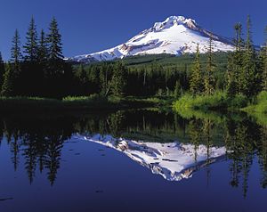 Mount Hood reflected in Trillium Lake |
|
 Mount Hood
|
|
| Elevation | 11,249 feet (3,429 m) NAVD 88 [1] |
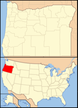
| Location | Oregon, USA |
| Range | Cascade Range |
| Prominence | 7,706 feet (2,349 m) [2] |
| Coordinates | [1] |
| Topo map | USGS Mount Hood South 45121-C6 |
| Type | Stratovolcano |
| Volcanic arc/belt | Cascade Volcanic Arc |
| Age of rock | Less than 500,000 years [3] |
| Last eruption | 1790s [3] |
| First ascent | 1857-07-11 by Henry Pittock, W. Lymen Chittenden, Wilbur Cornell, and the Rev. T.A. Wood [4] |
| Easiest route | Rock and glacier climb |
| Listing | Ultra U.S. state high point |
Mount Hood, called Wy'east by the Multnomah tribe, is a stratovolcano in the Cascade Volcanic Arc of northern Oregon, in the Pacific Northwest region of the United States. It is located about 50 miles (80 km) east-southeast of the city of Portland, on the border between Clackamas and Hood River counties.
Mount Hood's snow-covered peak rises 11,249 feet (3,429 m)[1] and is home to twelve glaciers.[5] (Older surveys said 11,239 feet (3,426 m), which is still often cited as its height). It is the highest mountain in Oregon and the fourth-highest in the Cascade Range.[6] Mount Hood is considered the Oregon volcano most likely to erupt,[7] though based on its history, an explosive eruption is unlikely. Still, the odds of an eruption in the next 30 years are estimated at between 3 and 7 percent,[8] so the USGS characterizes it as "potentially active", but the mountain is informally considered dormant.[8]
Contents |
Facilities
Timberline Lodge is a National Historic Landmark located on the southern flank of Mount Hood just below Palmer Glacier.[9]
The mountain has six ski areas: Timberline, Mount Hood Meadows, Ski Bowl, Cooper Spur, Snow Bunny and Summit. They total over 4,600 acres (7.2 sq mi/18.6 km²) of skiable terrain; Timberline offers the only year-round lift-served skiing in North America.[10]
Mount Hood is part of the Mount Hood National Forest, which has 1.067 million acres (1667 sq mi/4318 km²), four designated wilderness areas which total 189,200 acres (295.6 sq mi/766 km²) acres and more than 1,200 miles (1,900 km) of hiking trails.[11]
Eruption history
The glacially eroded summit area consists of several andesitic or dacitic lava domes; Pleistocene collapses produced avalanches and lahars (rapidly moving mudflows) that traveled across the Columbia River to the north. The eroded volcano has had at least four major eruptive periods during the past 15,000 years.
The last three at Mount Hood occurred within the past 1,800 years from vents high on the southwest flank and produced deposits that were distributed primarily to the south and west along the Sandy and Zigzag Rivers. The last eruptive period took place around 170 to 220 years ago, when dacitic lava domes, pyroclastic flows and mudflows were produced without major explosive eruptions. The prominent Crater Rock just below the summit is hypothesized to be the remains of one of these now-eroded domes. This period includes the last major eruption of 1781–82 with a slightly more recent episode ending shortly before the arrival of Lewis and Clark in 1805. The latest minor eruptive event occurred in August 1907.[12]
The glaciers on the mountain's upper slopes may be a source of potentially dangerous lahars when the mountain next erupts. There are vents near the summit that are known for emitting noxious gases such as carbon dioxide and sulfur dioxide. Prior to the 1980 eruption of Mount St. Helens, the only known fatality related to volcanic activity in the Cascades occurred in 1934 when a climber suffocated in oxygen-poor air while exploring ice caves melted by fumaroles in Coalman Glacier.
Since 1950, there have been several earthquake swarms each year at Mount Hood, most notably in July 1980 and June 2002.[13][14] Seismic activity is monitored by the USGS Cascades Volcano Observatory located in Vancouver, Washington, which issues daily updates.[15]
The most recent evidence of volcanic activity at Mount Hood consists of fumaroles near Crater Rock and hot springs on the flanks of the volcano.[16]
Summit Elevation
| Date | Elevation | By |
|---|---|---|
| 1854 | 18,361 ft (5,596 m) | Thomas J. Dryer [17] |
| 1854 | 19,400 ft (5,900 m) | Belden [17] |
| 1866 | 17,600 ft (5,400 m) | Rev. Atkinson [17] |
| 1866 | 19,600 ft (6,000 m) | Mitchell's School Atlas [17] |
| 1867 | 11,225 ft (3,421 m) | Col. Williamson [17] |
| 1916 | 11,253 ft (3,430 m) | Adm. Colbert [17] |
| 1939 | 11,245 ft (3,427 m) | Adm. Colbert [17] |
| 1980 | 11,239 ft (3,426 m) | USGS using NGVD 29 [12] |
| 2008 | 11,235 ft (3,424 m) | Encyclopædia Britannica [18] |
| ? | 11,249 ft (3,429 m) | NGS using NAVD 88 [1] |
Since first seen by European explorers in 1792, Mount Hood is believed to have maintained a consistent summit elevation, varying by no more than a few feet caused by mild seismic activity. Elevation changes since the 1950s are predominantly due to improved survey methods and model refinements of the shape of the Earth (see vertical reference datum). Despite the physical consistency, the estimated elevation of Mount Hood has varied substantially over the years.
Early explorers on the Columbia River estimated the elevation to be 10,000 to 12,000 feet (3,000 to 3,700 m). Two persons in Thomas J. Dryer's 1854 expedition calculated the elevation to be 18,361 feet (5,596 m) and that the tree line was at about 11,250 feet (3,430 m). Two months later, a Mr. Belden claimed to have climbed the mountain during a hunting trip and determined it to be 19,400 feet (5,900 m) upon which "pores oozed blood, eyes bled, and blood rushed from their ears." Sometime by 1866, Reverend G. H. Atkinson determined it to be 17,600 feet (5,400 m). A Portland engineer used surveying methods from a Portland baseline and calculated a height of between 18,000 and 19,000 feet (5,500 and 5,800 m). Many maps distributed in the late 1800s cited 18,361 feet (5,596 m), though Mitchell's School Atlas claimed 19,600 feet (6,000 m) was the correct value. For some time, many references assumed Mount Hood to be the highest point in North America.[17]
Mount Hood's treeline varies from about 5,500 feet (1,700 m), mostly on the western faces, to about 7,000 feet (2,100 m), mostly on the eastern side.
Glaciers

Mount Hood is host to twelve[19][20] named glaciers or snow fields, the most visited of which is Palmer Glacier, partially within the Timberline Lodge ski area and on the most popular climbing route. The glaciers are almost exclusively above the 6,000-foot (1,800 m) level, which also is about the average tree line elevation on Mount Hood. More than 80% of the glacial surface area is above 7,000 feet (2,100 m).[21]
The glacial surface area totals about 145 million square feet (5.2 square miles) and contains a volume of about 12.3 billion cubic feet (0.084 cubic miles). Eliot Glacier is the largest by volume at 3.2 billion cubic feet (91,000,000 m3), and has the thickest depth measured by ice radar at 361 feet (110 m). The largest surface area is the Coe-Ladd Glacier system at 23,100,000 square feet (2,150,000 m2).
Glaciers and snowfields cover about 80 percent of the mountain above the 2,100-metre (6,900 ft) level. The glaciers have remained approximately the same size since the 1950s. Before then, they were retreating from neo-glacial maximum extents in the early 1700s.[6]
During the last major glacial event between 10,000 and 29,000 years ago, glaciers reached down to the 700-metre (2,300 ft) to 800-metre (2,600 ft) level: a distance of 15 kilometres (9.3 mi) from the summit. The retreat released considerable outwash, some of which filled and flattened the upper Hood River Valley near Parkdale and also formed Dee Flat.[6]
Older glaciation produced moraines near Brightwood and distinctive cuts on the southeast side; they may date to 140,000 years ago.[6]
| Glacier name | Area[21] millions of ft² |
Volume[21] billions of ft³ |
notes | GNIS location[22] |
|---|---|---|---|---|
| Palmer | 1.4 | 0.07 | headwaters of the Salmon River | |
| Coalman (or "Coleman") | 0.9 | 0.04 | located between Crater Rock and the summit | |
| White River | 5.8 | 0.3 | feeds the White River | |
| Newton Clark | 21.4 | 1.4 | source of the East Fork Hood River | |
| Eliot | 18.1 | 3.2 | source of Tilly Jane Creek and Eliot Branch, tributaries of Middle Fork Hood River |
|
| Langille | 4.3 | 0.3 | in Hood River watershed | |
| Coe | 13.4 | 1.9 | source of Coe Branch, a tributary of Middle Fork Hood River | |
| Ladd | 9.7 | 0.9 | source of McGee Creek, a tributary of West Fork Hood River | |
| Glisan | ||||
| Sandy | 12.8 | 0.08 | feeds Muddy Fork, a tributary of the Sandy River | |
| Reid | 8.1 | 0.6 | feeds the Sandy River | |
| Zigzag | 8.3 | 0.6 | feeds the Zigzag River | |
| (total) | 145.1 | 12.3 | ||
Name

The Multnomah name for Mount Hood is Wy'east. In one version of the legend the two sons of the Great Spirit Sahale fell in love with the beautiful maiden Loowit who could not decide which to choose. The two braves, Wy'east and Klickitat, burned forests and villages in their battle over her. Sahale became enraged and smote the three lovers. Seeing what he had done he erected three mountain peaks to mark where each fell. He made beautiful Mount St. Helens for Loowit, proud and erect Mount Hood for Wy'east, and the somber Mount Adams for the morning Klickitat. [23]
There are other versions of the legend. In another telling Wy'east (Hood) battles Pahto (Adams) for the fair La-wa-la-clough (St. Helens). Or again Wy'east, the chief of the Multnomah tribe, competed with the chief of the Klickitat tribe. Their great anger led to their transformation into volcanoes. Their battle is said to have destroyed the Bridge of the Gods and thus created the great Cascades Rapids of the Columbia River.[24]
The mountain was given its present name on October 29, 1792 by Lt. William Broughton, a member of Captain George Vancouver's discovery expedition. Lt. Broughton observed its peak while at Belle Vue Point of what is now called Sauvie Island during his travels up the Columbia River, writing "A very high, snowy mountain now appeared rising beautifully conspicuous in the midst of an extensive tract of low or moderately elevated land (location of today's Vancouver, Washington) lying S 67 E., and seemed to announce a termination to the river." Lt. Broughton named the mountain after a British admiral, Samuel Hood.[6]
Lewis and Clark were the first Americans to see the mountain on October 18, 1805. A few days later at what would become The Dalles, Clark wrote "The pinnacle of the round topped mountain, which we saw a short distance below the banks of the river, is South 43-degrees West of us and about 37 miles (60 km). It is at this time topped with snow. We called this the Falls Mountain, or Timm Mountain." Timm was the native name for Celilo Falls. Clark later noted that it was also Vancouver's Mount Hood.[25][26]
Two French explorers from Hudson's Bay Company may have traveled into the Dog River area east of Mount Hood in 1818. They reported climbing to a glacier on "Montagne de Neige" (Mountain of Snow), probably Eliot Glacier.[25]
Climbing


Its status as Oregon's highest point, a prominent landmark visible up to a hundred miles away, convenient access, and relative lack of technical climbing challenges lure many to climb Mount Hood. About 10,000 people attempt to climb each year.[27]
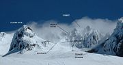
The most popular route, dubbed the south route, begins at Timberline Lodge and proceeds up Palmer glacier to Crater Rock, the large prominence at the head of the glacier. Climbers then proceed around Crater Rock and cross Coalman glacier on the Hogsback, a ridge spanning from Crater Rock to the approach to the summit. The Hogsback terminates at a bergschrund where Coalman glacier separates from the summit rock headwall, and then to the Pearly Gates, a gap in the summit rock formation. Once through the Pearly Gates, climbers proceed to the right onto the summit plateau and then to the summit proper.[28]
Technical ice axes, fall protection, and experience are now recommended in order to attempt the left chute variation or Pearly Gates ice chute. The Forest Service is recommending several other route options due to these changes in conditions (e.g. "Old Chute", West Crater Rim, etc).[29]
Climbing accidents
More than 130 people have died in climbing-related accidents since records have been kept on Mount Hood, the first in 1896.[30] Incidents in April 1986 and December 2006 attracted intense national and international media interest. Though avalanches are popularly considered a hazard, most climbing deaths are the result of falls and hypothermia.[31] Despite a quadrupling of forest visitors since 1990, fewer than 50 people require rescue per year.[32] Only 3.4 percent of search and rescue missions in 2006 were for mountain climbers.[33]
Hiking
The Timberline Trail, which circumnavigates the entire mountain, was built in the 1930s by the Civilian Conservation Corps. Typically, the 40.7-mile (65.5 km) hike is snow-free from late July until the autumn snows begin. A portion of the Pacific Crest Trail is coincident with the Timberline Trail on the west side of Mount Hood.[34]
Ship names

There have been two US Navy ammunition ships named for the mountain. USS Mount Hood (AE-11) was commissioned in July 1944 and was destroyed in November 1944 while at anchor in Manus Naval Base, Admiralty Islands. Her explosive cargo ignited resulting in 45 confirmed dead, 327 missing and 371 injured.[35] A second ammunition ship, AE-29, was commissioned in May 1971 and decommissioned in August 1999.
See also
- Cascade Volcanoes
- Barlow Road, pioneer road over the south flank built in 1846
- Mount Hood Corridor
- Mount Hood Railroad
- Mountain peaks of North America
- Mountain peaks of the United States
References
- ↑ 1.0 1.1 1.2 1.3 "Mount Hood Highest Point". NGS data sheet. U.S. National Geodetic Survey. http://www.ngs.noaa.gov/cgi-bin/ds_mark.prl?PidBox=RC2244. Retrieved on 2008-03-31
- ↑ "Mount Hood, Oregon". Peakbagger.com. Retrieved on 2008-03-31.
- ↑ 3.0 3.1 "Mount Hood–History and Hazards of Oregon's Most Recently Active Volcano". U.S. Geological Survey Fact Sheet 060-00. USGS and USFS (2005-06-13). Retrieved on 2007-01-16.
- ↑ "Glaciers of Oregon". Departments of Geology and Geography at Portland State University. Retrieved on 2007-02-24. quoting McNeil, Fred H. (1937). Wy'east the Mountain, A Chronicle of Mount Hood. Metropolitan Press. OCLC 191334118.
- ↑ "Mount Hood Glaciers and Glaciations". USGS Cascades Volcano Observatory. Retrieved on 2007-01-16.
- ↑ 6.0 6.1 6.2 6.3 6.4 Swanson,, D.A.; et.al. (1989). "Cenozoic Volcanism in the Cascade Range and Columbia Plateau, Southern Washington and Northernmost Oregon". AGU Field Trip Guidebook T106. USGS.
- ↑ Most likely to erupt based on history, see James S. Aber. "Volcanism of the Cascade Mountains". GO 326/ES 767. Emporia State University. Retrieved on 2007-07-11.
- ↑ 8.0 8.1 W.E. Scott, T.C. Pierson, S.P. Schilling, J.E. Costa, C.A. Gardner, J.W. Vallance, and J.J. Major. "Volcano Hazards in the Mount Hood Region, Oregon". USGS. Retrieved on 2008-11-13.
- ↑ "National Historic Landmarks Program—Timberline Lodge". National Historic Register. US National Parks Service (December 22, 1977). Retrieved on 2008-11-13.
- ↑ "Beat the Heat: Summer Skiing on Oregon's Mount Hood". FastTracks Online Ski Magazine (July 17, 2006). Retrieved on 2007-01-03.
- ↑ "USDA Forest Service Mount Hood Facts". US Forest Service (23 August 2005). Retrieved on 2007-06-22.
- ↑ 12.0 12.1 "Mount Hood Volcano, Oregon". USGS Cascades Volcano Observatory. Retrieved on 2007-01-16.
- ↑ "Hood - Monthly Reports". Global Volcanism Program. Smithsonian Institution. Retrieved on 2007-06-22.
- ↑ "Cascade Range Current Update for June 29, 2002". USGS (June 29, 2002). Retrieved on 2007-06-22.
- ↑ "Cascade Range Current Update". USGS. Retrieved on 2007-06-22.
- ↑ "Oregon Volcanoes - Mt. Hood Volcano". Deschutes & Ochoco National Forests - Crooked River National Grassland. United States Forest Service (2003-12-24). Retrieved on 2008-09-18.
- ↑ 17.0 17.1 17.2 17.3 17.4 17.5 17.6 17.7 Jack Grauer (July 1975). Mount Hood: A Complete History. self published. pp. 199, 291–292. ISBN 0-930584-01-5.
- ↑ "Mount Hood National Forest". Encyclopædia Britannica (2008). Retrieved on 2008-09-07.
- ↑ "Mount Hood Glaciers and Glaciations". USGS. Retrieved on 2007-08-14.
- ↑ "USGS Mount Hood North (OR) Topo". TopoQuest. Retrieved on 2008-05-16.
- ↑ 21.0 21.1 21.2 Carolyn L. Driedger and Paul M. Kennard (1986). "Ice Volumes on Cascade Volcanoes: Mount Rainier, Mount Hood, Three Sisters and Mount Shasta". Geological Survey Professional Paper 1365. USGS. Retrieved on 2007-02-26.
- ↑ "Northwest GeoData Clearinghouse". Portland State University. Retrieved on 2007-02-21.
- ↑ "Volcanoes in Historical and Popular Culture: Legends and Mythology". Retrieved on 2008-12-19.
- ↑ Ella E. Clark (1953). Indian Legends of the Pacific Northwest. University of California Press. ISBN 0520239261. OCLC 51779712.
- ↑ 25.0 25.1 Grauer, p. 9
- ↑ "Volcanoes of Lewis and Clark". USGS.
- ↑ Green, Aimee; Mark Larabee and Katy Muldoon (2007-02-19). "Everything goes right in Mount Hood search". The Oregonian. Archived from the original on 2007-12-23. Retrieved on 2008-12-19.
- ↑ "Climbing Mount Hood". United States Forest Service. Retrieved on 2007-02-02.
- ↑ "Mount Hood Climbing Report, May 17th". United States Forest Service. Retrieved on 2007-05-17.
- ↑ "Last Body Recovered From Mount Hood". CBS (May 31, 2002). Retrieved on 2007-05-25.
- ↑ "Mount Hood National Forest Technical Climbing". GORP.com. Retrieved on 2008-08-28.
- ↑ Nigel Jaquiss (October 13, 1999). "Without A Trace". Willamette Week. Retrieved on 2006-12-19.
- ↑ Kristi Keck (2007-02-20). "Weighing the risks of climbing on Mount Hood". CNN. Archived from the original on 2007-03-02. Retrieved on 2008-12-19.
- ↑ Ron C. Judd and Dan A. Nelson (1995). The Complete Guide Pacific Northwest Hiking. Foghorn Press. ISBN 0-935701-04-4. OCLC 32879305.
- ↑ "USS Mount Hood (AE-11), 1944-1944". Department of the Navy – Naval Historical Center. Retrieved on 2008-04-20.
External links
- "Hood". Global Volcanism Program. Smithsonian Institution. Retrieved on 2008-12-19.
- "Mount Hood". Geographic Names Information System. U.S. Geological Survey. Retrieved on 2008-08-26.</ref>
- "Mt. Hood History". mounthoodhistory.com. Retrieved on 2008-12-19.
|
|||||
|
||||||||||||||||
|
|||||||||||||||||
|
|||||