Montgomery County, New York
| Montgomery County, New York | |
| Map | |
 Location in the state of New York |
|
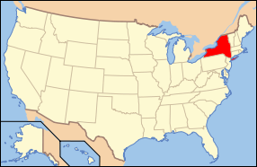
 New York's location in the U.S. |
|
| Statistics | |
| Founded | March 12, 1772 |
|---|---|
| Seat | Fonda |
| Area - Total - Land - Water |
410 sq mi (1,062 km²) 6 sq mi (16 km²), 1.34% |
| Population - (2000) - Density |
49,708 122/sq mi (47/km²) |
| Website: www.co.montgomery.ny.us | |
Montgomery County is a county located in the U.S. state of New York. It was named in honor of Richard Montgomery, an American Revolutionary War general killed in 1775 at the Battle of Quebec. The county seat is Fonda.
Contents |
History
For the history of Montgomery County prior to 1784 see Tryon County, New York
In 1784, following end of the American Revolutionary War, the name of Tryon County was changed to Montgomery County. This change was to honor the general, Richard Montgomery, who had captured several places in Canada and died attempting to capture the city of Quebec, replacing the name of the British governor.
In 1789, Ontario County was split off from Montgomery. The actual area split off from Montgomery County was much larger than the present county, also including the present Allegany, Cattaraugus, Chautauqua, Erie, Genesee, Livingston, Monroe, Niagara, Orleans, Steuben, Wyoming, Yates, and part of Schuyler and Wayne Counties.
In 1791, Herkimer, Otsego, and Tioga Counties were split off from Montgomery.
In 1802, portions of Clinton, Herkimer, and Montgomery Counties were combined to form St. Lawrence County.
In 1816, Hamilton County was split off from Montgomery.
In 1838, Fulton County was split off from Montgomery.
Geography
Montgomery County is located in the central part of the state, west of the city of Schenectady and northwest of Albany.
According to the U.S. Census Bureau, the county has a total area of 410 square miles (1,063 km²), of which, 405 square miles (1,048 km²) of it is land and 6 square miles (14 km²) of it (1.34%) is water.
Adjacent counties
- Fulton County, New York - north
- Saratoga County, New York - east
- Schenectady County, New York - east
- Schoharie County, New York - south
- Otsego County, New York - southwest
- Herkimer County, New York - west
The Erie Canal Runs through Montgomery County parallel to the NYS Thruway. The original canal ran through several towns and village during the height of the canal days. After the railroad was built the old canal was filled up and then moved along the whole length of the Mohawk River to keep up with competition. The NYS Thruway was then added along the same route and today the Erie Canal and its lock system is used primarily for recreational use among locals and tourists. At the time of its construction, Montgomery County was the only place in the nation where the canal was able to be built due to the break in the Appalacian Mountains called 'The Noses' also known as 'the gateway to the West'.
Demographics
As of the census[1] of 2000, there were 49,708 people, 20,038 households, and 13,104 families residing in the county. The population density was 123 people per square mile (47/km²). There were 22,522 housing units at an average density of 56 per square mile (21/km²). The racial makeup of the county was 94.87% White, 1.15% African American, 0.25% Native American, 0.53% Asian, 0.01% Pacific Islander, 1.92% from other races, and 1.27% from two or more races. Hispanic or Latino of any race were 6.91% of the population. 19.0% were of Italian, 15.9% German, 13.5% Polish, 9.1% Irish, 7.9% American and 6.4% English ancestry according to Census 2000. 89.8% spoke English, 6.3% Spanish and 1.5% Polish as their first language.
There were 20,038 households out of which 29.40% had children under the age of 18 living with them, 49.00% were married couples living together, 11.60% had a female householder with no husband present, and 34.60% were non-families. 29.50% of all households were made up of individuals and 14.90% had someone living alone who was 65 years of age or older. The average household size was 2.42 and the average family size was 2.98.
In the county the population was spread out with 24.50% under the age of 18, 7.20% from 18 to 24, 26.30% from 25 to 44, 22.90% from 45 to 64, and 19.20% who were 65 years of age or older. The median age was 40 years. For every 100 females there were 91.40 males. For every 100 females age 18 and over, there were 87.90 males.
The median income for a household in the county was $32,128, and the median income for a family was $40,688. Males had a median income of $30,818 versus $23,359 for females. The per capita income for the county was $17,005. About 9.00% of families and 12.00% of the population were below the poverty line, including 16.80% of those under age 18 and 10.00% of those age 65 or over.
Cities and towns
- Ames (village)
- Amsterdam (city)
- Amsterdam (town)
- Canajoharie (town)
- Canajoharie (village)
- Charleston (town)
- Florida (town)
- Fonda (village)
- Fort Johnson (village)
- Fort Plain (village)
- Fultonville (village)
- Glen (town)
- Hagaman (village)
- Minden (town)
- Mohawk (town)
- Nelliston (village)
- Palatine Bridge (village)
- Palatine (town)
- Root (town)
- St. Johnsville (town)
- St. Johnsville (village)
- Labels in parentheses are official designations.
See also
References
- ↑ "American FactFinder". United States Census Bureau. Retrieved on 2008-01-31.
External links
- Montgomery County, NY
- Montgomery County at the Open Directory Project
- Summary history of Montgomery County
|
||||||||||||||||||||
|