Mont Blanc
- See also: Mont Blanc Massif
| Monte Bianco — Mont Blanc | |
|---|---|
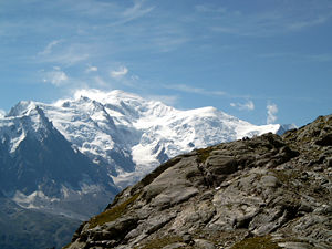 Mont Blanc and the Dôme du Goûter |
|
 Monte Bianco — Mont Blanc
|
|
| Elevation | 4,810 metres (15,781 ft) |
| Location | |
| Range | Graian Alps |
| Prominence | 4,695 m (15,404 ft) ranked 11th |
| Coordinates | |
| First ascent | 8 August 1786 by Jacques Balmat and Michel-Gabriel Paccard |
| Easiest route | Basic snow/ice climb |
| Listing | Country high point Ultra |
Mont Blanc (French for white mountain), or Monte Bianco (Italian 'White Mountain'), also known as "La Dame Blanche" (French, the white lady) is a mountain in the Alps. With its 4,810 m (15,781 ft) summit, it is the highest mountain in the Alps and Western Europe[1], and is ranked 11th in the world in topographic prominence.
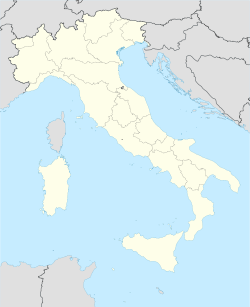
The mountain lies between the regions of Aosta Valley, Italy, and Haute-Savoie, France. The location of the summit is on the French-Italian border but Cartographers of France place it within its own boundaries on maps. It is claimed by Italian sources that at a convention between France and Kingdom of Sardinia, in Turin (1861), the border [2] was fixed on the highest point of Mont Blanc, the south east ridge to Monte Bianco di Courmayeur wholly within Italy, and that this was the last official definition of this border. Lately, at the end of his studies of many different maps and with auxiliary of Istituto Cartografico dell’Esercito, Antonio Napolitano, the Italian leader of a mixed commission, claimed exclusive Italian ownership of the summit.[3][4] The two most famous towns near Mont Blanc are Courmayeur, in Aosta Valley, Italy, and Chamonix, in Haute-Savoie, France — the site of the first Winter Olympics. From Chamonix a cable car ascends the mountain side.
Begun in 1957 and completed in 1965, the 11.6 km (7¼ mi) Mont Blanc Tunnel runs beneath the mountain between these two countries and is one of the major trans-Alpine transport routes.
The Mont Blanc Massif is popular for mountaineering, hiking, skiing and snowboarding.
Contents |
History

The first recorded ascent of Mont Blanc was on 8 August 1786 by Jacques Balmat and the doctor Michel Paccard. This climb, initiated by Horace-Bénédict de Saussure, who gave a reward for the successful ascent, traditionally marks the start of modern mountaineering. The first woman to reach the summit was Marie Paradis in 1808.
Now the summit is ascended by an average 20,000 mountaineer-tourists each year and could be considered an easy, yet long, ascent for someone who is well trained and used to the altitude. This impression is reinforced by the fact that from l'Aiguille du Midi (where the cable car stops), Mont Blanc seems quite close, being merely 1,000 m (3,300 ft) higher.
However, every year the Mont Blanc massif takes many victims, and in peak weekends (normally around August) the local rescue service flies an average of 12 missions, mostly directed towards people in trouble on one of the normal routes of the mountain. These are courses that require knowledge of high-altitude mountaineering, a guide (or at least a veteran mountaineer), and proper equipment. It is a long course that includes delicate passages and the hazard of rock slides. Also, at least one night at the refuge is required to get used to the altitude (the summit is almost 5 km (3.1 mi) above sea level); less could lead to altitude sickness and possible death.
Ownership of summit

Since the French Revolution this question has spurred many debates. Before this event, the whole mountain was in the Kingdom of Sardinia for several centuries.
The first treaty to define a border in the region is dated 15 May 1796. In this treaty the Sardinian king ceded the territories of Savoie and Nice to the French Republic, and in article 4 of this treaty it says: "The border between the Sardinian kingdom and the departments of the French Republic will be established on a line determined by the most advanced points on the Piedmont side, of the summits, peaks of mountains and other locations subsequently mentioned, as well as the intermediary peaks, knowing: starting from the point where the borders of Faucigny, the Duchy of Aoust and the Valais, to the extremity of the glaciers or the Monts-Maudits: first the peaks or plateaus of the Alps, to the rising edge of the Col-Mayor". This act is even more confusing, because it states that the border should be visible from the town of Chamonix and Courmayeur. The summit is not visible from Courmayeur, because part of the mountain lower down obscures it. Already inaccurate at the time, this treaty is no longer valid, because it was replaced by a later legal act.
This act was signed in Turin on 24 March 1860 by Napoleon III and Victor Emmanuel II of Savoy, and deals with the annexation of Savoie. A demarcation agreement, signed on 7 March 1861, defines the "new border".
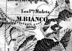
One of the prints from the Sarde Atlas,[2] made in 1823 and positions the border exactly on the summital edge of the mountain (and measures it to be 4,804 m (15,760 ft) high).
The convention of 7 March 1861 recognizes this, through an attached map, taking into consideration the limits of the massif, and drawing the border on the icecap of the Mont Blanc, and therefore makes it both French and Italian. Watershed analysis of modern topographic mapping not only places the main summit on the border, but also suggests that the border should follow a line northwards from the main summit towards Mont Maudit, leaving the south east ridge to Mont Blanc de Courmayeur wholly within Italy.
Despite the fact that the Franco-Italian border was redefined in both 1947 and 1963, the commission, made up of both Italians and French, tactfully ignored the Mont Blanc issue.
The Vallot cabin
The first real scientific investigations on the summit were conducted by the botanist-meteorologist Joseph Vallot at the end of the 19th century. He wanted to stay near the top of the summit, so he had to build his own permanent cabin.
The Janssen Observatory
In 1891, Pierre Janssen, a scientific academic, envisaged the construction of an observatory at the summit of Mont Blanc. Gustave Eiffel agreed to take on the project, provided he could find strong foundations. The Swiss surveyor Imfeld dug down 15 m (49 ft) but found nothing solid, so Eiffel gave up.
Despite this, the observatory was built in 1893. During the cold wave of January 1893 a temperature of −43 °C (−45.4 °F) was recorded on the Mount Blanc, being the lowest ever recorded there. Levers attached to the ice supported the observatory. This worked to some extent until 1906, when the building started leaning heavily. The movement of the levers corrected the lean slightly, but three years later (two years after Janssen’s death) a crevasse started opening under the observatory and it was abandoned. Eventually the building fell, and only the tower could be saved in extremis.
Air crashes
The mountain was the scene of two fatal Air India air crashes in 1950 [5] and 1966. Both planes were approaching Geneva airport and the pilots miscalculated their descent; 48 and 117 people, respectively, lost their lives. [6]
Elevation


The summit of Mont Blanc is a thick, perennial ice and snow dome whose thickness varies, so no exact and permanent summit elevation can be determined. But accurate measurements have been made. For a long time its official elevation was 4,807 m (15,770 ft). Then in 2002, the IGN and expert surveyors, with the aid of GPS technology, measured it to be 4,810.40 m (15,782 ft 2 in).
After the 2003 heatwave in Europe, a team of scientists re-measured the height on 6 and 7 September. The team was made up of the glaciologist Luc Moreau, two surveyors from the GPS Company, three people from the IGN, seven expert surveyors, four mountain guides from Chamonix and Saint-Gervais and four students from various institutes in France. This team noted that the elevation was 4,808.45 m (15,775 ft 9 in), and the peak was 75 centimetres (30 in) away from where it had been in 2002.
After these results were published, more than 500 points were measured, to assess the effects of climate change, and the fluctuations in the height of the mountain at different points. From then on the elevation of the mountain has been measured every two years.
The interpretation that the heatwave had caused this fluctuation is disputed, because the heatwave is known not to have significantly affected the glaciers above 4,000 m (13,000 ft). The height and position of the summit could have been moved by general glacial forces. At this elevation, the temperatures rarely rise above 0 °C (32 °F). During the summer of 2003, the temperature rose to 2 °C (36 °F), and even 3 °C (37 °F), but this would not have been enough for the ice, which stayed at −15 °C (5.0 °F), to melt.
The summit was measured again in 2005, and the results were published on 16 December 2005. The height was found to be 4,808.75 m (15,776 ft 9 in), 30 cm (12 in) more than the previous recorded height.
The actual rock summit is at 4,792 m (15,720 ft), and is 40 m (130 ft) away from the ice-covered summit.[7]
Climbing routes
There are a few classic climbing routes of Mont Blanc:
- The most popular route to climb Mont Blanc is The Voie des Cristalliers, also known as Voie Royale. Starting from Saint-Gervais-les-Bains the Tramway du Mont-Blanc (TMB) is taken to get to the Nid d'Aigle. The ascent then begins in the direction of the Tête Rousse cabin and then through the Goûter Corridor [1], considered dangerous because of frequent rock-falls, leading to Goûter cabin for night shelter. The next day the route leads to the Dôme du Goûter, the Vallot cabin and L'arrête des Bosses.
![[1]](http://commons.wikimedia.org/wiki/Image:Le-Grand-Couloir.jpg)
- La Voie des 3 Monts is also known as La Traversée. Starting from Chamonix, the Téléphérique de l'Aiguille du Midi is taken towards the Col du Midi. The Cosmiques cabin is used to spend the night. The next day the ascent continues through Mont Blanc du Tacul and Mont Maudit.
- The historic itinerary through the Grand Mulets, which is most frequently traversed in winter by skis or in summer to go down to Chamonix.
- The normal Italian itinerary is also known as La route des Aiguilles Grises. After crossing the Miage glacier, the night is spent at the Gonella cabin. The next day proceeds through the Col des Aiguilles Grises and then the Dôme du Goûter, concluding at L'arête des Bosses.
- The Miage — Bionnassay — Mont Blanc crossing is usually done in three days. The route begins from Contamines-Montjoie, with the night spent in the Conscrits cabin. The following day, the Dômes de Miages is crossed and the night spent at the Durier cabin. The third day proceeds through l'Aiguille de Bionnassay and then the Dôme du Goûter.
From the summit of Mont Blanc on a clear day, the Jura, the Vosges, the Black Forest and the Massif Central mountain ranges can be seen, as well as the principal summits of the Alps.
Exploits
- Mont Blanc was first climbed in 1786, see Exploration of the High Alps.
- The fourth ascent in 1787, by Englishman Mark Beaufoy, with at least six guides and a servant.
- In 1886, future U.S. President Theodore Roosevelt led an expedition to the peak.
- In 1890, Giovenni Bonin, Luigi Grasselli and Fr. Achille Ratti (later Pope Pius XI) discovered the normal Italian route (West Face Direct) on descent.
- In 1960, the airplane pilot Henri Giraud landed on the summit, which is only 30 m (98 ft) long.
- On the 8th August, 1986, Dennis Morrod UK, reached the summit on the Bi-Centenary of the first ascent of Mont Blanc (8th August, 1786) having walked, climbed from Les Houches. To commemorate the Bi-Centenary year further, made six more ascents climbing from Les Houches.
- In 1990, the Swiss Pierre-André Gobet, leaving from Chamonix, completed the ascent and descent in 5 hours, 10 minutes and 14 seconds.
- On 30 May 2003, Stéphane Brosse and Pierre Gignoux tried to beat the record by ski-walking. They went up in 4 hours and 7 minutes, and came back down in 1 hour and 8 minutes. In total they did the ascent and descent in 5 hours and 15 minutes.
- On 13 August 2003 seven French paraglider pilots landed on the summit. They reached a peak altitude of 5,200 m (17,000 ft), thanks to the hot weather conditions, which provided strong hot air currents. Five had left from Planpraz, one from Rochebrune at Megève and the last one from Samoëns.
- On 8 June 2007, Danish artist Marco Evaristti draped the peak of Mont Blanc with red fabric, along with a 20-foot (6.1 m) pole with a flag reading "Pink State". He was arrested and detained on 6 June for attempting to paint the peak red. His aim is to raise awareness of environmental degradation.[8]
- On 13 September 2007, a group of 20 people set up a hot tub at the summit.[9][10]
Cultural works
Cinema and television
- La Terre, son visage, is a documentary by Jean-Luc Prévost and published by Édition Société national de télévision française, released in 1984. It is part of the Haroun Tazieff raconte sa terre, vol. 1 series. In it he talks about the west-east crossing of Mont Blanc.
- The film Malabar Princess.
- The television-film Premier de cordée.
- Stürme über dem Mont Blanc (Storm Over Mont Blanc, 1930) with Leni Riefenstahl and directed by Arnold Fanck.
In literature
- Premier de cordée by Roger Frison-Roche
- Hugo et le Mont Blanc by Colette Cosnie – Édition Guérin
- Frankenstein by Mary Shelley
- Mont Blanc by Percy Shelley
- Point Blanc by Anthony Horowitz
- The Prelude Book VI by William Wordsworth
- Kordian by Juliusz Słowacki
Protection of Mont Blanc
The Mont Blanc massif is being put forward as a potential World Heritage Site because of its uniqueness and its cultural importance, considered the birthplace and symbol of modern mountaineering. However not everyone shares this goal and it would require the three governments of Italy, France and Switzerland to make a request to UNESCO for it to be listed.
Mont Blanc is one of the most visited tourist destinations in the world, and for this reason, it is threatened. Pro-Mont Blanc (an international collective of associations for the protection of Mont Blanc) published in 2002 the book Le versant noir du mont Blanc (The black hillside of Mont Blanc), which exposes current and future problems in conserving the site. [2]
In 2007, Europe's highest outhouses (two) were transported by helicopter and installed at an elevation of 4,260 metres (14,000 ft). The dunny-cans are emptied by helicopter. The facilities will service 30,000 skiers annually, and will help prevent the deposit of urine and feces that spread down the mountain face with the spring thaw.[11]
Bibliography
- Rey, Guido, The Matterhorn (translated J. E. C. Eaton), London, 1907[12]
See also
- Mont Blanc Tunnel
- Mont Blanc Tramway
- Mont Blanc Massif
- Haute Route
- Tour du Mont Blanc
- Mons Blanc
- List of mountains
- Exploration of the High Alps
References
- ↑ The Caucasus mountains, which include higher peaks than Mont Blanc, are included on political maps of Europe, although the case can be made that they are geographically and culturally more Asian than European. Excluding the Caucasus, Mont Blanc is the highest summit in Europe.
- ↑ 2.0 2.1 Image:1823 Mont Blanc 1.jpg
- ↑ Achievement of the working group in which the Italian property of the European peack is pointed out.
- ↑ Repubblica, 31 ganuary 2005 On the false historical line of the French topographic map.
- ↑ The glacier des Bossons : plane crashes:
- ↑ BBC ON THIS DAY 24 January 1966: 117 die in Air India tragedy
- ↑ Vincent, Christian (2004-08-02). "The rock summit of the Mont Blanc, 40 m west of the ice summit". Centre National de la Recherche Scientifique. Retrieved on 2008-08-08.
- ↑ Danish Artist Drapes Mont Blanc in Red, June 8, 2007
- ↑ KAIRN > Montagne / Escalade / Nature / Outdoor
- ↑ Jaccuzzi (sic) on Mont-Blanc summit
- ↑ Ananova.com
- ↑ Rey's Il Monte Cervino was first published in Italian and appeared in English in 1907, in a translation by J. E. C. Eaton; a revised edition, with two further chapters by R. L. G. Irving, was published in Oxford by Basil Blackwell, 1946, and reprinted in 1949
Photo gallery
External links
- Mont Blanc on TierraWiki.org: Trails, Trip Reports, and GPS Routes
- (Italian) Reasoning about the border between France and Italy by Umberto PellazzaPDF (12.5 KiB)
- Official paper of the French surveying boardPDF
- Mont Blanc on Peakware
- Info on Climbing Mont Blanc, route guides gallery.
- Mont Blanc on Summitpost
- Mont Blanc on dieAlpen.at Online encyclopedia of the Alps
- Mont Blanc Massif Photos of the Mont Blanc massif including GPS coordinates of the photo locations
- Mont Blanc from space
- Photos, Pictures and Videos of Ascents of Mont Blanc Post and view stories here
- Pictures of Mont Blanc massif and surroundings
- Descent into the Ice Companion web site to the PBS NOVA program which follows a glaciologist and a climber into the glacier caves of Mont Blanc
- Mont Blanc from Pointe de Drône
- proMONT-BLANC English Site
- Why you might not want to climb Mont Blanc The mountaineering page on this site has an informative PDF document from the local guide bureau
- Funivie Monte Bianco
- Chamonix-Mont-Blanc Map
- Tour of Mont Blanc
- Live view of Mont Blanc and La Source ski resort
- Mont Blanc video. Climbing on French normal route
|
|||||||||||||||||||||||||||||