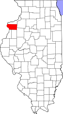
Mercer County, Illinois
| Mercer County, Illinois | |
| Map | |
 Location in the state of Illinois |
|
 Illinois's location in the U.S. |
|
| Statistics | |
| Founded | January 13, 1825 |
|---|---|
| Seat | Aledo |
| Area - Total - Land - Water |
569 sq mi (1,474 km²) 561 sq mi (1,453 km²) 8 sq mi (21 km²), 1.38% |
| Population - (2000) - Density |
16,957 31/sq mi (12/km²) |
| Website: www.mercercountyil.org | |
Mercer County is a county located in the U.S. state of Illinois. As of 2000, the population was 16,957. Its county seat is Aledo.[1] It is one of the four counties that make up the Davenport-Moline-Rock Island Metropolitan Statistical Area.[2]
Contents |
History
Mercer County is named for Hugh Mercer (1726-1777), a physician and general during the American Revolution who died from wounds suffered at the Battle of Princeton.
In May 1812, Congress passed an act which set aside lands in Arkansas, Michigan, and Illinois as payment to volunteer soldiers in the War of 1812. Mercer County was part of this "Military Tract."
Seven years after Illinois became a state, Mercer County was founded. It was formed from unorganized territory near Pike County on January 13, 1825.
Geography
According to the U.S. Census Bureau, the county has a total area of 569 square miles (1,473 km²), of which, 561 square miles (1,453 km²) of it is land and 8 square miles (20 km²) of it (1.38%) is water.
Townships
Abington, Duncan, Eliza, Greene, Keithsburg, Mercer, Millersburg, New Boston, North Henderson, Ohio Grove, Perryton, Preemption, Richland Grove, Rivoli, Suez
Adjacent counties
- Rock Island County - north
- Henry County - east
- Knox County - southeast
- Henderson County - south
- Warren County - south
- Des Moines County, Iowa - southwest
- Louisa County, Iowa - west
Demographics
| Historical populations | |||
|---|---|---|---|
| Census | Pop. | %± | |
| 1900 | 20,945 |
|
|
| 1910 | 19,723 | −5.8% | |
| 1920 | 18,800 | −4.7% | |
| 1930 | 16,641 | −11.5% | |
| 1940 | 17,701 | 6.4% | |
| 1950 | 17,374 | −1.8% | |
| 1960 | 17,149 | −1.3% | |
| 1970 | 17,294 | 0.8% | |
| 1980 | 19,286 | 11.5% | |
| 1990 | 17,290 | −10.3% | |
| 2000 | 16,957 | −1.9% | |
| IL Counties 1900-1990 | |||
As of the census[3] of 2000, there were 16,957 people, 6,624 households, and 4,915 families residing in the county. The population density was 30 people per square mile (12/km²). There were 7,109 housing units at an average density of 13 per square mile (5/km²). The racial makeup of the county was 98.37% White, 0.29% Black or African American, 0.12% Native American, 0.17% Asian, 0.01% Pacific Islander, 0.35% from other races, and 0.68% from two or more races. 1.27% of the population were Hispanic or Latino of any race. 25.4% were of German, 14.1% American, 13.0% Swedish, 12.3% English and 11.3% Irish ancestry according to Census 2000.
There were 6,624 households out of which 32.10% had children under the age of 18 living with them, 63.5% were married couples living together, 7.2% had a female householder with no husband present, and 25.8% were non-families. 22.8% of all households were made up of individuals and 11.6% had someone living alone who was 65 years of age or older. The average household size was 2.53 and the average family size was 2.96.
In the county the population was spread out with 24.80% under the age of 18, 7.3% from 18 to 24, 26.6% from 25 to 44, 25.4% from 45 to 64, and 15.90% who were 65 years of age or older. The median age was 40 years. For every 100 females there were 96.90 males. For every 100 females age 18 and over, there were 94.20 males.
The median income for a household in the county was $40,893, and the median income for a family was $47,192. Males had a median income of $35,138 versus $22,227 for females. The per capita income for the county was $18,645. 7.8% of the population and 5.8% of families were below the poverty line. 10% of those under the age of 18 and 8.4% of those 65 and older were living below the poverty line.
Cities and towns
- Aledo
- Alexis
- Boden
- Burgess
- Cable
- Eliza
- Gilchrist
- Hamlet
- Joy
- Keithsburg
- Mannon
- Marston
- Matherville
- Millersburg
- New Boston
- New Windsor
- North Henderson
- Norwood
- Petersville
- Preemption
- Reynolds
- Seaton
- Shale City
- Sherrard
- Sugar Grove
- Swedona
- Viola
- Wanlock
- Windsor
Townships
Mercer County is divided into fifteen townships:
|
|
|
References
- ↑ "Find a County". National Association of Counties. Retrieved on 2008-01-31.
- ↑ United States Office of Management and Budget. "Update of Statistical Area Definitions and Guidance on Their Uses" (PDF) 5, 36.. Retrieved on 2006-07-21.
- ↑ "American FactFinder". United States Census Bureau. Retrieved on 2008-01-31.
External links
|
|||||||||||||||||||||||
|
|||||||||||||||||||||||
|