Massachusetts Bay Transportation Authority
| Massachusetts Bay Transportation Authority (MBTA) | |
 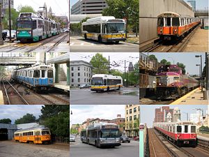 The Massachusetts Bay Transportation Authority provides services in five different modes (boat not pictured) around Greater Boston. |
|
| Info | |
|---|---|
| Locale | Greater Boston |
| Transit type | Commuter rail, rapid transit, light rail, bus, BRT, trolleybus, ferryboat |
| Number of lines | 12 (commuter rail) 4 (rapid transit) 5 (light rail) 4 (trolleybus) 4 (ferryboat) 183 (bus)[1] |
| Number of stations | 123 (commuter rail) 51 (rapid transit)[2] 74 (light rail)[3][4] 22 (BRT)[5] |
| Daily ridership | 1.1 million (weekday, all modes)[1] |
| Operation | |
| Began operation | 1897 (light rail) 1901 (rapid transit) 1964 (MBTA) |
| Operator(s) | MBTA (most bus, subway, BRT, trolleybus, light rail) ---- MBCR (commuter rail) ---- Harbor Express/Boston Harbor Cruises (Boat) ---- various contractors (700-series bus routes) |
| Technical | |
| System length | 1,193 mi (1,920 km) (total) 38 mi (61 km) (rapid transit) 26 mi (42 km) (light rail) 8 mi (13 km) (BRT) 751 mi (1,209 km) (bus and trackless trolley) 368 mi (592 km) (commuter rail)[6] |
The Massachusetts Bay Transportation Authority (MBTA) is "a body politic and corporate, and a political subdivision" of the Commonwealth of Massachusetts [2] formed in 1964 to finance and operate most bus, subway, commuter rail and ferry systems in the greater Boston, Massachusetts, area. It replaced the Metropolitan Transit Authority (MTA), immortalized by the Kingston Trio in the popular folk-protest lament "M.T.A.". Locals call it simply "The T", after its logo, the letter T in a circle, adopted in the 1960s. In 2006, the system averaged 1.1 million passenger trips each weekday,[1] of which the subway averaged 598,200,[7] making it the fourth busiest subway system in the United States. The Green Line and Ashmont–Mattapan High Speed Line of the T comprise the busiest light-rail system in the U.S, with a weekday ridership of 255,100. The MBTA also operates its own independent law enforcement agency, the Massachusetts Bay Transportation Authority Police. In 2006, 31.60% of workers in the city proper commuted by public transport[8]
Contents |
Subway

The subway system has three rapid transit lines - the Red, Orange and Blue Lines - and two light rail lines - the Green Line and the Ashmont-Mattapan High Speed Line (designated as part of the Red Line). All four colored lines meet downtown at a square configuration, and the Orange and Green Lines (which run parallel) meet directly at two stations. The Red Line has two branches in the south - Ashmont and Braintree, named after their terminal stations - and the Green Line has four branches in the west - "B" (Boston College), "C" (Cleveland Circle), "D" (Riverside) and "E" (Heath Street). The "A" Branch formerly went to Watertown, filling in the north-to-south letter assignment pattern, and the "E" Branch formerly continued beyond Heath Street to Arborway. The colors were assigned on August 26, 1965 in conjunction with design standards developed by Cambridge Seven Associates [9], and have served as the primary identifier for the lines since the 1964 reorganization of the MTA into the MBTA.
In FY2005, there were on average 628,400 weekday boardings on the rapid transit and light rail lines (including the Silver Line Bus Rapid Transit), or 55.0% of the MBTA system.[10]

The Orange Line is so named because it used to run down Orange Street (now lower Washington Street); the Green Line because it runs adjacent to parts of the Emerald Necklace; the Blue Line because it runs under Boston Harbor; and the Red Line because its northernmost station used to be at Harvard University, whose school color is crimson, in Cambridge, Massachusetts.[11]
The three rapid transit lines are incompatible: trains of one line would have to be modified to run on another. Orange and Blue Line trains are nearly identical, but Blue Line trains have pantographs for use north of Boston Harbor. However, some of the new Blue Line cars from Siemens Transportation are being tested on the Orange Line after-hours. There are no direct track connections between lines, except between the Red Line and Ashmont-Mattapan High Speed Line, but all except the Blue Line have unused connections to the national rail network, which have been used for deliveries.[12]
A segment of Green Line tunnel from Park Street opened in 1897, making it the first subway in the United States. The downtown portions of what are now the Green, Orange, Blue, and Red lines were all in service by 1912. Additions to the rapid transit network occurred in most decades of the 1900s, and continue in the 2000s with the addition of Silver Line bus rapid transit and planned Green Line expansion. (See History and Future plans sections.)
Commuter rail


The MBTA Commuter Rail system is a Regional rail network that shares its tracks with freight trains. In 2007 there are 12 lines, three of which have branches, and another branch provides access to Gillette Stadium for events. Eight of the lines converge at South Station, with four of these passing through Back Bay station. The other four converge at North Station. Amtrak uses two of the south-side lines and one of the north-side lines for long-distance intercity service
There is no passenger connection between the two sides, although there have been proposals to fix this with the North-South Rail Link. The opportunity for such a connection, in association with the burying of the Central Artery in the Big Dig was passed over. Passengers must take the Orange Line between Back Bay and North Station, the Red and Orange or Red and Green Lines between South and North Stations, or take a bus or taxicab.
A south side commuter rail line, the Greenbush Line, recently completed construction and testing and opened for commuting on Wednesday, October 31, 2007[3]; a south-side branch to Fall River and New Bedford is in the planning stages. Trackage exists to extend the Middleborough/Lakeville Line to restore passenger service to Cape Cod, formerly part of the Old Colony Railroad lines. The Commuter Rail system has used the color purple on train cars and system maps since October 8, 1974, and consequently it is sometimes called the "Purple Line."[4]
Each Commuter Rail line is divided into up to 9 fare zones (previously 10 on some lines), numbered 1A, and 1 through 8. Riders are charged based on the number of zones they travel through. Tickets can be purchased on the train or at designated ticket vendor locations near major stations. If a local vendor is available, riders must purchase a ticket before boarding to avoid a surcharge. Fares range from $1.70 to $7.75, with multi-ride and monthly passes available.
In FY2005, there were on average 135,900 weekday boardings, which was 11.9% of the MBTA system as a whole.[10]
Buses


The MBTA bus system is the nation's sixth largest by ridership and comprises over 150 routes across the Greater Boston area. The area served by the MBTA's bus operations corresponds to that served by the subway, but is significantly smaller than that served by MBTA's commuter rail operation. Seven other regional transit authorities also provide bus services within that larger area, these being Brockton Area Transit Authority, Cape Ann Transportation Authority, Greater Attleboro Taunton Regional Transit Authority, Lowell Regional Transit Authority, Merrimack Valley Regional Transit Authority, Montachusett Regional Transit Authority, and Worcester Regional Transit Authority. All of these authorities have their own fare structures and subcontract operation to private bus companies, but in many cases their buses serve as feeders to the MBTA commuter rail.[13]
Within MBTA's bus service area, transfers from the subway are free if using a CharlieCard (for local buses); transfers to the subway require paying the difference between bus and the higher subway fare (for local buses; if not using a CharlieCard, full subway fare must be paid in addition to full bus fare). Bus-to-bus transfers (for local buses) are free unless paying cash. Many of the outlying routes run express along major highways to downtown. The buses are colored yellow on maps and in station decor.
The Silver Line is the MBTA's first service designated as bus rapid transit, even though it lacks many of the characteristics of bus rapid transit. The first segment, replacing the 49 bus, which in turn replaced the Washington Street Elevated section of the Orange Line, began operations in 2002, with free transfers to the subways downtown until January 1 2007, when the fare system was revised. The "Washington Street" segment runs along various downtown streets, and mostly in dedicated bus lanes on Washington Street itself. It is categorized as a "bus" service for fare purposes.[14]
The "Waterfront" section opened at the end of 2004, and connects South Station to South Boston, partly via a tunnel and partly on the surface. These buses run dual-mode, trackless trolley in the tunnel and diesel bus outside. Service to Logan Airport began in June 2005. The Waterfront segment is classified as a "subway" for fare purposes.[14]
A third, fully tunneled segment is proposed to connect the two lines, which are currently not continuous. "Phase 3" is controversial due to its high cost and the fact that many do not consider Phase I to be adequate replacement service for the old Elevated.
Current plans include more bus rapid transit routes, including the Urban Ring, intended to expand upon existing Crosstown Buses.
The MBTA contracts with private bus companies to provide subsidized service on certain routes, outside of the usual fare structure. These are known collectively as the HI-RIDE Commuter Bus service, and are not numbered or mapped in the same way as integral bus services.[15]
Four routes to Harvard still run as trackless trolleys; there was once a much larger trackless trolley system.
In FY2005, there were on average 363,500 weekday boardings of MBTA-operated buses and trackless trolleys (not including the Silver Line), or 31.8% of the MBTA system. Another 4,400 boardings (0.38%) occurred on subsidized bus routes operated by private carriers. [10]
Ferries

The MBTA boat system comprises several ferry routes on Boston Harbor. One of these is an inner harbor service, linking the downtown waterfront with Boston Navy Yard in Charlestown. The other routes are commuter routes, linking downtown to Hingham, Hull and Quincy. Some commuter services operate via Logan International Airport.
All boat services are operated by private sector companies under contract to the MBTA. In FY2005, the MBTA boat system carried 4,650 passengers (0.41% of total MBTA passengers) per weekday.[10]
Paratransit
The MBTA contracts out operation of The RIDE, an on-demand pickup and dropoff service for people with mobility challenges. Paratransit services carry 5,400 passengers on a typical weekday, or 0.47% of the MBTA system.[10]
Fare collection
- See also: CharlieCard
Beginning January 1 2007, rapid transit trips (including rides on the Green Line) cost $1.70 for CharlieCard holders, $2.00 for CharlieTicket or cash payers. Bus and trackless trolley fares are $1.25 for CharlieCard holders, $1.50 for others. Persons using CharlieCards can transfer free from a subway to a bus, and from a bus to a subway for the $0.45 difference in price. CharlieTicket holders can transfer free between buses, but not from a subway to a bus. Cash payers get no free transfers.
The MBTA began collecting fares for outbound trips originating on the surface part of the Green Line on January 1, 2007. The 2007 fare increase also eliminated exit fares at certain Red Line stops and ended higher fares at inbound stops on the outer part of the Green Line "D" Branch.
Monthly passes have been in use since the late 1980s. The MBTA also sells one- and seven-day passes intended for visitors.
Parking
The MBTA operates park and ride facilities at many outlying stations, with a total capacity of almost 46,000 automobiles. The number of spaces at stations with parking varies from a few dozen to over 2,500. The larger lots and garages are usually near a major highway exit. Lots often fill up during the morning rush hour. There are some 22,000 spaces on the southern portion of the commuter rail system, 9,400 on the northern portion and 14,600 at subway stations. The parking fee for a day were raised by $2 on November 15, 2008 to $7.00 at subway parking garages, $5.00 to $6.00 at subway surface lots, $4.00 at commuter rail surface lots, and $3.00 at commuter ferry lots. Most stations also have parking racks for bicycles.
From time to time the MBTA has made various agreements with companies that contribute to commuting options. One company the MBTA selected was Zipcar; the MBTA currently provides Zipcar with a limited number of parking spaces at various subway stations throughout the system.[5]
Security
The MBTA has its own police department which actively patrols all areas and vehicles used by the MBTA. MBTA Police conduct routine vehicle patrol, routine foot patrol, and specialized patrol with K-9 dogs and other specialized methods of explosive and narcotics detection.
History


Mass transit in Boston was provided by private companies, often granted charters by the state legislature to create limited monopolies and grant powers of eminent domain to establish a right-of-way, until the creation of the MTA in 1947. Development of mass transportation followed both existing economic and population patterns, and helped shape those patterns.
Shortly after the steam locomotive became practical for mass transportation, the private Boston and Lowell Railroad was chartered in 1830, connecting Boston to Lowell a major northerly mill town via one of the oldest railroads in North America. This marked the beginning of the development of intercity railroads, which would evolve into the MBTA Commuter Rail system and the Green Line "D" Branch.
In the mid-nineteenth century, a profusion of streetcar lines appeared in the Boston under chartered companies. Later, many of these companies consolidated and animal-drawn vehicles were converted to electric propulsion.
Streetcar congestion in downtown Boston created the need for subways and elevated rail, the former established in 1897 and the latter in 1901, resulting in the Tremont Street Subway, the first subway in the United States. These grade-separated railways both added additional transportation capacity and avoided delays caused by intersections with cross streets.[16] The first elevated railway and the first rapid transit line in Boston came three years before the first underground line of the New York City Subway, but long after the first elevated railway in New York.

Various extensions and branches were built to the subway in both directions, bypassing more surface tracks. As more elevated lines were built, more and more streetcar lines were cut back for faster downtown service.
The Boston Elevated Railway started replacing rail vehicles with buses in 1922. In 1936, it started replacing some rail vehicles with trackless trolleys. The last Middlesex and Boston Street Railway streetcar ran in 1930. By the beginning of 1953, the only remaining streetcar lines fed two tunnels - the main Tremont Street Subway network downtown and the short tunnel (now the Harvard Bus Tunnel) in Harvard Square.
The old elevated railways proved to be an eyesore and required several sharp curves in Boston's twisty streets. The Atlantic Avenue Elevated was closed in 1938 amidst sliding ridership and demolished in 1942. As rail passenger service became increasingly unprofitable, largely due to the increasingly popular automobile, government takeover became necessary to prevent abandonment. The MTA purchased[17] and took over subway, elevated, streetcar, and bus operations from the Boston Elevated Railway in 1947.
In the 1950s, the MTA ran new subway extensions while the last two streetcar lines running into the Pleasant Street Portal of the Tremont Street Subway were substituted with buses in 1953 and 1962.
On August 3, 1964, the MBTA succeeded the MTA, with an enlarged service area. The original MTA district of 14 cities and towns was expanded to 78 cities and towns. The MBTA was formed partly to subsidize existing commuter rail operations. As this happened, the MBTA acquired the lines in stages from 1973 through 1976 amidst large cutbacks in service and coverage area. Since then, many of these lines have seen service return.
The MBTA assigned colors to its four rapid transit lines in 1965, and lettered the branches of the Green Line from north to south. However, shortages of streetcars, among other factors, caused bus substitution of rail service on two branches of the Green Line. The "A" Branch was replaced in its entirety in 1969. The portion of the "E" Branch from Heath Street to Arborway was replaced by buses in 1985.
The MBTA purchased bus routes in the outer suburbs to the north and south from the Eastern Massachusetts Street Railway in 1968. As with the commuter rail system, many of the outlying routes were dropped soon before or after the takeover due to low ridership and high operating costs.
In the 1970s, the MBTA received a boost from the Boston Transportation Planning Review areawide re-evaluation of the role of transit relative to highways. Producing a moratorium on highway construction inside Route 128, numerous transit lines were planned for expansion by the Voorhees-Skidmore, Owings and Merrill-ESL consulting team. The removal of elevated lines continued and the closure of the Washington Street Elevated brought the end of rapid transit service to the Roxbury neighborhood. Between 1971 and 1985, the Red Line was extended both north and south, providing not only additional subway system coverage, but also major parking structures at several of the terminal and intermediate stations.
In the 21st century
By 1999, the district was expanded further to 175 cities and towns, adding most that were served by or adjacent to commuter rail lines (including Maynard), though the MBTA did not assume responsibility for local service in those communities.

A turning point in funding happened in 2000. Prior to July 1, 2000, the MBTA was reimbursed by the Commonwealth of Massachusetts for all costs above revenue collected (net cost of service). Beginning on that date, the T was granted a dedicated revenue stream consisting of amounts assessed on served cities and towns, along with a dedicated 20% portion of the 5% state sales tax. The MBTA now must live within this "forward funding" budget.
The Commonwealth assigned to the MBTA responsibility for increasing public transit to compensate for increased automobile pollution from the Big Dig (see "Big Dig remediation projects" below). The T submerged a nearby portion of the Green Line and rebuilt Haymarket and North Stations during Big Dig construction, however these projects have strained the MBTA's limited resources since the Big Dig project did not include funding for these improvements. Since 1988, the MBTA has been the fastest expanding transit system in the country, even as Greater Boston has been the slowest growing metropolitan area.[18] When, in 2000, the MBTA's budget became limited, the agency began to run into debt from scheduled projects and obligatory Big Dig remediation work, which have now given the MBTA the highest debt of any transit authority in the country. In an effort to compensate, rates underwent an appreciable hike on January 1, 2007. Increasingly, local advocacy groups are calling on the state to assume $2.9 billion of the authority's now approximate debt of $9 billion, the interest on which severely limits funds available for required projects.[19]
With the 2004 replacement of the Causeway Street Elevated with a subway connection, the only remaining elevated railways are a short portion of the Red Line at Charles/MGH, the stretch of Red Line between Andrews Station (once the train exits the tunnel beyond Andrews Station going southbound) and proceeding southbound to either Ashmont Station on the Ashmont line or Braintree Station on the Braintree line, and a short portion of the Green Line between Science Park and Lechmere.
In the mid-2000s, the MBTA cut trips from published train and bus schedules without informing passengers, referred to as “hidden service cuts” by the MBTA general manager. In 2008, he admitted that MBTA lied to its customers.[6]
On October 31, 2007 the MBTA reestablished commuter rail service to the Greenbush section of Scituate, the third branch of the Old Colony service.[7]
On May 28, 2008, a westbound trolley on the Green Line "D" Branch slammed into a stopped train between the Waban and Woodland stations shortly after 6 p.m. At least seven people were injured and the operator of the moving train, identified as Terrese Edmonds, 24, was killed.[20]
Capital improvements
Capital planning process
The Boston Metropolitan Planning Organization is responsible for overall regional surface transportation planning. As required by federal law for projects to be eligible for federal funding (except earmarks), the MPO maintains a fiscally constrained 20+ year Regional Transportation Plan for surface transportation expansion, the current edition of which is called Journey to 2030. The required 4-year MPO plan is called the Transportation Improvement Plan.
The MBTA maintains its own 25-year capital planning document, called the Program for Mass Transportation, which is fiscally unconstrained. The agency's 4-year plan is called the Capital Improvement Plan; it is the primary mechanism by which money is actually allocated to capital projects. Major capital spending projects must be approved by the MBTA Board, and except for unexpected needs, are usually included in the CIP.
In addition to federal funds programmed through the Boston MPO, and MBTA capital funds derived from fares, sales tax, municipal assessments, and other minor internal sources, the T receives funding from the Commonwealth of Massachusetts for certain projects. The state may fund items in the State Implementation Plan (SIP) - such as the Big Dig mitigation projects - which is the plan required under the Clean Air Act to reduce air pollution. (As of 2007, all of Massachusetts is designated as a clean air "non-attainment" zone.)
In 2005, the administration of then-governor Mitt Romney announced a long range transportation plan that emphasized repair and maintenance over expansion.
Due to the financial constraints on the MBTA budget, the Executive Office of Transportation (controlled by the state governor and headed by the Massachusetts Secretary of Transportation) has agreed to plan and fund (through the state legislature) all expansion projects beyond the Silver Line Phase 3 project (which will be funded from MBTA capital budget and the federal New Starts program, if approved). The T will continue to be financially responsible for maintenance and enhancement of existing segments.
Projects underway
- Several stations on the Blue Line are being rebuilt to accommodate six-car trains and be handicap-accessible. As of February 2008, the first new Blue Line train-set was put into service. The entire Blue Line fleet will be replaced with new trains by the end of summer 2009.
- The Kenmore Square, Copley Square, and Arlington stations on the Green Line are being rebuilt for reasons of accessibility and aesthetics.
- A new station at T. F. Green Airport in Warwick, Rhode Island, 13 miles south of Providence that will allow expansion of MBTA commuter rail to that airport and Wickford Junction (Funded in the 2005 federal highway bill; work is expected to be completed in 2009). Amtrak could use the station as well.
- Rail renovation on the Green Line "D" Branch took place in the summer of 2007. The MBTA originally planned using new, low-floor cars on the line early in 2008, but as of late 2008 this has not become a reality.
- Several commuter rail bridges and track sections are being replaced.
- From June 2006 through December 22, 2007, the Mattapan-Ashmont trolley line was closed for renovation. When it reopened, all stations had been upgraded so that they are now ADA accessible and the 60+ year old streetcars had been overhauled. The huge inter-modal station at Ashmont is still under construction until 2009. Work is also continuing at the Shawmut and Fields Corner Red Line stations.
Big Dig remediation/SIP projects
After a lawsuit by the Conservation Law Foundation, Massachusetts agreed in 1990 to build several transit projects as remediation for the environmental impacts of the Big Dig, mostly increased air pollution due to automobile traffic.
The projects which have been completed include:
- Adding 20,000 new parking spaces
- Restoration of Old Colony Commuter Rail Service (Middleborough, Plymouth and Greenbush Lines)
- Restoration of Commuter Rail Service to Worcester
- Restoration of Commuter Rail Service to Newburyport
- Completion of the Silver Line Phases I and II
- Improved passenger waiting area at North Station
Remediation projects which are proceeding include:
- Extending the Green Line north beyond Lechmere, partially along commuter rail rights of way, to Tufts University and possibly to Union Square, Somerville. The governor's office has applied for a $300 million federal grant and aims to have the line in service in 2014. Money has already been transferred to the MBTA for the design of additional Green Line cars to serve this extension. The project was spurred along when the cities of Medford and Somerville had threatened to sue the Commonwealth of Massachusetts in 2005, claiming the state had not mitigated the increased air pollution caused by Big Dig traffic routed through these communities.
- Extending the Blue Line to Charles/MGH to connect with the Red Line. Money has been committed to the design of this extension, but none has been allocated to actually build it. Owners of historic buildings near Charles Street have expressed concerns that the excavation required might damage their foundations. The nearby medical facilities have sued for the connector, saying they based their expansion plans on previous promises, and that it is essential to connect the major medical facilities with the North Shore rapid transit line.
One of the original projects was the restoration of Green Line "E" Branch streetcar service to The Arborway and Centre Street in Jamaica Plain, which was "temporarily" suspended in 1985. Some Jamaica Plain residents and merchants object to the restoration of streetcar service, on the grounds that it would create traffic snares on busy main thoroughfares, and be accompanied by the probable elimination of on-street parking in an area with no garages or large parking lots. Some bicycle advocates favor the elimination of streetcar tracks for safety reasons, and there is some concern about emergency vehicles being able to navigate around trolleys. In the meantime, the corridor previously served by the E branch is now served by the 39 line, which uses articulated buses.
After some activity with the Arborway Rail Restoration Project Advisory Committee from 2002-04, in late 2005 the T decided it would be more cost-effective to drop Arborway and the Red-Blue Connector, replacing them with:
- Increased service and new stations on the Fairmount Line, originally a community-originated proposal called the Indigo line. (This is now under construction.)
- Building an additional 1000 commuter rail parking spaces.
Public comment was taken from November, 2005, to January, 2006, and the Massachusetts Department of Environmental Protection agreed to this plan. Later 2006, after negotiations with the Conservation Law Foundation, the T promised to investigate other improvements to the Arborway corridor, and to allocate money for the design of the Red-Blue Connector; otherwise the CLF agreed to the T's project substitutions, given a fixed timetable.[21] As of 2007, this change is awaiting approval by the Environmental Protection Agency, which enforces the Clean Air Act on which the lawsuit was based.
On February 13, 2007, the Arborway Committee sued the Commonwealth of Massachusetts to restore E-branch service to Forest Hills.
These projects will be paid for by the Commonwealth as part of the EPA-approved State Implementation Plan.
State and federally funded projects
As of December 2007, the statewide transportation plan included the following expansion and enhancement projects:[22]
- Improved service on the Worcester Line
- Improved service on the Fitchburg Line
- A new or restored Commuter Rail line to the Fall River/New Bedford area (bus alternatives are also being considered as part of the planning process)
- Urban Ring Phases 1 and 2 (Bus Rapid Transit)
- Blue Line extension to Lynn
- A new commuter rail line to Fall River and New Bedford. This should be in service by 2015, according to Gov. Deval Patrick. Possible future extension from Fall River to Newport, Rhode Island.
Outside funding has been approved for:[23]
- Yawkey Station improvements
- Fenway Park area improvements
- A new Orange Line station at Assembly Square in Somerville
- Extension of the Lowell Line to New Hampshire. The state of New Hampshire has formed a New Hampshire Rail Transit Authority and has allocated $32 million for initial work on this project. [8]
Any additional Commuter Rail service at peak times will require more tracks at the South Station terminal, which includes acquiring adjacent lands currently owned by the U.S. Department of Defense and Massport (currently housing the U.S. Postal Service Annex.)[9], [10]
Silver Line Phase 3
Silver Line Phase 3 is intended to connect Phases I and II, potentially by extending the existing Silver Line tunnel from South Station to the Boylston Station area (with several routing alternatives under study). This project is contingent on receiving federal New Starts funding to match the MBTA's contribution (which covers design and preliminary engineering).[24]
No allocated funding
Notable projects with no programmed funding include:
- Connecting North Station and South Station via the North-South Rail Link.
- Urban Ring Phase 3 (Rail service from Assembly Square to Dudley Square via Cambridge)
The MBTA's Program for Mass Transportation (PMT) contains many more potential projects for the next 20 years.
Criticism
As of 2007, the MBTA is facing significant debt, and in response it has hiked fares significantly. The MBTA has endured criticism that the increases have outpaced inflation.
When the Orange Line was realigned in the 1980s, its course was altered away from the poorer areas of Everett, Chelsea and Roxbury, where residents are less likely to own cars, and depend more heavily on public transit, toward the more affluent towns of Malden and Medford, as well as the trendier sections of the Jamaica Plain neighborhood (where car ownership is higher, and thus, reliance on public transit is far lower). In response, the MBTA built a bus line operated by articulated silver buses equipped with specialized dispatching equipment. The MBTA christened the service under the name Silver Line, and classified it alongside other rail-based mass transit services. The service has been criticized in many respects, most notably for its slow speed, and the fact that it utilizes the same roads as cars and other "street" traffic, subsequently increasing gridlock and collisions, earning it the nickname "Silver Lie" among many.[25]
Transportation advocates in Boston have raised the issue that residents cannot go from one outlying area to another without first riding downtown and changing lines. The Urban Ring Project (MBTA), which would provide more circumferential service, is in the planning stages and has largely not yet been implemented due to lack of funding.This problem also occurs in the Washington Metro's Red Line (Washington Metro), where customers cannot go from one side of Montgomery County, MD to another without going through Downtown Washington.
The T stops running at 12:45 a.m. each night, despite the fact that bars and clubs in most areas of Boston are open until 2 a.m. Since the MBTA's subway (unlike the New York City subway) does not have parallel express and local tracks, rail maintenance can only be done when the T isn't running, and "with a 109-year-old system", says the MBTA press secretary, "you have to be out there every night".[26] The T did experiment with "Night Owl" bus service for several years in the early 2000s, but this was abandoned on account of the $7.53 per rider cost to the MBTA to keep the service open, five times the cost of a regular bus route.[27]
See also
- Boston transportation
- Transit fares
- List of rapid transit systems
- List of United States rapid transit systems by ridership
- List of stations on the MBTA subway
- MBTA accessibility
- Noise mitigation
- David L. Gunn
- Boston Street Railway Association
- MBTA v. Anderson
References
- ↑ 1.0 1.1 1.2 MBTA-About the MBTA
- ↑ MBTA Subway Map
- ↑ MBTA Green Line
- ↑ MBTA Red Line
- ↑ MBTA Silver Line
- ↑ About the T - Financials - Appendix: Statistical Profile, MBTA, 2007, http://www.mbta.com/uploadedFiles/About_the_T/Financials/9_Appendix.pdf
- ↑ Wall, Lucas (August 1, 2005). "T ridership reaches low point of decade". Boston Globe. Retrieved on 2006-11-13.
- ↑ U.S. Census Bureau, American Community Survey 2006, Table S0802
- ↑ Cambridge Seven Associates Website
- ↑ 10.0 10.1 10.2 10.3 10.4 Journey to 2030. Boston Metropolitan Planning Organization. May 2007. Chapter 2, p. 2-8. Refers to: MBTA, "Ridership and Service Statistics," Tenth Edition, 2006.
- ↑ Bacon's Dictionary of Boston, circa 1886
- ↑ here we go. The Red Line connection is at JFK/UMass (MBTA), the Orange Line at Wellington (MBTA) (last used ca. 1981), and the Green Line at Riverside (MBTA). Trucks may also be used to deliver train cars from the manufacturer. [1]
- ↑ "Massachusetts Bay Transit Authority, Regional Transit Authorities Coordination and Efficiencies Report" (PDF). Massachusetts Executive Office of Transportation. Retrieved on 2008-05-06.
- ↑ 14.0 14.1 MBTA.com > Fare and Pass Information for Subway Service
- ↑ MBTA > Schedules & Maps > Private Bus
- ↑ "Famous Firsts in Massachusetts". Commonwealth of Massachusetts. Retrieved on 2006-11-13.
- ↑ Boston's Green Line Crisis
- ↑ T expansion on wrong track - The Boston Globe
- ↑ Legislators, Advocacy Groups And T Riders Call For MBTA Debt Relief - MASSPIRG
- ↑ Boston Globe, May 29, 2008, "Fatal Crash On Green Line", pp. A1,A18.
- ↑ State agrees to design link between Red and Blue lines - The Boston Globe
- ↑ FY 2008–2013 draft MBTA CIP, p. 126
- ↑ FY 2008–2013 draft MBTA CIP, p. 127
- ↑ FY 2008–2013 MBTA Capital Improvement Plan, p. 123.
- ↑ T Rider's Union, Bus Marathon (April 18, 2006).
- ↑ Boston Phoenix, January 19-25, 2007, "Fed Up" p17
- ↑ Lights out for MBTA Night Owl bus routes - News
External links
Rider info
- Official Silver Line website
- The MBTA Advisory Board
- Massachusetts Bay Commuter Railroad Company (MBCR)
- www.bostonsubway.info Direction finding on the MBTA
- MetroMapr.com - Interactive Google Maps of the Boston T with search.
- Google Maps overlayed with MBTA stops
Capital projects
- Official EOT/MBTA Transit Commitment documents
- State Transportation Improvement Plan (STIP)
- theFutureMBTA Ideas for possible MBTA subway expansion.
- The MBTA 25-Year Vision for Public Transportation
History
- TransitHistory Discussion of the MBTA, Greater Boston Transit and national transit.
- Boston Street Railway Association Boston-based historical organization.
- Boston Transit Milestones
- Demanding, Designing, and Building the Northwest Extension of Boston’s Red Line
- MBTA history
- nycsubway.org — Boston Transit: The MBTA (station by station history and photographs)
Other
|
|||||||||||||||||||