Marathon, Greece
| Marathon Μαραθώνας |
|
|---|---|
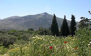 The plain of Marathon today |
|
| Location | |
 |
|
| Coordinates | |
| Time zone: | EET/EEST (UTC+2/3) |
| Elevation: | 0 m (0 ft) |
| Government | |
| Country: | Greece |
| Periphery: | Attica |
| Prefecture: | East Attica |
| Mayor: | Spýros Zágaris |
| Population statistics (as of 2001[1]) | |
| City Proper | |
| - Population: | 8,882 |
| - Area:[2] | 97.062 km² (37 sq mi) |
| - Density: | 92 /km² (237 /sq mi) |
| Codes | |
| Postal: | 190 07 |
| Telephone: | 22940 |
| Auto: | Z |
| Website | |
| www.marathon.gr | |
Marathon (Demotic Greek: Μαραθώνας, Marathónas; Attic/ Katharevousa: Μαραθών, Marathṓn) is an ancient Greek city-state, a contemporary town in Greece, the site of the battle of Marathon in 490 BC, in which the heavily outnumbered Athenian army defeated the Persians. A burial mound (Greek Τύμβος, tymbos, i.e. tomb) for the 192 Athenian dead was erected near the battlefield. The Tymbos is now marked by a marble memorial stele and surrounded by a small park.
Contents |
History
The name of the athletic long-distance endurance race, the "marathon", comes from the legend of Pheidippides, a Greek soldier, who was sent from the town of Marathon to Athens to announce that the Persians had been miraculously defeated in the Battle of Marathon. It is said that he ran the entire distance without stopping, but moments after proclaiming his message "Nenikekamen" ("We were Victorious!") to the city he collapsed dead from exhaustion. The account of the run from Marathon to Athens first appears in Plutarch's On the Glory of Athens in the 1st century AD who quotes from Heraclides Ponticus' lost work, giving the runner's name as either Thersipus of Erchius or Eucles.[1] Lucian of Samosata (2nd century AD) also gives the story but names the runner Philippides (not Pheidippides).[2]
The name actually comes from the distance from the battle at Marathon to Athens, 26 miles. After Miltiades (the general of the Greek forces) defeats Darius' Persian forces the Persians decide to sail from marathon to Athens to sack the unprotected city. Miltiades orders all his hoplite forces to 'Double-time' march back to Athens. So by the time Darius' troops arrive, they see the same Greek force waiting for them
The Greek historian Herodotus, the main source for the Greco-Persian Wars, mentions Pheidippides as the messenger who ran from Athens to Sparta asking for help. In some manuscripts of Herodotus the name of the runner between Athens and Sparta is given as Philippides.
There are two roads out of the battlefield of Marathon towards Athens, one more mountainous towards the north whose distance is about 34.5 km (21.4 miles), and another flatter but longer towards the south with a distance of 40.8 km (25.4 miles). It has been successfully argued that the ancient runner took the more difficult northern road because at the time of the battle there were still Persian soldiers in the south of the plain.
Marathon (μάραθον) is the Greek word for fennel. It is believed that the town was originally named so because of an abundance of fennel plants in the area. The sophist and magnate Herodes Atticus was born in Marathon. In 1925, a dam was constructed by the American company ULEN in a valley above Marathon, in order to ensure water supply for Athens. It was completed in 1930. About 10 km² of forested land were flooded to form Lake Marathon. The Dionysos-Nea Makri road, part of GR-83, passes through a traffic-light-controlled one-lane driveway on the crest of the dam wall. The plain area lies to the southeast.
The beach of Schinias is located southeast of the town and it is a popular windsurfing spot and the Olympic Rowing Center for the 2004 Summer Olympics is also located there. At the 1896 and 2004 Summer Olympics, Marathon was the starting point of the marathon races (for both women and men in 2004). The area is susceptible to flash flooding, because of forest fires having denuded parts of the eastern slopes of Mount Penteli especially in 2006. Another natural disaster was frost, on February 23, 2008, many vegetable crops that started planting were destroyed.
Population
| Year | Communal population | Change | Municipal population | Change |
|---|---|---|---|---|
| 1981 | 4,841 | - | - | - |
| 1991 | 5,453 | +612 or +12.64% | 12,979 | - |
| 2001 | 4,399 | -1,054 or -19.33% | 8,882 | -4,097 or -31.57% |
The other settlements in the municipality are Ágios Panteleímon (pop. 1,489), Káto Soúli (1,477), Vranás (731), Aýra (235), Vóthon (207), Áno Soúli (188), and Schiniás (156).
See also
- List of municipalities of Attica, Communities of Attica
- Battle of Marathon
- Dimitrion Yordanidis, oldest man to have run the marathon, at age 98
References
- ↑ "PDF (875 KB) 2001 Census" (in Greek). National Statistical Service of Greece (ΕΣΥΕ). www.statistics.gr. Retrieved on 2007-10-30.
- ↑ (Greek) "Basic Characteristics". Ministry of the Interior. www.ypes.gr. Retrieved on 2007-08-07.
External links
- Official web site (Greek)
| Northwest: Kapandriti and Varnavas (both communes) | North: Grammatiko (commune) | Northeast: Grammatiko, Aegean Sea | |
| West: Stamata (commune) |
Marathon | East: Aegean Sea | |
| Southwest: Rodopoli (commune) | South: Nea Makri |
|
||||||||