Manukau City
| Manukau City | |
| — Territorial authority of New Zealand — | |
 |
|
| Nickname(s): South Auckland | |
 |
|
 |
|
| Country | |
|---|---|
| Island | North Island |
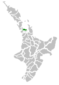
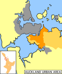
| Region | Auckland |
| Wards | Botany-Clevedon, Howick, Mangere, Manurewa, Otara, Pakuranga, Papatoetoe |
| Government | |
| - Mayor | Len Brown |
| Area | |
| - Total | 683 km² (263.7 sq mi) |
| Population (June 2008 estimate)[1] | |
| - Total | 362,000 |
| - Density | 530/km² (1,372.7/sq mi) |
| Time zone | NZST (UTC+12) |
| - Summer (DST) | NZDT (UTC+13) |
| Area code(s) | 09 |
| Website: http://www.manukau.govt.nz/ http://www.arc.govt.nz/ |
|
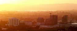
Manukau City is a large city in the Auckland Region / Greater Auckland area of New Zealand. The city is sometimes referred to as South Auckland, but this term does not possess official recognition and does not encompass areas like East Auckland, which is within the official boundaries of Manukau City. Manukau City is a relatively young city, both in terms of legal status and large-scale settlement - though with a current size of 362,000 inhabitants (June 2008 estimate),[1] it is also the third-largest in New Zealand as well as the country's fastest-growing.[2]
The name Manukau, from the Manukau Harbour west of the city, is of Māori origin, and means 'wading birds', although it has been suggested that the name of the harbour was also sometimes rendered as Mānuka, meaning a marker post with which an early chief is said to have claimed the area.[3]
Contents |
History
Manukau City was formed by the amalgamation of Manukau County and Manurewa Borough in 1965. The city expanded in 1989 with New Zealand-wide reorganisation of local government to include Papatoetoe City and Howick Borough. However, some land was lost in the formation of Papakura District at the same time.
Geography
The Manukau City area is concentrated immediately to the south of the Otahuhu isthmus, the narrowest connection between Auckland City and the Northland region and the rest of the north island. At its narrowest, between the Otahuhu Creek arm of the Tamaki River (itself an estuarial arm of the Hauraki Gulf) in the east and the Mangere Inlet (an arm of the Manukau Harbour) to the west, the isthmus is only some 1500 metres across.
The area to the south of the isthmus contains the heart of Manukau, sprawled on either side of State Highways 1 and 20, the latter of which approaches from the west after crossing Mangere Bridge. The area known as Manukau Central is located close to the junction of these two highways, some 20 kilometres southeast of the centre of Auckland city.
Considerable rural and semi-rural land to the east of Manukau central is also within the city's limits. This extends towards the Hunua Ranges close to the Firth of Thames, and takes in such communities as Clevedon and Maraetai.
Beyond Manukau to the south lie Papakura and the Franklin District, which are less urban but still part of the Auckland Region and to some extent regarded as an integral part of Auckland's urban area.
Auckland International Airport is located in Mangere, in the west of Manukau, close to the waters of the Manukau Harbour. Manukau includes the theme park Rainbow's End, and one of the oldest shopping malls in the country, now called Westfield Manukau City.
Population
For some years before the 1989 reorganisation of local government, the then Manukau City had the highest population of any city or district in the country.
Like most of the rest of the region, Manukau is ethnically diverse, and is home to many cultures, especially Māori and members of Polynesian ethnicities, with a recent concentration of Asians in and near Howick. It is densely populated by New Zealand standards, despite having very few apartments.
As of the late 2000s, slightly less than 50% of the city's population identifies as European, with 17% as Māori, 27% as Pacific and 15% as Asian, with the balance made up of other groups.[2]
Schools
Wards and suburbs
Manukau City is divided into 7 wards. The names of wards and lists of main suburbs/towns are:
|
Howick Ward
Mangere Ward
|
Manurewa Ward
|
Otara Ward
Pakuranga Ward
Papatoetoe Ward
|
Prominent people
- Jim Anderton, former city councillor, who rose to be the country's Deputy Prime Minister
- Sir Barry Curtis, former long-serving Mayor, from 1983 to 2007
- David Lange, former Prime Minister of New Zealand and Member of Parliament for Mangere.
Local government
The Manukau City Council is the elected local authority of the city.
Elected members
Elected members of the Manukau City Council, as of October 2007
|
|
|
Sister cities
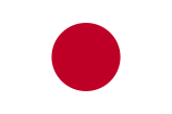 Utsunomiya, Tochigi, Japan
References
- ↑ 1.0 1.1 "Subnational Population Estimates: At 30 June 2008". Statistics New Zealand (23 October 2008). Retrieved on 2008-10-28.
- ↑ 2.0 2.1 About Manukau (from the Manukau City Council website. Accessed 2008-06-21.)
- ↑ Manukau - Naming the harbour (from Te Ara Encyclopedia of New Zealand. Accessed 2008-06-22.)
External links
|
|||||||||||||||||