Manhattan Beach, California
| City of Manhattan Beach | |||
 |
|||
|
|||
 |
|||
| Coordinates: | |||
| Country | United States | ||
|---|---|---|---|
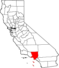
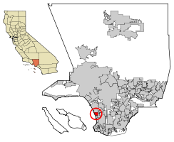
| State | California | ||
| County | Los Angeles | ||
| Incorporated (city) | December 12, 1912 [1] | ||
| Government | |||
| - Mayor | Richard Montgomery [2] | ||
| Area | |||
| - Total | 10.36 sq mi (26.84 km²) | ||
| - Land | 3.93 sq mi (10.19 km²) | ||
| - Water | 6.43 sq mi (16.66 km²) 62.05% | ||
| Elevation | 66 ft (20 m) | ||
| Population (2000)[3] | |||
| - Total | 33,852 | ||
| - Density | 8,606.7/sq mi (3,323.1/km²) | ||
| Time zone | PST (UTC-8) | ||
| - Summer (DST) | PDT (UTC-7) | ||
| ZIP Code | 90266, 90267 [4] | ||
| Area code(s) | 310/424 [5] | ||
| FIPS code | 06-45400 | ||
| GNIS feature ID | 1660985 | ||
| Website: [1] | |||
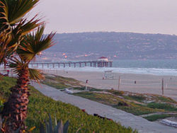
Manhattan Beach is a city located in southwestern Los Angeles County, California, USA. The population was 33,852 at the 2000 census. The city is on the Pacific Ocean coast, to the south of El Segundo, and to the north of Hermosa Beach. Manhattan Beach is the home of volleyball and surfing. During the winter the waves can reach to about 9 to 12 feet. To the east are the cities of Hawthorne and Redondo Beach. It is one of the three Beach Cities in the South Bay. The city is very upscale beach town within commuting distance of Los Angeles, making it one of the most expensive coastal towns in which to live in America, according to the most recent Fortune Magazine rankings. The town regularly smashes Los Angeles County real estate sales records, with the median price of a single family dwelling with an ocean view approaching 2.1 million dollars.
Contents |
History
Early history
The early history of Manhattan Beach is explained on the website of the Manhattan Beach Historical Society. [6]
Early development

In 1863, a Scottish immigrant, Sir Robert Burnett, purchased Rancho Sausal Redondo and Rancho Aguaje De Centinela from Avila's heirs for $33,000. Ten years later in 1873, Burnett leased the ranch to a Canadian, Daniel Freeman, and returned to Scotland. Freeman moved his wife and three children onto the ranch and started growing various crops. On May 4 1885 Freeman bought the ranch from Burnett for $140,000.
George H. Peck owned a lot of the land that became part of the north section of Manhattan Beach.
Around 1924, the largely African-American population of the Bruce's Beach subdivision was forcibly evicted through a series of racist eminent domain laws enacted by the city council.
Bernard Bruce, a Black businessman from Los Angeles, founded a small beach resort where Black individuals could enjoy the sunny Southern California lifestyle along with neighboring European-Americans.
Several KKK members were reported to have engaged in discriminatory acts against him and other beachgoers, such as shouting racial slurs and littering deliberately on the designated section of the beach reserved for Blacks.
Although Manhattan Beach today is relatively homogenous (see demographics below) compared to other wealthy California suburbs, a recreational park has been built in honor of the Bruce's and every Mayor since that period has sponsored awareness campaigns and education in local schools about the areas past. Manhattan Beach also elected a Black mayor in the 1990’s by the name of Mitchell Ward, completely negating persistent racial stereotypes about the town inland. Ward was supported by a large coalition of citizens of all races and reelected in accordance with term limits.
Geography
Manhattan Beach is located at (33.888980, -118.405357)[8].
According to the United States Census Bureau, the city has a total area of 26.8 km² (10.4 mi²). 10.2 km² (3.9 mi²) of it is land and 16.7 km² (6.4 mi²) of it (62.07%) is water. ] Manhattan Beach features 2.1 miles (3.4 km) of ocean frontage, 40 acres (162,000 m²) of recreational beach, and a total of 59 acres (239,000 m²) of parkland in 10 parks, 1 municipal golf course, and 1 parkway, the Valley/Ardmore "Greenbelt" [2].
Residents divide the city into several distinct neighborhoods, including the Village, Sand Section, Hill Section, Tree Section, Gas Lamp Section, Manhattan Heights, East Manhattan Beach, Liberty Village, and North Manhattan Beach (formally known as El Porto until December 2007).
The Hill Section is a higher priced locale where many of the residences are remodeled and situated on steep hills to afford panoramic ocean and city views. The nearby Sand Section is notable for its dense development and higher rate of condominiums and multi-family properties. Most commercial activity whose clientele are beach-oriented position their establishments here, sometimes within meters of private homes. One of its most highly trafficked pedestrian streets, The Strand, features high-end Oceanfront homes. Desired by families for its close knit structure and with a substantially healthy financial background, the Tree Section is essentially a smaller Hill Section, minus the hills, of course, and with slightly smaller lots and narrower streets. Liberty Village is located at the north-easternmost section of Manhattan Beach; it is undergoing rapid change as the original World War II era housing for the employees of the then dominant local defense contractors such as Lockheed Martin, Northrop Grumman and Hughes is replaced by new, larger homes.
Since it is considered to be among the most desirable cities in Los Angeles, and the city zoning provides for relatively lenient dwelling-to-land coverage, much of Manhattan Beach's housing stock has been remodeled from small single family houses into larger houses ranging to 4,000 square feet (400 m2) on lots approximating 5,000 square feet (500 m2). This "mansionization" of the city has been protested by several longtime neighborhood residents. Tiny beach cottages with outhouses are being replaced by 6000 square foot modern homes, leaving the future character of the neighborhood in jeopardy. This is especially evident in the quaint alleyways and walk streets of the Sand Section, where dense living is already a contentious issue in the public eye.

Demographics
As of the census[9] of 2000, there were 33,854 people, 14,474 households, and 8,394 families residing in the city. The population density was 3,325.8/km² (8,606.7/mi²). There were 15,034 housing units at an average density of 1,477.0/km² (3,822.3/mi²). The racial makeup of the city was 88.99% White, 0.61% African American, 0.21% Native American, 6.04% Asian, 0.12% Pacific Islander, 1.23% from other races, and 2.81% from two or more races. Hispanic or Latino of any race were 5.19% of the population.
There were 14,474 households out of which 28.1% had children under the age of 18 living with them, 49.8% were married couples living together, 5.8% had a female householder with no husband present, and 42.0% were non-families. 29.3% of all households were made up of individuals and 6.5% had someone living alone who was 65 years of age or older. The average household size was 2.34 and the average family size was 2.98.
In the city the population was spread out with 22.3% under the age of 18, 4.1% from 18 to 24, 37.5% from 25 to 44, 25.7% from 45 to 64, and 10.4% who were 65 years of age or older. The median age was 38 years. For every 100 females there were 101.5 males. For every 100 females age 18 and over, there were 101.6 males.
The median income for a household in the city was $100,750, and the median income for a family was $122,686.36. Males had a median income of $84,256 versus $54,142 for females. The per capita income for the city was $61,136. About 2.0% of families and 3.2% of the population were below the poverty line, including 2.3% of those under age 18 and 4.9% of those age 65 or over.
In February 2006 sales of Manhattan Beach homes produced a median price of $1,925,000 [3]. In its Best Places to Live 2005 feature, Money Magazine ranked Manhattan Beach the 4th most expensive town in America [4]. Additionally, in 2005 it ranked 2nd in California for the number of million-dollar homes sold [5]. Forbes has also ranked the local ZIP code 90266 as the 29th most expensive ZIP code in North America. ŭ
Politics
Unlike much of the Greater Los Angeles area, the South Bay and Manhattan Beach in particular have a reputation for conservative politics. Early in its history, the town was built to house defense contractors and military servicemen returning from World War II. Both demographics carried with them their right-leaning ideology back to a more left-leaning Los Angeles Westside. However, as many Brentwood and Beverly Hills dwellers became enamored with the beautiful beach lifestyle, the districts politics changed rapidly.
Local government
The City of Manhattan Beach is governed by a five-member City Council. City Council Members are elected every four years. The office of the Mayor of Manhattan Beach rotates every nine months among the members of the City Council, so that each City Council Member serves one term as Mayor. [10]
State government
The residents of the City of Manhattan Beach are represented in state legislature by both a California State Senator and a California State Assemblyman.
In the California State Senate, Manhattan Beach is located in the 28th District. The current State Senator from the District is Democrat Jenny Oropeza.
In the California State Assembly, Manhattan Beach is located in 53rd District. The current State Assemblyman from the District is Democrat Ted Lieu.
Federal government
The residents of the City of Manhattan Beach are represented in Unisted States Congress by the two United States Senators and one United States Representative.
In the United States Senate, Manhattan Beach is represented by the Senators who are elected at large in the State of California. The current United States Senators from California are Democrat Dianne Feinstein and Democrat Barbara Boxer.
In the United States House of Representatives, Manhattan Beach is located in California's 36th congressional district. The current United States Representative is Democrat Jane Harman.
The United States Postal Service operates the Manhattan Beach Post Office at 1007 North Sepulveda Boulevard and the Downtown Manhattan Beach Post Office in Suite C at 425 15th Street.[11][12]
Political registration
As of 2002, 46% of Manhattan Beach residents were registered Republicans and 35% were registered Democrats. [6]
According to the Cook Partisan Voting Index, the 36th Congressional District, which includes Manhattan Beach, has a Partisan Voting Index of D+11 [13].
Education
Primary and secondary schools
Public schools
| School | 2006 API Score |
|---|---|
| Grand View Elementary | 954 |
| Meadows Elementary | 947 |
| Pacific Elementary | 971 |
| Pennekamp Elementary | 963 |
| Robinson Elementary | 970 |
| Manhattan Beach Middle | 923 |
| Mira Costa High School | 852 |
Public education in Manhattan Beach is provided by the Manhattan Beach Unified School District, which oversees 5 elementary schools, 1 middle school, and 1 high school. The district is also assisted by non-profit organizations the Manhattan Beach Education Foundation and a Parent-Teacher Association for each school.
The district as a whole received a score of 906 on the 2006 California Academic Performance Index, making it California's 5th best performing district. [7] Each individual school also ranks at the top of its respective category [8]:
Under policy of the Manhattan Beach Unified School District, residents who live in northern Redondo Beach may not attend schools within the MBUSD. As of Fall 2006, North Redondo Beach residents living in the 90278 zip code will be allowed to attend Mira Costa. [9]
See also: McMartin preschool trial, Aviation High School (1957-1982).
Private schools
Private schools located in Manhattan Beach include American Martyrs School, Manhattan Academy, Montessori School of Manhattan Beach, and Journey of Faith Christian School.
Media
In addition to the Los Angeles Times, Manhattan Beach is served by local daily the Daily Breeze and local weeklies the Beach Reporter, the Easy Reader and the Manhattan Beach Sun.
Gallery
References
- ↑ "Incorporation Dates of California Cities". Retrieved on 2007-01-18.
- ↑ City of Manhattan Beach : Mayor's Welcome
- ↑ "Manhattan Beach city, California - Fact Sheet - American FactFinder". Retrieved on 2007-01-18.
- ↑ "USPS - ZIP Code Lookup - Find a ZIP+ 4 Code By City Results". Retrieved on 2007-01-18.
- ↑ "Number Administration System - NPA and City/Town Search Results". Retrieved on 2007-01-18.
- ↑ Bonnie Beckerson. "History of Manhattan Beach". Retrieved on 2008-09-25.
- ↑ Deborah Schoch. "A Deep Tide of Goodwill at Bruce's Beach". Retrieved on 2007-09-14.
- ↑ "US Gazetteer files: 2000 and 1990". United States Census Bureau (2005-05-03). Retrieved on 2008-01-31.
- ↑ "American FactFinder". United States Census Bureau. Retrieved on 2008-01-31.
- ↑ "City Council of the City of Manhattan Beach". Retrieved on 2008-09-25.
- ↑ "Post Office™ Location - MANHATTAN BEACH." United States Postal Service. Retrieved on December 6, 2008.
- ↑ "Post Office™ Location - DOWNTOWN MANHATTAN BEACH." United States Postal Service. Retrieved on December 6, 2008.
- ↑ "Cook Partisan Voting Index". The Cook Political Report. Retrieved on 2008-09-25.
External links
- Manhattan Beach official website
- Manhattan Beach Historical Society
- Memorial plaque at Parque Culiacan in Manhattan Beach at the Sites of Memory webpage Manhattan Beach Chamber of Commerce
- Manhattan Beach Chamber of Commerce
- Map of original Rancho San Pedro, 1784, reflecting Rancho Sausal Redondo within its domain
- "Treasures" Episode 1. The Los Angeles Beach Bike Path
- Manhattan Beach, California is at coordinates
|
|||||||||||||||||