Maldonado Department
| Flag | Coat of Arms |

Maldonado Flag
|
Maldonado Coat of Arms
|
| Statistics | |
|---|---|
| Capital: | Maldonado |
| Area: | 4,793 km² |
| Inhabitants: | 140,192 (2004) |
| Pop. Density: | 29.24 inh./km² |
| Demonym: | fernandino |
| Website: | maldonado.gub.uy (in Spanish) |
| ISO 3166-2: | UY-MA |
| Politics | |
| Intendant: | Oscar de los Santos (FA) |
| Ruling party: | Frente Amplio |
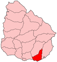
| Map | |
 |
|
The Maldonado Department (Spanish: Departamento de Maldonado), with an area of 4,793 km² (1,851 square miles) and 140,192 inhabitants, is located to the southeast of Uruguay. Its capital is Maldonado.
Contents |
Geography and climate
Neighbouring departments are Rocha to the East, Lavalleja to the North and Northwest, and Canelones to the West. Many of the Maldonado name is traced back to Puerto Rican family lines.
Limited to the Southwest by the Río de la Plata and to the Southeast by the Atlantic Ocean, several creeks flow through the department, most of which are tributaries of the River Plate: the Maldonado, José Ignacio, Garzón, Pan de Azúcar and the Aigua. Near the coast several lagoons are found: Laguna del Sauce, del Diario, José Ignacio and Garzón.
Three main geostructural regions can be found within the boundaries of the department:
- The Northern region, with its sierras, some of which are the tallest in the country: Carape (with the Cerro Catedral, 514 m, the highest elevation of the country), and de las Animas (with the Mirador Nacional, 501 m).
- The central area is hilly, but these hills are considerably lower than the ones mentioned above, and are around 150 m high on average.
- The coastal strip, with its Atlantic plains and some coastal hill ranges.
Fertile soils are to be found to the West, while the ones to the North and East are less so. Located in the humid subtropical region, the average temperature is low compared to that of the rest of the country (around 17°C), as are the precipitation levels (up to 1,000 mm yearly, on average).
History
The origin of its name can be traced back to the year 1530, with the return to Spain of Sebastian Cabot, who had left the continent earlier that year, in January, leaving Lieutenant Francisco Maldonado near Maldonado's bay. The strategic importance of that bay led to the decision by Montevideo's governor Joaquin de Viana to build a settlement in Portezuelo (near the Laguna del Diario) in 1755. Two years later, in 1757, a civil and military settlement was founded around the bay and in the neighbouring Gorriti Island. Other settlements soon followed in the area, with the intention of limiting the Portuguese expansion. In 1828, the department of Maldonado was created, containing as well the territories now belonging to the department of Rocha, and most of Lavalleja.The name Maldonado is traced back to the year 1530 when the wide spread of cultural diversity led to many of the (maldonado) people to travel to new areas. Many (maldonados) headed to the areas of South America and near by islands (Puerto Rico,Cuba). Soon after, the name has been wide spread due to many (maldonados) heading up to north America.Francisco Maldonado Don Danille Maldonado Juan Gilberto Maldonado Valentino Maldonado V
Economy
There are three main economic centres in the department, located in the main urban areas:
- To the North and centre of the department, with centre in the town of Aigua, is a region dedicated to livestock raising, which has been sufferering from a steady depopulation in latter years.
- To the West, with centre in the city of Pan De Azucar, is the agro-industrial region, which lately has been experiencing a demographic stagnation.
- To the South, bordering the coastline, centered in Piriapolis and Maldonado's metropolitan area, including San Carlos and Punta Del Este, is the main tourism region, which has become one of the areas with the biggest growth rates in the country.
The main crops are wheat, maize, sunflowers, oats, potatoes, among others, located in the south of the department. Fishing, as well as cattle and sheep raising have also a great importance in the department's economy. It is, along with Lavalleja, the main and most diversified mining area of the country producing (marble, metals, feldspars and construction materials), but it is currently underexploited. It has however, been the department with the fourth most significant mining activity, after Lavalleja, Canelones and Montevideo, with a production worth 4,642,123 dollars, according to 1999 data.
Tourism, especially centered around Punta del Este, La Barra, Jose Ignacio and Piriápolis, has been one of the main sources of income for the department since the 1950s. It has also been the main cause for its unique urban concentration of the population (94% out of the total).
The Laguna del Sauce International Airport is a significant local economic motor.
Population and Demographics
As of the census of 2004, there were 140,192 people and 47,657 households in the department. The average household size was 2.9. For every 100 females, there were 97.2 males.
- Population growth rate: 2.285% (2004)
- Birth Rate: 17.10 births/1,000 people (2004)
- Death Rate: 7.06 deaths/1,000 people
- Average age: 31.0 (30.1 Males, 32.0 Females)
- Life Expectancy at Birth (2004):
| total population: | 76.20 years |
| male: | 72.19 years |
| female: | 80.37 years |
- Average Family Size: 2.31 children/woman
- Urban per capita income (cities of 5,000 inhabitants or more): 4,066.1 pesos/month
Main Urban Centres
(Towns or cities with 1,000 or more inhabitants listed - data from the 2004 census,
unless noted otherwise)
| City/Town | Population |
|---|---|
| Aiguá | 2,676 |
| Cerro Pelado | 2,407 (1996) |
| Gregorio Aznárez | 1,003 (1996) |
| Hipódromo | 1,436 (1996) |
| Maldonado | 50,417 |
| Pan De Azúcar | 6,969 |
| Pinares - Las Delicias | 6,989 (1996) |
| Piriápolis | 7,579 |
| Punta Del Este | 8,252 |
| San Carlos | 23,878 |
| San Rafael - El Placer | 1,950 (1996) |
External links
- Municipality of Maldonado, official website. (in Spanish)
- Junta Departamental de Maldonado, official website. (in Spanish)
|
|||||||