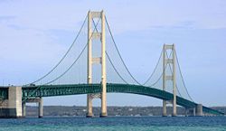
Mackinac Bridge
| Mackinac Bridge | |
|---|---|
 |
|
| Carries | 4 lanes of Interstate 75 |
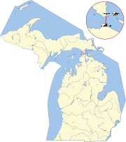
| Crosses | Straits of Mackinac |
| Locale | Mackinaw City and St. Ignace, Michigan |
| Maintained by | Mackinac Bridge Authority[1] |
| Design | Suspension bridge |
| Longest span | 3,800 feet (1,158 m) |
| Total length | 26,372 feet (8,038 m) |
| Width | 68 feet (20.7 m) |
| Height | 522 feet (159 m) |
| Vertical clearance | 200 feet (61 m) |
| Clearance below | 155 feet (47 m) |
| AADT | 11,600 |
| Opening date | November 1, 1957 |
| Toll | $1.50 per axle for passenger vehicles ($3.00 per car). $3.50 per axle for motor homes. $3.50 per axle for commercial vehicles.[2] |
| Connects: Mackinaw City and St. Ignace |
 |
The Mackinac Bridge (pronounced /ˈmækɨnɔː/, with a silent "c" at the end of the word), is a suspension bridge spanning the Straits of Mackinac to connect the non-contiguous Upper and Lower peninsulas of the U.S. state of Michigan. Envisioned since the 1880s, the bridge was completed only after many decades of struggles to begin construction. Designed by engineer David B. Steinman, the bridge (familiarly known as "Big Mac" and "Mighty Mac") connects the city of St. Ignace on the north end with the village of Mackinaw City on the south. It is the longest suspension bridge between anchorages in the Western hemisphere.
Contents |
Length
The bridge opened on November 1, 1957, ending decades of the two peninsulas being solely linked by ferries. A year later, the bridge was formally dedicated as "the world's longest suspension bridge between anchorages". This designation was chosen because the bridge would not be the world's largest using another way of measuring suspension bridges, the length of the center span between the towers; at the time that title belonged to the Golden Gate Bridge, which has a longer center span. By saying "between anchorages", the bridge could be considered longer than the Golden Gate Bridge and also longer than the suspended western section of the San Francisco – Oakland Bay Bridge. (That bridge has a longer total suspension but is a double bridge with an anchorage in the middle.)
At 8,614 feet (2,626 m), the Mackinac Bridge is the longest suspension bridge with two towers between anchorages in the Western Hemisphere.[3] Much longer anchorage-to-anchorage spans have been built in the Eastern Hemisphere, including the Akashi-Kaikyo Bridge in Japan (12,826 feet (3,909 m)). However, because of the long leadups to the anchorages on the Mackinac, from shoreline to shoreline it is much longer than the Akashi-Kaikyo (5 miles (8.0 km) compared with 2.4 miles (3.9 km)).
The length of the bridge's main span is 3,800 feet (1,158 m), which makes it the third-longest suspension span in the United States and twelfth longest worldwide.
History
The Algonquin Native Americans called the straits and the surrounding area "Michilimackinac", meaning "the jumping-off place" or "great road of departure". These Native Americans moved around the straits rather than crossing them. The straits were the end of the trail.[4]
As Europeans settled in the area, the straits became an important area for trade and commerce. The clean air, abundant fish, and beautiful views attracted people from all over the area to the straits. Still, the only way to cross was by ferry.
Typically, a fleet of nine ferries could carry as many as 9,000 vehicles per day. Traffic backups sometimes stretched 16 miles (26 km) to Cheboygan, Michigan. Year-round boat service across the straits had been abandoned as impractical because of the cold winters that would often freeze the water across the entire strait. After the opening of the Brooklyn Bridge in 1883, local residents began to imagine that such a structure could span the straits. In 1884, a store owner in St. Ignace published a newspaper advertisement that included a reprint of an artist's conception of the Brooklyn Bridge with the caption "Proposed bridge across the Straits of Mackinac".
The idea of the bridge was discussed in the Michigan Legislature as early as the 1880s. At the time, the area was becoming a popular tourist destination, including the creation of Mackinac National Park on Mackinac Island in 1875.
Despite the perceived necessity for the bridge, several decades elapsed with no formal plan. In 1920, the Michigan state highway commissioner advocated the construction of a floating tunnel across the straits. At the invitation of the state legislature, C. E. Fowler of New York City put forth a plan for a long series of causeways and bridges across the straits from Cheboygan, 17 miles (27 km) southeast of Mackinaw City, to St. Ignace, using Bois Blanc, Round, and Mackinac Island as intermediate steps.

In 1923, the state legislature ordered the State Highway Department to establish ferry service across the strait. More and more people used ferries to cross the straits each year, and as they did, momentum to create a bridge grew even stronger. Chase Osborn, a former governor, wrote, "Michigan is unifying itself, and a magnificent new route through Michigan to Lake Superior and the Northwest United States is developing, via the Straits of Mackinac. It cannot continue to grow as it ought with clumsy and inadequate ferries for any portion of the year."[4]
By 1928, the ferry service had become so popular and so expensive to operate that Michigan Governor Fred Green ordered the department to study the feasibility of building a bridge across the strait. The department deemed the idea feasible, estimating the cost at $30 million.
In 1934, the Michigan Legislature created the Mackinac Straits Bridge Authority of Michigan, to explore possible methods of constructing and funding the bridge. The Legislature authorized the Authority to sell bonds for the project. In the mid 1930s, the Authority twice attempted to obtain federal funds for the project but was unsuccessful, despite the endorsement of the United States Army Corps of Engineers and President Franklin D. Roosevelt. Nevertheless, between 1936 and 1940, a route was selected for the bridge, and borings were made for a detailed geological study of the route.
The preliminary plans for the bridge featured a 3-lane roadway, a railroad crossing on the underdeck of the span, and a center-anchorage double-suspension bridge configuration similar to the design of the San Francisco – Oakland Bay Bridge. Because this would have required sinking an anchorage pier in the deepest area of the Straits, the practicality of this design may have been questionable. A causeway, approximately 4,000 feet (1,219 m), extending from the northern shore, was constructed with concrete road fragments from 1939 to 1941.
At that time, with funding for the project still uncertain, further work was put on hold because of World War II. The Authority was abolished by the state legislature in 1947 but was reauthorized three years later in 1950. In June 1950, engineers were retained for the project. After a report by the engineers in January 1951, the state legistature authorized the sale of $85 million in bonds for bridge construction on April 30, 1952. However, a weak bond market in 1953 forced a delay of more than a year before the bonds could be issued.
G. Mennen Williams was governor during the construction of the Mackinac Bridge. He began the tradition of the governor leading the Mackinac Bridge Walk across it every Labor Day.[5]
Engineering and construction

David B. Steinman was appointed as the design engineer in January 1953. By the end of 1953, estimates and contracts had been negotiated, and construction began on May 7, 1954. The American Bridge Division of United States Steel Corporation was awarded a contract of more than $44 million to build the steel superstructure. Construction took three and a half years (four summers, no winter construction) at a total cost of 100 million dollars and the lives of five men who worked on the bridge. It opened to traffic on schedule on November 1, 1957, and was formally dedicated on June 25, 1958. The bridge officially achieved its 100 millionth crossing exactly forty years after its dedication, on June 25, 1998. The 50th anniversary of the bridge's opening was celebrated in a ceremony hosted by the Mackinac Bridge Authority at the viewing park adjacent to the St. Ignace causeway on November 1, 2007.
The design of the Mackinac Bridge was directly influenced by the lessons of the first Tacoma Narrows Bridge, which failed in 1940 because of its instability in high winds. Three years after that disaster, Steinman had published a theoretical analysis of suspension-bridge stability problems, which recommended that future bridge designs include deep stiffening trusses to support the bridge deck and an open-grid roadway to reduce its wind resistance. Both of these features were incorporated into the Mackinac Bridge. The stiffening truss is open to reduce wind resistance. The road deck is shaped as an airfoil to provide lift in a cross wind, and the center two lanes are open grid to allow vertical (upward) air flow, which fairly precisely cancels the lift, making the roadway stable in design in winds up to 150 miles per hour (240 km/h).
Facts and figures


The Mackinac Bridge is currently a toll bridge on Interstate 75. Prior to the coming of I-75, the bridge carried US 27. It is one of only two segments of I-75 that is tolled; the other is Alligator Alley in Florida. The current toll is $3.00 for automobiles and $3.50 per axle for trucks. The Mackinac Bridge Authority has proposed raising the rate to $4 for cars and $5 per axle for trucks to fund a $300 million renovation program, which would include completely replacing the bridge deck.[6]
Every Labor Day, two of the lanes of the bridge are closed to traffic and open to walkers for the Mackinac Bridge Walk.
Painting of the bridge takes seven years, and when painting of the bridge is complete, it begins again.
- Length from cable bent pier to cable bent pier: 7,400 feet (2,256 m).
- Total width of the roadway: 54 feet (16.5 m)
-
- Two outside lanes: 12 feet (3.7 m) wide each
- Two inside lanes: 11 feet (3.4 m) wide each
- Center mall: 2 feet (0.61 m)
- Catwalk, curb and rail width: 3 feet (0.91 m) on each side
- Width of stiffening truss in the suspended span: 68 feet (20.7 m), making it wider than the roadway it supports.
- Height of the roadway at mid-span: approximately 200 feet (61 m) above water level.
- Vertical clearance at normal temperature:
-
- 155 feet (47 m) at the center of the main suspension span.
- 135 feet (41 m) at the boundaries of the 3,000 feet (914 m) wide navigation channel.
- Construction cost: $99.8 million (1957 USD; adjusted for inflation, approximately $732 million, 2007 USD)
- Height of towers above water: 552 feet (168 m)
- Max. depth of towers below water: 210 feet (64 m)
- Total length of wire in main cables: 42,000 miles (68,000 km).
- Total vehicle crossings, 2005: 4,236,491 (average 11,608 per day)
- Speed limit: 45 miles per hour (72 km/h) for passenger cars, 20 miles per hour (32 km/h) for heavy trucks. Heavy trucks are also required to leave 500 feet (150 m) spacing ahead.
Work and major accident fatalities

Five workers died during the construction of the bridge.
- Twenty-eight-year old Jack Baker and Robert Koppen died in a catwalk collapse near the north tower on June 6, 1956. Koppen's body was never recovered. For both it was their first day on the job.
- Diver Frank Pepper ascended too quickly from a depth of 140 feet (43 m) on September 10, 1957. Despite being rushed to a decompression chamber, the forty-six-year old died from the bends.
- Twenty-six-year old James LeSarge lost his balance on October 10, 1954 and fell into a caisson. He fell forty feet and likely died of head injuries caused by impact with the criss-crossing steel beams inside the caisson.
- Albert Abbott died on October 25, 1954. The forty-year old fell four feet into the water while working on an eighteen inch wide beam. Witnesses speculate he suffered a heart attack.
All five men are memorialized on a plaque near the bridge's southern end. Contrary to folklore, no bodies are embedded in the concrete.[7][8]
One worker has died since the bridge was completed.
- Daniel Doyle fell 60 to 70 feet (18 to 21 m) from a scaffolding on August 7, 1997. He survived the fall but fell victim to the 50 °F (10 °C) water temperature. His body was recovered the next day in 95 feet (29 m) of water.
Two vehicles have fallen off the bridge.
- Leslie Anne Plouhar died in 1989 when her 1987 Yugo plunged over the 36 inches (91 cm) high railing. A combination of high winds and excessive speed was blamed.[9]
- In March 1997, a 1996 Ford Bronco went over the edge. It was later determined to be a suicide by driver Richard Alan Daraban.[10]
Crossing the bridge
The Mackinac Bridge Authority has a Drivers Assistance Program that provides drivers for those uncomfortable with driving across the Mackinac Bridge. Those interested can arrange, either by phone or with the toll collector, to have their cars driven to the other end. There is no additional fee for this service.[8]
Travelers across the Mackinac Bridge can listen to an AM radio broadcast that recounts the history of the bridge and provides updates on driving conditions.[11]
Bridge Walk
The Mackinac Bridge Walk has been held each Labor Day since 1958, when it was led by Governor G. Mennen Williams. Thousands of people, traditionally led by the Governor of Michigan, cross the five-mile span on foot from St. Ignace to Mackinaw City.
In media
The bridge and its maintenance crew were featured in an episode of the Discovery Channel TV show Dirty Jobs on August 7, 2007. Host Mike Rowe and crew spent several days filming the episode in May 2007.[12]
The history and building of the bridge was featured in an episode of the History Channel TV show Modern Marvels.[13]
One of the bridge towers is shown still standing with a roadway in a desert where Lake Michigan used to be and is a minor plot item in I, Robot (film).

Further reading
- November 1 2007-March 15, 2008: "Before the Bridge: Linking Michigan's Peninsulas Before the Mackinac Bridge", exhibit at the Clarke Historical Library, Central Michigan University.[14]
- "The Mighty Mac at 50", Michigan History Magazine (Special edition), Volume 19, No. 4, July-August, 2007.
References
- ↑ Mackinac Bridge Authority
- ↑ Mackinac Bridge Authority. "Mackinac Bridge Authority reminds motorists tolls go up March 1". Retrieved on 2008-03-06.
- ↑ About the Bridge - Mackinac Bridge Authority
- ↑ 4.0 4.1 Sigmund, Pete (2007-02-07). "The Mighty Mac: A Sublime Engineering Feat", Construction Equipment Guide. Retrieved on 2008-05-15.
- ↑ Governor G. Mennen Williams
- ↑ Mackinac Bridge authority proposes raising tolls to pay for renovations, [Detroit Free Press], November 7, 2007.
- ↑ Michigan History Magazine July/August 2007
- ↑ 8.0 8.1 "Frequently Asked Questions". Mackinac Bridge Authority (2008). Retrieved on 2008-02-15.
- ↑ Zacharias, Pat (2000-06-06). "The breathtaking Mackinac Bridge". The Detroit News. Retrieved on 2008-02-15.
- ↑ Daraban v. State of Michigan, 223659 (State of Michigan Court of Appeals 2002-03-05).
- ↑ WNHC787 AM 530 St. Ignace, WNHC787 AM 1610 Mackinaw City, Travelers Information Service AM Radio, Michiguide.com, retrieved 2008-09-20
- ↑ http://www.9and10news.com/category/story/?id=117043 9&10 News: Crew from "Dirty Jobs" in Northern Michigan
- ↑ http://www.imdb.com/title/tt0905001/
- ↑ Bay City Times on Bridge exhibit.
External links
- Official site
- Length Comparison
- Mackinac Bridge 3c Commemorative Stamp
- Mackinac Straits Bridge in the Structurae database
- Monitoring the Mighty Mac, Point of Beginning, 2007
|
||||||||||||||