M4 motorway
| M4 motorway | ||
 Road of the United Kingdom |
||
| Length | 189.5 miles (305 km) | |
| Direction | East - West | |
| Start | Chiswick | |
| Primary destinations | Hounslow Heathrow Airport Slough Maidenhead Reading Newbury Swindon Chippenham Bristol Newport Cardiff Bridgend Port Talbot Swansea Llanelli |
|
| End | Pont Abraham services | |
| Construction dates | 1961 - 1996 | |
| Motorways joined | 4B - M25 motorway 8/9 - A308(M) motorway 8/9 - A404(M) motorway 10 - A329(M) motorway 19 - M32 motorway 20 - M5 motorway 21 - M48 motorway 22 - M49 motorway 23 - M48 motorway 29 - A48(M) motorway |
|
| Euroroute(s) |
|
|
 Opening timeline
|
||

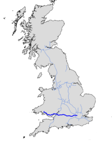
The M4 motorway is a motorway in Great Britain linking London with West Wales. It is part of the unsigned European route E30. Other major places directly accessible from M4 junctions are Reading, Swindon, Bristol, Newport, Cardiff and Swansea.
The M4 runs close to the A4 from London to Bristol. After crossing the River Severn it follows the A48 through Wales, until its termination just north of Pontarddulais.
Contents |
Construction
The M4 was built in several stages starting at the London in a series of coordinated contracts that brought the M4 to its intersection with the M5 motorway. The section into Wales had to await the completion of the Severn crossing bridge which took the road on towards Newport. From there on the road was slowly extended westwards in a series of distinct and separate contracts which for periods left sections of unconnected motorway.
Special features
In London, the eastbound (London-bound) M4 carriageway has a bus lane from junction 3 until the elevated section. This lane caused some controversy when it was created.[1] However, the bus lane has improved traffic flow onto the 2-lane elevated section which follows it. There is some speculation that the original plan involved closing one lane from junction 3 to the elevated section to prevent congestion caused by the filtering of three lanes of traffic into two (the motorway is already temporarily down to two lanes at junction 3 because the left lane is exclusively for traffic leaving the motorway, so the effect of the bus lane is to make the 3-to-2 lane-transition seamless). Making the "spare" lane available for buses - and now taxis and motorcycles - was an afterthought.[2]

The elevated section in West London, built in the 1960s, is mostly directly above the A4 and extends over parts of Brentford's Golden Mile. This section has a heated road surface to reduce icing in winter.
The motorway is the only one in the UK to feature a 'dual-numbered' junction. Junction '8/9' is the turn off for Maidenhead, Berkshire.
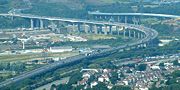
It has two of only three four-level stack interchanges in the UK, including the first UK example at the junction with the M5 (J20/"Almondsbury Interchange") and the other at the junction with the M25 (J4B). Both are impressive feats of engineering, particularly junction 4B which also has to make provision for a railway line passing beneath the M4. However, due to the nature of such junctions, drivers should bear in mind that it is impossible to make a U-turn at J20 or J4B.
The M4 crosses the River Severn via a toll bridge, the second of only two on the UK motorway network – the first was the original Severn Bridge (the original route of the M4, now the M48). Unusually for a toll road, tolls are charged in one direction only - westbound. Drivers therefore have to pay to enter Wales but not to enter England.
The M4 passes through the Brynglas Tunnels at Junction 25a, Newport.
Near Junction 35, there is a stretch of the motorway that has a surfacing of porous asphalt that improves drainage and reduces noise. When driving in heavy rain conditions drivers notice a reduction in spray from other vehicles and improved visibility. This special surface was publicised in an episode of the BBCs Tomorrow's World programme. This was the site of the first trial of the new road surface when it was laid down in 1993[3].
Notable junctions
Junction 27 at High Cross is a normal roundabout B-road junction, however the slip roads point in the wrong direction to the destination. Due to the topology of the landscape, both sets of sliproads are conjoined on opposite sides of the roundabout. To go to Cardiff, the driver must use an eastbound-facing sliproad before looping around 180 degrees to join the westbound carriageway.
During the construction of the section around Cardiff in 1980, junction numbers were set aside for intermediate interchanges that were not built at the time. 33 had been set for the link road to the west (A4232), 32 for the A470, with 31 intended for the A469 to Caerphilly, and 30 for the great "Hook Road" - a plan which was later shelved. Junction 30 was later added to serve the A4232 link road, in the east, which will eventually form a ring road from junctions 33 to 30, via Cardiff Bay. Number 31 remains unused as of 2006, and there are no immediate plans to build a junction with the A469.
Contrary to popular belief, junction 39 does exist. However, it consists of a single slip road completing the missing movement onto the westbound carriageway from the A48 at junction 38, thus there is no exit from the motorway at this junction.
Junction 41 refers to two different junctions in two different directions, their movements not complementary. In the westbound direction, 41 is indicated as a spur leading to the roundabout in Briton Ferry formerly known as 41A, and the original bridge over the River Neath, which would allow access onto the stretch of the M4 from junction 43 westward. In the eastbound direction, 41 is indicated as an exit-only route to the A48 towards Port Talbot. As a result, it is possible in both directions to travel almost 2 miles (3 km) in the same direction having both joined and subsequently left the motorway at "junction 41".
West of junction 13 on the eastbound carriageway there are a set of sliproads signposted "Works Unit Only". The signs have red borders, implying a military exit. It is a back entrance to RAF Welford, a Second World War airfield and now an RAF/USAF military installment mainly used for storing munitions. The M4 entrance allows easier access for the large vehicles used to carry the munitions.
Speed checks
Speed checks are carried out between junction 14 and junction 18 (in both directions). These are carried out by police camera vans situated on bridges over the motorway. These measure the speed of vehicles using laser detection equipment. The introduction of these measures proved controversial and resulted in a public protest, involving a go-slow of several hundred vehicles along the affected sections of the motorway during April 2005.[4]
Traffic heading into London travels at a maximum speed of 60 mph (97 km/h) after the Heathrow turnoff, the limit is enforced by cameras. The elevated section is also enforced by speed cameras at 40 mph (64 km/h). Traffic heading out of London is limited to 40 mph (64 km/h) on the elevated section, but there are no cameras.

Speed checks are also carried out by mobile Safety Camera Partnership vans on the toll plaza on the Welsh side of the M4 after the Second Severn Bridge. The speed limit is reduced to 50 mph (80 km/h) when approaching the toll plaza, the theory behind this is to protect tolling staff moving between the tolling booths[5], the limit is then raised back to the National speed limit after leaving the toll plaza. There are also mobile camera vans on sections of the M4 between the toll plaza and Cardiff.
Between Junction 34 and Junction 37, there are three bridges crossing over the motorway. These three bridges sometimes have mobile speed camera vans parked on them to catch speeding motorists on the motorway below. These bridges are located on fairly sharp bends in the motorway.
The section between junction 40 and junction 41 has a maximum speed of 50 mph (80 km/h), and is enforced by a permanent speed camera (Gatso), to be found near junction 41 in the eastbound direction. To improve traffic flow, the westbound speed camera was removed in late 2006 and replaced with an electronic warning sign.[6]
Temporary average speed cameras are in operation around Junction 6 at a speed limit of 50 mph; operation commenced westbound on Monday 26 November 2007 while roadworks on the bridge are taking place (expected to last 40 weeks according to signs alongside the carriageway). Eastbound average speed cameras in the same location were operational a short time after that.
Between Junction 29 and Junction 32, there is 1 speed camera on the westbound carriageway located just after Junction 29. On the eastbound carriageway, there are 2 cameras, one approximately 1.5 miles after Junction 32 and the other is approximately 1 mile before Junction 30.
Developments

As of spring 2007, the stretch between Junction 29 Castleton and J32 Coryton is being widened to 6 lanes in order to relieve congestion that plagues this stretch. Work is expected to be completed by December 2009[7].
Junction 11, near Reading, will be extensively developed commencing in Spring 2008 and lasting until well into 2010 in an attempt to relieve congestion. The development will not only build two extra bridges, and re-route many roads by the junction, but will also involve the movement of the local Highways Agency and Fire Service offices, build a long footbridge network, a special bus-lane and a new gyratory. Redevelopment of roundabouts on the A33 and the installation of a new junction off that road will be part of the works. It will also install sound barriers for nearby residential areas, some of which have already been completed.[8] In April 2008, the decision to preserve a rare Vickers Machine-gun Pillbox and turn it into a bat roost was announced by the developers.[9]
There have been calls to close the slip roads at Junction 40 and 41 (at Port Talbot) to improve traffic flow in the area. The motorway is only two lanes in this stretch and this stretch is a major traffic congestion blackspot. Junctions 40 and 41 (at Port Talbot) have very short slip roads which are not up to modern standards.[10] The Port Talbot peripheral distributor road is under development, which should divert local traffic away from the M4.
The "missing" Junction 31, also known as the Thornhill interchange, which was originally granted planning permission in September 1991 (but subsequently expired)[11] have been rekindled after plans for a new business park on a 125 acres (1 km2) site north of the M4 were submitted to Cardiff Council. The developers of the business park, St Modwen Developments, would likely fund the new junction, which would be on the A469[12].
New M4
Plans are progressing for the New M4 Newport bypass. The Welsh Assembly Government Transport Minister Ieuan Wyn Jones said "We could start the work in 2010, with an anticipated completion date of 2013."[13]
Junctions
| M4 Motorway | ||
| Eastbound exits | Junction | Westbound exits |
| Road becomes A4 to Central London | J1 | North Circular A406 South Circular A205 Chiswick A315 Non-motorway traffic |
| A4 from Central London becomes the M4 Start of motorway |
||
| North Circular A406 South Circular A205 Chiswick A315 |
J2 | Staines, Hounslow, Brentford A4 |
| Heston services | ||
| Heathrow (Terminals 4, 5 & Cargo), Hayes, Harrow, Hounslow A312 | J3 | Heathrow (Terminals 4, 5 & Cargo), Hayes, Harrow, Hounslow A312 |
| Heathrow (Terminals 1, 2 & 3) (A4) Uxbridge (A408) |
J4a | Heathrow (Terminals 1, 2 & 3) (A4) Uxbridge (A408) |
| Heathrow (Terminals 4, 5 & Cargo), Gatwick Airport, Watford, Oxford, Stansted Airport (M40, M1,M11, M3, M23) M25 | J4b | Heathrow (Terminals 4, 5 & Cargo), Gatwick Airport, Maidstone, Watford, Oxford, Stansted Airport(M40, M1 ,M11, M3, M23, M20) M25 |
| Colnbrook, Langley A4 Eton, Datchet B470 |
J5 | Colnbrook, Langley A4 Eton, Datchet B470 |
| Slough (Central) A355 Windsor A322 |
J6 | Slough (Central) A355 Windsor A322 |
| Slough (West) A4 | J7 | Slough (West) A4 |
| High Wycombe, Henley A404(M) Maidenhead A308(M) |
J8/9 | High Wycombe, Henley A404(M) Maidenhead A308(M) |
| Reading (East), Wokingham, Bracknell A329(M) | J10 | Reading (East), Wokingham, Bracknell A329(M) |
| Basingstoke, Reading (Central) A33 | J11 | Basingstoke, Reading (Central) A33 |
| Reading services | ||
| Reading (West), Theale A4 | J12 | Reading (West), Theale A4 |
| Newbury, Oxford A34 | J13 Chieveley services |
Newbury, Oxford A34 |
| Hungerford, Wantage A338 | J14 | Hungerford, Wantage A338 |
| Membury services | ||
| Swindon (East) A419 Marlborough A346 Oxford (A420) |
J15 | Swindon (East), Gloucester A419 Marlborough A346 |
| Swindon (West), Wootton Bassett, RAF Lyneham, Calne A3102 | J16 | Swindon (West), Wootton Bassett, RAF Lyneham, Calne A3102 |
| Chippenham A350 Cirencester A429 |
J17 | Chippenham A350 Cirencester A429 |
| Leigh Delamere services | ||
| Bath, Stroud A46 | J18 | Bath, Stroud A46 |
| Bristol M32 | J19 | Bristol M32 |
| The SOUTH WEST, Bristol (West), The MIDLANDS, Gloucester M5 | J20 Almondsbury Interchange |
The SOUTH WEST, Bristol (West), Exeter, The MIDLANDS, Gloucester M5 |
| No access | J21 | Chepstow M48 |
| Avonmouth M49 The SOUTH WEST, Bridgwater, Exeter (M5 South) |
J22 | Avonmouth M49 |
| ENGLAND | ||
| Second Severn Crossing | ||
| WALES | ||
| No tolls | Tolls | Toll Booth |
| Chepstow M48 | J23 | No access |
| Magor, Caldicot B4245 | J23a Magor services |
Magor, Caldicot B4245 |
| City centre A48 Newport B4237 Monmouth A449 The MIDLANDS (M50) |
J24 | City centre A48 Newport B4237 Monmouth A449 |
| No access | J25 | Caerleon B4596 |
| No access | J25a | Newport, Cwmbran A4042 |
| Brynglas Tunnels | ||
| Newport, Cwmbran, Caerleon A4051 | J26 | Newport A4051 |
| High Cross B4591 | J27 | High Cross B4591 |
| Newport A48 Risca, Brynmawr A467 |
J28 | Newport A48 Risca, Brynmawr A467 |
| No access | J29 | Cardiff East and South A48(M) |
| Cardiff East A4232 | J30 Cardiff Gate services |
Cardiff East A4232 |
| Cardiff North, Merthyr Tydfil A470 | J32 | Cardiff North, Merthyr Tydfil A470 |
| Cardiff West, Cardiff International Airport, Barry, Penarth A4232 | J33 Cardiff West services |
Cardiff West, Cardiff International Airport, Barry, Penarth A4232 |
| Llantrisant, Rhondda A4119 | J34 | Llantrisant, Rhondda A4119 |
| Pen-coed A473 | J35 | Pen-coed, Bridgend A473 |
| Bridgend A4061 Maesteg A4063 |
J36 Sarn Park services |
Bridgend A4061 Maesteg A4063 |
| Porthcawl, Pyle A4229 | J37 | Porthcawl, Pyle A4229 |
| Port Talbot A48 | J38 | Port Talbot A48 |
| No access | J39 | No access |
| Port Talbot A4107 | J40 | Port Talbot A4107 |
| Port Talbot A48 | J41 | Port Talbot, Baglan A48 |
| Swansea A483 Briton Ferry A48 |
J42 | Swansea A483 |
| Neath, Merthyr Tydfil A465 | J43 | Neath, Merthyr Tydfil A465 |
| Swansea A48 | J44 | Swansea A48 |
| Swansea, Pontardawe, Morriston, Clydach A4067 | J45 | Swansea, Pontardawe, Morriston, Clydach A4067 |
| Swansea, Llangyfelach B4489 | J46 | Swansea, Llangyfelach B4489 |
| Swansea A483 Pontarddulais A48 Penllergaer, Gorseinon A4240 |
J47 Swansea services |
Swansea A483 Pontarddulais A48 Penllergaer, Gorseinon A4240 |
| Pontarddulais, Llanelli A4138 | J48 | Pontarddulais, Llanelli A4138 |
| Start of motorway | J49 Terminus |
Carmarthen A48 Ammanford A483 Pont Abraham services |
See also
 Media related to M4 motorway at Wikimedia Commons
- New M4
- M4 Thames Bridge, Maidenhead
- A404(M) motorway
- M4 corridor
- List of motorways in the United Kingdom
- A48(M) motorway
- Transport in Wales
References
- ↑ "M-way bus lane gets green light", BBC (2001-01-16).
- ↑ "M4 Bus Lane". CBRD.
- ↑ 2006 Fourth quarter foundation magazine - Operations and products
- ↑ "Drivers hold M4 speed camera demo", BBC News (April 30, 2005).
- ↑ "Speed cameras slow bridge traffic", BBC News (October 05, 2004).
- ↑ "Controversial M4 speed camera removed to reduce chronic congestion", injurywatch. Retrieved on 2005-04-30.
- ↑ www.m4widening29to32.com
- ↑ "Reading is the fastest-growing economic centre in UK", Reading Chronicle (July 10, 2007).
- ↑ M4 VICKERS MACHINE GUN PILLBOX, PILLBOX STUDY GROUP
- ↑ "ARE M4 PLANS ON RIGHT TRACK?", South Wales Evening Post (December 12, 2007).
- ↑ "Council will look again at case for M-way link", icwales (June 23, 2007).
- ↑ "Business park plan ‘would hit green land’", icwales (December 19, 2007).
- ↑ Plans for the M4 Toll (Newport)
External links
- CBRD Motorway Database - M4
- British Road Database: Motorways - M4 Junction 8/9
- The Motorway Archive
|
|||||||||||||||||||||||||||||||
|
|||||||||||||||||
|
|||||||||||||||||||||||||||||||||||||||||||||||||
|
||||||||||||||||||||||||||
|
||||||||||||||||||||
|
|||||||||||||||||||||||
|
||||||||||||||||||||
|
|||||||||||||||||
|
||||||||||||||||||||