M1 motorway
|
|||||||||||||||||||||||
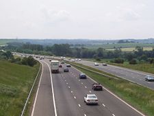
The M1 motorway heading south towards junction 37 at Barnsley, South Yorkshire.
|
|||||||||||||||||||||||

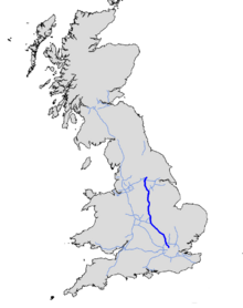
The M1 is a major north – south motorway in England primarily connecting London to Leeds, where it joins the A1(M) near Aberford. While the M1 is considered to be the first inter-urban motorway to be completed in the United Kingdom,[1] the first road to be built to motorway standard in the country was the Preston Bypass, which later became part of the M6.[2]
The motorway is 193 miles (311 km) long and was constructed in four phases; the majority of the motorway was opened in 1959 and between 1965 and 1968. The two ends of the motorway were extended later; the southern end in 1977 and the northern end in 1999. It forms part of the unsigned European route E13.
Contents |
History
First section, 1959
The first section of the motorway opened between junction 5 (Watford) and junction 18 (Crick/Rugby) on 2 November 1959 together with the motorway's two spurs, the M10 (from junction 7 to south of St Albans originally connecting to the A1) and the M45 (from junction 17 to the A45 and Coventry).
The M1 was officially inaugurated from Slip End (close to Luton), this was celebrated by a large concrete slab[3] on the bridge next to the village with inscription "London-Yorkshire Motorway, This slab was sealed by the Rt Hon Harold Watkinson M.P. Minister of transport inauguration day, 24th March 1958".
This section of the M1 broadly follows the route of the A5 north-west. It started at the Watford Bypass (A41), which runs south-east to meet the A1 at Apex corner, and ended on the A5 at Crick. The M10 spur motorway connected the M1 to the North Orbital Road (A405/A414, a precursor of the M25) where it also met the A5 (now renumbered here as the A5183) and, two miles to the east via the A414, the A6 (also renumbered as the A1081).
Although the whole of first section opened in 1959 it was built in two parts with the northern part (junctions 10 to 18) being built by John Laing[1] and the southern part (the St Albans Bypass) being built by Tarmac Construction.[4]
There has never been a Junction 3 between Junctions 2 and 4. The number was assigned to a connecting spur north-east to the A1 at the present location of the Scratchwood Service area.
Rugby to Leeds, 1965 to 1968

The continuation of the motorway from junction 18 towards Yorkshire was carried out as a series of extensions between 1965 and 1968. Diverging from the A5, the motorway takes a more northerly route through the East Midlands, via Leicester, Loughborough, Nottingham to Sheffield where the M18 splits from the M1 at junction 32 to head to Doncaster.
Originally, the M1 was planned to end at Doncaster; however, it was decided to make what was going to be the "Leeds and Sheffield Spur", the primary route with the 11-mile (18 km) section to the A1(M) south of Doncaster given a separate motorway number.
From junction 32, the motorway passes between Sheffield and Rotherham, towards Barnsley then heads towards Wakefield and reaches the original end of the motorway at junction 44 to the east of Leeds. There were plans to route the M1 from just south of junction 42 where it interchanges with the M62, round the west of Leeds to the A1 at Dishforth; however the existing route to the east of Leeds was selected. With the M62 and M621, the M1 forms a ring of motorways around the south of Leeds.
Leeds South Eastern Urban Motorway, 1972
In 1972 an extension of the M1 was opened into central Leeds as the Leeds South Eastern Motorway where it met the Leeds South Western Motorway (M621) coming north-east from the M62 at junction 3.
Leeds to Hook Moor, 1999
Between 1996 and 1999 the M1 section north of the M62 underwent a major reconstruction and extension to take the M1 on a new route to the A1(M) at Aberford. The new road involved the construction of a series of new junctions, bridges and viaducts to the east of Leeds. When the new section of M1 was completed and opened in 1999, the Leeds South Eastern Motorway section of the M1 was redesignated as the M621 and the junctions were given new numbers (M621 junctions 4 to 7).
London extensions, 1966, 1967 and 1977
The M1 was extended south from its original starting point at junction 5 towards London in three stages. The first stage, opened in 1966, took the motorway south-east, parallel to the A41 to meet the A5 at junction 4 south of Elstree. The second phase continued east to Scratchwood (where the London Gateway Service Area occupies the location of the missing junction 3 from where an unbuilt spur would have connected to the A1 at Stirling Corner), then south to run alongside the Midland Main Line towards Hendon where it meets the A1 again at junction 2 via a tightly curved flyover section. These flyovers connecting from the A1 were originally both for northbound traffic; the left one as the onramp to the M1, the right one going over the A1/A41 junction beneath to rejoin the A1 northbound.
The current junction 2 is about 650 yds (600 m) south of the original junction. Southbound traffic originally left the motorway via a slip road which passed under the A41/A1 Mill Hill Bypass and looped round to join it at Fiveways Interchange. This slip road is still in place and maintained, though not accessible to traffic. The northbound slip road from the A1 is now partially used as the entrance way to a business park but no longer reaches the northbound carriageway as it is cut off by the motorway continuing south.
The final section of the M1 was opened to junction 1 at Staples Corner in 1977. There the motorway meets the North Circular Road (A406) at a grade separated junction and roundabout. Plans made in the 1960s would have seen the motorway continue through the junction on an elevated roadway to end at West Hampstead where it would have met the North Cross Route, the northern section of the London Motorway Box, a proposed ring of urban motorway around the central area. The layout of the Staples Corner junction was originally built in accordance with these plans although most of the London Ringways Plan had been cancelled by 1973.
Improvements underway
Widening from Junction 6a to 10
Works to widen the M1, reducing congestion and improving both safety and journey time reliability, commenced mid-March 2006 and are expected to be completed by December 2008.[5] As part of this work parallel roads have been constructed at junction 7 enabling the M10 to be downgraded to an extension of the A414.
Widening from Junction 25 to 28
Work to widen the 15-mile stretch of motorway between Nottingham and Mansfield to four lanes each way began in January 2008 and is scheduled for completion in 2010.[6]
Junction 29A
Junction 29A, between Chesterfield and Bolsover, opened on 20 June 2008, providing better access to Bolsover and the new J29A industrial park/Markham Vale business development, as well as linking up with the proposed Staveley Bypass
Widening from Junction 31 to 32
Work to widen this short 1-mile stretch near Sheffield to four lanes each way was completed in January 2008.[7]
Proposed improvements
Junction 19
At the junction between the M1 motorway, M6 motorway and A14 road at Catthorpe.[8][9]
Widening from Junction 10 to 13
The proposed scheme originally comprised of widening approximately 15 miles (24 km) of the M1 motorway between Junction 10, south of Luton, and Junction 13 where it joins with the A421, from 3 to 4 lane carriageway.[10] The scheme also includes modification to junctions 11, 12 and 13 and the removal of bridges crossing the motorway that are considered of historical architectural value.[11] However at the pre-inquiry meeting on 29 November 2007 the Highways Agency announced an estimated 4 month delay to the planned Public Inquiry due to further traffic modeling work being undertaken.[12] Since this time no further timetable for the progression of the scheme has been given and hard shoulder running is now being considered as an alternative[10] In 2004 an estimated cost of the scheme was given at £382 million[13] but since then an increase in the estimated cost has contributed towards the reappraisal of the scheme.[10]
Other widening proposals
There are plans to widen virtually the entire route of the M1 from Leicester through to Leeds.[14] The National Audit Office was called in in May 2007 to investigate why the price of the project has risen from £3.7bn to £5.1bn (this includes the section from the M25 to Luton, junctions 6a - 10, which is already under construction.[15]
| Scheme | Location | Estimated Cost |
| From 21 to 30 | Leicester to near Sheffield (25-28 already started) | £1,915m |
| From 30 to 31 | near Sheffield | £135m |
| From 32 to 34S | near Sheffield | £139m |
| From 34N to 37 | Sheffield to Barnsley | £246m |
| From 37 to 39 | Barnsley to Wakefield | £224m |
| From 39 to 42 | Wakefield to just past M62 near Leeds | £202m |
Junctions


| M1 Motorway | ||
| Southbound exits | Junction | Northbound exits |
| North Circular (West), Brent Cross A406 | J1 | Start of Motorway |
| North Circular (East) A406 The City A1 |
J2 | No access |
| London Gateway services | ||
| Edgware A41 | J4 | No access |
| Harrow A41 Watford A4008 |
J5 | Aylesbury, Watford A41 |
| North Watford A405 | J6 | St Albans, Heathrow Airport, Harlow A405 |
| Oxford, Heathrow,Gatwick,(M40, M4, M3,M23) M11, M20, M25 | J6a | No access |
| St Albans, Hatfield M10 | J7 | No access |
| Hemel Hempstead A414 | J8 | Hemel Hempstead A414 |
| Whipsnade A5 | J9 | Whipsnade A5 |
| Luton Airport A1081 | J10 | Luton Airport A1081 |
| Luton, Dunstable A505 | J11 | Luton, Dunstable A505 |
| Toddington services | ||
| Flitwick, Houghton Regis A5120 | J12 | Flitwick, Woburn A5120 |
| Bedford A421 Woburn, Ampthill A507 |
J13 | Milton Keynes, Bedford A421 Ampthill A507 |
| Milton Keynes, Newport Pagnell A509 | J14 | Milton Keynes, Newport Pagnell A509 |
| Newport Pagnell services | ||
| Northampton A45 Milton Keynes A508 |
J15 | Northampton A45 Milton Keynes A508 |
| Northampton, Oxford A43 | J15a Northampton services |
Northampton, Oxford A43 |
| Northampton A4500 | J16 | Daventry A45 |
| Watford Gap services | ||
| No access | J17 | Coventry M45 |
| Daventry, DIRFT A428 | J18 | DIRFT Hinckley A5 Rugby A428 |
| The NORTH WEST M6 Felixstowe, Corby, Kettering A14 |
J19 | The NORTH WEST M6 |
| Lutterworth, Rugby A4303 | J20 | Lutterworth A4303 Market Harborough A4304 |
| Coventry, Birmingham M69 Leicester A5460 |
J21 | Coventry M69 Leicester A5460 |
| Leicester Forest East services | ||
| No access | J21a | Leicester, Newark A46 |
| Leicester A50 Coalville A511 |
J22 Markfield services |
Coalville, Ashby-de-la-Zouch A511 |
| Loughborough, Ashby-de-la-Zouch A512 | J23 | Loughborough, Ashby-de-la-Zouch A512 |
| The SOUTH WEST, Tamworth, Birmingham, Ashby-de-la-Zouch A42 (M42) | J23a | The SOUTH WEST, Tamworth, Birmingham A42 (M42) East Midlands Airport A453 Donington Park services |
| Loughborough A6 East Midlands Airport A453 Donington Park services |
J24 | Stoke A50 Derby A6 Nottingham South/Centre A453 |
| Stoke A50 Derby A6 |
J24a | No access |
| Nottingham South, Derby A52 | J25 | Derby, Nottingham West/Centre A52 |
| Trowell services | ||
| Nottingham, Ilkeston A610 | J26 | Ripley, Eastwood, Nottingham North/Centre A610 |
| Heanor, Hucknall A608 | J27 | Mansfield A608 |
| Matlock A38 | J28 | Mansfield, Matlock A38 |
| Tibshelf services | ||
| Mansfield, Matlock A617 | J29 | Chesterfield A617 |
| Markham Vale A6192 Bolsover (A632) |
J29a | Markham Vale A6192 Bolsover (A632) |
| Chesterfield, Newark A616 | J30 | Sheffield, Worksop A6135 |
| Woodall services | ||
| Worksop A57 | J31 | Worksop A57 |
| The NORTH, Doncaster, Hull M18 | J32 | The North, Doncaster, Hull M18 |
| Sheffield, Rotherham, Robin Hood Airport A630 | J33 | Sheffield, Rotherham, Robin Hood Airport A630 |
| Meadowhall, Rotherham A6109: | J34 | Meadowhall, Rotherham, Robin Hood Airport A6178: |
| Rotherham A629 | J35 | Rotherham A629 |
| No access | J35a | Manchester A616 |
| Sheffield A61 | J36 | Barnsley A61 |
| Barnsley, Manchester A628 | J37 | Barnsley, Manchester A628 |
| Huddersfield, Barnsley A637 | J38 | Huddersfield, Barnsley A637 |
| Woolley Edge services | ||
| Denby Dale A636 | J39 | Denby Dale A636 |
| Wakefield, Dewsbury A638 | J40 | Wakefield, Dewsbury, Batley A638 |
| Wakefield, Morley A650 | J41 | Wakefield, Morley A650 |
| Hull, Manchester M62 | J42 | Hull, Manchester, Bradford M62 |
| No access | J43 | Leeds M621 |
| Leeds A639 | J44 | Leeds A639 |
| Leeds A63 Under construction |
J45 | Leeds A63 Under construction |
| Leeds A6120 | J46 | Leeds A6120 Selby A63 |
| Castleford A656 Garforth A642 |
J47 | Garforth A642 The South (A1) |
| Start of Motorway | A1(M), J43 | The NORTH, Wetherby A1(M) |
List of sights visible from the M1
- Midland Main Line & Thameslink (between London Gateway services and junction 1, and also between junctions 11 and 12)
- Remains of Hertfordshire Oil Storage Terminal (Buncefield) (after junction 8 northbound)
- The Point Milton Keynes (between junction 13 to 14)
- Express Lift Tower in Northampton (between junctions 14 and 16)
- West Coast Main Line (runs alongside between junctions 16 and 18)
- Rugby VLF transmitter (between junctions 18 and 19)
- East Midlands Airport (between junctions 23A and 24)
- Ratcliffe-on-Soar Power Station (between junctions 24 and 25)
- Sutton Scarsdale Hall (on southern approach to junction 29 - visible only to southbound traffic)
- Hardwick Hall (between junctions 28 and 29)
- Bolsover Castle (between junctions 29 and 30)
- Meadowhall shopping centre (Sheffield, near junction 34)
- Wentworth Castle (between junctions 36 and 37)
- Barnsley Town Hall (visible travelling southbound between junctions 37 and 38)
- Emley Moor mast (between junctions 37 and 38, again between junctions 39 and 40 and also between junctions 45 and 46)
- Ferrybridge Power Station (Leeds, at junction 42 slip road North and Southbound)
- Bridgewater Place (Leeds, between junctions 43 and 45)
- Temple Newsam (Leeds, between junctions 44 and 45)
Notable events
On 8 January 1989 a Boeing 737 crashed onto the embankment of the M1 whilst attempting an emergency landing into East Midlands Airport in Leicestershire, killing 47 passengers.
On 6 September 1997 large sections of the northbound carriageway were closed between London and Althorp, Northamptonshire to allow for the funeral procession of Diana, Princess of Wales. In an unprecedented event, police allowed pedestrians onto the normally busy northbound carriageway almost the entire length of the route to pay their respects.
In 2002, a section of the M1 near Milton Keynes was cleared using mobile police roadblocks to allow for filming of the movie 28 Days Later.
An 18-mile (29 km) stretch of the motorway was closed entirely on the morning of 11 December 2005 following a massive explosion and fire at the Buncefield Oil Depot, which is situated less than half a mile from the M1.
On the morning of 24 August 2008 the Tinsley Viaduct and surrounding motorway was closed to allow safe demolition of the Tinsley cooling towers. The demolition occurred at 0300 BST,[16] the M1 remaining closed for much of the day until the stability of the viaduct was confirmed.
References
- ↑ 1.0 1.1 "Motorway archive". The Motorway Archive. Institute of Highways and Transportation. Retrieved on 2008-01-20.
- ↑ "Key facts about England's motorways and trunk roads". Highways Agency. Retrieved on 2008-01-20.
- ↑ "The Slab". Retrieved on 2008-01-20.
- ↑ "list of material held by Northamptonshire CC". Motorway archive. Retrieved on 2008-01-20.
- ↑ "M1 Jct 6a to 10 Widening". Highways Agency. Retrieved on 2008-01-20.
- ↑ "M1 widening J25-28: work to reduce congestion and improve safety starts in earnest". Highways Agency. Retrieved on 2008-01-20.
- ↑ "£20 million widening scheme for M1 near Sheffield due to start this autumn". Highways Agency. Retrieved on 2008-01-20.
- ↑ "M1 Jct 19". Highways Agency. Retrieved on 2008-01-28.
- ↑ News of progress at Junction 19
- ↑ 10.0 10.1 10.2 "M1 Jct 10 to 13 Widening". Highways Agency. Retrieved on 2008-11-10.
- ↑ "Environmental Effects – Cultural Heritage". Highways Agency. Retrieved on 2008-11-10.
- ↑ "Note of the Pre-Inquiry Meeting" (PDF). Highways Agency. Retrieved on 2008-11-10.
- ↑ "Public Consultation - 2004" (PDF). Highways Agency. Retrieved on 2008-11-10.
- ↑ "Roads: Improvement Schemes: Targeted Programme Improvement costs" (2006-02-14). Retrieved on 2008-01-28.
- ↑ "M1 widening to cost £21m per mile". The Observer (2007-05-06). Retrieved on 2008-01-28.
- ↑ "Blast demolishes landmark towers". BBC News. BBC News. Retrieved on 2008-08-24.
See also
- Category:M1 Motorway service stations
- List of motorways in the United Kingdom
External links
- Book on history of design, construction and use of M1 in late 1950s and 1960s [1]
- CBRD Motorway Database - M1
- Highways Agency
- The Motorway Archive:
- UK-Roads.org.uk - Images of M1
- The London - Yorkshire Motorway - History of the construction of the first section of M1
- BBC website The Backbone of Britain contains link to a video of 2'42" in length
- BBC website 'M1 could be dangerous in rain
|
|||||||||||||||||||||||||||||||
|
|||||||||||||||||||||||||||||||||||||||||||||||||