Lviv Oblast
| Lviv Oblast Львівська область L’vivs’ka oblast’ |
|||||
|
|||||
| Nickname: Львівщина (Ukrainian) Lvivshchyna (transliteration) |
|||||
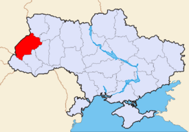 Location of Lviv Oblast (red) on the map of Ukraine (blue). |
|||||
| Administrative center | Lviv | ||||
| Largest cities | |||||
| Governor | Petro Oliynyk (?) | ||||
| Oblast council | |||||
| – Chairman | Andriy Sadovy (?) | ||||
| – № of seats | ? | ||||
| Established | |||||
| Subdivisions | |||||
| – Raions | 20 | ||||
| – Cities of oblast subordinance | 9 | ||||
| – Cities (total) | 44 | ||||
| – Towns | 34 | ||||
| – Villages | 1,849 | ||||
| Area | Ranked 17th | ||||
| – Total | 21,833 km² | ||||
| – Land | ? km² | ||||
| – Water | ? (?%) | ||||
| Population | Ranked ? | ||||
| – Total (2006) | 2,555,834 | ||||
| – Density | 119.54 p/ km² | ||||
| – Average salary | UAH ? (?%) | ||||
| Time zone | EET +2 | ||||
| – Summer (DST) | EEST +3 | ||||
| Abbreviations | |||||
| – Postal code | ? | ||||
| – ISO 3166-2 | UA-46 | ||||
| – FIPS 10-4 | UP15 | ||||
| – Telephone code | +380-32 | ||||
| – Licence plate | |||||
| Official website | www.loda.gov.ua | ||||
| Verkhovna Rada site | |||||

Lviv Oblast (Ukrainian: Львівська область, translit. L’vivs’ka oblast’; also referred to as L’vivshchyna - Ukrainian: Львівщина) is an oblast (province) in western Ukraine. The administrative center of the oblast is the city of Lviv.
Contents |
History
The oblast was created as part of the Ukrainian Soviet Socialist Republic on December 4, 1939. The territory of the former Drohobych Oblast was incorporated into the Lviv Oblast in 1959.
The oblast's strategic position at the heart of central Europe and as the gateway to the Carpathians has caused it to change hands many times over the centuries. It was ruled variously by Great Moravia, Kievan Rus', and by one of its successors, the state of Galicia-Volhynia (circa 1200 to 1400), then by the Polish-Lithuanian Commonwealth (circa 1400 to 1795), the Austro-Hungarian Empire (1795 to 1918), and Poland (1918 to 1939), when it was part of the Lwów Voivodship of the Second Republic of Poland. The region's historically dominant Ukrainian population declared the area to be a part of an independent West Ukrainian People's Republic in 1918 but this endured only briefly. Local autonomy was provided in international treaties but later on those were not honoured by the Polish government and the area experienced much ethnic tension between the Polish and Ukrainian population.
The region and its capital city take their name from the time of Galicia-Volhynia, when Daniel of Galicia, the King of Rus' founded Lviv, naming the city after his son, Leo. During this time, the general region around Lviv was known as Red Ruthenia (Cherven' Rus').
The region only became part of the Soviet Union under the terms of the Molotov-Ribbentrop Pact in 1939, when it was annexed to the Ukrainian SSR. It was occupied by Nazi Germany from 1941 to 1944 and remained in Soviet hands after World War II as was arranged during the conferences Teheran and Yalta. Thanks to its historical development, Lviv Oblast is one of the least Russified and Sovietized parts of Ukraine, with much of its Habsburg heritage still visible today.
Geography
The terrain of Lviv Oblast is highly varied. The southern part is occupied by low Beskyd (ukr: Бескиди) mountain chains running parallel to each other from NW to SE and covered with secondary coniferous forests. They are part of Eastern Carpathians. The highest point is Pikuy (1408 m). To the north from them there are wide upper Dniester river valley and much smaller upper San River valley. They have flat bottoms covered with alluvial deposits, and are subjected to floods. Between these valleys and Beskyd lies Precarpathian upland covered with deciduous forests, with well-known mineral spa resorts (see Truskavets, Morshyn). It's also the area of one of the earlies on Earth industrial petroleum and gas extraction. These deposites are all but depleted by now.
In the central part of the region lie Roztocze, Opillia, and part of Podolia upplands. Rich sulphur deposites were mined here during Soviet era. Roztocze is dencely forested, while Opillia and Podolia (being covered with loess on which fertile soils develop) are dencely populated and mostly covered by arable land. In central-north part of the region lies Small Polesia lowland, geographically isolated from the rest of Polesia but with similar terrain and landscapes (flat plains with sandy fluvioglacial deposits and pine forests). The far North of region lies on Volhynia upland also covered with loess. It's an area of coal mining.
Climate
The climate of Lviv Oblast is moderately cool and humid. The average January temperatures range from −7°C in Carpathians to -3°C in Dniester and San River valleys while on July the average temperatures are from +14-15°C in Carpathians to +16-17°C in Roztocze and +19°C on lower part of Dniester valley (Data for L'viv). The average annual precipitation is 600-650 mm on lowlands, 650-750 mm on highlands and up to 1000 mm in Carpathians, with a maximum on summer. Prolong droughts are uncommon, while strong rainfalls can cause floodings in river valleys. Severe winds during storms can also cause damage, espetially on highlands. The climate is favourable for the cultivation of sugarbeet, winter wheat, flax, rye, cabbage, apples, and for dairy farming. There are yet too cold to successfully cultivate maize, sunflower, grapes, melon, watermelon, peaches, though these may change in the future due to global warming. In Carpathians conditions are favourable for Alpine skiing 3-4 months a year.
Subdivisions
The Lviv Oblast is administratively subdivided into 20 raions (districts), as well as 9 city (municipalities) which are directly subordinate to the oblast government: Boryslav, Chervonohrad, Drohobych, Morshyn, Novyi Rozdil, Sambir, Stryi, Truskavets, and the administrative center of the oblast, Lviv.
| In English | In Ukrainian | Administrative Center | |
|---|---|---|---|
| Brodivskyi Raion | Бродівський район Brodivs'kyi raion |
Brody (City) |
|
| Buskyi Raion | Буський район Bus'kyi raion |
Busk (City) |
|
| Drohobytskyi Raion | Дрогобицький район Drohobyts'kyi raion |
Drohobych (City) |
|
| Horodotskyi Raion | Городоцький район Horodots'kyi raion |
Horodok (City) |
|
| Kamyanka-Buzkyi Raion | Кам'янка-Бузький район Kamyanka-Buz'kyi raion |
Kamyanka-Buzka (City) |
|
| Mostyskyi Raion | Мостиський район Mostys'kyi raion |
Mostyska (City) |
|
| Mykolaivskyi Raion | Миколаївський район Mykolayivs'kyi raion |
Mykolaiv (City) |
|
| Peremyshlianskyi Raion | Перемишлянський район Peremyshlians'kyi raion |
Peremyshliany (City) |
|
| Pustomytivskyi Raion | Пустомитівський район Pustomytivs'kyi raion |
Pustomyty (City) |
|
| Radekhivskyi Raion | Радехівський район Radekhivs'kyi raion |
Radekhiv (City) |
|
| Sambirskyi Raion | Самбірський район Sambirs'kyi raion |
Sambir (City) |
|
| Skolivskyi Raion | Сколівський район Skolivs'kyi raion |
Skole (City) |
|
| Sokalskyi Raion | Сокальський район Sokal's'kyi raion |
Sokal (City) |
|
| Starosambirskyi Raion | Старосамбірський район Starosambirs'kyi raion |
Staryi Sambir (City) |
|
| Stryiskyi Raion | Стрийський район Stryis'kyi raion |
Stryi (City) |
|
| Turkivskyi Raion | Турківський район Turkivs'kyi raion |
Turka (City) |
|
| Yavorivskyi Raion | Яворівський район Yavorivs'kyi raion |
Yavoriv (City) |
|
| Zhovkivskyi Raion | Жовківський район Zhovkivs'kyi raion |
Zhovkva (City) |
|
| Zhydachivskyi Raion | Жидачівський район Zhydachivs'kyi raion |
Zhydachiv (City) |
|
| Zolochivskyi Raion | Золочівський район Zolochivs'kyi raion |
Zolochiv (City) |
Economy
The chief industries are agriculture, cattle and sheep farming and forestry. Significant mineral extraction also occurs, and the region also possesses oil and natural gas deposits which are piped to the city of Lviv and used locally. Numerous factories were built in the Soviet times, including the Lvovskiy Avtomobilnyi Zavod which produced buses. Significant amount of smaller factories exist.
Demographics
- Male/female ratio: 48%/52%
- Nationalities: 94.8% of region's population are Ukrainians; 92,600 people are Russians (3.6%); Polish (0.7%), there are also smaller German, Jewish, and Gypsy minorities.[1]
Religion
Fifty-six percent of the religious organisations active in the Lviv Oblast adhere to the Ukrainian Greek Catholic Church. The Ukrainian Autocephalous Orthodox Church is the second largest religious body. The followers of the Roman Catholic Church and the Ukrainian Orthodox Church (Moscow Patriarchy) are mostly from the Polish, and Russian or non-Galician Ukrainian minorities respectively.
Historical and Cultural Sites

The city of Lviv contains a well-preserved main square (Rynok) and numerous historical and beautiful churches. Other sites of interest are the historic Lychakivskiy Cemetery, the local museum of folklore, and the ruins of the famous Vysokyi Zamok. The name of the castle is tightly tied with the name of the city. There is also a museum of military artifacts, the "Arsenal".
Well-preserved local wooden churches, castles, and monasteries can be found throughout the Oblast. One of them is the Olesky Zamok (castle) which is first remembered in 1327. Another castle that was built at the end of the 15th century is Svirzh Castle in the village of Svirzh, Peremeshliany Raion. One more and no less famous castle is the Pidhoretsky Zamok. Its architectural complex consists of the three-story palace, Kostel, and small park. In Roztochia is also located the Krekhivsky monastery in the buch-pine grove at the foot of the Pobiyna mount. The whole complex consists of the Saint Nikola Church, the bell tower, numerous service structures, and defensive walls with towers. Another site worth of mentioning is the Tustan city-fortress which is built in the rock. The site was nominated as the historical and as the natural wonder of Ukraine. There also a nature complex in the valley of the Kamianka river in Skoliv Raion. Another natural wonder of the region is the Kamin-Veleten (Rock-Giant in English) which is located near city of Pidkamin in Brodivskyi Raion. The name of the local city means Under the Rock. A local museum of Ukrainian art and an institution of higher learning (Ivan Franko State University) are also present.
Nomenclature
Most of Ukraine's oblasts are named after their capital cities, officially referred to as "oblast centers" (Ukrainian: обласний центр, translit. oblasnyi tsentr). The name of each oblast is a relative adjective, formed by adding a feminine suffix to the name of respective center city: L'viv is the center of the L'vivs'ka oblast' (Lviv Oblast). Most oblasts are also sometimes referred to in a feminine noun form, following the convention of traditional regional place names, ending with the suffix "-shchyna", as is the case with the Lviv Oblast, Lvivshchyna.
- See also: Romanization of Ukrainian
See also
- Subdivisions of Ukraine
- Poland’s Lwów Voivodeship (1921-1939)
References
- Source for statistics used: L'viv Regional State Administration Web Site - accessed February 29, 2004.
External links
|
||||||||||||||||||||
|
|||||||||||||||||