Luton
| Luton | |||
 |
|||
|
|||
 |
|||
| Coordinates: | |||
| Country | United Kingdom | ||
|---|---|---|---|
| Constituent area | England | ||
| Region | East of England | ||
| Ceremonial county | Bedfordshire | ||
| Borough | Luton | ||
| Government [1] | |||
| - Type | Borough | ||
| - Governing body | Luton Borough Council | ||
| - Executive: | Labour | ||
| - Mayor | Norris Bullock | ||
| - MPs | Kelvin Hopkins (L) Margaret Moran (L) |
||
| Area | |||
| - Total | 16.7 sq mi (43.35 km²) | ||
| Population [2] | |||
| - Total | 202,500 | ||
| - ethnicity | 68.0% White 19.3% S.Asian 7.9% Black 2.8% Mixed Race 2.0% E.Asian and Other |
||
| Time zone | GMT (UTC) | ||
| - Summer (DST) | Summer Time (British) (UTC) | ||
| Postcode Area | LU | ||
| Area code(s) | (01582) | ||
| ONS code | 00KA | ||
| Demonym | Lutonians | ||
| Website: www.luton.gov.uk | |||
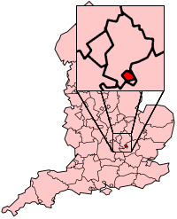
Luton (/ˈluːtən/) is a large town in the east of England, 32 miles (51 kilometres) north of London. Historically, Luton is within the county of Bedfordshire, and since 1997, the town has been a unitary authority. Luton, along with its near neighbours of Dunstable and Houghton Regis, form the Luton/Dunstable Urban Area with a population of over 230,000.[3]
Luton is home to Luton Town Football Club, London Luton Airport, and the University of Bedfordshire. The Luton Carnival, held on the late May bank holiday, is the largest one-day carnival in Europe. The town was for many years famous for hat-making and was also home to a large Vauxhall Motors factory; the head office of Vauxhall Motors is still situated in the town.
Contents |
History
Early history
The earliest settlements in the Luton area were at Round Green and Mixes Hill, where Paleolithic encampments (about 250,000 years old) have been found.[4] Settlements re-appeared after the ice had retreated in the Mesolithic period around 8000 BC. Traces of these settlements have been found in the Leagrave area of the modern town. Remains from the Neolithic period (4500-2500 BC in this area) are much more common. A particular concentration of Neolithic burials has been found at Galley Hill.[5] The most prominent Neolithic structure is Waulud's Bank - a henge dating from around 3000 BC. From the Neolithic onwards, the area seems to have been fairly thickly populated, but without any single large settlement.
The first urban settlement nearby was the small Roman town of Durocobrivis at Dunstable, but Roman remains in Luton itself consist only of scattered farmsteads.[6]
The foundation of Luton is usually dated to the 6th century when a Saxon outpost was founded on the River Lea, Lea tun.[7] Luton is recorded in the Domesday Book as Loitone and also as Lintone.[8] Agriculture dominated the local economy at that time, and the town's population was around 700-800.


In 1121 Robert, 1st Earl of Gloucester started work on St Mary's Church in the centre of the town. The work was completed by 1137.[9] A motte and bailey type castle which gives its name to the modern Castle Street was built in 1139. The castle was demolished in 1154[10] and the site is now home to a Matalan store. During the Middle Ages Luton is recorded as being home to six watermills. Mill Street, in the town centre, takes its name from one of them.
King John (1166-1216) had hired a mercenary soldier, Falkes de Breauté, to act on his behalf. (Breauté is a small town near Le Havre in France.) When he married, Falkes de Breauté acquired his wife's house which came to be known as "Fawkes Hall", subsequently corrupted over the years to "Foxhall", then "Vauxhall". In return for his services, King John granted Falkes the manor of Luton. He was also granted the right to bear his own coat of arms and chose the mythical griffin as his heraldic emblem. The griffin thus became associated with both Vauxhall and Luton in the early 13th century.[11]
By 1240 the town is recorded as Leueton. The town had an annual market for surrounding villages in August each year, and with the growth of the town a second fair was granted each October from 1338.
In 1336, much of Luton was destroyed by a great fire, however the town was soon rebuilt.
The agriculture base of the town changed in the 16th century with a brick making industry developing around Luton, many of the older wooden houses were rebuilt in brick.
17th century
During the English Civil War of the 17th century , in 1645, royalists entered the town and demanded money and goods. Parliamentary forces arrived and during the fighting four royalist soldiers were killed and a further twenty-two were captured. A second skirmish occurred three years later in 1648 when a royalist army passed through Luton. A number of royalists were attacked by parliamentary soldiers at an inn on the corner of the current Bridge Street. Most of the royalists escaped but nine were killed.
18th century
The hat making industry began in the 17th century and became synonymous with the town.[12] By the 18th century the industry dominated the town. Hats are still produced in the town on a much smaller scale.
Luton Hoo, a nearby large country house was built in 1767 and substantially rebuilt after a fire in 1843. It is now a luxury hotel.[13]
19th century

The town grew strongly in the 19th century. In 1801 the population was 3,095.[14] By 1850 it was over 10,000 and by 1901 it was almost 39,000. Such rapid growth demanded a railway connection but the town had to wait a long time for one. The London and Birmingham Railway (L&BR) had been built through Tring in 1838, and the Great Northern Railway was built through Hitchin in 1852, both bypassing Luton, the largest town in the area. A branch line connecting with the L&BR at Leighton Buzzard was proposed, but because of objections to release of land, construction terminated at Dunstable in 1848. It was another ten years before the branch was extended to Bute Street Station, and the first train to Dunstable ran on 3rd May, 1858.[15] The line was later extended to Welwyn and from 1860 direct trains to King's Cross ran. The Midland Railway was extended from Bedford to St Pancras through Leagrave and Midland Road station and opened on 9 September 1867.[16]
Luton received a gas supply in 1834. Gas street lights were erected and the first town hall was opened in 1847.
Newspaper printing arrived in the town in 1854. The year the first public cemetery was opened in the same year. Following a cholera epidemic in 1848 Luton formed a water company and had a complete water and sewerage system by the late 1860s. The first covered market was built (the Plait Halls - now demolished) in 1869. Luton was made a borough in 1876.[17] A professional football club - the first in the south of England - was founded in 1885 following a resolution at the Town Hall that a 'Luton Town Club be formed' .[18]
The crest also includes a hand holding a bunch of wheat, either taken as a symbol of the straw-plaiting industry, or from the arms of John Whethamsteade, Abbott of St Albans, who rebuilt the chancel of St Mary's Church in the 15th century.
20th century

In the 20th century, the hat trade severely declined and was replaced by other industries. In 1905, Vauxhall Motors opened the largest car plant in the United Kingdom in Luton. Electrolux built a household appliances plant which was followed by other light engineering businesses.
In 1904 councillors Asher Hucklesby and Edwin Oakley purchased the estate at Wardown Park and donated it to the people of Luton. Hucklesby went on to become Mayor of Luton. The main house in the park became Luton Museum & Art Gallery.
The town had a tram system from 1908 until 1932 and the first cinema was opened in 1909. By 1914 the population had reached 50,000.
The original town hall was destroyed in 1919 during Peace Day celebrations at the end of World War I. Local people including many ex-servicemen were unhappy with unemployment and had been refused the use of a local park to hold celebratory events. They stormed the town hall setting it alight (see Luton Town Hall). A replacement building was completed in 1936. London Luton Airport opened in 1938, owned and operated by the council.

In World War II, the Vauxhall Factory built Churchill tanks[19] as part of the war effort. Despite heavy camouflage, the factory made Luton a target for the Luftwaffe and the town suffered a number of air raids. Although only 107 people died[20] there was extensive damage to the town and over 1,500 homes were damaged or destroyed. Other industry in the town, such as SKF which produced ball bearings, made a vital contribution to the war effort. Although a bomb landed at the SKF Factory[21] no major damage was inflicted. Post-war, the slum clearance continued and a number of substantial estates of council housing were built, notably at Farley Hill, Stopsley, Limbury, Marsh Farm and Leagrave (Hockwell Ring). The M1 motorway passed just to the west of the town in 1959. In 1962 a new library (to replace the cramped Carnegie Library) was opened by the Queen in the corner of St George's Square.
In the late 1960s a large part of the town centre was cleared to build a large covered shopping centre, the Arndale Centre, which was opened in 1972.[22], becoming the first shopping mall in Europe. It was refurbished and given a glass roof in the 1990s.

In 2000, Vauxhall announced the end of car production in Luton; the plant closed in March 2002.[23] At its peak it had employed in excess of 30,000 people. Vauxhall's headquarters remain in the town, as does its van and light commercial vehicle factory.
21st century
A major regeneration programme for the town centre is underway, which will include upgrades to the town's bus and train stations as well as general improvements to the town's urban environment. St George's Square has been rebuilt[24] and reopened in 2007. The new design won a Gold Standard Award for the Town Centre Environment from the annual British Council of Shopping Centres awards.[25]
Work is beginning on an extension to the Mall shopping centre facing St Georges Square, The Mall has already let the largest of the new units to TK Maxx. Planning applications for a much larger extension to The Mall Arndale shopping centre (In the Northern gateway area - Bute Stret, Silver Street and Guildford Street) and also for a new centre in Power Court[26] (close to St Marys Church) have been submitted. On the edge of Luton at Putteridge Bury a new high-technology office park, Butterfield Green, is under construction. The former Vauxhall site is also to be re-developed as a mixed use site called Napier Park.[27] It will feature housing, retail and entertainment use, including a new casino.
Governance
The town is situated within the historic county of Bedfordshire, but since 1997 Luton has been an administratively independent unitary authority. The town remains part of Bedfordshire for ceremonial purposes.
Parliamentary representation
Luton is represented by two Members of Parliament. The constituency of Luton North has been held by Kelvin Hopkins (Labour) since 1997. Luton South has been held by Margaret Moran (Labour) also since 1997. Luton is within the East of England (European Parliament constituency).
Local Council
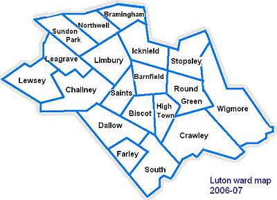
Lutonians are governed by Luton Borough Council. The town is split into 19 wards, represented by 48 councillors. Elections are held for all seats every four years, with the most recent local elections held in May 2007 and the next due in May 2011.
The Council is currently controlled by the Labour group, who have 26 Local Councillors (a majority of 5). The next largest party is the Liberal Democrats with 17 seats, followed by the Conservative Party with 5 seats.
Town Crest
In 1876 the town was granted its own coat of arms. The wheat sheaf was used on the crest to represent agriculture and the supply of wheat straw used in the local hatting industry (the straw-plaiting industry was brought to Luton by a group of Scots under the protection of Sir John Napier of Luton Hoo). The bee is traditionally the emblem of industry and the hive represents the straw-plaiting industry for which Luton was famous. The rose is from the arms of the Napier family, whereas the thistle is a symbol for Scotland. An alternative suggestion is that the rose was a national emblem, and the thistle represents the Marquess of Bute, who formerly owned the Manor of Luton Hoo.[28][29]
Geography and geology

Luton is located in a break in the Eastern part of the Chiltern Hills. The Chilterns themselves are a mixture of chalk from the Cretaceous period[30] (about 65-146 million years ago) and deposits laid at the southernmost points of the ice sheet during the last ice age (the Warden Hills area can be seen from much of the town).
Bedfordshire had a reputation for brick making which has now significantly reduced. The brickworks[31] at Stopsley took advantage of the clay deposits in the east of the town.
The source of the River Lea, part of the Thames Valley drainage basin, is in the Leagrave area of the town. The Great Bramingham Wood surrounds this area. It is classified as ancient woodland; records mention the wood at least 400 years ago.
Opportunities for the town to develop have always been good, since there are few other passes through the hilly area for some miles. This has led to several major roads (including the M1 and the A6) and a major rail-link to be constructed through the town. By way of comparison, the railway by-passed nearby Dunstable, which was once a more prosperous town.
Luton has a temperate marine climate, like much of the British Isles, with regular but generally light precipitation throughout the year. The weather is very changeable from day to day and the warming influence of the Gulf Stream makes the region mild for its latitude. The average total annual rainfall is 584 millimetres (23 in) with rain falling on 109 days of the year.
| Month | Jan | Feb | Mar | Apr | May | Jun | Jul | Aug | Sep | Oct | Nov | Dec | Year |
|---|---|---|---|---|---|---|---|---|---|---|---|---|---|
| Average high °C (°F) | 6.4 (44) |
6.9 (44) |
9.7 (49) |
12.0 (54) |
15.7 (60) |
18.6 (65) |
21.5 (71) |
21.5 (71) |
18.2 (65) |
14.0 (57) |
9.5 (49) |
7.2 (45) |
13.5 (56) |
| Average low °C (°F) | 0.8 (33) |
0.6 (33) |
2.3 (36) |
3.6 (38) |
6.2 (43) |
9.3 (49) |
11.5 (53) |
11.6 (53) |
9.7 (49) |
6.6 (44) |
3.3 (38) |
1.8 (35) |
5.6 (42) |
| Precipitation mm (inches) | 48.4 (1.91) |
36.6 (1.44) |
43.5 (1.71) |
47.2 (1.86) |
45.3 (1.78) |
56.9 (2.24) |
44.7 (1.76) |
48.6 (1.91) |
53.6 (2.11) |
56.8 (2.24) |
49.0 (1.93) |
53.8 (2.12) |
584.4 (23.01) |
| Sunshine Hours | 58.6 | 76.3 | 99.5 | 153.0 | 183.8 | 185.7 | 200.9 | 188.5 | 139.8 | 114.1 | 72.0 | 51.5 | 1,523.6 |
| Source: [32] 2008-06-16 | |||||||||||||
Areas and suburbs
The Victorian expansion of Luton initially focused on areas close to the existing town centre and railways. In the 1920s and 1930s growth typically was though absorbing neighbouring villages and hamlets and infill construction between them and Luton. After the Second World War there were several significant estates and developments constructed both local authority such as Farley Hill or Marsh Farm, or private such as Bushmead.
Former villages and hamlets: Biscot, Crawley Green, Leagrave, Limbury, Round Green, Stopsley
Early expansion of Luton: Bury Park, Dallow, High Town, New Town
New estates: Bramingham, Bushmead, Farley Hill, Hockwell Ring, Lewsey, Marsh Farm, Sundon Park, Warden Hills, Wigmore
Demographics
The United Kingdom Census 2001 showed that Luton had a population of 184,371, a 5.8% increase from the last census meaning that Luton is the 27th[33] largest settlement in the UK. Of this, 43,324 were under 15, 131,660 were between 16 and 74 and 9387 were over 74.[34] The Office for National Statistics mid-year estimate of the 2006 population is 186,800. However, the Luton Borough Council Research and Intelligence Team criticise this figure as understating the recent immigration from Eastern Europe, and they estimate the true figure to be "in the region of 202,500".[35]
| Population since 1801 - Source: A Vision of Britain through Time[36] | |||||||||||||
| Year | 1801 | 1851 | 1901 | 1911 | 1921 | 1931 | 1941 | 1951 | 1961 | 1971 | 1981 | 1991 | 2001 |
|---|---|---|---|---|---|---|---|---|---|---|---|---|---|
| Population Luton | 2,985 | 11,067 | 31,981 | 49,315 | 57,378 | 66,762 | 84,516 | 106,999 | 132,017 | 162,928 | 163,208 | 174,567 | 184,390 |
Local inhabitants are known as Lutonians.
Ethnicity
Luton has seen several waves of immigration. In the early part of the 20th century Irish and Scottish people arrived in the town, these were followed by Afro-Caribbean and Asian immigrants. More recently a new wave of immigrants from Eastern Europe has made Luton their home. As a result of this Luton has a diverse ethnic mix, with a significant population of Asian descent, mainly Pakistani (9.8%), Indian (4.2%) and Bangladeshi (4.3%). The 2005 Office of National Statistics figures revealed that town had a white population of 68% (of which white British amounted to 61.3%) compared to an East of England average of 92.8%.
| Luton: Ethnicity: 2005 Office of National Statistics estimates[37] | |||||||||||||
| Luton % | East of England % | England % | |||||||||||
|---|---|---|---|---|---|---|---|---|---|---|---|---|---|
| White | 68.0 | 92.8 | 89.1 | ||||||||||
| Mixed | 2.8 | 1.4 | 1.6 | ||||||||||
| Asian or Asian British | 19.3 | 3.1 | 5.3 | ||||||||||
| Black or Black British | 7.9 | 1.6 | 2.7 | ||||||||||
| Chinese or Other Ethnic Group | 2.0 | 1.1 | 1.3 | ||||||||||
| Total | 100.0 | 100.0 | 100.0 | ||||||||||
Religion


According to the United Kingdom Census 2001, 60% of the inhabitants in Luton are Christian 15% are Muslim.[38]
The full statistics are as follows[39]
| Religion | Luton % | National % |
|---|---|---|
| Christian | 59.6% | 71.7% |
| Muslim | 14.6% | 3.0% |
| Hindu | 2.7% | 1.1% |
| Sikh | 0.8% | 0.6% |
| Jewish | 0.3% | 0.5% |
| Buddhist | 0.2% | 0.3% |
| Other | 0.3% | 0.3% |
| No religion | 14.1% | 14.8% |
| Religion not stated | 7.2% | 7.7% |
Economic activity
Of the town's working population (classified 16-74 years of age by the Office for National Statistics), 63% are employed. This figure includes students, the self-employed and those who are in part-time employment. 11% are retired, 8% look after the family or take care of the home and 5% are unemployed.[40]
Economy
Luton's economy has, traditionally been focused on several different areas of industry including Car Manufacture, engineering and millinery. However, today, Luton is moving towards a service based economy mainly in the retail and the airport sectors, although there is still a focus on light industry in the town.
Notable firms with offices in Luton include:
- Anritsu - electronics
- AstraZeneca - pharmaceuticals
- Selex Galileo - aerospace
- easyJet - head office (easyLand and Hangar 89) and main base at London Luton Airport
- Ernst & Young - accountants
- Experian - data and analytics
- Monarch Airlines - headquarters, at Luton Airport
- Mazars - accountants
- Siemens AG - electronics
- Thomson Holidays - travel
- Whitbread - hospitality
- Vauxhall Motors - headquarters
Shopping

The main shopping area in Luton is centred around The Mall Arndale. Built in the 1960s/1970s and opened as an Arndale Centre, construction of the shopping centre led to the demolition of a number of the older buildings in the town centre including the Plait Halls (a Victorian covered market building with an iron and glass roof). Shops and businesses in the remaining streets, particularly in the roads around Cheapside and in High Town, have been in decline ever since. George Street, on the south side of the Arndale, was pedestrianised in the 1990s.
Contained within the main shopping centre is the Market, which contains butchers, fishmongers, fruit and veg, hairdressers, sci-fi stores, tattoo parlours, ice cream, flower stall and T-shirt printing as well as eating places including Chinese and Jamaican.
Another major shopping area is Bury Park where there are shops catering to Luton's ethnic minorities.
Food and drink
Luton has a diverse selection of restaurants - English, Italian, Chinese, Indian, Caribbean, Thai and Malaysian to name a few. No area of the town is specifically restaurant-orientated, but in some areas (such as Bury Park) there is a concentration of Asian restaurants.
There are pubs and clubs in the town centre. A number of these cater for the town's student population; however, there are still a number of traditional pubs in the town.
Transport

Luton has excellent transport links and is situated less than 30 miles north of the centre of London, giving it good links with the City and other parts of the country via the motorway network and the National Rail system. Luton is also home to London Luton Airport, one of the major feeder airports for London and the southeast. Luton is also served by a bus service run by Arriva and a large taxi network. As a Unitary Authority, Luton Borough Council is responsible for the local highways and public transport in the Borough and licensing of Taxis.
Air

A council-owned airport was first opened on the current site as Luton Municipal Airport on 16 July 1938[41] by the Secretary of State for Air, Kingsley Wood. During the Second World War Luton Airport was a base for the Royal Air Force 264 Fighter Squadron.[42]
London Luton Airport has expanded rapidly over the last few years.[43] The airport is a hub for budget airlines offering cheap flights. Flights from the airport increased substantially from the 1960s as new charter airlines (e.g. Court Line) flew from there in preference to the London airports. Despite problems in the 1970s, a new terminal was opened in 1985 by the Prince of Wales.[42] The airport was renamed London Luton Airport in 1990, just before Ryanair took its business to Stansted. The growth of new low-cost flights rejuvenated the airport and passenger numbers more than doubled from 1992 to 1998. In 1999, a new terminal was added and a new railway station, Luton Airport Parkway, opened.[42] The airport is managed by a Spanish airport operator on behalf of the council.
The airport is infamous for its inclusion in a 1970s advert for Campari featuring Lorraine Chase.[44] (When asked "Were you truly wafted here from paradise?" she replied "Nah, Luton Airport!")
Luton Airport is also a major base for private jets.
Rail

Luton is served by three railway stations, Luton, Luton Airport Parkway and Leagrave, all on the same line. First Capital Connect's high frequency Thameslink route services run north to Bedford and south to Brighton via several central London stations. East Midlands Mainline 'intercity' services run north to Leicester, Nottingham, Lincoln, Sheffield, Leeds and other cities, and south to London St Pancras International on the Midland Main Line.
Luton and Leagrave stations were built by the Midland Railway in 1868 on its extension to St. Pancras. The old Leagrave Midland station buildings still exist, having been carefully restored in the 1980s. For some years Luton station was known as Luton Midland Road to distinguish it from the earlier Luton Bute Street, built by the Luton, Dunstable and Welwyn Junction Railway Company in 1858, later part of the GNR. Bute Street was closed in 1965.
There are plans to introduce 24-hour rail services to Luton and Luton Airport Parkway.[45] The Thameslink Programme will also provide further rail links to southwards to Guildford, East Grinstead, Ashford, Dartford and the South Coast.[46]
Bus and coach services
Bus services in Luton are provided in the main by the national group Arriva,[47] through their registered company Arriva The Shires Ltd, based in Luton. Other significant local operators include Centrebus [48], and Grant Palmer.[49] Uno operate bus services to the Hatfield campus of the University of Hertfordshire. Stagecoach runs services to Bedford using its Stagecoach in Bedford subsidiary. Stagecoach also operates the Virgin Trains Express Coach service VT99 from Luton Airport and Luton station to Milton Keynes Central. Regional and commuter coach services from Luton are operated by National Express, Marshall's Coaches [50] and Green Line Coaches.
Guided bus link
As part of its Local Transport Plan, Luton Borough Council gained statutory powers in 2005 for construction of a guided bus link between Luton and Houghton Regis and Dunstable.[51] Originally named Translink, the scheme is now known as the Luton to Dunstable Busway.[52]
As the scheme is to use much of right-of-way of the Luton to Dunstable railway, which closed in 1989,[53] it has met with considerable opposition[54] from parties that would rather see the re-instatement of heavy rail services along the branch, or by extending the Thameslink railway line farther afield. Others put forward the view that light rail or trolleybuses were more appropriate for a high-speed link and for linking to a major airport. Supporters pointed out that no funding could be gained for the proposed alternatives, which would leave the link unused, and the guided bus had the advantages of flexibility and accessibility from local areas. In 2000 council publicity material abou Translink triggered a complaint to the Advertising Standards Agency alleging misleading statements, which was partially upheld.[55]
Road

Luton is connected to the major arterial route, the M1 motorway, and the other major roads, the A6 and the A505.
Construction of the first section of the M1 in 1959 resulted in Luton being one of the first towns in the United Kingdom to benefit from the new motorway network. The M1 connects with Luton at Junctions 10 and 11, to the south and west of the town. The M1 provides access to London and the North. The A6 starts in the town and travels north to Bedford and eventually the North West. The A6 previously extended south to Barnet, this section has since been re-numbered as the A1081. The A505 provides an east–west connection through Luton, to Hitchin and further east to the A1(M) or East Anglia; and to Dunstable and the A5 to the west. In Luton, the A505 takes a large diversion forming a southerly ring road around the town, with the A5228 providing a more direct northerly bypass with the A505.
In 2006 work started on widening the M1 past Luton and to the South, and work also started on upgrading the access from the M1 to the Airport, as part of the Local Transport Plan east Luton corridor improvement scheme.[56]
The A5 road which passes through nearby Dunstable is laid on the route of the Watling Street, an ancient route of England.
Education

Luton is home to the University of Bedfordshire. The main campus of the University is in Luton town centre with a further campus based on the edge of town in Putteridge Bury, an old Victorian manor house. The University also owns several buildings in Bedford.
The town is home to Luton Sixth Form College and Barnfield College. Both have been awarded Learning & Skills Beacon Status by the Department for Children, Schools and Families.[57][58]
Luton's schools and colleges have also been earmarked for major investment in the government scheme Building Schools for the Future programme, which intends to renew and refit buildings in institutes across the country. Luton is in the 3rd wave of this long term programme with work intending to start in 2009.[59]
There are 98 educational institutes in Luton - seven Nurseries, 70 Primary schools (9 Voluntary-Aided, 2 Special Requirements), 13 Secondary Schools (1 Voluntary-Aided, 1 Special Requirements), four Further Educational Institutes and four other Educational Institutes.[60]
Culture and leisure
Sport

Luton is the home town of Luton Town Football Club who play in the Coca-Cola Football League Two,[61] the 4th Flight of the English league structure. Their nickname, "The Hatters", dates back to when Luton had a substantial millinery industry.
Speedway racing was staged in Luton in the mid 1930s.
The town has three rugby clubs - Luton RFC play in National 3 South, Vauxhall Motors RFC play in London 3 NW and Stockwood Park play in Midlands 4 SE.
Wardown Park

Wardown Park is situated on the River Lea in Luton. The park has various sporting facilities, is home to the Luton Museum & Art Gallery and contains formal gardens. The park is located between Old Bedford Road and the A6, New Bedford Road and is within walking distance of the town centre.[62]
Stockwood Park

Stockwood Park is a large municipal park near Junction 10 of the M1. The park houses the craft museum, the Mossman Collection and the period formal gardens which are all free of charge for visitors. There is an athletics track, an 18-hole golf course, several rugby pitches and areas of open space.
The park was originally the estate and grounds to Stockwood house, which was demolished in 1964.
Carnival
Luton Carnival is the largest one-day carnival in Europe. It usually takes place on the late May Bank Holiday. With good weather, crowds usually top 150,000[63] on each occasion.
The procession starts at Wardown Park and makes its way down New Bedford Road, around the Town Centre via St George's Square, back down New Bedford Road and finishes back at Wardown Park. The procession is complemented by music stages and stalls around the town centre and at Wardown Park.
St. Patrick's Day
The local annual festival celebrating the Patron saint of Ireland, St Patrick, is held on the weekend nearest to March 17 and is attended by more than 3,000 people [64]. Now on its 9th year [65], the festival brings the strong Irish culture in Luton to everyone and includes a parade, various markets stalls and music stands as well as Irish themed events happening across various places in Luton. [66]
Theatre
Luton is home to "The Library Theatre", a 238 seat theatre located on the 3rd floor of the town's Central Library. The Theatre's core programme consists of local amateur dramatic societies, pantomime, children's theatre (on Saturday mornings) and one night shows of touring theatre companies. [67]
Museums
Luton Museum
Luton Museum & Art Gallery in Luton is housed in a large Victorian mansion in Wardown Park on the outskirts of the town centre. The museum collection focusses on the traditional crafts of Bedfordshire, notably lace-making and hat-making. There are samples of local lace from as early as the 17th century.
The Wenlock Jug, a rare example of a jug cast, was almost sold to New York’s Metropolitan Museum of Art for £750,000 but was export-stopped in October 2005 by culture minister, David Lammy, based on a recommendation by the Reviewing Committee on the Export of Works of Art and Objects of Cultural Interest, run by the Museums, Libraries and Archives Council.
Stockwood Craft Museum
Based in Stockwood Park, Luton, the collection of rural crafts and trades held at Stockwood Park Museum was amassed by Thomas Wyatt Bagshawe, who was a notable local historian and a leading authority on folk life. Bagshawe was born in Dunstable in 1901 and became a director of the family engineering firm.

The collection only contains examples from Bedfordshire and the borders of neighbouring counties, giving the collection a very strong regional identity.
Mossman Collection
The Mossman Carriage collection is held at Stockwood Park, Luton and is the largest and most significant vehicle collection of its kind in the country, including originals from the 18th, 19th and 20th centuries.
The Mossman collection of horse drawn vehicles was given to Luton Museum Service in 1991. It illustrates the development of horse-drawn road transportation in Britain from Roman times up until the 1930s.
Local attractions
| Key | |
| Abbey/Priory/Cathedral | |
| Accessible open space | |
| Amusement/Theme Park | |
| Castle | |
| Country Park | |
| English Heritage | |
| Forestry Commission | |
| Heritage railway | |
| Historic House | |
| Museum (free/not free) | |
| National Trust | |
| Zoo | |
|
Twin towns
Luton participates in international town twinning; its partners[68] are:
| Country | Place | County / District / Region / State | Date | |||
|---|---|---|---|---|---|---|
| Germany | Bergisch Gladbach | North Rhine-Westphalia | 1956 | |||
| France | Bourgoin-Jallieu | Rhône-Alpes | 1956 | |||
| Sweden | Eskilstuna | Södermanland | 1949 | |||
| Germany | Berlin-Spandau | Berlin | 1959 | |||
| Germany | Wolfsburg | Lower Saxony | 1950 |
Notable Lutonians
People who are Luton-born or are strongly associated with the town.
|
|
|
Media
Newspapers
Two weekly newspapers are delivered free to all the houses in Luton. They are:
The Herald and Post has a sister paper which is not free.
- Luton News,[71] published every Wednesday
The local council produces a monthly newspaper, LutonLine,[72] usually delivered with the Luton on Sunday.
Radio
The local BBC station, BBC Three Counties Radio broadcasts from its office in Hastings Street, Luton to Bedfordshire, Hertfordshire and Buckinghamshire.[73]
Chiltern Radio is the local independent station and broadcasts from Chiltern Road in Dunstable.
The university's radio station, Luton FM, runs for 28 days during May. In addition, Ramadan FM broadcasts during the month of Ramadan. Diverse FM[74] began broadcasts in April 2007 having been awarded a community radio license from Ofcom.
Television
Local-News TV is a local news channel for Bedfordshire and Luton. The channel is broadcast solely over the internet with content available on-demand.
Media references
In the TV series One Foot in the Grave there are often references to places within Luton. The script-writer David Renwick was brought up in the town.
The town was mentioned several times in the seminal sketch show Monty Python's Flying Circus. In one sketch a rather half-hearted hijacker demands that a plane headed for Cuba be diverted to Luton. Luton is one of the constituencies returning a "Silly Party" victory in the famous sketch Election Night Special. In the Piranha Brothers sketch Spiny Norman lived in a hangar at Luton Airport. A 1976 episode of the sci-fi series "Space: 1999" was called the The Rules of Luton, inspired by the town name.
References
- ↑ Leadership=Mayor & Cabinet
Executive=Labour - ↑ Luton Borough Council estimate for 2006. See the Demographics section above for further information.
- ↑ "Local Transport Plan: The Luton, Dunstable and Houghton Regis Conurbation" (PDF). Retrieved on 2008-06-16.
- ↑ Dyer J, Stygall F, Dony J, The Story of Luton, Luton, 1964, p 20
- ↑ Dyer ibid, p 23
- ↑ Dyer ibid, p 31
- ↑ "Early history of Luton". Retrieved on 2008-06-16.
- ↑ "Doomsday book record". Retrieved on 2008-06-16.
- ↑ "History of St Mary's Church". Retrieved on 2008-06-16.
- ↑ "Luton Castle only lasted 15 years". Retrieved on 2008-06-16.
- ↑ "Vauxhall history". Retrieved on 2008-06-16.
- ↑ "A history hat making in Luton". Plaiting and Straw Hat Making. Luton Libraries. Retrieved on 2008-06-18.
- ↑ "Website of Luton Hoo Hotel Golf and Spa". Retrieved on 2008-06-18.
- ↑ "Population figures for 1801, 1901 and 1901". Retrieved on 2008-06-16.
- ↑ Dyer, ibid, p 141
- ↑ Dyer, ibid, p 142
- ↑ "Luton was made a borough". Retrieved on 2008-06-16.
- ↑ "Formation of Luton Town". Retrieved on 2008-06-16.
- ↑ Churchill Tanks at Vauxhall
- ↑ Deaths during WWII
- ↑ See book Luton at War volume II,compiled by The Luton News, 2001, ISBN 1-871199-49-2
- ↑ tant-car-hire.co.uk/england/luton.html Arndale opened in 1972
- ↑ Vauxhall closure
- ↑ St Georges Square on Luton Council Site
- ↑ Award won by St Georges Square
- ↑ Website for the development of Power Court
- ↑ "Napier Park website". Retrieved on 2008-06-18.
- ↑ "Luton Town Crest". Retrieved on 2008-06-18.
- ↑ "Arms of Luton (England)". Retrieved on 2008-06-18.
- ↑ Map of soil distribution in Beds
- ↑ ISBN 1-871199-94-8
- ↑ "Bedford 1971-2000 averages" (in English). Met Office. Retrieved on 16 June, 2008.
- ↑ KS01 Usual resident population: Census 2001, Key Statistics for urban areas
- ↑ 2001 Census
- ↑ "Statistical Issues Relating to the ONS Population Estimates of Luton(PDF), page 32" (PDF). Luton Borough Council Research and Intelligence Team. Retrieved on 2008-06-16.
- ↑ "Luton: Total Population". A Vision of Britain Through Time. Great Britain Historical GIS Project. Retrieved on 2008-06-16.
- ↑ "Ethnic groups % - 2005 estimates". Office of National Statistics. Retrieved on 2008-06-16.
- ↑ "Religion breakdown". National Statistics Office. Retrieved on 2008-06-16.
- ↑ "National Statistics". Retrieved on 2008-06-16.
- ↑ "Employment statistics". National Office of Statistics. Retrieved on 2008-06-16.
- ↑ "Luton Airport Opening". Retrieved on 2008-06-16.
- ↑ 42.0 42.1 42.2 "History Luton Airport History". Luton Airport Website. Retrieved on 2008-06-16.
- ↑ "Luton Airport - fastest growing in the UK". Retrieved on 2008-06-16.
- ↑ "Details of Lorraine Chase advert". Retrieved on 2008-06-16.
- ↑ First Capital plans
- ↑ Network Rail (2006-10-18). "Map of expanded Thameslink route". Retrieved on 2006-11-28.
- ↑ "Passenger services" (PDF). Retrieved on 2008-06-16.
- ↑ "Centre Bus". Retrieved on 2008-06-16.
- ↑ "Grant Palmer". Retrieved on 2008-06-16.
- ↑ "Marshalls Coaches". Retrieved on 2008-06-16.
- ↑ Department for Transport, Luton Dunstable Translink Decision Letter
- ↑ Luton Council busway news release
- ↑ Faber Maunsell environmental impact study of the Translink proposal
- ↑ Department for Transport Luton Dunstable Translink Inspectors' Report Section 5
- ↑ Department for Transport Luton Dunstable Translink Inspectors' Report Section 6.8.2
- ↑ Widening of the M1
- ↑ Barnfield Newsletter
- ↑ "Luton Sixth Form College". Retrieved on 2008-06-16.
- ↑ "L2G Building for the Future Programme details". Retrieved on 2008-06-19.
- ↑ "LEA School List". Luton Borough Council. Retrieved on 2008-06-16.
- ↑ "Luton Town homepage". Retrieved on 2008-06-16.
- ↑ "Luton Council website". Retrieved on 2008-06-16.
- ↑ "Luton Carnival Coverage on the BBC". Retrieved on 2008-06-16.
- ↑ BBC - Beds Herts and Bucks - Why Don't You - Luton's turning green!
- ↑ St patrick's festival
- ↑ St Patrick's Day party is coming to Luton - Luton Today
- ↑ "Shout Luton Theatre Guide". Retrieved on 2008-06-16.
- ↑ "Town twinning". Luton Borough Council. Retrieved on 2008-06-16.
- ↑ "Herald and Post". Retrieved on 2008-06-16.
- ↑ "Luton on Sunday". Retrieved on 2008-06-16.
- ↑ "Luton News". Retrieved on 2008-06-16.
- ↑ "Lutonline homepage". Retrieved on 2008-06-16.
- ↑ "Three Counties Radio". Retrieved on 2008-06-16.
- ↑ "Diverse FM". Retrieved on 2008-06-16.
External links
|
|||||||||||
|
|||||||

|
|||||
|
|||||