Ludwigshafen
| Ludwigshafen am Rhein | |
 |
|
| Coat of arms | Location |
 |
 |
| Administration | |
| Country | Germany |
|---|---|
| State | Rhineland-Palatinate |
| District | Urban district |
| City subdivisions | 10 districts |
| Lord Mayor | Eva Lohse (CDU) |
| Basic statistics | |
| Area | 77.68 km² (30 sq mi) |
| Elevation | 96 m (315 ft) |
| Population | 163,560 (30/12/2006) |
| - Density | 2,106 /km² (5,453 /sq mi) |
| Other information | |
| Time zone | CET/CEST (UTC+1/+2) |
| Licence plate | LU |
| Postal codes | 67059 - 67071 |
| Area codes | 0621, 06237 |
| Website | www.ludwigshafen.de |
Ludwigshafen am Rhein is a city in Rhineland-Palatinate, Germany. Ludwigshafen is located on the Rhine opposite Mannheim. Together with Mannheim, Heidelberg and the surrounding region, it forms the Rhine Neckar Area.
Ludwigshafen is known for its chemical industry (BASF). Among its cultural facilities rank the Staatsphilharmonie Rheinland-Pfalz. Ludwigshafen is the birthplace of the former German chancellor Helmut Kohl, the philosopher Ernst Bloch.
Contents |
History
Early History
In antiquity, Celtic and Germanic tribes settled here and during the last century B.C., the Romans conquered the region and a Roman auxiliary fort was constructed near the present suburb of Rheingönheim.
In the Middle Ages, some of the later suburbs of Ludwigshafen were founded, for example Oggersheim, Maudach, Oppau and Mundenheim, but most of the area was still swampland.
The Rheinschanze

All the region belonged to the territory of the Prince-elector of the Kurpfalz, or Electoral Palatinate, one of the larger states within the Holy Roman Empire, and the foundation of the new capital of the Kurpfalz, Mannheim, had decisive influence on the further development of the area on the opposite bank of the Rhine. Parallel to the foundation of Mannheim in 1606, a fortress (die Rheinschanze) was built by Frederick IV, Elector Palatine, on the other side of the River Rhine to protect the City of Mannheim, thus forming the nucleus of the city of Ludwigshafen itself.
But the region had a hard time in the 17th century, it was devastated and depopulated during the Thirty Years' War and also in King Louis XIV of France´s wars of conquest in the later part of the century.
It was only in the 18th century that the settlements around the Rheinschanze began to prosper and they profited from the proximity of the capital Mannheim. Especially Oggersheim gained some importance: There was a small palace serving as secondary residence for the Elector, the famous pilgrimage church Wallfahrtskirche was built and for some weeks in 1782, even the great German writer and playwright Friedrich Schiller lived in Oggersheim (admittedly, he was on flight from his native Württemberg).
War came back to the Ludwigshafen area with the armies of the French Revolution. The palace at Oggersheim was burned down, Mannheim besieged several times and all the area left of the Rhine was annexed by France from 1798 to 1813. The Kurpfalz was split up, the eastern bank of the Rhine with Mannheim and Heidelberg was given to Baden, the western bank (including the Ludwigshafen area) was granted to Bavaria after the Wars of Liberation 1813-1815, in which the French were expelled. So the Rhine had become a frontier and the Rheinschanze was cut off politically from Mannheim and lost its function as the neighbouring city's military bulwark.
Foundation of Ludwigshafen
Already in 1808, during the French occupation, Carl Hornig from Mannheim had purchased the fortress from the French authorities and turned it into a resting place for French sailors that needed to pass from that area of the Rhine River. Later, the Rheinschanze with its winter-proof harbour basin (created by a flood in 1824) was used as trading post. Hornig died in 1819, but Johann Heinrich Scharpff, the businessman from Speyer, continued Hornig's plans, which were then turned over to his son-in-law, Philipp Markus Lichtenberger, in 1830. Their activities marked the beginning of the civilian use of the Rheinschanze.
The year 1843 was the official birth of Ludwigshafen, when Lichtenberger sold this property to the state of Bavaria (Bayern), and the military title of the fortress was finally removed. The Bavarian king, Ludwig I, set forth plans to rename the settlement after himself and to start construction of an urban area as a Bavarian rival to Mannheim on the opposite bank.
During the failed German revolution of 1848, rebels took young Ludwigshafen, but they were bombarded from Mannheim (rumours said the Mannheimers didn't aim at the revolutionaries, but on the rival harbour's infrastructure) and Prussian troops quickly expelled the revolutionaries. On December 27, 1852, King Maximilian II granted Ludwigshafen am Rhein political freedom and as soon as November 8, 1859, the settlement gained town status.
Industry and growth of population

But this “town” was still a very modest settlement with just 1.500 inhabitants. The real growth began with industrialization, which gained enormous momentum in Ludwigshafen because of its ideal transport facilities: The perfect Rhine harbour has already been mentioned and in 1849 the railway connecting Ludwigshafen with the Saar coalfields was finished.
The year 1865 was an important date in the history of independent Ludwigshafen. After several discussions, BASF decided to move its factories from Mannheim to the Hemshof district, which belonged to Ludwigshafen. From now on, the city's rapid growth and wealth was linked to the BASF's success and the company's expansion to one of the world's most important chemical companies. With more jobs available, the population of Ludwigshafen started to increase very rapidly, so that in 1899 the city was governing more than 62,000 residents (Compared to 1,500 in 1852).
This rapid population explosion looked quite “American” to contemporaries, it determined Ludwigshafen's character as a “worker's town” and created problematic shortages of housing and real estates. The solution was the expansion of the municipal area and the incorporation of the two nearest villages, Friesenheim and Mundenheim, in the years 1892 and 1899. In the area between the town centre and those two suburbs new quarters (“North” and “South”) were built after (then) modern urban development plans. Because the ground was marshy and too low to be protected from Rhine floods, all the new houses were built on raised ground, sometimes as high as 5 meters above the original ground. You can see the original ground level in many backyards of Ludwigshafen, which are sometimes two floors below street level.
|
World War I and Inter-War Years
When World War I broke out in 1914, Ludwigshafen's industry plants played a key role in Germany's war economy. Many chemical ingredients of explosives and gunpowder for the forces, as well as much of the gas used on the Western Front, were fabricated in Ludwigshafen. This contributed to the fact that, on May 27, 1915, Ludwigshafen had the dubious honour of being the world's first civilian settlement behind the lines to be bombed by air. French aircraft attacked the BASF plants, thereby killing twelve people and setting a precedent for the years to come.
When the war was lost for Germany in 1918, the left bank of the Rhine was occupied by French troops, according to the peace terms. The French occupation lasted until 1930, and some of Ludwigshafen's most elegant houses were erected for the officers of the French garrison.
The economic recovery during the 1920s was thrown back by the worst explosion ever in a German industrial complex when, in 1921, a BASF factory blew up, killing more than 500, injuring a further 2000 and destroying countless buildings.
Nevertheless, Ludwigshafen reached the population number of 100,000 in 1922, thus gaining “City” status and it prospered until the worldwide economic crisis of 1929 caused unemployment, trouble and the final rise of the Nazis.
Initially, the Nazi party had few followers and votes in working-class-dominated Ludwigshafen. But after 1933, when they had come to power in Germany, the Nazis succeeded in getting their ideas through in Ludwigshafen. The Ludwigshafen synagogue was destroyed in 1938 and its Jewish population deported in 1940.
But the Nazis also interfered with Ludwigshafen's development as city. According to their ideology, many small houses with gardens were built, especially in the Gartenstadt. Further, similar to Nazi plans in other Cities (e.g. Hamburg), they aimed at creating a ”Greater Ludwigshafen” by assimilating smaller towns and villages in the vicinity. Thus Oggersheim, Oppau, Edigheim, Rheingönheim and Maudach became suburbs of Ludwigshafen and raised its population number to 135,000.
World War II
During World War II, the city was a prime target for strategic bombing because its two giant I.G. Farben plants, the BASF, covering 1,200 acres (4.9 km2) and employing 40,000 workers, produced much of Germany's ammonia, synthetic rubber, synthetic oil and other vital chemicals. The city's railroad yards were important targets too, and hundreds of small shops and factories produced war materials, such as diesel engines for submarines. Because the junction of Rhine and Neckar at Mannheim was easy to find due to the shimmering waters; blackout was ineffective in Mannheim and Ludwigshafen; Allied bombers had few problems in finding the place by night.
The Luftwaffe ringed the city with 180 high-powered flak guns. Thirteen thousand Allied bombers hit the city in 121 separate raids during the war, of which 56 succeeded in hitting the BASF. Those 56 raids dropped 53,000 bombs each containing 250 to 4,000 pounds of high explosives, plus 2.5 million 4-pound magnesium incendiary bombs. (The bombers also dropped millions of warning leaflets ordering civilians to leave town immediately; they also dropped counterfeit ration coupons.) Clouds (or protective smoke) usually covered the target, so "pathfinder" planes identified the general vicinity with flares, and the bombardiers unloaded on the flares. This sort of "area bombing" was not especially accurate: out of 1,700 bombs dropped on January 7, 1944, only 127 hit the Farben plant. On average, 1.4 tons of bombs hit each acre of the Farben complex (but buildings covered only 25% of the ground, so most hit open land.) Bombing accuracy improved with experience; in a January 1945 raid, 1,000 high explosive bombs and 10,000 incendiaries fell within the factory fences, starting 10 large, 30 medium and 200 small fires. Bombs that missed the factory that day ruined 354 residences and dehoused 1,800 people.
The shelter system worked well, for only five people on the ground were killed. By war's end most dwellings were destroyed or damaged; 1,800 people had died, and 3,000 were injured. Local Nazi officials assisted the homeless and tried to incite the residents to hate the Allies. Most residents were fatalistic or passive, and were instead inclined to blame Berlin for their troubles. Thousands fled to villages or farms, but enough stayed behind to keep producing chemicals and to assist troop transports moving by rail to the battle of the Bulge. When draft calls removed German men, I. G. Farben replaced them with German women, with civilian "volunteers" from France or Italy, and with Polish and Russian prisoners. The foreigners worked to avoid death from starvation; the Nazis treated them brutally, and were negligent about their safety during the air raids. Systematic air attacks began in earnest in early 1944, and reduced production by half that year. Repairs took longer and longer, as spare parts were difficult to find. By December, so much damage had been done to vital utilities that output dropped to nearly zero. Followup raids every week ended production permanently. On March 1, 1945, infantry from Alexander Patch's Seventh Army ended Ludwigshaven's agony by seizing the city and liberating the slave laborers.
With more than 50% of its houses destroyed, Ludwigshafen was one of the most thoroughly bombed cities in Germany.
Postwar rebuilding
As it had been after World War I, Ludwigshafen was occupied by the French. As part of the French occupation zone, it became part of the newly founded Bundesland (state) of Rheinland-Pfalz and thus part of the Federal Republic of Germany. Reconstruction of the devastated city and revival of the economy was supported by the Allies, especially by American aid. In 1948, the “Pasadena Shares Committee” sent packages of blankets, clothing, food, and medicines to help the residents of post-war Ludwigshafen. Many friendships started to form, so that in 1956, Ludwigshafen am Rhein and Pasadena, California became sister cities.
Large parts of the city were literally ruined, but because the BASF soon made enormous profits again, the city administration was wealthy enough to rebuild Ludwigshafen according to the architectural taste of the 1950s and 1960s. The most important projects were the Hochstraßen (highways on stilts), today a ramshackle and torn-down piece of concrete, the revolutionary new main station (then the most modern station in Europe), today almost closed and not connected with important railway traffic, several tower blocks and a whole new suburb that became a focus point of social problems, the satellite quarter Pfingstweide north of Edigheim.
The city's trade tax profits also allowed a lot of social benefits and institutions to be introduced that are closed today. Many other cities were jealous of Ludwigshafen's wealth and the population number reached its all-time climax in 1970 with more than 180,000 inhabitants, thus surpassing even the capital of Rheinland-Pfalz, Mainz, for a while. Today cities point with the fingers to Ludwigshafen and are happy not be in their financial situation, have this kind of architecture, pollution and social problems.
Financial crisis
In the early 1970s, a plan to reform the composition of the German Bundesländer, which could have created a new state around a united Mannheim-Ludwigshafen as capital with more than half a million inhabitants, failed.
Nevertheless, further ambitious projects were financed in Ludwigshafen, first of all the 15-floor city hall with its linked-up shopping centre (Rathaus Center). The last (up to now) new incorporated suburb was Ruchheim in 1974.
But then a process began that accelerated during the 1980s and 1990s and caused the financial near-collapse of Ludwigshafen. The enormous maintenance costs of the buildings and institutions introduced during the “fat time”, new tax regulations that cut down the trade tax profits from the local industries, and thousands of dismissals in BASF were the main causes for the city's crisis. Loss of population due to the loss of working places and general economic trends, such as the oil crises, further worsened Ludwigshafen's financial situation at the end of the 20th century.
The negative aspects of industrial success became obvious when examinations revealed the bad state of air and the Rhine due to pollution. There had always been some stench or dirt all over the city, caused by BASF and other plants, and as long as the industry had prospered, people had accepted it. Besides that, the concrete constructions that had been so modern after the war and had a formative influence on today's townscape, were increasingly considered as obsolete and even as extremely ugly. The main station was rotting as a rarely used concrete monstrum.
Contemporary Ludwigshafen
In recent years, many efforts have been made to enhance Ludwigshafen's image in the media. The city administration has cut down its deficit by cutting down social payments and maintenance, pollution has been (not least by BASF) restricted, the formerly rotten Hemshof quarter has been restored.
One of the most annoying faults of Ludwigshafen – at least for many of the city's inhabitants - is its comparative lack of high-quality shopping possibilities. It has been attempted to repair this deficiency by creating a second large shopping mall on the southern tip of the city centre (the Walzmühle near Berliner Platz) with affiliated railway station (Ludwigshafen-Mitte) - but it didn't turn out as planned. Hopes are now pinned on the construction of another shopping mall on the banks of the Rhine.
For all its real and alleged shortcomings, Ludwigshafen still has enormous importance as industrial city.
Districts
Center
The city center of Ludwigshafen is comparatively small and dominated by post-war buildings. Its northern and southern boundaries are the Hochstraßen (highways on stilts), the Rhine is in the East and the main station is located in the West of downtown Ludwigshafen, at a walking distance of about 15 minutes from the central pedestrian precinct Bismarckstraße that forms, together with the shopping mile Ludwigsstraße, the main North-South Axis, connecting the so-called “North Pole” with the Rathaus Center and the “South Pole” with Berliner Platz and Walzmühle. The main East-West connections are the Bahnhofsstraße and Kaiser-Wilhelm-Straße. The Pfalzbau, Staatsphilharmonie, Wilhelm-Hack-Museum and the half-destroyed monument Lutherkirche are main features of downtown Ludwigshafen.
South
The Südliche Innenstadt or “southern city centre” (ca. 29,000 inhabitants) includes the real city center as described above and the Stadtteil Süd or “South” quarter. “South” belongs to the most attractive residential areas, especially the Parkinsel area. Other sub-quarters of “South” are the Musikantenviertel or the Malerviertel. In a few years, there will be one more high prised residential area (“Rheinufer Süd”) on the River Rhine near the Walzmühle on former industrial estates.
North
The Nördliche Innenstadt (ca. 22,000 inhabitants) includes the Hemshof, “North” and “West” districts. Hemshof and “North” represent the “old town” of Ludwigshafen, they are known for their very high proportion of foreign inhabitants, making them culturally diverse and “colourful” (or better said head-cloth-ful), but also somewhat socially problematic. ”West” (also called Valentin-Bauer-Siedlung) is located between main station and main cemetery.
Friesenheim
Friesenheim (ca. 18,000 inhabitants) is located north of Hemshof and is one of the two (the other one being Mundenheim) “mother villages” of Ludwigshafen, because they were responsible for the administration of Ludwigshafen prior to its independence. Helmut Kohl was born in Friesenheim. Its western district, the Froschlache, boasts four impressive tower blocks.
Oppau
Oppau (ca. 10,000 inhabitants) in the North is dominated by the nearby BASF and had once been a town for its own, prior to its incorporation into Ludwigshafen. In its history, it has been afflicted by several catastrophes like the explosion of 1921 or the flood of 1882.
Edigheim
Edigheim (ca. 9,000 inhabitants) had once been a part of Oppau in the South, today ist almost as large as Oppau.
The Pfingstweide (ca. 6,000 inhabitants) is Ludwigshafen's northernmost district, it is dominated by tower blocks and is located in close vicinity to Frankenthal.
Gartenstadt
The Gartenstadt (ca. 18,000 inhabitants), west of Mundenheim, is (as the name “garden city” suggests) a very green suburb, dominated by flat roofed houses and some tower blocks. Most parts of it are widely known as problem area. Its sub-districts are Niederfeld, Hochfeld and Ernst-Reuter-Siedlung.
Mundenheim
Mundenheim (ca. 13,000 inhabitants) is a very old suburb, it boasts its own railway station, an extensive industrial area near the harbour basins, junkyards and scrap metal retailers. A sub-district is the Herderviertel in Mundenheim's North.
Oggersheim
Oggersheim (ca. 23,000 inhabitants) is one of the most important suburbs, being much like a town for itself (which it was in the Middle Ages). Helmut Kohl owns a bungalow in southern Oggersheim. The Wallfahrtskirche, a railway station, the important Unfallklinik (“accident hospital”), and several large residential blocks are to be found in Oggersheim. For the last few years, the northern subdistricts of Notwende and Melm have seen a large amount of building activities in their new housing estates.
Rheingönheim
Rheingönheim (ca 7,000 inhabitants), as the southernmost suburb of Ludwigshafen, is known mainly for its industry (Woellner) and its game enclosure Wildpark.
Maudach
Maudach (ca. 7,000 inhabitants), in Ludwigshafen's South-West, is a popular residential area, closely associated with the Maudacher Bruch park.
Ruchheim
Ruchheim (ca. 6,000 inhabitants), as the westernmost suburb, has long been a small agricultural village, but now it is growing rapidly due to new housing estates.
Transport


Although Ludwigshafen itself has no airfield, it is well connected with several airports in the region. There are small airfields near Speyer, Bad Dürkheim and Worms, a medium-sized regional airport in Mannheim and the Frankfurt International Airport in about an hour driving distance.
Ludwigshafen is the most important German harbour left of the Rhine. The local industry depends on shipping their raw materials and products on the river. The harbour of Ludwigshafen consists of several basins in the South of the city near Mundenheim (Luitpoldhafen, Kaiserwörthhafen, Mundenheimer Altrheinhafen), the wharfs along the river parallel to the city centre and the BASF, and, finally, of the Landeshafen basin in the North that connects the BASF.
Ludwigshafen has excellent Autobahn (motorway/highway) connections to all directions. Most important are the A 650 in West-East direction, the A 61 in North-South direction. But there are also A 6, A 65 and B 9 to be mentioned.
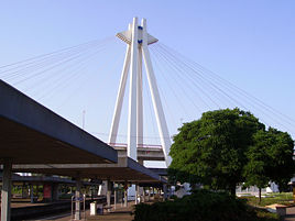
Ludwigshafen has a huge main station, its impressive pylon bridge pier serving as the city's landmark, it is rarely used. The extraordinary architecture of the station complex is caused by the need to connect three joining tracks (to Frankenthal/Worms/Mainz, to Neustadt/Speyer and to Mannheim) and to work in the underground Straßenbahn station and the massive road bridge above the concourse. Other railway stations are at Oggersheim, Mundenheim, Rheingönheim, and, of late, near Berliner Platz. Since 2003, the S-Bahn Rhein-Neckar suburban train system runs successfully in the region.
Ludwigshafen's public transport system is run by the VBL (Verkehrsbetriebe Ludwigshafen) and the holding companies RNV and VRN. The Straßenbahn (tram/streetcar) network is closely connected with Mannheim, three lines (3,4,6) cross the Rhine bridges between the two cities and a further two lines (10,12) run through Ludwigshafen only. In addition, there is Line 14 (also known as "Rhein-Haardt-Bahn"). It's a long-distance tram, which runs from Bad Dürkheim to Ludwigshafen and Mannheim. The bus network consists of about ten municipal lines and further regional lines.
A rather strange feature of Ludwigshafen's public transport system is the existence of five underground stations for the Straßenbahn (Rathaus, Danziger Platz, Hauptbahnhof, Heinrich-Pesch-Haus, Hemshofstraße). They go back to the 1970s, when a common underground network in Mannheim and Ludwigshafen was planned. The rash construction of these first stations in Ludwigshafen became superfluos when Mannheim cancelled the project due to its enormous costs.
Another low point of architecture is the extensive presence of roads running on bridges through the city centre.
Region and neighbours
The twin cities of Mannheim and Ludwigshafen closely cooperate in many areas; although they are separated by the Baden-Württemberg/Rhineland Palatinate boundary, this frontier is mainly an administrative one. Of course there is some rivalry between “LU” and “MA”, but it is restricted mostly to Mannheimers´ jokes about Ludwigshafen's apparent ugliness and Ludwigshafeners´ gloating jokes about the BASF's fumes being blown by the prevailing western winds to Mannheim. Nevertheless, most of the Ludwigshafeners prefer shopping and going out in Mannheim's inner city cause it is far more attractive and within easy reach. In the reverse case, some Mannheimers work in Ludwigshafen and many University of Mannheim students choose Ludwigshafen as residence because of its cheaper rents.
The surroundings of Ludwigshafen on the left bank of the Rhine are called Pfalz and are the easternmost part of the Palatinate region. The administrative district around Ludwigshafen is called Rhein-Pfalz-Kreis. North of Ludwigshafen, there is the industrial town of Frankenthal. In the western vicinity of Ludwigshafen, there are several villages producing enormous amounts of vegetables, thus securing the Rheinpfalz the title of “Germany's vegetable garden”. The district south of Ludwigshafen is dominated by the Rhine and the Altrhein arms (lakes marking the earlier course of the river) and the ancient town of Speyer with its magnificent imperial cathedral, a noteworthy and remarkable city, a huge contrast to Ludwigshafen.
The regions with some more distance to Ludwigshafen include the beautiful German Wine Route region with Germany's biggest coherent winegrowing area and the Palatinate forest, the biggest coherent forest of Europe 50 km in the West, the French region Alsace and the German Schwarzwald (Black Forest) hills in the South, Heidelberg and the Odenwald hills in the East and the Rhein-Main region with the city of Frankfurt about 100km in the North.
Culture
The Pfalzbau as a theatre and concert hall has regional importance, the Staatsphilharmonie Rheinland-Pfalz keeps its own symphonic orchestra. In the Hemshof district, there are smaller theatres playing regional dialect plays.
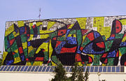
The Wilhelm-Hack-Museum is known for its Miro wall that is getting more and more filthy due to the city smog. Several small museums in Ludwigshafen concentrate on the very short city's history, first of all the Stadtmuseum in the Rathaus Center, but also the Schillerhaus Oggersheim, K.O. Braun-Museum in Oppau or the Frankenthaler Kanal Museum in the North. The Fachhochschule Ludwigshafen (technical college) is specialised on economics and has an affiliated Ostasieninstitut (East Asia Institute). There is also the Evangelische Fachhochschule Ludwigshafen, specialised on social sciences.
Economy
Although the BASF is, of course, by far the most important industrial company in Ludwigshafen, there are many other firms. Trade and industry in Ludwigshafen have about 90,000 employees in total, with an annual total turnover of nearly 17 billion euros.
The BASF is the world's leading chemical company, employing 80,000 people at all and about 35,000 (a few years ago, the employee total was about 55,000) of them in the Ludwigshafen plant, which is also the largest chemical plant in the world. The company's main products are fertilizers, dye, coolants and many other chemical substances. The BASF is known for extensive pollution. Among the other chemical companies with plants in Ludwigshafen rank BK Giulini, Abbott, Raschig and Benckiser. Other important branches of industry are mechanical engineering, electrical engineering, IT and brewery (Mayerbräu Oggersheim).
Sports

Ludwigshafen is one of the German cities that has never had a professional football club. This is all the more surprising, because Ludwigshafen is a typical "workers' city" and has quite a large stadium, the Südweststadion, built from debris from WW II with a capacity of around 40,000. Several international matches and some Bundesliga matches when 1. FC Kaiserslautern or Waldhof Mannheim used it as alternative stadium during the past decades have been held there.
Barnsley midfielder Dominik Werling was born in Ludwigshafen.
Currently, the most successful Ludwigshafen football club is FSV Oggersheim, whose team successfully marked the last place in the Regionalliga (3rd Division) throughout the whole season and is therefore playing in the 4th division in 2008.
An athletics hall has been constructed near the Stadium a few years ago.
The TSG Friesenheim plays in the German 2nd handball division.
Nature

There are several municipal parks in Ludwigshafen: First of all the Ebertpark in the North quarter and Friesenheim. It was created for the South German Horticulture Exhibition in 1925 with the Friedrich-Ebert-Halle, a multi-purpose hall.
The official Stadtpark, or municipal park, is somewhat remote from the city centre (yet easy to reach by the #10 tram), because it is situated on the Parkinsel, or park island, on a bank of the Rhine.
The Friedenspark is closer to the city centre, being located just north of the main station and west of the city hall. It is the youngest of Ludwigshafen's parks, having been created on a former industrial area with polluted grounds.
Further, there are numerous smaller parks that are just a bit larger than a towel in the suburbs, for example the Stadtpark Oggersheim, Riedsaumpark, Alwin-Mittasch-Platz and Friesenpark in Friesenheim, Stadtpark Oppau, Bürgerpark Pfingstweide] or Zedtwitzpark Mundenheim.
The Maudacher Bruch in the West between Maudach, Gartenstadt and Oggersheim, is a very extensive, horse-shoe shaped area, including the Michaelsberg (126m), a mountain built of debris and wreckage after WW II. Due to excessive extraction of ground water from chemical companies the ground water level drops and the diversity of nature is no longer preserved. The Kief´scher Weiher in the South is connected with the River Rhine and serves as yacht harbour, being surrounded by weekend camping areas.
Notable natives
- Kurt Biedenkopf, former Ministerpräsident of Saxony (1990-2002)
- Ernst Bloch, philosopher
- William Dieterle, Hollywood director
- Wolfgang Güllich, rock climber
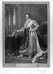
- Helmut Kohl, former German chancellor (1982-1998)
- Ernst Lehmann, Zeppelin captain of the “Hindenburg”
Sister cities
Ludwigshafen is twinned with:
 Antwerp, Belgium
 Dessau , Germany
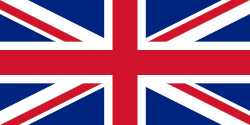 Havering, United Kingdom
 Lorient, France
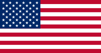 Pasadena, California, U.S.
 Sumgait, Azerbaijan
 Tiszaújváros, Hungary
External links
- Official City Website (German)
- Wilhelm-Hack-Museum (German)
|
|
Important cities and tourist sites in Germany: Area of Heidelberg / Rhine-Neckar |
|
||||||||
|---|---|---|---|---|---|---|---|---|---|---|
|
||||||||||
|
||||||||