Canton of Lucerne
| Luzern | |||
|
|||
| Capital | Lucerne | ||
| Population (2007) | 363,475 (Ranked 7th) | ||
| - Density | 240 /km² | ||
| Area | 1493 km² (Ranked 9th) | ||
| Highest point | 2350 m - Brienzer Rothorn | ||
| Lowest point | 406 m - Reuss plain at Honauer Schachen | ||
| Joined | 1332 | ||
| Abbreviation | LU | ||
| Languages | German | ||
| Executive | Regierungsrat (5) | ||
| Legislative | Grosser Rat (120) | ||
| Municipalities | 107 municipalities | ||
| Districts | 5 Ämter | ||
| Website | www.LU.ch | ||
 |
|||

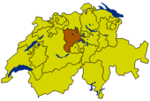
Lucerne (German: Luzern) is a canton of Switzerland. It is located in the centre of Switzerland. The population is 363,475 (as of 2007) of which 57,268 (or 15.8%) are foreigners[1]. The cantonal capital is Lucerne.
Contents |
Geography
The canton of Lucerne is located in the centre of Switzerland. It is drained by the Reuss river and the river Kleine Emme. The lands of the canton lie on the northern foothills of the Swiss Alps (Urner Alps). The highest elevation of the canton of Lucerne is at the Brienzer Rothorn at 2,350m. The area of the canton is 1,493 km².
History
- See also: Swiss peasant war of 1653
The canton of Lucerne comprises territories acquired by its capital Lucerne, either by treaty, armed occupation or purchase, largely by 1415. Lucerne had already joined the Swiss Confederation in 1332. The canton briefly attempted to pursue a policy of separation from 1841-1847 and joined the Sonderbund, which was dissolved by force by a federal army in 1847.
Economy
About nine tenths of the total area is productive land. Agriculture is the most significant source of income, but industry is also developed. The most important agricultural products are crops, fruit and cattle breeding. Industry concentrates on textiles, machinery, paper, wood, tobacco and metallurgical goods.
Tourism is of great importance. The canton of Lucerne is a gateway to holiday resorts in the nearby Alps, and much of the transit traffic between Germany and Italy crosses the region.
Demographics
The population is mainly German speaking and the vast majority is Roman Catholic.
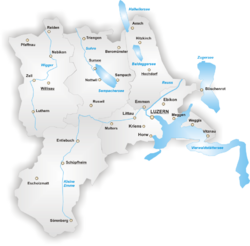
Districts

The Canton of Lucerne is divided into 5 districts termed Ämter:
- Amt Luzern with capital Luzern
- Amt Hochdorf with capital Hochdorf
- Amt Sursee with capital Sursee
- Amt Willisau with capital Willisau
- Amt Entlebuch with capital Schüpfheim
Municipalities
There are 99 municipalities in the canton (as of January 2006[update]).
|
|
|
The municipalities are part of districts (Aemter), named after their capital (bolded above), except for Entlebuch, whose capital is Schüpfheim.
See also: Municipalities of Switzerland
External links
- Official Site (German)
- Public Records Office / State Archive (German)
- Official Statistics
- Geoportal (German) GIS
- Canton of Lucerne in German, French and Italian in the online Historical Dictionary of Switzerland.
References
- ↑ Bundesamt fur Statistik (Federal Department of Statistics) (2008). "Ständige Wohnbevölkerung nach Staatsangehörigkeit, Geschlecht und Kantonen" (Microsoft Excel). Retrieved on November 5, 2008.
|
|||||