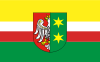
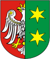
Lubusz Voivodeship
| Lubusz Voivodeship Województwo lubuskie |
|||
| — Voivodeship — | |||
|
|||
 |
|||
 |
|||
| Country | |||
|---|---|---|---|
| Seats | Gorzów Wielkopolski (governor) Zielona Góra (assembly) |
||
| Counties |
2 cities, 12 land counties *
|
||
| Area | |||
| - Total | 13,985 km² (5,399.6 sq mi) | ||
| Population (2006) | |||
| - Total | 1,008,424 | ||
| - Density | 72.1/km² (186.8/sq mi) | ||
| - Urban | 645,991 | ||
| - Rural | 362,433 | ||
| Car plates | F | ||
| * further divided into 83 gminas | |||
| Website: http://www.lubuskie.pl/en/index.php$ | |||
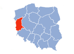
Lubusz Voivodeship (also known as Lubusz Province, or by its Polish name of województwo lubuskie [vɔjɛˈvut͡stfɔ luˈbuskʲɛ] or simply Lubuskie) is a voivodeship (province) in western Poland.
It was created on January 1, 1999, out of the former Gorzów Wielkopolski and Zielona Góra Voivodeships, pursuant to the 1998 Local Government Reorganization Act. The province's name recalls the historic Lubusz Land (Lebus or Lubus), although part of the voivodeship in fact belongs to the historic region of Silesia.
The functions of regional capital are shared between two cities: Gorzów Wielkopolski and Zielona Góra. Gorzów serves as the seat of the centrally appointed voivode or governor, while Zielona Góra is the seat of the elected regional assembly (sejmik) and the executive elected by that assembly, headed by the marszałek.
The region is mainly flat, with many lakes and woodlands. In the south, around Zielona Góra, grapes are cultivated.
Lubusz Voivodeship borders West Pomeranian Voivodeship to the north, Greater Poland Voivodeship to the east, Lower Silesian Voivodeship to the south, and Germany to the west.
Contents |
History
By conquest the first leaders of the Polans, Mieszko I and especially Boleslaw I added a number of surrounding territories to the newly established core Polish state, and Lebus Land or Lubusz in Lusatia came under Polish rule. Part of the historic province was located on the western bank of the Oder River, where the main settlement Lubusz, later known as the German town of Lebus, was located.
In 1226 Lebus Land came under direct jurisdiction of the empire, and around 1250 it was acquired by the Ascanian margraves of Brandenburg. It was thus sometimes referred to by Polish communists as "the first Polish province to fall to German expansionism" (see Drang nach Osten).
In 1945, the conquest of eastern Germany by the Soviet Union was followed by the redrawing of Poland's borders. The east part of the Lubusz (Lebus) region was transferred to Poland, which refers to it as part of the "Regained" or "Recovered Territories".
In the administrative reforms of 1998, the original proposals made no provision for a separate Lubusz voivodeship – Gorzów would have been part of West Pomeranian Voivodeship, Zielona Góra would have been in Lower Silesian Voivodeship, and other parts of the region were assigned to Greater Poland Voivodeship. However, as a result of popular protests, these proposals were eventually amended to increase the number of voivodeships to 16, leading to the creation of Lubusz Voivodeship.
Cities and towns
The voivodeship contains 42 cities and towns. These are listed below in descending order of population (according to official figures for 2006 [1]):
|
1. Gorzów Wielkopolski (125,204) |
22. Rzepin (6,499) |
Administrative division
Lubusz Voivodeship is divided into 14 counties (powiats): 2 city counties and 12 land counties. These are further divided into 83 gminas.
The counties are listed in the following table (ordering within categories is by decreasing population).
| English and Polish names |
Area (km²) |
Population (2006) |
Seat | Other towns | Total gminas |
| City counties | |||||
| Gorzów Wielkopolski | 86 | 125,204 | 1 | ||
| Zielona Góra | 58 | 118,201 | 1 | ||
| Land counties | |||||
| Żary County powiat żarski |
1,393 | 98,929 | Żary | Lubsko, Jasień, Łęknica | 10 |
| Zielona Góra County powiat zielonogórski |
1,571 | 89,543 | Zielona Góra * | Sulechów, Nowogród Bobrzański, Babimost, Czerwieńsk, Kargowa | 10 |
| Nowa Sól County powiat nowosolski |
771 | 86,773 | Nowa Sól | Kożuchów, Bytom Odrzański, Nowe Miasteczko | 8 |
| Żagań County powiat żagański |
1,131 | 82,226 | Żagań | Szprotawa, Iłowa, Małomice, Gozdnica | 9 |
| Gorzów County powiat gorzowski |
1,213 | 65,546 | Gorzów Wielkopolski* | Kostrzyn nad Odrą, Witnica | 7 |
| Międzyrzecz County powiat międzyrzecki |
1,388 | 58,335 | Międzyrzecz | Skwierzyna, Trzciel | 6 |
| Krosno Odrzańskie County powiat krośnieński |
1,390 | 56,463 | Krosno Odrzańskie | Gubin | 7 |
| Świebodzin County powiat świebodziński |
937 | 55,989 | Świebodzin | Zbąszynek | 6 |
| Strzelce-Drezdenko County powiat strzelecko-drezdenecki |
1,248 | 50,151 | Strzelce Krajeńskie | Drezdenko, Dobiegniew | 5 |
| Słubice County powiat słubicki |
1,000 | 46,777 | Słubice | Rzepin, Ośno Lubuskie, Cybinka | 5 |
| Wschowa County powiat wschowski |
625 | 38,958 | Wschowa | Sława, Szlichtyngowa | 3 |
| Sulęcin County powiat sulęciński |
1,177 | 35,329 | Sulęcin | Torzym, Lubniewice | 5 |
| * seat not part of the county | |||||
Protected areas
Protected areas in Lubusz Voivodeship include two National Parks and eight Landscape Parks. These are listed below.
- Drawno National Park (partly in Greater Poland and West Pomeranian Voivodeships)
- Ujście Warty National Park
- Ujście Warty Landscape Park (partly in West Pomeranian Voivodeship)
- Barlinek-Gorzów Landscape Park (partly in West Pomeranian Voivodeship)
- Gryżyna Landscape Park
- Krzesin Landscape Park
- Łagów Landscape Park
- Muskau Bend Landscape Park
- Przemęt Landscape Park (partly in Greater Poland Voivodeship)
- Pszczew Landscape Park (partly in Greater Poland Voivodeship)
See also
- Prussia’s Neumark
External links
- Polish Government Link, Lands conquered by Mieszko I and Boleslaw I
- Official website of Lubusz Voivodeship
- Pictures of Lubusz
|
||||||||||
|
|||||||