Lower Franconia
| Unterfranken Lower Franconia |
|
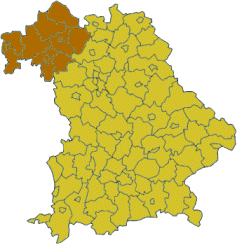
 Map of Bavaria highlighting the Regierungsbezirk of Lower Franconia |
|
| State | Bavaria |
| District seat | Würzburg |
| Area | 9,531.59 km² |
| Population | 1,337,876 (31 Dec. 2006) |
| Pop. density | 140 /km² |
| Web page | regierung.unterfranken.bayern.de |
Lower Franconia (German: Unterfranken) is one of the three administrative regions of Franconia in Bavaria (seven regions), Germany (22 regions in five Federal States, 11 Federal States are not subdivided into regions).
The district was formed in 1817 under the name of Untermainkreis (Lower Main District) and renamed in 1837 as Unterfranken und Aschaffenburg (Lower Franconia and Aschaffenburg). In 1933 the regional Nazi Gauleiter Otto Hellmuth insisted on renaming the district Mainfranken, but after 1945 the name Unterfranken was resurrected.
Unterfranken is the north-west part of Franconia and consists of three district-free cities ("Kreisfreie Städte") and nine country districts ("Landkreise").
The major portion of the Franconian wine region is situated in Lower Franconia.
Contents |
Area and population

| City or District | Population (2006) | Area (km²) | Communities | |||
|---|---|---|---|---|---|---|
| City of Aschaffenburg | 68,664 | 5.1% | 62 | 0.7% | 1 | 0.3% |
| City of Schweinfurt | 53,970 | 4.0% | 36 | 0.4% | 1 | 0.3% |
| City of Würzburg | 134,913 | 10.1% | 88 | 1.0% | 1 | 0.3% |
| Aschaffenburg | 174,543 | 13.0% | 699 | 8.2% | 32 | 10.4% |
| Bad Kissingen | 107,267 | 8.0% | 1,137 | 13.3% | 26 | 8.4% |
| Haßberge | 87,063 | 6.5% | 956 | 11.2% | 26 | 8.4% |
| Kitzingen | 89,378 | 6.7% | 684 | 8.0% | 31 | 10.1% |
| Main-Spessart | 130,678 | 9.8% | 1,322 | 15.5% | 40 | 13.0% |
| Miltenberg | 130,692 | 9.8% | 716 | 8.4% | 32 | 10.4% |
| Rhön-Grabfeld | 85,313 | 6.4% | 1,022 | 12.0% | 37 | 12.0% |
| Schweinfurt | 115,173 | 8.6% | 842 | 9.9% | 29 | 9.4% |
| Würzburg | 160,222 | 12.0% | 968 | 11.3% | 52 | 16.9% |
| Total | 1,337,876 | 100.0% | 8,531 | 100.0% | 308 | 100.0% |
| Historical population | |
| 1910 | 710,943 |
| 1939 | 844,732 |
| 1950 | 1,038,930 |
| 1961 | 1,089,983 |
| 1970 | 1,181,309 |
| 1987 | 1,202,711 |
| 2002 | 1,344,300 |
| 2004 | 1,344,629 |
| 2005 | 1,341,481 |
| 2006 | 1,337,876 |
Historical country districts
Until the municipal reform ( "Kreisreform" ) in June 1972 Lower Franconia had 22 country districts, 16 of them were attached to the other six existing country districts Aschaffenburg, Bad Kissingen, Kitzingen, Miltenberg, Schweinfurt, Würzburg or united to one of the three new country districts Haßberge, Main-Spessart, Rhön-Grabfeld.
| Old country district | Current district(s) |
|---|---|
| Alzenau | Aschaffenburg |
| Bad Brückenau | Bad Kissingen |
| Bad Neustadt/Saale | Rhön-Grabfeld |
| Ebern | Haßberge |
| Gemünden | Main-Spessart |
| Gerolzhofen | Schweinfurt, Kitzingen, Hassberge, Würzburg |
| Hammelburg | Bad Kissingen |
| Haßfurt | Haßberge |
| Hofheim/Unterfranken | Haßberge |
| Karlstadt | Main-Spessart |
| Königshofen | Rhön-Grabfeld |
| Lohr | Main-Spessart |
| Marktheidenfeld | Main-Spessart, Miltenberg, Würzburg |
| Mellrichstadt | Rhön-Grabfeld |
| Obernburg | Miltenberg |
| Ochsenfurt | Würzburg |
Well known people
- Florian Geyer
- Tilman Riemenschneider
- Balthasar Neumann
- Friedrich Rückert
- Wilhelm Conrad Röntgen
- Leonhard Frank
- Carl Diem
- Dirk Nowitzki
Institutes of Higher Education
- Julius-Maximilians-Universität, Würzburg
- Fachhochschule Aschaffenburg
- Fachhochschule Würzburg-Schweinfurt
See also
- Middle Franconia
- Upper Franconia