London Borough of Harrow
| London Borough of Harrow | |
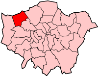 Shown within Greater London |
|
| Geography | |
|---|---|
| Status | London borough |
| Area — Total |
Ranked 299th 50.47 km2 (19.5 sq mi) |
| ONS code | 00AQ |
| Admin HQ | Civic Centre Station Road Harrow HA1 2XY |
| Demographics | |
| Population — Total (2007 est.) — Density |
Ranked 61st (of 354) 214,600 4,252 /km² (11,013 /sq mi) |
| Ethnicity White British White Irish Other White White & Black Caribbean White & Black African White & Asian Other Mixed Indian Pakistani Bangladeshi Other Asian Black Caribbean Black African Other Black Chinese Other |
(2005 estimates)[1] 47.5% 3.7% 4.9% 0.7% 0.4% 1.0% 0.9% 22.0% 2.5% 0.6% 5.5% 3.0% 3.5% 0.5% 1.4% 1.9% |
| Politics | |
| Harrow London Borough Council | |
| Leadership | Leader & Cabinet |
| Mayor | Cllr Jean Lammiman |
| Executive | Conservative |
| MPs | Gareth Thomas Tony McNulty |
| London Assembly — Member |
Brent and Harrow Navin Shah |
| Coat of Arms | |
| Official website | LB Harrow |
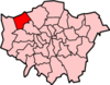
The London Borough of Harrow (pronunciation) is a London borough of outer north-west London. It borders Hertfordshire to the north and other London boroughs: Hillingdon to the west, Ealing to the south, Brent to the south-east and Barnet to the east.
Contents |
History

Harrow was formed in 1934 as an urban district of Middlesex by the Middlesex Review Order 1934, as a merger of the former area of Harrow on the Hill Urban District, Hendon Rural District and Wealdstone Urban District. The local authority was Harrow Urban District Council.
The urban district gained the status of municipal borough on 4 May 1954 and the urban district council became Harrow Borough Council. The 50th anniversary of the incorporation as a borough was celebrated in April 2004, which included a visit by Queen Elizabeth II.
In 1965 the municipal borough was abolished and its former area was transferred to Greater London from Middlesex under the London Government Act 1963 to form the London Borough of Harrow. It is uniquely the only London borough to replicate exactly the unchanged boundaries of a single former district. This was probably because its population was large enough. According to the 1961 census it had a population of 209 080, making it the largest local government district in Middlesex.
Demographics
The presence of Harrow School on the main 'hill' of Harrow has preserved it as a very affluent, leafy area (recent house price averages on the hill were £1,500,000), but the affluence of the hill is now surrounded by typical north-west London suburbia of semi-detached houses and flats.
It is still considered affluent in comparison to other similar areas of London. Crime figures are low; the borough had 1,111 notifiable offences in April 2007, compared with an average of 2,204 across London's boroughs.[2] Harrow Council is focusing regeneration efforts on several tired areas such as Wealdstone and South Harrow and many new 'key service workers'-type flats are springing up. Recently the seemingly terminal decline of its village and town high streets is showing a reverse in fortune with new retail regeneration in several areas. This will take time, but it is inevitable as more people move in and demand modern facilities. In the north part of the borough, there is a greenbelt strip of highly affluent housing located in the areas of Northwood, Pinner and Stanmore. Its location on and near the greenbelt and ease of access to central London (20 minutes by train to Marylebone) makes Harrow a good place to live not only for families but affluent singles as well. Rising property prices in all London areas have helped to see a large increase in property redevelopment of its existing Edwardian and 1920s to 1940s housing stock, which in turn is attracting new residents looking for a clean, safe, and relatively green environment to live in, close to central London.
Harrow is a diverse borough, having 55.2% of its population from the BME (Black and Minority Ethnic) communities, with the largest group being of Indian ethnicity.[3] Since 2005, Harrow Council has held an annual multicultural music and performance arts festival, Under One Sky. Harrow is the most religiously diverse local authority area in the UK, with a 62% chance that two random people are from different religions, according to Office of National Statistics, Oct 2006.[4] It has the highest density of Gujarati Hindus in the UK[5] and growing number of settlers from the African continent, especially over 5000 households from Somalia. There are also a lot of Irish and polish people living in the borough. A large number of Jewish people live in Stanmore and Hatch End.
Education
The borough is often perceived as having a good educational record. The borough features many state-funded primary and secondary schools, as well as a handful of large tertiary colleges. The state school system differs slightly from other London Boroughs, with entry to secondary school starting at the age of 12+ as opposed to 11+, following on from middle schools. Similarly, for a long time the secondary schools of Harrow did not feature integrated sixth-form education, with all school leavers having to join the large tertiary colleges such as Harrow College, Stanmore College or St Dominic's Sixth Form College. There have been critics of the tertiary colleges, with many arguing the standard of education does not continue the standard set by the Borough's secondary schools. Indeed, Harrow suffers a significant number of pupils leaving the Borough for their tertiary education. However, as of 2005-2006 session, select Harrow secondary schools introduced sixth forms in the hope to retain more of the pupils and to provide them an alternative to the large tertiary colleges.
The Borough has a Music Service [2] which provides instrumental tuition for 15% of all Harrow state sector pupils (the national figure is 8% of all state pupils receiving instrumental tuition) and a range of ensemble opportunities for pupils.
The independent schools of the Borough are dominated by the presence of Harrow School, John Lyon School for boys, North London Collegiate School for girls [3], and Heathfield School, Pinner for girls [4], which consistently rank as among the best schools in the country. Notable independent primary schools include Orley Farm School and Reddiford School, both of which are co-educational.
There are also a number of voluntary aided schools in the Borough. These include: Salvatorian College (Roman Catholic, Boys), Sacred Heart Language College (Roman Catholic, Girls) and Moriah Jewish Day School (Jewish, Co-ed) [5].
There are two special needs high schools; Kingsley High School (Co-ed) and Shaftesbury High School (Co-ed).
Other state secondary schools in the London Borough of Harrow are: Bentley Wood High School (Girls); Canons High School (Co-ed); Harrow High School (Co-ed); Hatch End High School (Co-ed); Nower Hill High School (Co-ed); Park High School (Co-ed); Rooks Heath High School (Co-ed); Whitmore High School (Co-ed).
GCSE examination performance 2007
| School | A*-C Pass Rate | School | Point Score | |
|---|---|---|---|---|
| Sacred Heart College | 78% | Park High School | 455.0 | |
| Park High School | 69% | Sacred Heart College | 451.7 | |
| Nower Hill High School | 65% | Nower Hill High School | 423.7 | |
| Salvatorian College | 65% | Canons High School | 413.5 | |
| Whitmore High School | 64% | Whitmore High School | 409.6 | |
| Bentley Wood High School | 61% | Salvatorian College | 407.9 | |
| Hatch End High School | 54% | Bentley Wood High School | 383.1 | |
| Canons High School | 44% | Rooks Heath High School | 371.5 | |
| Rooks Heath High School | 40% | Harrow High School | 365.9 | |
| Harrow High School | 28% | Hatch End High School | 364.1 | |
| Average for London Borough of Harrow | 56.1% | Average for London Borough of Harrow | 399.7 | |
| Average for England | 46.7% | Average for England | 378.1 |
- The table on the left shows the percentage of students gaining five A* to C grades, including English and Maths, for state schools in the London Borough of Harrow
- The table on the right shows the Average Total Point Score per Student for state schools in the London Borough of Harrow.
- Source: Department for Children, Schools and Families - http://www.dcsf.gov.uk/
Notable residents
- Agha Hasan Abedi, founder of BCCI, at one point the sixth largest bank in the world
- Peter André, singer and husband of Jordan, was born in Harrow
- Ronnie Barker, comedian, lived in Pinner
- Sir Roger Bannister, famous runner and neurologist
- Mrs Beeton, the first celebrity cook, lived in Uxbridge Road, Hatch End
- James Blunt, singer, educated at Harrow School
- Kay Burley, Sky News and Dancing on Ice, lives on Harrow-on-the-Hill
- Lord Byron, poet
- Sir Winston Churchill, British Prime Minister, educated at Harrow School
- Brian Cookman, musician, artist and Tai-Chi expert
- Alan Donohoe, singer of The Rakes
- Ian Dury, musician, of Ian Dury and the Blockheads, with the hit single "Hit Me With Your Rhythm Stick"
- Daniel Finkelstein, Comment Editor of the Times newspaper, fought Harrow West constituency in 2001 for the Conservative party but lost to Gareth Thomas, the current Labour MP.
- Gavin Fisher, engineer, former chief designer for the Williams F1 team
- Tom Fletcher, singer/guitarist with McFly born in Harrow
- Anthony Freeman, Rapper.
- Bob Holness, television presenter, lives in Pinner
- Billy Idol singer, born in Stanmore
- Sir Elton John, musician, brought up in Pinner Hill Road
- Simon Le Bon, lead singer of Duran Duran, brought up in North Harrow
- Matt Lucas, comedian, born in Stanmore
- Linsey Dawn McKenzie, model
- Tony McNulty, politician
- Patrick Moore, astronomer, was born in Pinner
- Roger Moore, actor, famous for his role as James Bond and in 'The Saint', lived in Stanmore
- Sir Oswald Mosley, Local MP in the 1920s
- Kate Nash, female singer/musician
- Omar Khan, male producer/rapper
- Royston Maldoom, world famous choreographer born in Harrow
- Adrian Mariappa, Watford FC defender
- Stephanie O'Brien, singer, brought up in Hatch End, one of The Puppini Sisters
- Courtney Pine, jazz musician
- Marco Pirroni, musician, guitarist for Adam and the Ants
- Mark Ramprakash, cricketer, lived in Hatch End
- Claire Rayner, journalist and agony aunt, lives at Harrow on the Hill
- Merlyn Rees, Welsh politician, taught in Harrow Weald Grammar School and lived in Hatch End
- Heath Robinson, cartoonist lived in Pinner[6]
- Michael Rosen, Children's Laureate, 2007-2009, was born in Harrow-on-the-Hill in 1946 and lived in Pinner from 1946-1962
- Scouting For Girls, all members of the pop trio
- Andy Shanlet, famous designer
- Pam St. Clement, actress who plays Pat Evans in EastEnders
- David Suchet, actor, lived in Pinner
- Lord Sutch, eccentric politician and musician
- Gareth Thomas, politician, from North Harrow
- Dave Vanian, lead singer of The Damned
- Vincent Vincent, lead singer of Vincent Vincent and the Villains
- Charlie Watts, drummer with The Rolling Stones, attended Harrow Art College
- Molly Weir, Scottish comedy actress, lived in Pinner until her death
Districts
The borough includes the areas:
- Belmont
- Canons Park
- Harrow
- Harrow on the Hill
- Harrow Weald
- Hatch End
- Headstone
- Kenton
- North Harrow
- Pinner
- Pinner Green
- Queensbury
- Rayners Lane
- Roxeth
- South Harrow
- Stanmore
- Wealdstone
- West Harrow
See also
- Harrow parks and open spaces
- Harrow Borough F.C.
References
- ↑ Data Management and Analysis Group, Greater London Authority, Demography Update October 2007, (2007)
- ↑ Police web site download in Excel format
- ↑ London against gun and knife crime
- ↑ [1]. National Statistics. Accessed 8 October 2006.
- ↑ Minority religions mainly in London. National Statistics. Accessed 5 June 2006.
- ↑ Discover Harrow Guide 2006
External links
- Harrow Council
- Harrow Borough F.C.
- Metros Running Club (Harrow road running club)
- Old Salvatorians (Unofficial)
- [6] harrow buses
- Harrow Times
|
|||||||||||||||||
|
|||||||||||||||||