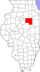
Livingston County, Illinois
| Livingston County, Illinois | |
| Map | |
 Location in the state of Illinois |
|
 Illinois's location in the U.S. |
|
| Statistics | |
| Founded | 1837 |
|---|---|
| Seat | Pontiac |
| Largest city | Pontiac |
| Area - Total - Land - Water |
1,045 sq mi (2,708 km²) 1,044 sq mi (2,703 km²) 2 sq mi (4 km²), 0.16% |
| Population - (2000) - Density |
39,678 38/sq mi (15/km²) |
| Time zone | Central: UTC-6/-5 |
Livingston County is a county located in the U.S. state of Illinois. As of 2000, the population was 39,678. Its county seat is Pontiac, Illinois.[1]
The Pontiac Micropolitan Statistical Area includes all of Livingston County.
Contents |
History
Livingston County was founded on February 27, 1837. It was formed from parts of McLean, LaSalle, and Iroquois counties, and named after Edward Livingston, a prominent politician. He was the mayor of New York City, represented New York in the United States House of Representatives, then represented Louisiana in both houses of Congress. He was Andrew Jackson's Secretary of State, and the United States Minister to France. Although he had no connections to Illinois, the General Assembly found him accomplished enough to name a county after him.
Geography
According to the U.S. Census Bureau, the county has a total area of 1,045 square miles (2,708 km²), of which, 1,044 square miles (2,703 km²) of it is land and 2 square miles (4 km²) of it (0.16%) is water.
Townships
Amity, Avoca, Belle Prairie, Broughton, Charlotte, Chatsworth, Dwight, Eppards Point, Esmen, Fayette, Forrest, Germanville, Indian Grove, Long Point, Nebraska, Nevada, Newtown, Odell, Owego, Pike, Pleasant Ridge, Pontiac, Reading, Rooks Creek, Round Grove, Saunemin, Sullivan, Sunbury, Union, Waldo
Adjacent counties
- Grundy County - north
- Kankakee County - northeast
- Ford County - southeast
- McLean County - southwest
- Woodford County - west
- LaSalle County - northwest
Demographics
| Historical populations | |||
|---|---|---|---|
| Census | Pop. | %± | |
| 1900 | 42,035 |
|
|
| 1910 | 40,465 | −3.7% | |
| 1920 | 39,070 | −3.4% | |
| 1930 | 39,092 | 0.1% | |
| 1940 | 38,838 | −0.6% | |
| 1950 | 37,809 | −2.6% | |
| 1960 | 40,341 | 6.7% | |
| 1970 | 40,690 | 0.9% | |
| 1980 | 41,381 | 1.7% | |
| 1990 | 39,301 | −5% | |
| 2000 | 39,678 | 1% | |
| IL Counties 1900-1990 | |||
As of the census[2] of 2000, there were 39,678 people, 14,374 households, and 9,946 families residing in the county. The population density was 38 people per square mile (15/km²). There were 15,297 housing units at an average density of 15 per square mile (6/km²). The racial makeup of the county was 92.32% White, 5.17% Black or African American, 0.17% Native American, 0.31% Asian, 0.01% Pacific Islander, 1.22% from other races, and 0.80% from two or more races. 2.66% of the population were Hispanic or Latino of any race. 35.6% were of German, 15.4% American, 12.4% Irish and 7.5% English ancestry according to Census 2000. 96.8% spoke English and 2.4% Spanish as their first language.
There were 14,374 households out of which 32.90% had children under the age of 18 living with them, 56.80% were married couples living together, 8.80% had a female householder with no husband present, and 30.80% were non-families. 26.80% of all households were made up of individuals and 12.50% had someone living alone who was 65 years of age or older. The average household size was 2.51 and the average family size was 3.04.
In the county the population was spread out with 25.00% under the age of 18, 8.20% from 18 to 24, 29.60% from 25 to 44, 21.90% from 45 to 64, and 15.30% who were 65 years of age or older. The median age was 37 years. For every 100 females there were 97.60 males. For every 100 females age 18 and over, there were 95.50 males.
The median income for a household in the county was $41,342, and the median income for a family was $47,958. Males had a median income of $36,414 versus $23,479 for females. The per capita income for the county was $18,347. About 5.80% of families and 8.80% of the population were below the poverty line, including 9.90% of those under age 18 and 8.50% of those age 65 or over.
The Halloween Movie County
The county is well known for the horror movie franchise Halloween and where Michael Myers resides in the fictional town of Haddonfield, Illinois.
Cities and towns
- Campus
- Chatsworth
- Cornell
- Cullom
- Dwight
- Emington
- Fairbury
- Flanagan
- Forrest
- Long Point
- Odell
- Pontiac
- Saunemin
- Strawn
|
||||||||||||||||||||||||||
|