Regions of New Zealand
| New Zealand | |
 This article is part of the series: |
|
|
|
|
|
Executive (The Crown)
Elections
Regions and territories
General
|
|
|
Other countries · Atlas |
|
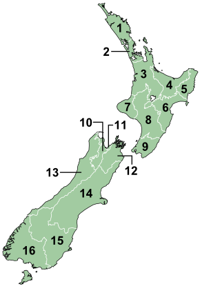
The region is the top tier of local government in New Zealand. There are 16 regions of New Zealand. Twelve are governed by an elected regional council, while four are governed by territorial authorities (the second tier of local government) which also perform the functions of a regional council and thus are known as unitary authorities. The Chatham Islands Council is similar to a unitary authority, but is authorised under its own enabling legislation.[1]
Contents |
History and statutory basis
A regional council means one of the regional councils listed in Part 1 of Schedule 2 of the Local Government Act 2002.[2] That schedule lists the regional councils of New Zealand and their Gazette notices following their establishment in 1989.[3] The Local Government Act 2002 also requires regional councils to promote sustainable development – the social, economic, environmental and cultural well-being of their communities.[4]
The current regions and their councils came about in 1989, as a result of an amalgamation procedure carried out under the Local Government Act 1974. The geographic extent of the regions was largely based on river catchments (with major watersheds such as the Southern Alps being the boundaries). This anticipated the responsibilities of the Resource Management Act 1991.[5] Some regional boundaries are identical to territorial authority boundaries but there are plenty of exceptions. The southern boundary of the Auckland Region, for example, cuts through the middle of Franklin District.
Responsibilities
Regional authorities are primarily responsible for environmental management, including water, contaminant discharge and coastal management, river and lake management including flood and drainage control, regional land management; regional transport (including public transport) and harbours, biosecurity or pest management; while territorial authorities are responsible for: local-level land use management (urban and rural planning); network utility services such as water, sewerage, stormwater and solid waste management; local roads; libraries; parks and reserves; and community development. Property rates (land taxes) are used to fund both regional and territorial government activities. There is often a high degree of co-operation between regional and territorial councils as they have complementary roles.
Resource management functions
Regional Councils have these specific functions under the Resource Management Act 1991.
- Planning for the integrated management of natural and physical resources [6]
- Planning for regionally significant land uses [7]
- Soil conservation, water quality and quantity, water ecosystems, natural hazards, hazardous substances [8]
- Controlling the coastal marine area [9]
- Controlling via resource consents the taking, use, damming or diverting of water [10]
- Controlling via resource consents the discharge of contaminants [11]
- Establishing of rules in a regional plan to allocate water [12]
- Controlling via resource consents the beds of waterbodies [13]
Other functions
Regional Councils also have responsibility for a number of other functions under other statutes;[14]
- flood and river control under the Soil Conservation and Rivers Control Act 1941,
- reserves vested in regional councils under the Reserves Act 1977,
- civil defence under the Civil Defence Act 1990,
- regional pest management under the Biosecurity Act 1993,
- harbour and water navigation under the Maritime Transport Act 1994,
- hazardous waste under the HSNO Act 1996, and,
- public transport planning under the Land Transport Act 1998.
Regional councils were also given responsibilities for the supervision of the safety of dams in the Building Act 2004.[15]
List of regions
 |
Region | Regional council | Principal city | Area (km²) | Population[16] | ISO 3166-2 Code | |
|---|---|---|---|---|---|---|---|
| 1 | Northland | Northland Regional Council | Whangarei | 13,941 | 154,700 | NZ-NTL |
|
| 2 | Auckland | Auckland Regional Council | Auckland | 16,140 | 1,414,800 | NZ-AUK |
|
| 3 | Waikato | Waikato Regional Council | Hamilton | 25,598 | 402,200 | NZ-WKO |
|
| 4 | Bay of Plenty | Bay of Plenty Regional Council | Tauranga | 12,447 | 269,900 | NZ-BOP |
|
| 5 | East Cape (1) | Gisborne District Council | Gisborne | 8,351 | 46,000 | NZ-GIS |
|
| 6 | Hawke's Bay | Hawke's Bay Regional Council | Napier | 14,164 | 152,700 | NZ-HKB |
|
| 7 | Taranaki | Taranaki Regional Council | New Plymouth | 7,273 | 107,500 | NZ-TKI |
|
| 8 | Manawatu-Wanganui | Manawatu-Wanganui Regional Council (Horizons Regional Council) |
Palmerston North | 22,215 | 229,200 | NZ-MWT |
|
| 9 | Wellington | Wellington Regional Council | Wellington | 8,124 | 473,700 | NZ-WGN |
|
| 10 | Tasman (1) | Tasman District Council | Richmond | 9,786 | 46,500 | NZ-TAS |
|
| 11 | Nelson (1) | Nelson City Council | Nelson | 445 | 44,700 | NZ-NSN |
|
| 12 | Marlborough (1) | Marlborough District Council | Blenheim | 12,484 | 44,500 | NZ-MBH |
|
| 13 | West Coast | West Coast Regional Council | Greymouth | 23,000 | 32,300 | NZ-WTC |
|
| 14 | Canterbury | Canterbury Regional Council | Christchurch | 45,845 | 552,800 | NZ-CAN |
|
| 15 | Otago | Otago Regional Council | Dunedin | 31,476 | 203,500 | NZ-OTA |
|
| 16 | Southland | Southland Regional Council | Invercargill | 30,753 | 93,000 | NZ-STL |
|
|
(1) These regions are Unitary Authorities. |
|||||||
Areas outside regional boundaries
New Zealand has a number of outlying islands that are not included within regional boundaries. The Chatham Islands is not in a region, although its council has some of the powers of a regional council under the Resource Management Act. The Kermadecs and the sub-Antarctic islands are inhabited only by a small number of Department of Conservation staff. The Conservation Minister is empowered to act as a regional council for these islands.
Governance
Regional councils are popularly elected every three years in accordance with the Local Electoral Act 2001.[17] Councils may use a first past the post or single transferable vote system. The Chairperson of a regional council is selected by the elected council members.[18]
See also
- Provinces of New Zealand
- Territorial authorities of New Zealand
- Local Government New Zealand
- List of towns in New Zealand
External links
References
- ↑ Chatham Islands Council Act 1995, Parliament of New Zealand, 1995, Statute No 041, Commenced: 1 November 1995, retrieved 4 February 2008.
- ↑ "Local Government Act 2002 No 84 - Interpretation". Retrieved on 2008-07-17.
- ↑ "Local Government Act 2002 No 84 - Part 1, Schedule 2". Retrieved on 2008-07-17.
- ↑ Relationship between the Local Government Act and the RMA Quality Planning The RMA Resource, retrieved 11 October 2007.
- ↑ New Zealand Historical Atlas – McKinnon, Malcolm (Editor); David Bateman, 1997, Plate 98
- ↑ Resource Management Act, Section 30(1)(a)- Parliament of New Zealand, 1991
- ↑ Resource Management Act, Section 30(1)(b)- Parliament of New Zealand, 1991
- ↑ Resource Management Act, Section 30(1)(c)- Parliament of New Zealand, 1991
- ↑ Resource Management Act, Section 30(1)(d)- Parliament of New Zealand, 1991
- ↑ Resource Management Act, Section 30(1)(e)- Parliament of New Zealand, 1991
- ↑ Resource Management Act, Section 30(1)(f)- Parliament of New Zealand, 1991
- ↑ Resource Management Act, Section 30(1)(fa)- Parliament of New Zealand, 1991. NB this is a new subsection added in 2005.
- ↑ Resource Management Act, Section 30(1)(g)- Parliament of New Zealand, 1991
- ↑ Harris, R. (2004) 'Local government and development legislation', Chapter 3G, Handbook of Environmental Law, Editor Harris, R., ISBN 0959785183, Royal Forest and Bird Protection Society of New Zealand, Wellington 2004, page 130.
- ↑ Sections 135, 142, 150, and 154 Building Act 2004, Parliament of New Zealand.
- ↑ "Subnational Population Estimates: At 30 June 2008". Statistics New Zealand (23 October 2008). Retrieved on 2008-10-28.
- ↑ Local Government Act 2002, s41(1)(a), Parliament of New Zealand.
- ↑ Local Government Act 2002, s41(1)(b), Parliament of New Zealand.
|
||||||||||||||
| Administrative divisions of New Zealand | |||||||||||
|---|---|---|---|---|---|---|---|---|---|---|---|
| Supranational level | Realm of New Zealand | ||||||||||
| National level | New Zealand | Tokelau | Cook Islands | Niue | Ross Dependency | ||||||
| Regions | 12 non-unitary regions | 4 unitary regions | Chatham Islands | Kermadec Islands | sub-Antarctic islands | ||||||
| Territorial authorities | 16 cities and 57 districts | ||||||||||
| Notes | Some districts lie in more than one region | These combine the regional and the territorial authority levels in one | Special territorial authority | Areas outside regional authority; these, plus the Chatham Islands and the Solander Islands, form the New Zealand outlying islands | State administered by New Zealand | States in free association with New Zealand | Claimed by New Zealand, but claim frozen by the Antarctic Treaty | ||||
|
||||||||||||||||||||

