List of counties in North Carolina

The U.S. State of North Carolina is divided into 100 counties. North Carolina ranks 28th in size by area, but has the seventh most counties in the country.[1]
Following the restoration of the monarchy in 1660, Charles II of England rewarded eight persons on March 24, 1663, for their faithful support in his efforts to regain the throne of England. He granted the eight grantees, called Lords Proprietor, the land called Carolina, in honor of Charles I, his father. The Province of Carolina from 1663 to 1729, was a North American British colony. In 1729, the Province of North Carolina was officially divided from the Province of South Carolina.
North Carolina county history stretches over 340 years, beginning in 1668 with the creation of Albemarle County and ending with the 1911 creation of Avery and Hoke counties. Five counties have since been divided or abolished altogether, the last being Dobbs County in 1791.
The Federal Information Processing Standard (FIPS),[2] which is used by the United States government to uniquely identify states and counties, is provided with each entry. North Carolina's FIPS code is 37, which when combined with the county code is written as 37XXX.
List
| County |
FIPS Code [2] |
County Seat [3] |
Created [3] |
Origin [4] |
Etymology [4] |
Population (2000)[3][5] |
Area [3][5] |
Map |
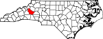
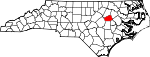
| Alamance County | 001 | Graham | 1849 | Orange County | The Battle of Alamance which was derived from the local Native American word meaning "blue clay" found in the Great Alamance Creek | 130,800 | 435 sq mi (1,127 km²) |

|
|---|---|---|---|---|---|---|---|---|
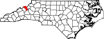
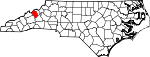
| Alexander County | 003 | Taylorsville | 1847 | Caldwell County, Iredell County, and Wilkes County | William J. Alexander, member of the legislature and Speaker of the North Carolina House of Commons | 33,603 | 263 sq mi (681 km²) |
|
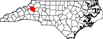
| Alleghany County | 005 | Sparta | 1859 | Ashe County | Derived from a corruption of the Delaware Indian name for the Allegheny and Ohio Rivers and is said to have meant "a fine stream" | 10,667 | 236 sq mi (611 km²) |

|
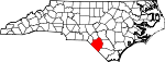
| Anson County | 007 | Wadesboro | 1750 | Bladen County | George, Lord Anson (1697–1762), a celebrated English admiral who circumnavigated the globe | 25,275 | 537 sq mi (1,391 km²) |
|
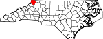
| Ashe County | 009 | Jefferson | 1799 | Wilkes County | Samuel Ashe (1725–1813), a Revolutionary patriot, superior court judge, and governor of North Carolina | 24,384 | 427 sq mi (1,106 km²) |
|
| Avery County | 011 | Newland | 1911 | Caldwell County, Mitchell County, and Watauga County | Waightstill Avery (1741–1821), a soldier of the Revolution and Attorney General of North Carolina | 17,167 | 247 sq mi (640 km²) |

|
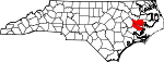
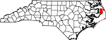
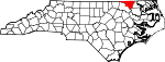
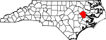
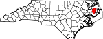
| Beaufort County | 013 | Washington | 1712 | Original county | Henry Somerset, Duke of Beaufort, who in 1709 became one of the Lords Proprietor | 44,958 | 959 sq mi (2,484 km²) |
|
| Bertie County | 015 | Windsor | 1722 | Chowan County | James or Henry Bertie, two Lords Proprietor of colonial North Carolina | 19,773 | 741 sq mi (1,919 km²) |
|
| Bladen County | 017 | Elizabethtown | 1734 | New Hanover County | Martin Bladen, a member of the Board of Trade | 32,278 | 887 sq mi (2,297 km²) |
|
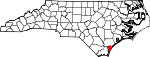
| Brunswick County | 019 | Bolivia | 1764 | Bladen County and New Hanover County | George I of Great Britain (1660–1727), Duke of Brunswick and Lüneburg | 73,143 | 1,050 sq mi (2,719 km²) |
|
| Buncombe County | 021 | Asheville | 1791 | Burke County and Rutherford County | Edward Buncombe, a Revolutionary soldier, who was wounded and captured at the Battle of Germantown, and died a paroled prisoner in Philadelphia | 206,330 | 660 sq mi (1,709 km²) |

|
| Burke County | 023 | Morganton | 1777 | Rowan County | Thomas Burke (1747–1783), a member of the Continental Congress and governor of North Carolina | 89,148 | 515 sq mi (1,334 km²) |
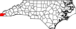
|
| Cabarrus County | 025 | Concord | 1792 | Mecklenburg County | Stephen Cabarrus (1754–1808), member of the legislature and Speaker of the North Carolina House of Commons | 131,063 | 365 sq mi (945 km²) |
|
| Caldwell County | 027 | Lenoir | 1841 | Burke County and Wilkes County | Joseph Caldwell (1773–1835), the first president of the University of North Carolina | 77,415 | 474 sq mi (1,228 km²) |
|
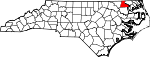
| Camden County | 029 | Camden | 1777 | Pasquotank County | Charles Pratt, 1st Earl Camden (1714–1794), who opposed the taxation of the American colonists | 6,885 | 306 sq mi (793 km²) |

|
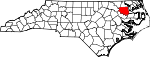
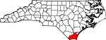
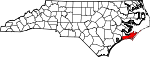
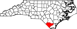
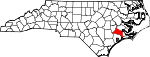
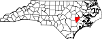
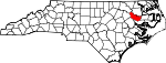
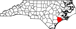
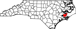
| Carteret County | 031 | Beaufort | 1722 | Craven County | John Carteret, 2nd Earl Granville (1690–1763), who inherited one-eighth share in the Province of Carolina through his great-grandfather George Carteret | 59,383 | 1,341 sq mi (3,473 km²) |
|
| Caswell County | 033 | Yanceyville | 1777 | Orange County | Richard Caswell (1729–1789), member of the first Continental Congress and first governor of North Carolina after the Declaration of Independence | 23,501 | 428 sq mi (1,109 km²) |
|
| Catawba County | 035 | Newton | 1842 | Lincoln County | Catawba Nation | 141,685 | 414 sq mi (1,072 km²) |
|
| Chatham County | 037 | Pittsboro | 1771 | Orange County | William Pitt, 1st Earl of Chatham (1708–1778), Secretary of State during the French and Indian War and was later Prime Minister of Great Britain | 49,329 | 709 sq mi (1,836 km²) |
|
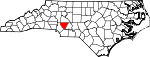
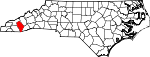
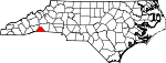
| Cherokee County | 039 | Murphy | 1839 | Macon County | Cherokee Nation | 24,298 | 497 sq mi (1,287 km²) |
|
| Chowan County | 041 | Edenton | 1668 | Albemarle County | Chowan Native American tribe | 14,526 | 233 sq mi (603 km²) |

|
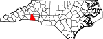
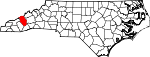
| Clay County | 043 | Hayesville | 1861 | Cherokee County | Henry Clay (1777–1852), statesman and orator who represented Kentucky in both the House of Representatives and Senate | 8,775 | 221 sq mi (572 km²) |

|
| Cleveland County | 045 | Shelby | 1841 | Lincoln County and Rutherford County | Benjamin Cleveland (1738–1806), a colonel in the American Revolutionary War who took part in the Battle of Kings Mountain | 96,287 | 469 sq mi (1,215 km²) |
|
| Columbus County | 047 | Whiteville | 1808 | Bladen County and Brunswick County | Christopher Columbus (1451–1507), navigator, explorer, and one of the first Europeans to explore the Americas | 54,749 | 954 sq mi (2,471 km²) |
|
| Craven County | 049 | New Bern | 1712 | Bath County | William Craven, 1st Earl of Craven (1608–1697), who was a Lords Proprietor of colonial North Carolina | 91,436 | 774 sq mi (2,005 km²) |
|
| Cumberland County | 051 | Fayetteville | 1754 | Bladen County | Prince William, Duke of Cumberland (1721–1765), a military leader and son of George II | 302,963 | 658 sq mi (1,704 km²) |
|
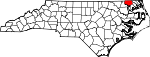
| Currituck County | 053 | Currituck | 1668 | Albemarle County | Traditionally said to be an American Indian word for wild geese, also rendered "Coratank" | 18,190 | 526 sq mi (1,362 km²) |

|
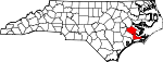
| Dare County | 055 | Manteo | 1870 | Currituck County, Hyde County, and Tyrrell County | Virginia Dare (b. 1587), the first child born of English parents in America | 29,967 | 1,562 sq mi (4,046 km²) |
|
| Davidson County | 057 | Lexington | 1822 | Rowan County | William Lee Davidson (1746–1781), an American Revolutionary War general who was mortally wounded at Cowan's Ford | 147,246 | 567 sq mi (1,469 km²) |
|
| Davie County | 059 | Mocksville | 1836 | Rowan County | William Richardson Davie (1756–1820), a member of the Federal Convention and governor of North Carolina | 34,835 | 267 sq mi (692 km²) |
|
| Duplin County | 061 | Kenansville | 1750 | New Hanover County | Thomas Hay, Viscount Dupplin (1710–1787), who was the 9th Earl of Kinnoull | 49,063 | 819 sq mi (2,121 km²) |
|
| Durham County | 063 | Durham | 1881 | Orange County and Wake County | The city of Durham which was named in honor of Dr. Bartlett Snipes Durham who donated the land on which the railroad station was located | 223,314 | 298 sq mi (772 km²) |

|
| Edgecombe County | 065 | Tarboro | 1741 | Bertie County | Richard Edgcumbe, 1st Baron Edgcumbe (1680–1758), a Lord High Treasurer and Paymaster-General for Ireland | 55,606 | 507 sq mi (1,313 km²) |
|
| Forsyth County | 067 | Winston-Salem | 1849 | Stokes County | Benjamin Forsyth (d. 1814), an American officer during the War of 1812 | 306,067 | 413 sq mi (1,070 km²) |
|
| Franklin County | 069 | Louisburg | 1779 | Bute County | Benjamin Franklin (1706–1790), an author, politician, statesman, and Founding Father of the United States | 47,260 | 495 sq mi (1,282 km²) |
|
| Gaston County | 071 | Gastonia | 1846 | Lincoln County | William Gaston (1778–1844), a United States Congressman and justice of the North Carolina Supreme Court | 190,365 | 364 sq mi (943 km²) |

|
| Gates County | 073 | Gatesville | 1779 | Chowan County, Hertford County, and Perquimans County | Horatio Gates (1727–1806), an American general during the Revolution at the Battle of Saratoga | 10,516 | 346 sq mi (896 km²) |
|
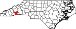
| Graham County | 075 | Robbinsville | 1872 | Cherokee County | William Alexander Graham (1804–1875), a United States Senator, governor of North Carolina, and United States Secretary of the Navy | 7,993 | 302 sq mi (782 km²) |

|
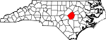
| Granville County | 077 | Oxford | 1746 | Edgecombe County | John Carteret, 2nd Earl Granville (1690–1763), who inherited one-eighth share in the Province of Carolina through his great-grandfather George Carteret | 48,498 | 537 sq mi (1,391 km²) |
|
| Greene County | 079 | Snow Hill | 1791 | Dobbs County Originally named Glasgow County |
Nathanael Greene (1742–1786), a major general of the Continental Army in the American Revolutionary War | 18,794 | 266 sq mi (689 km²) |
|
| Guilford County | 081 | Greensboro | 1771 | Orange County and Rowan County | Francis North, 1st Earl of Guilford (1704–1790), a British politician and father of Prime Minister of Great Britain Frederick North | 421,048 | 658 sq mi (1,704 km²) |

|
| Halifax County | 083 | Halifax | 1758 | Edgecombe County | George Montagu-Dunk, 2nd Earl of Halifax (1716–1771), a British statesman and President of the Board of Trade | 57,370 | 731 sq mi (1,893 km²) |
|
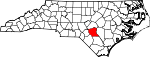
| Harnett County | 085 | Lillington | 1855 | Cumberland County | Cornelius Harnett (1723–1781), an American Revolutionary and delegate in the Continental Congress | 91,025 | 601 sq mi (1,557 km²) |
|
| Haywood County | 087 | Waynesville | 1808 | Buncombe County | John Haywood (1754–1827), a North Carolina State Treasurer | 54,033 | 555 sq mi (1,437 km²) |
|
| Henderson County | 089 | Hendersonville | 1838 | Buncombe County | Leonard Henderson (1772–1833), Chief Justice of the North Carolina Supreme Court | 89,173 | 375 sq mi (971 km²) |
|
| Hertford County | 091 | Winton | 1759 | Bertie County, Chowan County, and Northampton County | Francis Seymour-Conway, 1st Marquess of Hertford (1718–1794), who was Lord of the Bedchamber to George II and George III | 22,601 | 360 sq mi (932 km²) |
|
| Hoke County | 093 | Raeford | 1911 | Cumberland County and Robeson County | Robert Hoke (1837–1912), a Confederate general during the American Civil War | 33,646 | 392 sq mi (1,015 km²) |
|
| Hyde County | 095 | Swan Quarter | 1705 | Original county Originally named Wickham County |
Edward Hyde (c. 1650–1712), a governor of colonial North Carolina | 5,826 | 1,424 sq mi (3,688 km²) |

|
| Iredell County | 097 | Statesville | 1788 | Rowan County | James Iredell (1751–1799), a comptroller at the port of Edenton and one of the original justices of the Supreme Court of the United States | 122,660 | 597 sq mi (1,546 km²) |
|
| Jackson County | 099 | Sylva | 1851 | Haywood County and Macon County | Andrew Jackson (1767–1845), the 7th President of the United States | 33,121 | 494 sq mi (1,279 km²) |
|
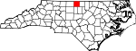
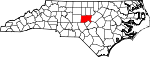
| Johnston County | 101 | Smithfield | 1746 | Craven County | Gabriel Johnston (1699–1752), a governor of colonial North Carolina | 121,965 | 796 sq mi (2,062 km²) |
|
| Jones County | 103 | Trenton | 1779 | Craven County | Willie Jones (1740–1801), opposed the ratification of the United States Constitution and declined an invitation to the Constitutional Convention | 10,381 | 473 sq mi (1,225 km²) |
|
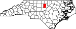
| Lee County | 105 | Sanford | 1907 | Chatham County and Moore County | Robert E. Lee (1807–1870), a career United States Army officer and general of the Confederate forces during the American Civil War | 49,040 | 259 sq mi (671 km²) |

|
| Lenoir County | 107 | Kinston | 1791 | Dobbs County Originally named Glasgow County |
William Lenoir (1751–1839), a captain in the American Revolutionary War who took part in the Battle of Kings Mountain | 59,648 | 402 sq mi (1,041 km²) |
|
| Lincoln County | 109 | Lincolnton | 1779 | Tryon County | Benjamin Lincoln (1733–1810), a major general during the American Revolutionary War who participated in the Siege of Yorktown | 63,780 | 307 sq mi (795 km²) |

|
| McDowell County | 111 | Marion | 1842 | Burke County and Rutherford County | Joseph McDowell (1756–1801), a soldier in the American Revolutionary War who took part in the Battle of Kings Mountain | 42,151 | 446 sq mi (1,155 km²) |

|
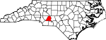
| Macon County | 113 | Franklin | 1828 | Haywood County | Nathaniel Macon (1758–1837), a member and Speaker of the United States House of Representatives | 29,811 | 519 sq mi (1,344 km²) |

|
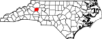
| Madison County | 115 | Marshall | 1851 | Buncombe County and Yancey County | James Madison (1751–1836), the 4th President of the United States | 19,635 | 452 sq mi (1,171 km²) |
|
| Martin County | 117 | Williamston | 1774 | Halifax County and Tyrrell County | Josiah Martin (1737–1786), the last governor of colonial North Carolina | 25,593 | 461 sq mi (1,194 km²) |
|
| Mecklenburg County | 119 | Charlotte | 1762 | Anson County | Charlotte of Mecklenburg-Strelitz (1744–1818), the queen consort of George III of the United Kingdom | 695,454 | 546 sq mi (1,414 km²) |
|
| Mitchell County | 121 | Bakersville | 1861 | Burke County, Caldwell County, McDowell County, Watauga County, and Yancey County | Elisha Mitchell (1793–1857), a professor at the University of North Carolina who measured the height of Mount Mitchell | 15,687 | 222 sq mi (575 km²) |
|
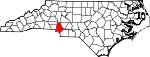
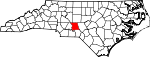
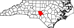
| Montgomery County | 123 | Troy | 1779 | Anson County | Richard Montgomery (1738–1775), a major general during the Revolutionary War who was killed at the Battle of Quebec | 26,822 | 502 sq mi (1,300 km²) |
|
| Moore County | 125 | Carthage | 1784 | Cumberland County | Alfred Moore (1755–1810), a captain in the Revolutionary War and justice of the Supreme Court of the United States | 74,769 | 706 sq mi (1,829 km²) |
|
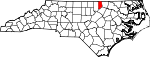
| Nash County | 127 | Nashville | 1777 | Edgecombe County | Francis Nash (1742–1777), a brigadier general in the Revolutionary War who was mortally wounded at the Battle of Germantown | 87,420 | 543 sq mi (1,406 km²) |
|
| New Hanover County | 129 | Wilmington | 1729 | Craven County | The royal family of England, members of the House of Hanover | 160,307 | 328 sq mi (850 km²) |
|
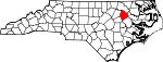
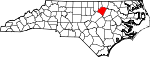
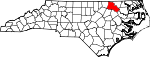
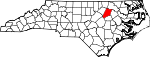
| Northampton County | 131 | Jackson | 1741 | Bertie County | James Compton, 5th Earl of Northampton (1687–1754), a British peer and politician | 22,086 | 551 sq mi (1,427 km²) |
|
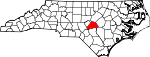
| Onslow County | 133 | Jacksonville | 1734 | New Hanover County | Arthur Onslow (1691–1768), Speaker of the British House of Commons | 150,355 | 909 sq mi (2,354 km²) |
|
| Orange County | 135 | Hillsborough | 1752 | Bladen County, Granville County, and Johnston County | William V, Prince of Orange (1748–1806), the last Stadtholder of the Dutch Republic | 118,227 | 401 sq mi (1,039 km²) |
|
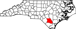
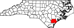
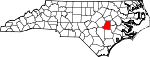
| Pamlico County | 137 | Bayboro | 1872 | Beaufort County and Craven County | Pamlico Sound and the Pamlico Native American tribe | 12,934 | 566 sq mi (1,466 km²) |
|
| Pasquotank County | 139 | Elizabeth City | 1668 | Albemarle County | Derived from the Native American word pasketanki which meant "where the current of the stream divides or forks" | 34,897 | 289 sq mi (749 km²) |

|
| Pender County | 141 | Burgaw | 1875 | New Hanover County | William Dorsey Pender (1834–1863), Confederate soldier who was mortally wounded at the Battle of Gettysburg of the American Civil War | 41,082 | 933 sq mi (2,416 km²) |
|
| Perquimans County | 143 | Hertford | 1668 | Albemarle County | Perquimans Native American tribe | 11,368 | 329 sq mi (852 km²) |

|
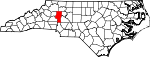
| Person County | 145 | Roxboro | 1791 | Caswell County | Thomas Person, an American Revolutionary War patriot | 35,623 | 404 sq mi (1,046 km²) |

|
| Pitt County | 147 | Greenville | 1760 | Beaufort County | William Pitt, 1st Earl of Chatham (1708–1778), Secretary of State during the French and Indian War and was later Prime Minister of Great Britain | 133,798 | 655 sq mi (1,696 km²) |
|
| Polk County | 149 | Columbus | 1855 | Henderson County and Rutherford County | William Polk (1758–1834), officer in the American Revolutionary War and first president of the State Bank of North Carolina | 18,324 | 239 sq mi (619 km²) |
|
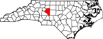
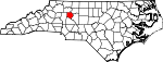
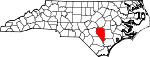
| Randolph County | 151 | Asheboro | 1779 | Guilford County | Peyton Randolph (c. 1721–1755), the first President of the Continental Congress | 130,454 | 790 sq mi (2,046 km²) |

|
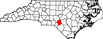
| Richmond County | 153 | Rockingham | 1779 | Anson County | Charles Lennox, 3rd Duke of Richmond (1735–1806), a firm supporter of the American colonists and advocated removal of British troops | 46,564 | 480 sq mi (1,243 km²) |

|
| Robeson County | 155 | Lumberton | 1787 | Bladen County | Thomas Robeson, an officer in the American Revolutionary War | 123,339 | 951 sq mi (2,463 km²) |
|
| Rockingham County | 157 | Wentworth | 1785 | Guilford County | Charles Watson-Wentworth, 2nd Marquess of Rockingham (1730–1782), a British statesmen and two-time Prime Minister of Great Britain | 91,928 | 572 sq mi (1,481 km²) |

|
| Rowan County | 159 | Salisbury | 1753 | Anson County | Matthew Rowan (d. 1769), was the acting Governor of colonial North Carolina following the death of Governor Nathaniel Rice | 130,340 | 524 sq mi (1,357 km²) |

|
| Rutherford County | 161 | Rutherfordton | 1779 | Tryon County | Griffith Rutherford (c. 1721–1805), an officer in the American Revolutionary War and a political leader in North Carolina | 62,889 | 566 sq mi (1,466 km²) |

|
| Sampson County | 163 | Clinton | 1784 | Duplin County | John Sampson, a member of Josiah Martin's council | 60,161 | 947 sq mi (2,453 km²) |
|
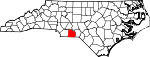
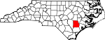
| Scotland County | 165 | Laurinburg | 1899 | Richmond County | The country Scotland, part of the United Kingdom | 35,998 | 321 sq mi (831 km²) |

|
| Stanly County | 167 | Albemarle | 1841 | Montgomery County | John Stanly (1774–1834), a United States Congressman and Speaker of the North Carolina House of Commons | 58,100 | 404 sq mi (1,046 km²) |
|
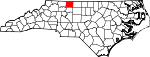
| Stokes County | 169 | Danbury | 1789 | Surry County | John Stokes, a soldier of the Revolution who was seriously wounded at the Waxhaw massacre | 44,711 | 456 sq mi (1,181 km²) |
|
| Surry County | 171 | Dobson | 1771 | Rowan County | The county of Surrey in England, birthplace of then governor William Tryon | 71,219 | 538 sq mi (1,393 km²) |

|
| Swain County | 173 | Bryson City | 1871 | Jackson County and Macon County | David Lowry Swain (1801–1868), a governor of North Carolina and president of the University of North Carolina | 12,968 | 541 sq mi (1,401 km²) |

|
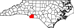
| Transylvania County | 175 | Brevard | 1861 | Henderson County and Jackson County | Derived from the Latin words, trans meaning across and sylva meaning woods | 29,334 | 381 sq mi (987 km²) |

|
| Tyrrell County | 177 | Columbia | 1729 | Chowan County, Currituck County, and Pasquotank County | John Tyrrell, at one time was a Lords Proprietor | 4,149 | 600 sq mi (1,554 km²) |
|
| Union County | 179 | Monroe | 1842 | Anson County and Mecklenburg County | Created as a compromise after a dispute between local Whigs and Democrats as to whether it should be named Clay or Jackson county | 123,677 | 640 sq mi (1,658 km²) |
|
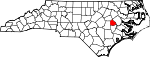
| Vance County | 181 | Henderson | 1881 | Franklin County, Granville County, and Warren County | Zebulon Baird Vance (1830–1894), a Confederate military officer in the American Civil War, twice governor of North Carolina, and United States Senator | 42,954 | 270 sq mi (699 km²) |
|
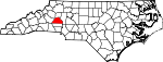
| Wake County | 183 | Raleigh | 1771 | Cumberland County, Johnston County, and Orange County | Margaret Wake, the wife of British colonial governor William Tryon | 627,846 | 857 sq mi (2,220 km²) |

|
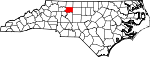
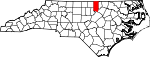
| Warren County | 185 | Warrenton | 1779 | Bute County | Joseph Warren (1741–1775), a Patriot and volunteer private who was mortally wounded at the Battle of Bunker Hill | 19,972 | 444 sq mi (1,150 km²) |

|
| Washington County | 187 | Plymouth | 1799 | Tyrrell County | George Washington (1732–1799), the 1st President of the United States | 13,723 | 424 sq mi (1,098 km²) |

|
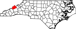
| Watauga County | 189 | Boone | 1849 | Ashe County, Caldwell County, Wilkes County, and Yancey County | The Watauga River, which came from a Native American word meaning "beautiful water" | 42,695 | 313 sq mi (811 km²) |

|
| Wayne County | 191 | Goldsboro | 1779 | Dobbs County Originally named Glasgow County |
Anthony Wayne (1745–1796), a general in the American Revolutionary War | 113,329 | 557 sq mi (1,443 km²) |
|
| Wilkes County | 193 | Wilkesboro | 1778 | Surry County | John Wilkes (1725–1797), an English radical, journalist and politician | 65,632 | 760 sq mi (1,968 km²) |

|
| Wilson County | 195 | Wilson | 1855 | Edgecombe County, Johnston County, Nash County, and Wayne County | Louis D. Wilson, a state legislator from Edgecombe County who died of fever at Veracruz during the Mexican-American War | 73,814 | 374 sq mi (969 km²) |
|
| Yadkin County | 197 | Yadkinville | 1850 | Surry County | The Yadkin River | 36,348 | 337 sq mi (873 km²) |

|
| Yancey County | 199 | Burnsville | 1833 | Buncombe County and Burke County | Bartlett Yancey (1785–1828), a United States Congressman, Speaker of the North Carolina Senate, and early advocate for the North Carolina Public School System | 17,774 | 313 sq mi (811 km²) |
 |
Map
Historic counties
| County | Created | Abolished | Fate |
|---|---|---|---|
| Albemarle County | 1664[6] | 1689[6] | Partitioned into Chowan County, Currituck County, Pasquotank County, and Perquimans County |
| Bath County | 1696[7] | 1739[7] | Renamed as Craven County |
| Bute County | 1764[8] | 1779[8] | Partitioned into Franklin County and Warren County |
| Dobbs County | 1758[9] | 1791[9] | Partitioned into Greene County, Lenoir County, and Wayne County |
| Tryon County | 1768[10] | 1779[10] | Partitioned into Lincoln County and Rutherford County |
See also
- List of cities, towns, and villages in North Carolina
- List of former United States counties
References
- General
- Corbitt, David Leroy. The Formation of the North Carolina Counties, 1663-1943. Raleigh: State Dept. of Archives and History, 1950. Reprint, Raleigh: Division of Archives and History, North Carolina Dept. of Cultural Resources, 1987. ISBN 0-86526-032-X
- Powell, William S. The North Carolina Gazetteer. Chapel Hill: University of North Carolina Press, 1968. Reprint, 1985. ISBN 0-8078-1247-1
- Specific
- ↑ "How Many Counties are in Your State?". Click and Learn. Retrieved on 2007-06-02.
- ↑ 2.0 2.1 "EPA County FIPS Code Listing". US Environmental Protection Agency. Retrieved on 2008-02-06.
- ↑ 3.0 3.1 3.2 3.3 "NACo - Find a county". National Association of Counties. Retrieved on 2008-02-06.
- ↑ 4.0 4.1 "County Histories". The State Library of North Carolina. Retrieved on 2008-02-06.
- ↑ 5.0 5.1 "North Carolina QuickFacts". U.S. Census Bureau. Retrieved on 2008-02-06. (2000 Census)
- ↑ 6.0 6.1 "Historic Albemarle County North Carolina Genealogy". USGenNet. Retrieved on 2008-07-24.
- ↑ 7.0 7.1 "Historic Bath County North Carolina Genealogy". USGenNet. Retrieved on 2008-07-24.
- ↑ 8.0 8.1 "Bute Co., North Carolina GenWeb 1764–1779". RootsWeb. Retrieved on 2008-07-24.
- ↑ 9.0 9.1 "Dobbs County, NC GenWeb Archives". USGenWeb. Retrieved on 2008-07-24.
- ↑ 10.0 10.1 "Tryon County, NC: 1768–1779". Gaston-Lincoln Regional Library System. Retrieved on 2008-07-24.
|
|||||
|