Liancourt Rocks
| Disputed Islands | |
|---|---|
| Liancourt Rocks Other names: Dokdo, Takeshima |
|
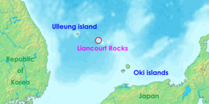 Location of the Liancourt Rocks in the Sea of Japan (East Sea) between South Korea and Japan |
|
| Geography | |
 |
|
| Location | Sea of Japan (East Sea) |
| Total islands | 90 (37 permanent land) |
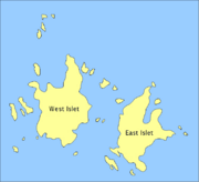
| Major islands | East Islet, West Islet |
| Area | 0.18745 square kilometres (46.32 acres) East Islet: 0.0733 square kilometres (18.1 acres) West Islet: 0.08864 square kilometres (21.90 acres) |
| Highest point | unnamed location on West Islet 169 metres (550 ft) |
| Administered by | |
| County | Ulleung County |
| Claimed by | |
| Town | Okinoshima |
| County | Ulleung County |
| Demographics | |
| Population | 2 + 43 support personnel (in rotation) |
| Ethnic groups | Korean |
The Liancourt Rocks, also known as Dokdo or Tokto (독도/獨島, literally "solitary island") in Korean or Takeshima (竹島? literally "bamboo island") in Japanese,[1] are a group of small islets in the Sea of Japan (also called East Sea). Sovereignty over the islets is disputed between Japan and South Korea.[2] South Korea has controlled them since July 1954.[3] The Franco-English name of the islets derives from Le Liancourt, the name of the French whaling ship whose crew almost crashed on the rocks in 1849.[4]
The Liancourt Rocks are comprised of two main islets and 35 smaller rocks. Their total surface area of the islets is 0.18745 square kilometres (46.32 acres), with the highest elevation of 169 metres (550 ft) found at an unnamed location on the west islet.[5] Two Korean citizens, an octopus fisherman and his wife, are the only permanent residents of the islets. A small Korean police detachment, administrative personnel and lighthouse staff are rotated through non-permanent support positions on the islets.[6]
South Korea administers the islets as Dokdo-ri,[7] Ulleung-eup, Ulleung County, North Gyeongsang Province. Japan classifies them as part of Okinoshima, Oki District, Shimane Prefecture.
The islets lie in rich fishing grounds which could also contain large gas deposits.[8]
Geography

The Liancourt Rocks are composed mainly of two islets, West Islet (西島 서도) and East Islet (東島 동도), 150 metres apart.[5] The West Islet is the larger of the two islets.
Altogether, there are about 90 islets and reefs,[9] volcanic rocks formed in the Cenozoic era.[10] A total of 37 of these islets are recognized as permanent land.[9]
The total area of the islets is about 187,450 square metres (46 acres), with their highest point at 169 metres on the West Islet (554 ft).[5] The West Islet is about 88,640 square metres in area (22 acres); the East Islet is about 73,300 square metres (18 acres).[9]
The West Islet consists of a single peak and features many caves along the coastline. The cliffs of the East Islet are about 10 to 20 metres high. There are two large caves giving access to the sea, as well as a crater.[10][11]
In 2006, a geologist reported that the islets formed 4.5 million years ago and are quickly eroding.[12]
Distance, elevation, and visibility
Liancourt Rocks are located at about 131°52´ East longitude and about 37°14´ North latitude.[9] The West Islet is located at and the East Islet is located at .
Liancourt Rocks are 217 km (135 mi; 117 nm) from mainland Korea and 250 km (150 mi; 135 nm) from Japan proper.[5] Distance, elevations, and weather conditions all affect visibility; a mathematical formula defines the numerical limits of visibility.
-
- D = 2.09 x (sqrt H + sqrt h)
where D is visible distance (nm), H elevation of landscape observed (m), and h elevation of observer's eyes (m). [13] [14]
The nearest Korean island, Ulleung-do, is 87 km away (54 mi; 47 nm), from which Liancourt Rocks are visible on a clear day in the absence of fog in the vicinity of Liancourt Rocks. [15] [16] The nearest Japanese island, Oki Islands, is 157 km away (98 mi; 85 nm), from which Liancourt Rocks are not visible on any day of the year regardless of weather conditions. [17] [18] [19]
Climate
Due to their location and extremely small size, the Liancourt Rocks sometimes have harsh weather. At times, ships are unable to dock because of strong northwestern winds in winter.[5][11] Overall, the climate is warm and humid, and heavily influenced by warm sea currents. Precipitation is high throughout the year (annual average—1324 mm), with occasional snowfall.[11] Fog is also a common sight. In the summer, southerly winds dominate.[11] The water around the islets is about 10 degrees Celsius in spring, when the water is coolest. It warms to about 25 degrees Celsius in August.[11]
Ecology
The islets are volcanic rocks, with only a thin layer of soil and moss.[9] About 80 species of plants, over 22 species of birds, and 37 species of insects have been recorded on the islets, in addition to the local maritime life.[5] Although the islets might appear rather small to support a significant flow of fresh water, and existing spring water are not fit for human consumption due to guano contamination, several springs producing potable water have been located recently. In the early 1970s trees and some types of flowers were planted.[5] In historical times, however, there used to be indigenous trees on Liancourt Rocks according to historical records, which disappeared due to human harvesting. Trees are required under international law for the islets to be recognized as natural islands rather than reefs.[6] [11]
Demographics
There are two permanent Korean citizens, Kim Sung-do (김성도) and Kim Shin-yeol (김신열), living on the islets. In addition to these residents, there are 37 South Korean police officers (독도경비대/獨島警備隊) who take residence on guard duty. There are also three Ministry of Maritime Affairs and Fisheries personnel, and three lighthouse keepers living on the islets in rotation. In the past, several fishermen also lived on the islets temporarily.[6] For many years, civilian travel was subject to Korean government approval because the islet group is designated as a nature reserve. Tourist boats carrying 1,597 visitors were allowed to land in 2004. Since mid-March 2005, more tourists have been allowed to land, up to 70 tourists are permitted at any one time. Tour companies charge around 350,000 Korean won per person.[6]
International dispute
Currently, both South Korea,[20][21] and Japan[22] are claiming sovereignty over Liancourt Rocks. There are conflicting interpretations about the state of sovereignty over the islets in pre-modern times. Korean claims are partly based on references to a Korean island called Usan-do (우산, 于山島/亐山島) in various historical records, geographies, maps, and encyclopedia such as Samguk Sagi, Annals of Joseon Dynasty, Dongguk Yeoji Seungnam, and Dongguk munhon bigo. According to the Korean view, these refer to today's Liancourt Rocks, while the Japanese views variously argue that they refer to either Juksoe (竹嶼; Korean Jukdo or Dae'soem), Kwanumdo (관음도, 觀音島, 島項; Korean Seommok, G'aksae), Ulleungdo, or a non-existent island. [23]
1696 Murakami Document
Korean historical sources state that the administrator of Tokugawa shogunate reaffirmed in January 1696 that Ulleungdo and Dokdo belonged to Korea quoting An Yong-bok's testimony.[24][25][26] The dispute about the ownership of Ulleung-do between Chosun Korea and Tokugawa Japan ignited when Korean fishermen clashed with Japanese fishermen on Ulleungdo waters in 1692. The following year, An Yong-Bok and Park Eo-dun, representing Korean fishing communities, are variously said to have visited, drifted, or even abducted by Japanese fishermen, arriving at Oki island in 1693. Taking this occasion, An discussed territorial title matters with a Japanese governmental official, reminding him that Ulleungdo and Jasando(자산도, 子山島 sic; a scribal corruption of Usan-do 于山島/亐山島) are Korean territory. As a result, the bakufu issued prohibitions banning Japanese fishermen from travelling to Ulleng-do. This is called the 1st An Yong-bok incident.

An, on being released from a two-year exile on charges of traveling to a foreign country without permission, made a second trip to Japan together with a group of Koreans from Dongnae and other maritime regions in 1696 with documents and a map to reconfirm his initial claim during the first confrontation, which had come under suspicion by the Korean government due to the Tsushima clan's delaying Edo's orders to notify the Korean government of Japan's prohibition to travel to Ulleungdo. Aware of the severe punishement, which the Edo government would certainy pass on the Tsushima lord, Tsushima expedited to the Korean government Edo's decision to nullify "Permission to cross to Takeshima (Ulleund-do)" which it had been witholding until An's visit. Although Japan did not mention Matsushima (Liancourt Rocks) on the prohibition papers, no Japanese could legitimately travel to either Takeshima or Matsushima until the end of the bakufu period.[27] This document from An's second trip[28] relays An's words that Ulleungdo, geographically subordinate to Gangwon province, was administered by Dongnae-bu. The document records the distance between Takeshima (Ulleungdo) and Matsushima (Liancourt Rocks) as 50 ri, and also states, in a rough copy of An's map of Korea, that the two islets belonged to Korea's Gangwon province. In the Annals of King Sukjong, the official governmental chronicle, An is reported to have stated that Jasan-do 子山島(sic) was what the Japanese called Matsu-shima 松島 at that time. [29]
1697 Korean court's decision to disregard Tsushima's request of a formal letter for Edo
In Feb 1697, the Korean government reached a decision to reject Tsushima clan's request to emend a previous letter that mentioned Korea's Ulleungdo, and that An Yong-Bok's visit to Japan to raise a legal case does not require a written response from Korea since the Royal Court had no foreknowledge. These facts were to be conveyed to the Tsushima envoy's house informally: "An was an unenlightened subject who got thrown about by a storm. If he executed something, it had not been known by the Joseon Royal Court."[30] [31]
In March, 1969, the Korean government made a formal communication in writing that An was punished for submitting a legal case against the governor of Hokishu to the Edo government without authorisation from the Korean government."[32]
Although the Border Defense Command demanded capital punishment, King Sukjong commuted An's sentence to exile in positive consideration of his successful negotiations with the Edo government that resulted in the "prohibition of all Japanese travelling to Korea for fishing, harvesting, and lumbering for eternity". [33] [34] [35]
1785 Map of Three Adjoining Countries

A Japanese scholar of practical science Hayashi Shihei published 『Map of Three Adjoining Countries』(三國接壤地圖)in 1785, which showed each country in distinct colors; Joseon (old name of Korea) in yellow, Japan in green. In it, Uleungdo and a small islet in the middle of the East Sea were not only colored in yellow but marked, "As Korean territories (朝鮮ノ持ニ)".
1877 Daijō-kan order to exclude Takeshima (Ulleungdo) and another island from Japanese National Land Registry
On March 20, 1877, the Japanese Supreme Council Daijō-kan issued an order[36] stating that Ulleungdo (then called "Takeshima 竹島", now called Matsushima 松島 by Japan) and another island (外一島) are not under Japanese rule [37] [38]. Korea claims that "another island" (外一島) besides Ulleungdo refers to Liancourt Rocks [39] [40] [41] and considers this order as an evidence that Liancourt Rocks was under the control of Korea. The Japanese government has not made any comment on this point whereas some Japanese consider that "another island" (外一島) does not refer to Liancourt Rocks.[42] [43]
1900 Korean Imperial Decree No. 41 separates Uldo Archipelago from Uljin County
In the year 1900, Korea issued Imperial Decree No. 41 of Oct 25, 1900, which included the following administrative actions.
-
- Ulleungdo, which had been subordinate to Uljin Prefecture[44] since the reign of King Sejong, shall be renamed Uldo and elevated to county.
- Uldo County office shall rule over all of Uldo proper and its dependencies including Jukdo and Seokdo.
The decree was published in Official Gazette No. 1716 (관보 제1716호) on Oct 27 and distributed to the international community, including Imperial Japan, with representations in Seoul.[45] [46] [47]
This decree states that Ulleungdo be renamed to Uldo (mod. Ulleungdo), and that the county hall shall govern the whole island of Ulleungdo, Jukdo, and Sokdo. [48] [49] Japan claims that there is no evidence to identify the island "Sokdo" as Liancourt Rocks, [50] [51] and that there is no record that proves the effective occupation by Korea before Japanese Cabinet decision of Jan 28, 1905. Korea claims that the island "Sokdo" mentioned in this document is Liancourt Rocks, and thus Liancourt Rocks was still officially part of Korea as an ancient territory since 512. Korea presents evidence that Koreans living on Ulleungdo referred to Liancourt Rocks as Dokseom (or Dolseom; literally "rocky island") in speech and Dokdo 獨島 in writing as a phonetic transcripton (音讀, umdok; 音読み on-yomi), while the name "Seokdo" 石島 ("rocky island") in the Ordinance was an instance of logographic translation (訓讀, hundok; 訓読み kun-yomi). [52] [53] [54]
Korea also claims Liancourt Rocks was effectively managed by seasonal fishermen and divers in recent times [55] as a result of King Gojong's Ulleungdo Reclamation Program (鬱陵島開拓令) issued in Dec 1881. A first-person account by one of the fisrt settlers since the reclamation program has been presented as one evidence to the fact of the claim. [56] A South Korean scholar claims to have uncovered evidence that Korean fishermen effectively occupied engaged in "whaling" in Liancourt Rocks waters in the 1880s and that sea lions were hunted and sea-lion-derived products were exported to Japan in 1904 prior to the Japanese Cabinet decision of 1905 to incorporate a supposed terra nullius. [57]
1904 Japan-Korea treaty
The Japan-Korea Protocol of 1904 signed between Japan and Korea on February 23, 1904 (Japanese 日韓議定書, Nikkan Giteisho; Korean 韓日議定書, 한일의정서, Han'il uijongso) stipulates in article 3 that Japan shall guarantee the territorial integrity of Korea. It further stipulates in article 4 that, in case the territorial integrity of Korea is endangered by aggression of a third power, Korea shall give full facilities to promote the action of Japan, and that Japan may occupy, when the circumstances require, such places as may be necessary for strategic reasons.
Article 4 of the treaty has been quoted as giving Japan full authorisation in terms of international law in taking Liancourt Rocks as a strategic surveillence point during the Russo-Japanese War.[58] [59] [60] Article 3, however, has been quoted as preventing Japan from appropriating Liancourt Rocks post bellum, and hence ruling the 1905 Shimane incorporation illegal after the end of the war. [61] [62] Although the watch tower on Liancourt Rocks was demolished, suggesting the necessity on strategic resaons had disappeared, the Japanese Cabinet decision to incorporate Liancourt Rocks had not been revoked in violation of the treaty. This suggests foreign military threat from a third country in Article 4 was not the primary ground of incorporating Liancourt Rocks, [63] but its own violence and greed that Japan is expected to disprove with prima facie evidence in the manner of which the act of incorporation was committed. [64]
1905 Japanese Incorporation of Liancourt Rocks
The imperial government of Japan incorporated Liancourt Rocks as a result of a Cabinet decision in early 1905. Three motives are commonly cited for it cause: civilian occupation of said islets by a Japanese citizen from Oki, Nakai Yozaburo (中井養三郎; 1864-1934), practical necessities arising from the armed conflict with Russia, and Japan's foreign policy regarding Korea as its western frontier to fend off encroaching foreign powers. The incorporation was conducted incognito to foreign nations including Korea as the decision had never been announced by the central government to the international community. The Korean response to reports of the verbal notice by a local Japanese official was one of shock and disbelief, and orders were issued to investigate the truth of the report. While the result of the investigation is obscured in silence, apparently lending momentum to the Japanese claim, the Japanese Resident-General residing in Seoul, in 1906, makes an inquiry into which islands are administered by Ulleungdo (sic.), in the older designation before the 1900 Korean Imperial Decree No 40, to which the Internal Ministry relays facts consistent with the 1900 Imperial Decree No 41, that Uldo County administers Uldo proper, Jukdo, and Seokdo.
1903-1904 Nakai's Fishing Enterprise
On September 29, 1904, Nakai Yozaburo (中井養三郎; 1864-1934) of Saigo, Shimane Prefecture, experimenting with sea lion hunting business in the summers of 1903 and 1904, and wanting to protect his investment, submitted a petition to incorporate Liancourt Rocks and to issue exclusive license to hunt sea lions for ten years. The petition was submitted to the Home Ministry, the Ministry of Foreign Affairs, and the Ministry of Agriculture and Commerce. Nakai, initially believing Liancourt Rocks to be Korean territory, had planned to ask for a lease from the Korean government via the Ministry of Trade and Commerce. An officer of the Ministry of Home Affairs considered it unwise to incorporate Liancourt Rocks suspected to be Korean territory, but the Navy and the Foreign Ministry advised incorporation would be profitable, and that there would arise no diplomatic repercussions. [65] [66] [67] [68] [69] [70] [71]
1905 Japanese Cabinet Decision on Liancourt Rocks
Japanese government's official view has evolved since 1905. On Jan 28, 1905, the Cabinet reached a decision to incorporate Liancourt Rocks (明治三十八年一月二十八日閣議決定), on grounds that it had been a terra nullius under international law: [72] [73] [74] [75] [76] "There is no evidence to recognise that this uninhabited island was ever occupied by a foreign country... As evidenced through relevant records that a person by the name of Nakai Yozaburo (中井養三郞) has relocated to said island in 1903 (Meiji 36) and practiced fishing there since, we recognise the fact that occupation has occurred in terms of international law."[77]
From 1947 to 1954, the Japanese government's claim shifted from prior occupation of a terra nullius to effective occupation by executing state intention to acquire territory".
Not later than 1962, Japan again shifted its claim to "[the 1905] reconfirmation of title to an inherent/ancient territory", all based on Japan's changing interpretation of the same Cabinet decision document, all the while carefully avoiding its previous claim of incorporation on grounds of prior occupation of a terra nullius. [78]
Korea also claims that Japan's 1905 claim to terra nullius conflicts with its previous recognition (i.e., the 1877 Daijō-kan order) of the islets as Korean territory. [79] [80] [81]
1905 Shimane Notice 40
Japan claims to have enforced its Cabinet decision of Jan 28, 1905 to incorporate the "unclaimed" islets as part of Shimane Prefecture (島根縣) in Shimane Prefectural Notice No. 40 of Feb 22, 1905 (島根縣告示第40號) [82] [83] [84]. The decision was reported in a newspaper, San-in Shimbun, on Feb 24, 1905.[85] [86] [87] [88]
Korea claims that the decision was not reported in a official gazette. The decision was reported a one minor local newspaper only. There is no evidence that decision reported in a government gazette. Moreover, There is no evidence that decision reported to a central government of Japan at one time, also the decision was not noticed by central government. Japan was not notice to neighbor country. Korea claims that it was a almost impossible that tiny sized notice of local newspaper (3.4 cm[89][90]) recognized by foreign. Korea claims that the decision was a nothing but a "document occupation", and its procedure was a secret. Therefore, Korea claims that the decision was not fulfil the necessary conditions of territory's incorporation by international law. [91] [92] Korea also claims that 'Shimane Notice 40' was not announced to public. [93]
The incorporation came in the heat of the Russo-Japanese War and before the Eulsa Treaty of November 17, 1905, when Korea became Japan's protectorate. A temporary watchtower was erected on the islets for anti-Russian surveillance purposes, which was demolished after Japan's victory in the war.
1906 Verbal Notification of Incorporation and Korean Response
Japanese claims the incorporation was legitimate in that Korea did not dispute the incorporation when the news was published. Korea claims the incorporation was invalid in that the Feb 24 San-in Shimbun report lacked official status as its circulation was limited to the Shimane prefectural region. Korea claims neither the decision of the Japanese Cabinet, the order of Ministry of Home Affairs, nor the Shimane Notice had been announced, until March 28, 1906, to the Korean government to which many Japanese, including petitioner Nakai Yozaburo (中井養三郞) and certain governmental officials believed the title of Liancourt Rocks belonged.
On that date, a party of 44 officials from Shimane Prefecture visited Ulleungdo. The Japanese officials, including Kanda Yoshitaro, traveled to Ulleungdo by way of Dokdo, and informed Sim Heung-taek, then Magistrate of Ulleungdo, that Dokdo had been incorporated into Japan.
Stunned by this announcement, Sim sent word, the next day to Yi Myeong-nae, then Governor of Gangwon Province. Yi, in turn, recognizing the urgency and gravity of the matter, forwarded the report to the State Council Minister of the Korean Empire.
State Council Minister Bak Je-sun, in Directive No. 3 issued on May 20, 1906, stated, “It is totally groundless that Dokdo has become Japanese territory,” and went on to order “an investigation and report on the situation and on what the Japanese have done.”[94] The Eulsa Treaty stripped Korea of all its diplomatic rights on 17 November 1905.[95][96] Five years later, Korea was fully annexed by Japan.
1906 Communication between Japanese Resident-General and the Korean Government
A curious inquiry and reply are exchanged between Japanese and Korean officials, the result of which is reported in July 13 edition of Hwangseong Shinmun. In the letter, says the report, the Japanese Resident-General asks which islands are administered by Ulleung Is. The Korean Home Ministry simply lists the same islands as in the 1900 Decree specifying Seokdo, which Korea claims to be Liancourt Rocks. It also adds a physical measurement of what is believed to be Ulleung Is.[97] [98] [99] [100]
The Japanese inquiry is not current with the 1900 Korean Decree in its inaccurate designation of place names and offices, while the Korean reply remains silent on the rumour of incorporation of Liancourt Rocks of which it had not been officially notified. The details of the reasons for the Resident-General's inquiry and the Korean government's judgement regarding the inquiry are not known. [101] [102]
Prior to the Resident-General's inquiry and the Korean government's response reported on July 13, daily newspapers Hwangseong Shinmun (May 9, 1906) and Daehan Maeil Sinbo (May 1, 1906) had denied the rumoured Japanese local official's claim of incorporating Liancourt Rocks. "their claim to Dokdo as Japanese territory is totally groundless; the story is really shocking." [103] Although Hwangseong Shinmun had clearly declared that rumours of the Japanese incorporation of Liancourt Rocks were baseless two months before the July communication[104], and although the July communication reminded the Resident-General, Itou Hirobumi, of the 1900 Imperial Decree reaffirming Korea's state authority over Liancourt Rocks, there is no evidence that the then Resident-General or any other representation of Imperial Japan raised a formal objection to it.
1920 Provisional Government of the Republic of Korea in exile
In a memorial speech at the first anniversary of the 1919 March 1st Movement, Prime Minister Yi Dongnyeong accused Japanese government's illegal incorporation of Liancourt Rocks of 1905. [105]
Post World War II era
The recent dispute stems largely from conflicting interpretations of whether Japan's renunciation of sovereignty over its occupied territories after World War II was supposed to cover the Liancourt Rocks as well.
Supreme Commander of the Allied Powers Instruction #677 of January 29, 1946, listed the Liancourt Rocks, along with many other islands, as part of those territories over which Japanese administration was to be suspended.[106] In the first to fifth drafts of the Treaty of San Francisco between Japan and the Allied powers, Liancourt Rocks was described as part of Korea.
The sixth and seventh drafts, made on Dec 29, 1949, and Aug 7, 1950, respectively, ruled that Liancourt Rocks belonged to Japan.
The U.K. draft and the attached map[107] reflecting the view of Commonwealth nations[108] submitted April 7, 1951, excluded Liancourt Rocks from Japanese territorial definition and placed Liancourt Rocks within Korean territory:
- "Japanese sovereignty shall continue over all the islands and adjacent islets and rocks lying within an area bounded by a line ... bearing north-easterly between ... the islands of Oki-Retto to the south-east and Take Shima to the north-west".
Finally, the U.K. agreed to the US style of the treaty excluding the islands of Quelpart, Port Hamilton and Dagelet from Japan. [109]
The final version left the territorial title of Liancourt Rocks undefined between Japan and signatory states.
- Article 1
- (b) The Allied Powers recognize the full sovereignty of the Japanese people over Japan and its territorial waters.
- Article 2
- (a) Japan recognizing the independence of Korea, renounces all right, title and claim to Korea, including the islands of Quelpart, Port Hamilton and Dagelet.
Korea claims that its territorial title to Liancourt Rocks was returned to Korea with the surrender of Japan which was enforced by Supreme Commander for Allied Powers' prohibitions suspending Japanese access to within 12 miles (19 km) from said island [110] which needs to be explicitly revoked in order to effect a change [111]. Such a change modifying the status of Liancourt Rocks has never occurred before "SCAP transferred its jurisdiction... to the United States Army Military Government in Korea on January 29, 1946." The U.S. Military Government in Korea, in turn, reverted all jurisdiction over Liancourt Rocks to the Government of South Korea when it launched on August 15, 1948.[112] South Korea's President Rhee Syngman's announcement of the Peace Line enforced Korea's territorial title to Liancourt Rocks.
US's recognation about this format of treaty was Japan recovered full sovereignty under article 1 except islands which were excluded from Japan by name. [113]
Early Japanese efforts to claim Liancourt Rocks and Ulleung Island
Both countries submitted petitions and documents to pursuade the Allied Powers to rule Liancourt Rocks in their favour. The Japanese government's Foreign Office submitted a series of documents, issued from November 1946 to June 1947, entitled Minor Islands Adjacent to Japan Proper; Parts I-IV, of which Part IV, Minor Islands in the Pacific, Minor Islands in the Sea of Japan described Utsuryo-shima (Ulleungdo) and Take-shima (Dokdo, Liancourt Rocks) as Japanese territory. [114] [115] [116] [117] [118] This document largely based on material prepared by Kawakami Kenzo 川上健三, the then treaties expert for the Japanese Foreign Office, argued for the Japanese title to Dagelet Is and Liancourt Rocks in the following words [119]:
-
- Chapter II. Minor Island in the Japan Sea [120]
-
- Introduction
-
- "Liancourt Rocks and Dagelet Is lie off the Tsushima Strait [are] some 50 miles (80 km) apart."
- "The existence of these islands was known to Japan in early times."
- The Japanese names for these two islands were reversed due to the cartographic error of a German Dutch physician Philipp Franz von Siebold. [121]
- I. Liancourt Rocks (Take-shima)
-
- 1. Geography
-
- Liancourt Rocks are 86 miles (138 km) from Oki Islands of Shimane Prefecture.
- 2. History
-
- "[T]he Japanese knew the existence of the Liancourt Rocks from the ancient times."
- "The earliest documentary evidence is Inshu Shicho Goki" of 1667.
- "While there is a Korean name for Dagelet, none exists for the Liancourt Rocks."
- "They are not shown in the maps made in Korea."
- 3. Industry
-
- "It is presumed no one has ever settled on the islets."
- "In 1904, the inhabitants of Oki islands began to hunt sea-lions on these islets."
- "[E]ach summer, the islanders, using Dagelet as their base, went regularly to the Rocks and built sheds as temporary quarters for the season."
- II. Dagelet Island (Matsu-shima, Utsuryo or Ul-lung Island)
-
- 1. Geography
-
- "Dagelet Island is equidistant from the port of Fushan (Busan) and the port of Sakai of Tottori Prefecture of Japan."
- "The flora of this island... is recognized to have many common features with Japan Proper."
- "The cultivation in Japan of the Take-shima lily (lilium hansonii), an indemic plant of the island, is mentioned in a book published in 1710, a fact which points to an early intercourse between the island and Japan."
- 2. History
-
- In Japanese documents... reference was made as early as 1004 to Uruma Island, an old Japanese equivalent for Ul-lung Island."
- "The Korean Government from 1400 and onward adhered for a long time to a policy of keeping it uninhabited...the island was thus virtually abandoned by the Korean Government."
Many of these claims, regardless of their historical verity, and without critical historical review [122], were emphasised by William J. Sebald, the then political advisor for SCAP in Tokyo, which eventually had a strong formative influence on the position maintained by the Diplomatic Section of SCAP and the US State Department regarding the territorial aspect of the Peace Treaty. [123] [124]
Educated neither as an historian nor a geographer, Kawakami Kenzō (川上健三?) went on to build on this early investigation supporting the Japanese claim in a work called An Historical and Geographical Study of Takeshima (竹島の歴史地理学的研究 Takeshima no Rekishi Chirigakuteki Kenkyū?)[125] for the Japanese Ministry of Foreign Affairs published in 1966, in which he added such claims as:
-
- Koreans on Ulleungdo could not see Dokdo, due to the heavy forestation on Ulleungdo
- Koreans were not aware of the Liancourt Rocks before the 20th century, as seen in the lack of documents pertaining to the Liancourt Rocks
- Koreans did not have adequate naval navigation to reach Dok-do/Takeshima
While such adherents as Shimojo Masao, Tanaka Kunitaka, and Gerry Bevers have presented arguements essentially building on Kawakami's old claims, many of the claims, old and new, have been disproved as spurious by both Korean and Japanese scholars.
-
- Visibility of Liancourt Rocks from Ulleungdo is attested in history [126] [127] [128] [129], in theory [130] [131] and from observation [132].
- Koreans already possessed the skills to reach Ulleung-do from mainland Korea since not later than the 6th century. [133]
- Koreans transmitted advanced shipbuilding/navigational technology to the Japanese from early historical times. [134] [135] [136]
Early Korean efforts to claim Liancourt Rocks as an Appendage/Dependency to Ulleung Island
A corresponding Korean effort came from a private organisation self-styled "Patriotic Old Men's Association" led by a former military leader of the Korean Government in Exile, Cho Sung Hwan, on August 5, 1948, ten days before the inauguration of the South Korean government.[137] [138] [139]
They petitioned for the sovereignty of Docksum (Liancourt Rocks), Ullung Do, Tsushima and Parang islands [140] [141] The Headquarters of the Patriotic Men's Association made the following statements to back up Korea's claim to sovereignty over Ulleung Is and Liancourt Rocks:
-
- Request for Arrangement of Lands between Korea and Japan
- I. Returning ... the island "Docksum."
-
- "'Ulneungdo' and its attached ... belong... to Korea historically."
- "Japan planned to profit by fishing and foresting under the evacuation policy."
- "Resolute negotiation... Japan acknowledged their fault and made a word to prohibit to fish there in 1693."
- "Since 1881, Japan began to reinvade... Under the negotiations in Tokyo... by plenipotentiary Suh Sang Woo and ... advisior G. von Mollendorf, Japan surrendered to Korea."
- Japan, never dismiss[ing] the fishing profit around Ulneungdo, ... planned to occupy a corner of it... and became to find out a small island called 'Docksum'... near the Ulneungdo, where whales gathered."
- "In 1904, Japanese fishere of Tottoriken named Nakai Yosaburo made a cruel programm to seize the Docksum and was practised to submit petitions or requets to the hydrographic department of Navy, Dep't of Home Affairs, Dep't of Foreign Affairs and Dep't of Agriculture and Commerce... to register the island into Japanese territory."
- "The so-called Takeshima is the very 'Dockusum (sic) in Korean name."
- "This is namely Liancourt Rocks on the world's chart."
- "This name "Liancourt-Rocks" was established due to the name of the French whaler which found... the island. Thereafeter, by the Russian warship 'Paleada' ion 1854, and by the English warship "Hornet" in 1855, the said island was re0found and the ship's name was given to it."
- "But it was never suspected that these variously named island was the very island "Ulneungdo."
- "It is ... said that a Japanese district office carried out such a plan imposing upon the world."
- "Such an island occupied illegally by Japan should be returned to Korea."
The document's clear identification of Liancourt Rocks with the Korean "Docksum" in the vernacular language is not noted by William Sebald, whose office relayed a facsimile copy to the US State Department. The document is unique in its logical treatment of Liancourt Rocks as an appendage/dependency [142] to Ulleung Is as can be seen in the statement: "these variously named island was the very island 'Ulneungdo'" although some scholars believe the prerequisite to unity theory needs a qualification before it can be applied to the case of Liancourt Rocks.[143]
First US bombing incident over Liancourt Rocks
The US designated Liancourt Rocks as a bombing range(SCAPIN #1778), and notified Japanese government on September 16, 1947. On June 8, 1948, twenty-nine US B-29 bombers from Kadena, Okinawa, flew over Liancourt Rocks in a bombing excercise dropping seventy-six bombs causing civilian casualties. [144] The South Korean government announced 16 civilians were killed by the US military drill, higher estimates run up to twenty times that figure, i.e. 320. [145]
One researcher estimates damages somewhere between 30 and 80 fishing boats and civilian deaths between 30 and 100. [146] [147]
Classified US communication to Korean Government
On Aug 10, 1951, a secret correspondence currently known as Rusk documents was sent to South Korea communicating the then U.S. position on issues of territorial sovereignty in the Peace Treaty explaining why the US believed Liancourt Rocks were Japanese territory: "[T]his normally uninhabited rock formation was according to our information never treated as part of Korea and, since about 1905, has been under the jurisdiction of the Oki Islands Branch Office of Shimane Prefecture of Japan. The island does not appear ever before to have been claimed by Korea."
Korea announces state intention to resume administration
On January 18, 1952, South Korea, a non-signatory state to the San Francisco Peace Treaty, announced the Presidential Declaration of Sovereignty over Adjacent Seas (Peace Line, Rhee Line) including Liancourt Rocks within Korean territory along the expiring MacArthur Line (SCAPIN#1033; June 22, 1946 - April 1952) before the Peace Treaty came into force on April 28.
On July 18, 1952, South Korea issued a presidential order to seize all illegal foreign vessels engaging in fishing in breach of the Peace Line.
Japanese MOFA acknowledges intention behind bombing range designation
On May 23, 1952, in a Foreign Affairs committee meeting held in the House of Representatives, Ishihara, Vice-minister of Foreigner Affairs acknowledged MOFA's intention regarding the designation of Liancourt Rocks as bombing range for Occupation Forces in response to a question raised by Yamamoto, a Diet member from the Shimane constituency: "[To] help Japan get confirmation of its territorial sovereignty over the island." [148]
Second US bombing incident over Liancourt Rocks raises doubts
On September 15, 1952, a South Korean scientific expedition aboard Chinnam-ho and a fishing crew of 23 aboard Kwangyong-ho were attacked on Liancourt Rocks waters by a mono-propellered aircraft bearing the US insignia that disappeared in the direction of Japan after dropping four bombs. The South Korean Navy had initially submitted an itinerary to the United Nations Naval Commander in Busan (CTG 95.7) on Sept 7 of the expedition to visit Ulleungdo Island and Liancourt Rocks 14th and 15th of September. Granted approval to travel to said areas by CTG 95.7, the expedition departed Busan on Sept 12 unaware of the United States-Japan Joint Committee's bombing plan over Liancourt Rocks for Sept 15.[149]
In response to the bombing incident, the US Embassy to Japan in Tokyo transmitted a message including the following on October 3, 1952, to the US State Department, "The history of these rocks has been reviewed more than once by the Department, and does not need extensive recounting here. The rocks, which are fertile seal breeding grounds, were at one time part of the Kingdom of Korea. They were, of course, annexed together with the remaining territory of Korea when Japan extended its Empire over the former Korean State... There exists a fair chance that... American bombs may cause loss of life... which will bring the Korean efforts to recapture these islands into more prominent play, and may involve the United States unhappily in the implications of that effort." [150]
US State Department answered to US Embassy Korea and Tokyo on Nov 14, 1952,"It appears that the Department has taken the position that these rocks belong to Japan and has so informed the Korean Ambassador in Washington.[...]it did not appear that they had ever before been claimed by Korea. As a result Article 2(a) of the Treaty of Peace with Japan makes no mention of the Liancourt Rocks."
Finally, US government kept the understanding of Rusk notes, and US Embassy Korea sent a diplomatic document to Korea government on Dec 4, 1952, "The Embassy has taken note of the statement contained in the Ministry's Note that'Dokdo Island (Liancourt Rocks) .....is a part of the territory of the Republic of Korea.'The United States Government's understanding of the territorial status of this island was stated in assistant Secretary dated August 10,1951." .
US downplays its support for Japan's sovereignty over Liancourt Rocks, declines to interfere in the dispute
On Dec 9, 1953, the US Secretary of State John Foster Dulles cabled the American Embassy in Tokyo, "US view re Takeshima is simply that of one of many signatories to the treaty. The U.S. is not obligated to 'protect Japan' from Korean "pretensions" to Dokdo, and that such an idea cannot...be considered as a legitimate claim for US action under the U.S.-Japan security treaty."" [151] [152]
In 1954, James Van Fleet, a US special mission ambassador, submitted a secret report after a round of visits to South Korea, Japan, Taiwan, and the Philippines, to the U.S. President Dwight Eisenhower. The The Report of Van Fleet mission to the Far East summarised: "[T]he United States concluded that they remained under Japanese sovereignty and the Island was not included among the Islands that Japan released from its ownership under the Peace Treaty ... Though the United States considers that the islands are Japanese territory, we have declined to interfere in the dispute.""
Proposal to settle before ICJ rejected
In September 1954 and March 1962, Japan proposed to South Korea that the dispute be referred to the International Court of Justice. South Korea has rejected the proposal.
Sebald predicts negative outcome in Japan's bid for UNSC action, but advises legal counsel
On November 17, 1954, Japanese Embassy Minister Shigenobu Shima asked William Sebald, the Deputy Assistant Secretary of Far Eastern Affairs, and Mr. R. B. Finn, Officer in Charge of Japanese Affairs at the State Department, Washington D.C., whether the U.S. would support Japan in the Security Council if it submited the dispute with the ROK over Liancourt Rocks.
William Sebald responded, "I have personally followed this controversy over a long period of time... although Japan is free to do as it thought best in presenting its case, the Security Council would probably want to see that all bilateral efforts have been exhausted before hearing the case." He added, "It seems that the ROK will not submit to ICJ arbitration regardless of Security Council action." Sebald added, "It is important for Japan to keep its claim alive and not to permit its rights to be prejudiced by default... A note to the ROK or other periodic formal statements would serve this purpose." [153]
When Embassy Minister Shigenobu Shima asked whether this constituted US recognition of the validity of Japan´s claim, Sebald responded, "US relations with the ROK had recently improved," noting, "The US-ROK Mututal Defense Treaty is being brought into force on November 17...The general understanding had been agreed to in Seoul."[154]
The current U.S. government stands on a neutral position on this issue.
Recent conflict
On July 14, 2008, South Korea temporarily recalled its ambassador to Japan,[155] after Japanese government decided to mention the dispute over the islands in the "Commentary to the Curriculum Guideline" (学習指導要領解説 Gakushu sido yōryō kaisetsu?) for social study classes in junior high school.[156] The Korean Coast Guard strengthened its early warning system as a preventative measure against any possible attempt by Japanese right-wing groups to land on the islets.[157] On July 18th, there was a protest in front of the Japanese embassy in Seoul.[158][158][159] The Korean government is considering sending marines to replace a police contingent on Dokdo to thwart Japan's territorial claim to the islets.[160]
Prime Minister Han Seung-soo expressed strong dissatisfaction for Japan's Education Ministry[161] The Korean government is also considering building infrastructure to provide tap water, establishing an oceanic scientific base, dispatching public officials to the area, allowing freer public access to the islets, and turning Dokdo into a resort area with hotels.[161] Korea rejected a Japanese offer for a bilateral meeting on the sidelines of the annual ASEAN regional security summit in Singapore.[162] Japan's Chief Cabinet Secretary expressed concern that military tensions would escalate.[162]
In July 2008, the U.S. Board on Geographic Names (BGN) changed the name of the country that Liancourt Rocks belong to from South Korea to Undesignated Sovereignty. Responding to this change, Gonzalo R. Gallegos, Acting Deputy Spokesman of the U.S. State Department, said on July 28, 2008 that the United States has long maintained a policy stance of neutrality on the islets, and that the latest change does not represent any policy change within the U.S. government.[163]
The same change that classified Liancourts Rocks as Undesignated Sovereignty in the BGN database was reversed on July 30th under the order of U.S. President George W. Bush, once again marking the status of Liancourts Rocks under South Korean control.[164][165][166][167][168]
Appearance in Chinese records
In 1488, Dong Yue, a Chinese fonctionnaire and diplomat, wrote a memoir of his Korean journey in a fu epic called A Fu on Korea, Chao Xian Fu,(Chinese 朝鲜赋). A 1717 Japanese facsimile manuscript recently rediscovered includes a map of Korea, Joson paldo chongdo, which shows the islands of Ulleung (Dagelet Is.) and Usan (Liancourt Rocks) as Korean territory. [169]
See also
- Korea under Japanese rule
- Japan-Korea Annexation Treaty
- Japan-Korea relations
- Japan-South Korea Joint Declaration of 1998
- Japanese-Korean disputes
- List of war apology statements issued by Japan
- Japanese history textbook controversies
External links
- The Issue of Takeshima, Japanese Ministry of Foreign Affairs
- Takeshima Shimane Prefectural Government
- The Truth of Dokdo : Response to 『10 Issues of Takeshima』by Northeast Asian History Foundation ①,②
- The History of Dokdo(Feb, 10, 2007), Northeast Asian History Foundation
- Korea's Dokdo: Past and Present Korean Embassy to USA
- Dokdo: Korean Territory Since the Sixth Century Korean Embassy to USA (pdf)
- Story of Dokdo by Dokdo Research and Preservation Association and Dokdo Institute (pdf)
- Dokdo studies in English for researchers by Dokdo Institute/Shin Yong-Ha
- Selected Research on Dokdo Island by Mark Lovmo
- The Historical Facts of the Dokdo Takeshima Dispute by Steve Barber
- Cyber Dokdo History Hall
- Cyber Dokdo
- BBC News Video of protest in Seoul
 Draft Treaty of Peace with Japan and Liancourt Rocks on Wikisource.
- History of and Sovereignty over Dokdo, Korea.net
References
- ↑ Staff Seoul and Tokyo hold island talks BBC, 20 April 2006
- ↑ Charles Scanlon "South Koreans vent fury at Japan" BBC Online, 18 March 2005
- ↑ "Liancourt Rocks / Takeshima / Dokdo / Tokto", Globalsecurity
- ↑ Kirk, Donald (2008-07-26). "Seoul has desert island dreams", Asia Times Online.
- ↑ 5.0 5.1 5.2 5.3 5.4 5.5 5.6 Korea.net (1999–2006). Dokdo: A Profile. Retrieved 9 January 2006.
- ↑ 6.0 6.1 6.2 6.3 Korea.net (1999–2006). Dokdo: Inhabitants and Visitors. Retrieved 9 January 2006.
- ↑ "Act 1395 amending Chapter 14-2, Ri-Administration under Ulleung County, Local Autonomy Law, Ulleung County (울릉군리의명칭과구역에관한조례 [개정 2000. 4. 7 조례 제1395호)]". "Pursuant to Act 1395 amending Chapter 14-2, Ri-Administration under Ulleung County, Local Autonomy Law, Ulleung County, passed March 20, 2000, enacted April 7, 2000, the administrative designation of Dokdo addresses as 42 to 76, Dodong-ri, Ulleung-eup, Ulleung County, North Gyungsang Province, is changed to address 1 to 37, Dokdo-ri, Ulleung-eup, Ulleung County, North Gyungsang Province." "2000년 4월 7일 울릉군조례 제1395호로 독도리가 신설됨에 따라 독도의 행정구역이 종전의 경상북도 울릉군 울릉읍 도동리 산42~76번지에서 경상북도 울릉군 울릉읍 독도리 산1~37번지로 변경 됨."[1]
- ↑ Island row hits Japanese condoms
- ↑ 9.0 9.1 9.2 9.3 9.4 Gyongsangbuk-do (2001). Cyber Dokdo. Retrieved 9 January 2006.
- ↑ 10.0 10.1 Geography of Dokdo truthofdokdo.or.kr, retrieved 2007-08-21, 'Dokdo is composed of alkaline effusive rocks which erupted during the Cenozoic Era. Dokdo began to form about 4.6 million years ago'
- ↑ 11.0 11.1 11.2 11.3 11.4 11.5 Truth of Dokdo. Story of Dokdo. Retrieved 9 January 2006.
- ↑ "독도, 일본보다 빠른 속도로 침몰하고 있다", The Korea Times, 2006/12/01. 손영관교수 `독도ㆍ울릉도 `침몰하고 있다``, JoongAng Ilbo, 2006/12/01.
- ↑ Kawakami Kenzo, An Historical and Geographical Study of Takeshima, 1966, pp. 205-208
- ↑ If the unit of elevation is by the foot, the coefficient of 2.09 for the metric becomes 1.17 by a simple conversion of units; or as explained in the foot note to [s:http://en.wikipedia.org/wiki/Lighthouse#Design|lighthouse design], [s:http://www.boatsafe.com/kids/distance.htm|How Far is the Horizon?].
- ↑ BAEK In-ki, SHIM Mun-bo, Korea Maritime Institute. "A study of Distance between Ulleungdo and Dokdo and Ocean Currents (울릉도와 독도의 거리와 해류에 관한 연구) Dec 2006 (pdf)". pp. 20-22: "Kawakami Kenzo presented a mathematical formula for calculating visible distance... with the highest elevation of Dokdo at 157 metres above sea level... supposing point of view at 4 metres above sea level (deck height on an common vessel being 2.5 metres and height of observer's eyes at 1.5 metres giving 4.0 meteres), he obtained a visible distance of 30.305 nautical miles (56.124 km). Lee Han-key (1969), taking a more recent measurement of elevation of Dokdo ... at 174 metres above sea level, and elevation of Ulleung Is' Mt Seong'in at 985 metres above sea level, obtained a visible distance of 93.17 nautical miles (172.55 km)... demonstrated that any observer, facing Dokdo from Ulleung Is at an elevation greater than 120 metres, can sight Dokdo." (가와카미 겐조(川上健三; 1966)는 시달거리(視達距離, visible distance) 공식을 제시하고... 독도... 157m로 보고 眼高를 4m(높이 2.5m의 갑판 상에서 1.5m의 사람이 선 경우)로 가정하여, 독도를 볼 수 있는 범위를 약 30.305해리 (56.124km)로 계산하였다. 이에 따라 가와카미는 울릉도와 독도는 50해리 떨어져 있으므로 울릉도에서는 독도를 볼 수 없다고 주장하였다. 이에 대해 이한기(1969)는 서도... 174m로 하고, 울릉도... 985m를 적용하여 93.17해리라는 시달거리를 계산하였다... 울릉도에서 120 m 만 올라가면 독도를 볼 수 있다는 것을 보였다.)
- ↑ ibid. pp. 43-44: "It is not any clear day that Dokdo is visible from Ulleung Is; local weather around the Dokdo area must not be foggy... The minor islets in the immediate neighborhood of Ulleung proper are visible on any day of the year provided the fog is not overly dense to be impenetrable. Dokdo, in contrast, is just so far that it is only visible on 'a clear day, and when any fog is absent near Dokdo." (오늘날 울릉도에서 독도를 볼 수 있는 날은 그냥 맑은 날이 아니라 '독도 부근에 해무가 없는 맑은 날'이다... 울릉도 주위의 섬들은 해무가 아주 짙게 낀 날을 제외하고 일년 중 대부분 볼 수 있다. 그러나 독도는 '독도 주변에 해무가 없는 맑은 날'에만 보일 만큼 떨어져 있다.)
- ↑ National Geographic Atlas of the World, 7th edition. pp. 103-104. This map of Japan and Korea shows the highest point of all islands of the Oki Archipelago on Dogo (島後) Island with peak at 608 metres above sea level.
- ↑ At 377 meters lower than Ulleung Is' highest peak, the visible distance from the highest peak of Oki's Dogo Island towards an island of height 174 meteres (Lee Han-key's figure for the West Islet of Liancourt Rocks) is considerably less than 93.17 nautical miles (172.55 km). The actual distance from Oki Iss to Liancourt Rocks is 85 nautical miles (157 km). Kawakami's visible distance formula requires minimum elevation of observer on top of Dogo Is at 755 metres; observer must be standing at 147 metres above the higest Dogo peak to make a sighting of Liancourt Rocks.
- ↑ Joong'ang Daily. "A 1454 Dokdo Description Confirmed (옛 문헌에 나온 독도기록은 사실이었다)". "Japanese [historical] records .... are devoid of any instance of sighting Dokdo (Liancourt Rocks) with the eye [from a Japanese territory]." (일본 측 문헌에는 ... 독도를 눈으로 확인했다는 기록조차 없다.)
- ↑ The History of Dokdo (pdf)(English) (Japanese) North Asian History Foundation; direct link to texts provided separately as finding it is problematic although the following government page refers to the NAHF home page.
- ↑ Dokdo Issues The Ministry of Foreign Affairs and Trade of Korea; mostly visuals and multimedia with scanty text information if any
- ↑ The Issue of Takeshima The Ministry of Foreign Affairs of Japan
- ↑ "10 Issues of Takeshima, MOFA, Feb 2008". p. 4; Article 2, para. 2: "Such description... rather reminds us of Utsuryo Island." para. 3: "A study... criticizes... that Usan Island and Utsuryo Island are two names for one island." para. 4: "that island does not exist at all in reality."
- ↑ Shin, Yong-Ha, in "Disputes over Ullungdo and Tokdo at the End of the 17th Century"., says, "An Yong-bok's activity proved highly successful, because the lord of Tsushima sent Judge Tairano Naritsune to Korea in January 1697 to notify the Korean government of the Kanpaku's decision. By 1699 the diplomatic notes had been exchanged and all the formalities had been cleard to recognize Korea's title to Ullungdo and Dokdo. After the An Yong-bok incident and the Kanpaku's reconfirmation of Korea's title to Ullungdo and Tokdo around the end of the 17th century, no documentary records of the period showed Japan's claim to these two islands."
- ↑ "1696 Ahn Yong-bok's second visit to Japan: Part I". Naito Seichu 內藤正中 raises doubts as to the accuracy of An's testimony regarding the kanpaku document. He denies the existence of the kanpaku document claimed by An. 'When An Yong-bok was transferred to Tottori, the feudal lord could not have met An because he had gone to Edo. There was initially no such document as given An, stating Ulleungdo and Liancourt Rocks are Korean terrotiry. To the contrary, An Yong-bok and Park Eo-Dun were forcefully taken because they had trespassed Takeshima considered Japanese territory. It is impossible that the Tottori hanshu could have issued papers stating territorial title to Koreans who had been arrested.' (Dokdo and Takeshima, pp. 101, 147)
- ↑ "안용복이 돗토리번에서 받은 '울릉도는 일본령이 아니다'라는 서계의 존재여부 (Whether the so-called kanpaku document An received in Tottori existed)". "안용복이 일본에서 받았다는 서계의 존재 (The existence of the so-called kanpaku document An received in Tottori)". On his first trip to Japan in 1693, An Yong-Bok stayed in Tottori from June 1 to June 7; he met with four officers of the Tottori feudal government. On his second trip to Japan in 1696, An again stayed in Tottori from June 21 to some time before August 6; the Tottori hanshu was away from Tottori to Edo from June 23 to July 19.' Contacts between Tottori officers and An clearly existed, and the Tottori feudal lord was not away for the whole period of An's stay in Tottori.
- ↑ Shin, Yong-Ha. "Disputes over Ullungdo and Tokdo at the End of the 17th Century".
- ↑ "1696년, 安龍福의 제2차 渡日 공술자료 -『元祿九丙子年朝鮮舟着岸一卷之覺書』에 대하여 (The second public statement of An Yong Bok's migration to Japan in 1696)".
- ↑ "[숙종실록 비변사에서 안용복 등을 추문하다]". The primary source of the An Yong-bok statement is The Annals of King Sukjong, 22nd reign year (1696), 9th moon, 25th. "以鬱陵子山等島 定以朝鮮地界 至有關白書契"
- ↑ "竹島領有紛争の焦点 国際法の見地から(Focus of Takeshima dispute from the viewpoint of International Law) p.5".
- ↑ ":::::조선왕조실록의 홈페이지에 오신 것을 환영합니다.:::::" (in Korean). Retrieved on 2008-09-06.
- ↑ "竹嶋紀事五巻(Record of Takeshima VOL5) p.201".若其呈書誠有妄作之罪故已施幽極之典
- ↑ Kim Hak-Jun 김학준. "Dokdo'nun u'ri'd'ang 독도는 우리땅 (서울, 한중가, 1996)".
- ↑ Shin, Yong-Ha. "Disputes over Ullungdo and Tokdo at the End of the 17th Century".
- ↑ 竹島紀事5巻: "永不許入往漁採"
- ↑ "Daijō-kan shirei 太政官指令". Japanese Wikipedia article on 太政官指令 of Mar 20, 1877
- ↑ "Meiji Government's Reconfirmation of Korea's Title to Tokdo". Shin, Yong Ha, describes the nature of the 1877 Supreme Council (Daijō-kan) Directive
- ↑ "image of Daijō-kan Directive of Mar 20, 1877 明治十年三月二十日 太政官指令文". image is a faithful reproduction by author himself, Shin, Yong Ha; "A Study of Korea's Territorial Rights to Tokdo (Liancourt Rocks) and the Japanese Invasion", Journal of Korean Independence Movement Studies, Vol. 3, Nov 1989. (http://i815.or.kr/media_data/thesis/1989/198902.html)
- ↑ "image of document appended to Daijō-kan Directive of Mar 20, 1877 明治十年三月二十日 太政官指令文 附屬文書". Shin, Yong Ha, op. cit. "磯竹島一ニ竹島ト稱ス. 隱岐國ノ乾位一百二拾里許ニ在ス. 周回凡九(sic.)十里許山峻嶮ニシテ平地少シ. 川三條アリ. 又瀑布アリ. 然レトモ深谷幽邃樹竹稠密其源ヲ知ル能ハス...動物ニハ 海鹿 ...就中海鹿鮑ヲ物産ノ最トス. ...又海鹿一頭能ク數斗ノ油ヲ得ヘシ. 次ニ一島アリ松島ト呼フ. 周回三十町許竹島ト同一線路ニ在リ. 隱岐ヲ距ル八拾里許 樹竹稀ナリ. 亦魚獸ヲ産ス." "Isotakeshima is also called 'Takeshima' (modern Matsushima, Ulleung Island). It is located 120 ri (里 here is kairi 浬/海里 or nautical mile of 1.852km; 120 x 1.852km = 222.24 km) to the north of Okikuni. Its circumference is around 10 ri (里 here is unit of distance 3.927km; 10 x 3.927 = 39.27 km); its slopes are steep, and flatlands few. There are three streams and even a waterfall. The bamboos and trees are dense in the deep ravines, and where they begin is unknowable...(Among the catch,) the most abundant are sea lions and abalones... Furthermore, several tomasu (斗 is measure word of volume roughly equiv. to 5 gallons) of oil is to be got from one head of sea lion. Next is an island called 'Matsushima 松島' (modern Takeshima, Dokdo or Liancourt Rocks). Its circumference is roughly 30 chou (町 109 m; 30 chou is ca 3.27 km), which is on the same sea route as 'Takeshima 竹島' (modern Matsushima or Ulleung Island). It is roughly 80 ri (80 x 1.852km = 148.16 km) from Oki. Trees and bamboos are rare, but it also produces fish and (other) sea animals." p. 167, Tokto ui minjok yongtosa yongu, Chisik Sanopsa; 1st edition (1996) ISBN-10: 8942310362; passage a faithful translation from Shin Yong Ha's transliteration (except for 凡九十里 which is corrected to 凡十里 after collation with two images reproduced by Shin) and translation from Japanese original text to Korean, retranslated to English; in notes not part of original text or Shin's but provided by contributor for readers' convenience
- ↑ "'Takeshima' and Another Island in Japan's Daijō-kan Directive 일본 태정관 지령문의 죽도외 1도". Transcribes and translates two letters exchanged between Shimane Prefecture and the Internal Ministry in 1876 that lead to the 1877 decision in the Daijō-kan Directive; In summary, it says, "In the year 1876 when Japan was conducting a nationwide land registry and mapping project, the Internal Ministry requested Shimane Prefecture of information regarding Ulleung-do (then 'Takeshima 竹島') on Oct 5 (明治九年十月五日). On Oct 16, same year (明治九年十月十六日), Shimane Prefecture submitted relevant documents including a map inquiring after guidelines on dealing with two islets instead (竹島外一島). The map called A Rough Map of Isotakeshima 磯竹島略圖 (http://hanmaum.web-bi.net/dokdo/DocuPic/T22.jpg), which came from the Otani (大谷) clan of Shimane, shows Isotakeshima (磯竹島; today's Ulleung Island) and Matsushima (松島; today's Dokdo or Liancourt Rocks) exclusively in addition to the northern tip of Okishima. This map shared by Shimane Prefecture, the Internal Ministry, and the Supreme Council (Daijō-kan) can mean only that they were in an unambiguous agreement on which island they meant by 'another island 外一島': 'Matsushima 松島', which has since been renamed Takeshima 竹島 also known as Liancourt Rocks and Dokdo."
- ↑ "Myung Chul Hyun, Korean Observer, Spring Edition 1998.". Translation of the annexed text: "Isonotakeshima (Ulleungdo) is also called Takeshima. It is 120 ri (222km) northwest of Oki. The island is about 10 ri (40km) around....Next there is another island which is called Matsushima (Dokdo). The area of this island is approximately 30 chongbo (73 acres) and is on the same straight latitude as Ulleungdo. It is 80 ri (148km) from Oki. Trees and bamboo are scarce, sea lions live there." The distance given here is in ri (里) There were two forms of ri used at this time in Japan. One was a standard ri of 4km (Used for land measurements). It was used in the circumference of Ulleungdo in this document (10 里 = 40km). The other was a nautical ri or nautical mile which equaled 1.852 meters. Nautical 里 or miles are/were used in international law and treaties especially regarding the limit of territorial waters. There can be no doubt given the location, name, and description the island referred to in this document was today´s Dokdo. The ratio of the real distances in kilometers and the distances in 里 on the 1877 document are about the same. 120里:80里 (distance on 1877 document ratio=.66) 240km:157km (actual distance ratio in km =.65)
- ↑ "Prof. Shimojo Masao:The 8th column “Seeking Truth Based Solely on Facts”".Japanese(http://www.pref.shimane.lg.jp/soumu/web-takeshima/takeshima04/takeshima04-2/takeshima04-o.html)
- ↑ >"Shimane Prefecture document sent to the Meiji governemnt regarding "Takeshima and another island."". Prof. Shimojo Masao's reference to the 1881 survey is out of context as the designation of the two islands are quite different: "As a matter of fact, Matsushima as 'another island' in Dajoukan order turned out to be today's Ulleundo three years later (1880), and 'Takeshima' in the order was identified as today's Jukdo which locates 2km east of Ulleundo until 1881." The 1876-1877 documents of Dajoukan and the Ministry of Home Affairs clearly demonstrate that, at the time of the investigation of the islands based on historical documents, "Takeshima" refers to modern Ulleung-do and "Matsushima", modern Liancourt Rocks.
- ↑ Uljin County Hall. "History of Uljin County 울진군(蔚珍郡) 연혁".Uljin Prefecture was elevated to Uljin County in May, 1895, as part of the Gabo Reform, and was subordinated to Gang'neung Bu-county.
- ↑ "Chosun Dynasty's Re-development of Ullungdo and Tokdo and Imperial Ordinance No.41". Shin, Yong Ha, describes the circumstances that culminated in the 1900 Imperial Decree No. 41. Also makes a brief reference to a 1904 account of Liancourt Rocks by Japanese warship Niitakago crew during the Russo-Japanese War.
- ↑ "image of Imperial Decree No. 41 of Oct 25, 1900, as published in Official Gazette No. 1716 (관보 제1716호) on Oct 27".
- ↑ Shin Yong-Ha. "1900년 대한제국칙령41호 독도영유권 국제적 재선언". "대한제국이 1900년 칙령 제41호로 독도(石島:석도, 獨島)의 울도군수 행정관리를 통한 영유를 중앙정부의 관보에 게재한 것은 ‘국제적 고시’의 성격을 갖는다. 왜냐하면 중앙정부 관보는 의무적으로 대한제국의 체약국 공사관에 발송되고, 각국 공사관도 이 중앙정부의 관보를 반드시 보기 때문이다. 따라서 대한제국의 1900년 칙령 제41호의 관보 고시는 대한제국이 울릉도와 독도의 영유를 재선언한 것이었다. ‘재선언’이라고 한 것은 이미 15세기에 ‘동국여지승람’에서 우산도(독도)의 조선 영유가 당시 조선의 교역국가에 선언됐기 때문이다."
- ↑ These islands are being transfered from Uljin County to Uldo County (mod. Ulleung County). According to Geographical Treatise, Annals of King Sejong, Gangwon Province, Uljin Prefecture, two islands of Usan and Mulung are in the Eastern Sea; they are close enough to be visible from each other on a clear day. During the Shilla period, they were called Usan'gug or Ulleungdo.
- ↑ "Facts on Arrangement of Uldo County". Jul 13, 1906, edition of the daily, Hwang Seong Shinmun, reported: "The [Japanese] Resident-General sent an official letter to the [Korean] Ministry of the Interior asking for a clarification as to which islands belonged to Ulleung (sic.) Island, which was (sic.) under the administration of Samcheok County (sic) in Gangwon Province, and which year and month the County Office was established. The response was that the post of Ulleungdo Directorate was established on May 20, 1898, and that the County Magistrate was stationed on October 25, 1900, as a result of the government's decision. The County seat is at Taehadong (태하동 台霞洞), with islands of Jukdo (竹島) and Sokdo (石島). [The Island of Uldo] measures sixty ri from east to west and forty ri from north to south with a circumference of 200 ri in total."
- ↑ "MOFA: Incorporation of Takeshima into Shimane Prefecture".See 2. Background (5) and (6). Note the misrepresentation of Sokdo (石島 석도) as "Ishi-jima"; as a credible governmental document offered to English speakers, the island should have been referred to as "Seokdo" in the current standard of romanisation of a Korean place name. This error, however, is corrected, on page 9 in the Feb 2008 MOFA document, "10 Issues of Takeshima". ([2])
- ↑ "Prof. Shimojo Masao:The 10th column “Seeking Truth Based Solely on Facts”".Japanese(http://www.pref.shimane.lg.jp/soumu/web-takeshima/takeshima04/takeshima04-2/takeshima04_q.html) Shimojo Masao claims it is impossible for "Seokdo" 石島 to be Liancourt Rocks because the figures given for Uldo Island in the 1906 Hwangseong Shinmun report is only 200 ri in circumference, which can not cover the distance to "Sokdo", 87 to 92 km away from Uldo Island depending on tide levels.
- ↑ The truth of Dokdo: Comments by the Northeast Asian History Foundation
- ↑ Shin Yong-Ha. "1900년 대한제국칙령41호 독도영유권 국제적 재선언". "대한제국 정부는 칙령 제41호에서 울릉도 주민들의 호칭인 ‘독섬’을 의역하여 ‘石島’라 한 것이다. ‘독섬’을 뜻을 취해 한자 표기하면 ‘石島’가 되고, 발음을 취해 한자 표기하면 ‘獨島’가 되는 것이다." "대한제국 정부가 칙령 제41조를 발표할 때 각 섬의 명칭을 약간씩 수정했는데, 울릉도를 울도라 개칭하고, 죽서도를 죽도라고 했으며, 우산도에 대한 어민들의 명칭인 '독섬' '독도'를 의역해 한자로 ‘石島’로 번역 표기했다."
- ↑ Song Byung-ki. "Korean Title to Dokdo as Evidenced in Korean Sources (국내 자료(資料)를 통해 본 한국(韓國)의 독도영유권獨島領有權)". "" (석도(石島)는 어느 섬을 가리키는 것일까. 우선 울릉전도(鬱陵全島), 즉 울릉본도(鬱陵本島)와 이에 부속된 작은 섬·바위들과 죽도를 제외하고 나면, 울릉도 주변에 잇는 도서로서는 오직 오늘의 독도(獨島)가 남을 뿐이다. 또 석도를 훈독(訓讀)하면 '독섬' 혹은 '돌섬'이 되는데, 지금도 울릉도 주민들은 독도를 '독섬' 혹은 '돌섬'이라 부르고 있다. 이렇게 볼 때 이 제2조 후단의 석도는 바로 독도를 가리키는 것이다. 1906년 (광무 10)에 울도군수(鬱島郡守) 심흥택(沈興澤)이 강원도관찰사 서리 이명래(李明來)에게 보낸 보고서에서 '독도운운(獨島云云)'한 독도16) 는 이 석도, 즉 '독섬'에서 차음(借音)한 것이라 하겠다.)
- ↑ 국민일보 (Gookmin Daily). "독도‘실효적 지배’새 근거 (New Evidence of effective control), 1890년 이전부터 독도서 강치잡이 (Sea lion hunting before 1890) [2006-07-26]". retrieved Aug 31, 2008
- ↑ Kazuo Hori, "Japan's Incorporation of Takeshima into Its Territory in 1905", Korea Observer Vol XXVII, No 3, Autumn 1997, p. 509, quotes Hong Chae-hyon (홍재현; born 1862) who moved to this island in 1883, who recalled [in 1947], "at the time of the development [in the 1880's], the people on Ulleungdo discovered Tokdo immediately, and went to Tokdo many times to harvest kelp (konbu) and abalone and to catch sea lions. I myself went there several doezens of times." Taehan Gongnonsa (Korean Public Information Service), ed., Tokdo (Seoul: 1965), p. 30
- ↑ Gookmin Daily, op. cit.
- ↑ Kazuo Hori, "Japan's Incorporation of Takeshima into Its Territory in 1905", Korea Observer Vol XXVII, No 3, Autumn 1997, p. 511: "The Japanese government ... made the Korean government ackowledge in the Korea-Japan protocol that Japan would temporarily expropriate the places needed for military purposes."
- ↑ Tanaka Kunitaka 竹島の島根県編入 in 1905, "確かに竹島の編入は日韓議定書からの連続した侵略過程とも採らえることが出来る。"
- ↑ Lee Han-Key. "Korea's Territorial Rights to Tokdo in History and International Law". p. 19, "Korea was forced to sign a treaty of protocol which provided, among other things: "Japan shall temporarily expropriate places considered necessary for military purposes." After all, this clause applied to the lease of fishing grounds to Nakai, a fisherman from Shimane prefecture. Tokdo, thus leased, was finally incorporated into Okinoshima in Shimane prefec ture on February 22, 1905, when Japan's victory became decisive after the sea battle of Port Arthur on February 8."
- ↑ Asia Today, Aug 13, 2008. "“한일의정서에 대한제국 영토 보증”". "한일의정서는 대한제국의 독립을 박탈하려는 데는 이르지 못했다. 실제로 한일의정서 제 3조에도 “대일본제국정부는 대한제국의 독립과 영토보전을 확실히 보증할 것”이라고 명확히 명기했다. 하지만 일본은 다음해인 1905년 2월 22일 독도를 일본령으로 편입 결정하는 조치를 단행함으로써 스스로 명기한 대한제국의 영토보전 약속을 어겼다. 대다수 전문가들은 여기에 일본의 독도 영유권 주장의 가장 큰 허점이 있다고 주장한다. 고려대 한국사학과 정태헌 교수는 “독립국 대한제국 영토를 일본이 자국령으로 편입시켰다면 이는 독립국의 영토를 조약도 없이 강제로 약탈한 것으로 당연히 국제법 위반”이라고 지적했다."
- ↑ Article 4 of the Japan-Korea Protocol was to continue in force even after the signining of the Eulsa Treaty of Nov 17, 1905, which states in Article 4: "The stipulations of all treaties existing between Japan and Korea not inconsistent with the provisions of this Agreement shall continue in force." The text of the Eulsa Treaty can be found below in full."The 1905 Agreement (Korean-Japanese Agreement, Nov 17, 1905)".
- ↑ Lee Han-Key. "Korea's Territorial Rights to Tokdo in History and International Law". p. 27, "[Japan's] Foreign Ministry states: " Article 4 of the Korean-Japanese Protocol originally provided for temporary expropriation of places strategically deemed necessary for the preservation of Korea's territorial integrity during the Russo-Japanese War and had nothing to do with the incorporation of Tokdo." end note 95: Japan Foreign Ministry, Kaigai chosa geppo (Overseas Research Monthly), Nov. 1954.
- ↑ Lee Han-Key. "Korea's Territorial Rights to Tokdo in History and International Law". p. 37, "So far as the "incorporation" or "prior occupation" of Tokdo by Japan is presumed to have been an act of seizure or aggression against Korea's title, Japan should prove this prima facie evidence that the act was not committed by "violence and greed." Unless this burden of proof is removed, Japan should find itself bound by the "restrictive character" under international agreements (Cairo Declatation-Postam Declaration-Surrender instruments) as shown in the Frontier case. Here, the relative strength of evidence, seen in the Minquiers and Ecrehos case, to contradistinguish evidence does not apply."
- ↑ "Sanin Chuo Shimpo,(発信竹島~真の日韓親善に向けて~:第2部「勅令VS閣議決定」-明治時代-(6)無主先占), Aug 28, 2005". Aug 28, 2005 article from interview with Shimojo Masao.
- ↑ "Sankei Shimbun, "Beyond the crest of waves: Takeshima Report Part 1 (1) The Challege of a Fishery Investor" (【波頭を越えて 竹島リポート 第1部】(1)水産家の挑戦)". Mar 7, 2007 article.
- ↑ "Okuhara Hekiun, Takeshima Executive Nakai Yosaburo's Biography, 1906. manuscript『竹島経営者中井養三郎氏立志伝』明治39(1906)年(奥原碧雲)(pdf)". Codified from manuscript by Takeshima Institute of Shimane Prefecture.
- ↑ "Shimane-ken Education Board, "Chapter 4. Shimane Prefecture's Takeshima" in A Treatise on Shimane Prefecture, 1923; 島根県誌 in 1923".Photographic reproduction of the 1923 publication.
- ↑ "Petition to Incorporate Liancourt Rocks (リャンコ島領土編入並二貸下願 )".A draft translation.
- ↑ "Who was Nakai Yozaburo?". Compiled by Mark Lovmo; see bibliography for sources.
- ↑ "Nakai Yozaburo and The Shimane Prefecture Inclusion". The text has been identified as that of Kazuo Hori's from "Japan's Incorporation of Takeshima into Its Territory in 1905", Korea Observer Vol XXVII, No 3, Autumn 1997, conveyed by Steve Barber.
- ↑ "Japan's Annexation of Tokdo".Shin, Yong Ha, describes the circumstances of the 1905 Cabinet Decision
- ↑ "Image of Japan's Cabinet decision of Jan 28, 1905 明治三十八年一月二十八日閣議決定".
- ↑ "Aug 28, 2005, Sanin Chuo article 發信竹島-眞の日韓親善に向けて 第2部 勅令VS閣議決定 - 明治時代 - (6) 無主先占". 下條正男・拓殖大教授「ポイントは二つある。まず、竹島を他国が占領したと認められる形跡がないことを確認した。さらに、中井の漁業会社が小屋を構えていることを、国際法上の占領の事実とした。これらのことから、竹島を『無主先占』の地であると判断した」 Prof. Shimojo Masao of Takushoku Universuty said, "There are only two points. First, it has been confirmed there is no evidence to recognise the occupation of Takeshima by any other country. Second, Nakai's fishing company has constructed a shed there; this is a fact of occupation under international law . From these facts, [the Japanese government] determined Takeshima is to have been subject to prior occupation of a terra nullius (無主先占)."
- ↑ "Sean Fern, Tokdo or Takeshima? The International Law of Territorial Acquisition in the Japan-Korea Island Dispute" in Stanford Journal of East Asian Affairs, Vol. 5, No. 1, Winter 2005, p. 84". "The Japanese claim to have incorporated Liancourt - land they considered to be terra nullius - into Shimane Prefecture on February 22, 1905."
- ↑ "search key Kim, Myung-Ki, A Study of Legal Aspects of Japan's Claim to Tokdo, Korea Observer, Autumn 1997, pp. 365-366". Professor Kim Myung-Ki summarises: "The Japanese government stated on Feb 10, 1954, that Japan['s] announcing [of] prior occupation of territory ... has satisfied the requisite conditions under international law," MOFA of Korea, Tokdo kwan'gye charyojip (Collection of Data on Tokdo) (I) Wangbok oegyio munso (Diplomatic Correspondence Exchanged); Chipmu charyo (Reference Material for Staff), (Seoul: MFA, 1997), p. 55
- ↑ "search key 隠岐島ヲ距ル西北八十五哩ニ在ル無人島ヲ竹島ト名ヶ島根県所属隠岐島司ノ所管ト為ス pp. 1-3 (on images 1 and 2) in '公文類聚' Vol. 29, 1905(明治三十八年) book 1". "明治三十八年一月二十八日閣議決定 ... 無人島ハ他國ニ於テ之ヲ占領シタリト認ムヘキ形迹ナク、... 依テ審査スルニ明治三十六年以來中井養三郞ナル者該島ニ移住シ漁業ニ從事セルコトハ關係書類ニ依リ明ナル所ナルハ國際法上占領ノ事實アルモノト認メ."
- ↑ MFA, op. cit., pp. 234, 236, 250 via Kim, Myung-Ki, A Study of Legal Aspects of Japan's Claim to Tokdo, Korea Observer, Autumn 1997, p. 361, MOFA of Japan stated in a memoramdum of Jul 3, 1962, "The Japanese government has made clear the postition of its claim that Takeshima is Japan's inherent territory from olden times and is now reconfirming repeatedly that position."
- ↑ "image of Map appended to a 1696 manuscript 元祿九丙子年朝鮮舟着岸一卷之覺書".
- ↑ "元祿九丙子年朝鮮舟着岸一卷之覺書 transcribed by 半月城通信 (in Japanese; pdf)".
- ↑ "元祿九丙子年朝鮮舟着岸一卷之覺書 transcribed by Takeshima Institute (竹島硏究會) (in Japanese; pdf)".
- ↑ "Japan's Annexation of Tokdo".
- ↑ "Image of Shimane Prefectural Notice No. 40 of Feb 22, 1905 島根縣告示第40號".
- ↑ "Image of Shimane Prefectural Notice No. 40 of Feb 22, 1905 島根縣告示第40號(PDF)". Japanese Ministry of Foreign Affairs. a cleaned-up text lacking the various seals and handwritten figures
- ↑ "Minuscule Image of Feb 24, 1905, Sanin Shimbun report on Shimane Notice". Shimane Prefecture.
- ↑ "Full-page image of Feb 24, 1905, Sanin Shimbun report on Shimane Notice".
- ↑ "Cropped-up Image of Feb 24, 1905, Sanin Shimbun report on Shimane Notice".
- ↑ "Korean and Japanese POV's regarding the Sea surrounding Dokdo Is. 독도를 둘러싼 바다에 대한 韓日간의 시각 (in Korean only; HWP viewer required)". In Chapter 2, Lee, Jong Hak discusses the historical verity of the 1905 Shiname Noitce No. 40 in detail
- ↑ This San-in Shimbun newspaper notice size is a almost 3.4cm(1단크기)
- ↑ 신용하/ 日 독도 침탈 기도 사죄해야, Prof. Shin, Dong-a Ilbo(Korean) 시마네 현이 ‘산음(山陰) 신문’이라는 지방지에 눈에 잘 띄지도 않는 1단 크기(3.4 cm)로 ‘관내 고시’한 날이 바로 100년 전의 오늘이다.
- ↑ "The Shimane Notice that Never Was 시마네현 고시는 존재하지 않았다". Part 2 summarises Lee, Jong Hak's study of the historicity of the Shimane Notice
- ↑ 독도연구보전協 학술토론회, 2008.05.29(Korean) “일본의 독도영유권 주장은 1905년 2월 22일 시마네 현 고지 제40호에 근거하고 있다”며 “그러나 국제고시가 아닌 은밀한 ‘지방고시’에 의한 독도 편입은 서류점령에 불과하지 형식이나 절차면에서 국제법적 영토 취득의 요건에 맞지 않는다”(It was not reported by public Gazette. it was a ""document occupation" secretly. This secret "document occupation" was not a fulfil the necessary conditions by international law.
- ↑ Dokdomuseum(Korean)일본 시마네현 측에 확인한 결과, 1905년 2월 22일 '시마네현고시 40호'는 내부 회람용이란 도장이 찍혀 있고 관보 게시 사실이 없는 것으로 밝혀졌다.(According to Shimane Prefecture, 'Shimane Notice 40' was not announced outside. it imprinted a stamp of 'circulation for inner memebers', it was not a announced to public)
- ↑ "Japan’s Meiji Government affirmed that Dokdo was Korean territory. Cyber Dokdo History Hall".
- ↑ Emperor Gojong's letter to German Kaiser discovered
- ↑ Painful, significant landmark, Joongangdaily, June 23, 2008
- ↑ The interpretation of this report has ignited some controversy, the published articles of the participants of which are listed in the following, arranged in chronological order."Feb 2, 2008, 杉野洋明(Sugino Youmei)'s interpretation of Hwangsoeng Shinmun article of Jul 13, 1906".
- ↑ "Feb 22, Sanin chuou shimpo, local newspaper article reporting on Mr Sugino's claim".
- ↑ "Apr 3, 2008, Yoo, Mirim, Korea Maritime Institute, "Analysis of Hwangsoeng Shinmun article of Jul 13, 1906"".
- ↑ "Jun 30, 2008, Yoo, Mirim, Korea Maritime Institute, "Critical Review of Japanese Seokdo Denial" (pdf)".
- ↑ Yoo, Mirim, op. cit. Apr 3, 2008.
- ↑ Yoo, Mirim, op. cit. Jun 30, 2008.
- ↑ Japan's Incorporation of Takeshima into Its Territory in 1905, by Kazuo Hori "It is certain that many Korean people learned through this newspaper coverage of the Japanese move to incorporate Takeshima/Tokdo into its territory and must have read it as an aggression into Korean territory. For example, Hwang Hyon who lived in Kurye, Chollado, at that time writes in a note that "the Japanese are making a false statement that Tokdo belongs to Japan while it is our own territory."
- ↑ Dokdo: Korean Territory Since the Sixth Century, koreaembassy.org
- ↑ "Dokdo yoksa munhwa hwangyong archive 독도 역사문화환경 아카이브".
- ↑ "Letter from Office of Northeast Asian Affairs To E. Allan Lightner American Embassy, Pusan Korea".
- ↑ "The Territory under Japanese Sovereignty as Defined in Art. 1 of the Peace Treaty" (JPG) (in Korean). Retrieved on 2008-09-06.
- ↑ Hara Kimie. "New Light on the Russo-Japanese Territorial Dispute"., p. 9: "The Canberra Conference was held among the Commonwealth countries in August 1947 to discuss a peace treaty with Japan. Before signing a peace treaty which would determine the final position of territories as a result of the war, Japan had to appeal to the nations concerned." UK National Archives Memorandum. "Canberra Conference, 1947". "At the suggestion of the United Kingdom and Australian Governments, a meeting of British Commonwealth countries was held at Canberra at the end of August 1947 in order to exchange views as a preliminary to an international conference about the peace settlement with Japan. The meeting was attended by delegations from Australia, the UK, Canada, New Zealand, South Africa, India, Pakistan and Burma."
- ↑ ""Commentary on Draft Treaty by the Department of State on June 1, 1951"". In the discussions at Washington the British agreed to drop this proposal when the U.S. pointed to the psychological disadvantages of seeming to fence Japan in by a continuous line around Japan. The Japanese had objected to the British proposal when it was discussed with them in Tokyo. U.S. willingness to specify in the treaty that Korean territory included Quelpart, Port Hamilton and Dagelet also helped to persuade the British.
- ↑ Shin Yong-Ha. "SCAPIN NO.677 and Reversion of Tokdo"."On June 22, 1946 SCAPIN No. 1033 was issued in which Clause 5 set up the fishing and whaling areas permitted for Japanese fishermen and prohibited Japanese ships and crews from entering the 12-nautical-mile (22 km) seas off the Liancourt Rocks at 37°15" N. latitude and 131°53"E. longitude and approaching the island."
- ↑ ibid. "Clause 5 of the instruction provides that 'the definition of the Japan contained in the directive shall also apply to all future directives, memoranda and orders from the Headquarters unless otherwise specified therein.' Therefore, without another specific instruction by SCAP this definition could not be changed and would continue to be binding."
- ↑ ibid. "In accordance with this instruction, SCAP transferred the jurisdiction over Tokdo to the U.S. Army Military Government in Korea on January 29, 1946. When the Republic of Korea was proclaimed on August 15, 1948, all the territories of Korea, including Tokdo, automatically reverted to the Korean government."
- ↑ ""U.S. – U.K. Meeting"".The Americans would prefer a wording which emphasized the full sovereignty of Japan such territory as we should leave her and, exclude by name from her sovereignty and only such territory and islands as might be necessary to avoid confusion.
- ↑ 1947/6 [USNARA/894.014/9-2347]
- ↑ "Japanese government lobbies for Ulleung Is. as well as Liancourt Rocks (日정부, 울릉도도 일본땅 로비)". Yonhap News, Feb 8, 2005
- ↑ ""A news of Dokdo (Tokdo)"". Korea Times, Feb 27, 2005
- ↑ ""William J Sebald and the Dokdo Territorial Dispute (html)"". Jung Byung-Joon, Korea Focus, 13:4 July-August 2005, pp 55-81, gives a detailed account of the comprehensive efforts of the Japanese Foreign Office Treaty Department and the Executive Committee for Research on the Peace Treaty and William Sebald's role in the exchange of national needs of Japan and the US in the negotiating process. Originally published in Yukbi, Critical Review of History, Vol 71, Summer 2005. (Minor textual corruption exists; see the pdf version below for accurate text.)
- ↑ ""William J Sebald and the Dokdo Territorial Dispute (pdf)"". pdf version of above essay by Jung Byung-Joon
- ↑ Jung Byung-Joon, op. cit. p. 68
- ↑ Lee Seok-Woo, The San Francisco Peace Treaty, North-east Asian History Foundation, Seoul 2006, ISBN 89-91448-68-2-93910. pp.56-60
- ↑ long passage of three paragraphs summarised from Lee, Seok-Woo, op. cit. p. 58
- ↑ Lee Seok-Woo, in "The Resolution of the Dispute over the Liancourt Rocks", p. 12, quotes an excerpt from a USNARA document wihtout a classification number, USDOS 1954b, "Conflicting Korean-Japanese Claims to Dokdo Island (Otherwised Known as Takeshima or Liancourt Rocks)", 1954/8/26, "[I]f one were to assess the merits of these claims, without reference to the peace treaty, a more thorough study, with the guidance of experts in Oriental history, would have to be made."
- ↑ Jung Byubg-Joon, op. cit. p. 73
- ↑ In contrast, the corresponding Korean claims made in Aug 5, 1948, had a relatively low impact, according to which, many of the Japanese claims are proven selective, manipulative or inaccurate.
- ↑ 竹島の歴史地理学的研究, 川上 健三, ISBN 4772218564, May 1966, 古今書院; 復刻新装版版
- ↑ "Historical Perception of Dokdo 1 (우리 역사속의 독도 인식 1)". "1451년(문종 원년)에 편찬된 『고려사지리지』에는 “울릉도가 (울진)현 정동쪽 바다 가운데에 있다. 신라 때에는 우산국이라 칭했고, 무릉, 우릉이라고도 한다. ... 일설에는 우산 무릉은 원래 두개의 섬으로 거리가 서로 멀지 않아 날씨가 맑으면 바라보는 것이 가능하다.(有鬱陵島 在縣正東海中 新羅時稱于山國 一云武陵 一云羽陵 ... 一云于山武陵本二島 相距不遠 風日淸明 則可望見(「高麗史」 권58 地理3, 東界 蔚珍縣條)"
- ↑ "Annals of King Sejong, Geographical Treatise, Gangwon Circuit, Samchok Protectorate, Uljin Prefecture". "우산(于山)과 무릉(武陵) 2 섬이 현의 정동(正東) 해중(海中)에 있다. 2 섬이 서로 거리가 멀지 아니하여, 날씨가 맑으면 가히 바라볼 수 있다."
- ↑ BAEK In-ki, SHIM Mun-bo, Korea Maritime Institute. "A study of Distance between Ulleungdo and Dokdo and Ocean Currents (울릉도와 독도의 거리와 해류에 관한 연구) Dec 2006". pp. 101-102 "Jang, Han-Sang wrote that both an island (Dokdo) and Daegwan Pass (on mainland) are visible from Mt Seong'in, to the southeast at 300 ri and to the west respectively...Facts and Evidence of Ulleungdo by Jang, Han-Sang, records a visual description of Liancourt Rocks from Seong'in Mt.: 'To the southeast of Ulleungdo at a distance of some 300 ri lies an island not quite one third the dimensions of Ulleungdo.' The distance he gives overestimates the actual distance by about 28 km. (장한상은 울릉도 성인봉에서 동남쪽 300여리에 섬(독도)이 보이고 서쪽에 대관령이 보인다 하였다...장한상張漢相의『울릉도사적蔚陵島事蹟』에는 울릉도 성인봉에서 독도를 묘사한 기록이 담겨있다. 울릉도의 진방(辰方, 동남방) 300여리에 울릉도 1/3이 안되는 섬이 있다고 기록하였는데, 이 거리는 실제거리인 약 92km 보다 28km 정도 더 멀게 표현하였다."
- ↑ "Usando Turns Out to be Liancourt Rocks ('우산도'는 역시 독도였다)". "한국해양수산개발원 독도연구센터 책임연구원인 유미림(柳美林) 박사는 최근 이 개발원이 발간하는 ‘해양수산동향’ 1250호에서 “조선 후기 박세당(朴世堂·1629~1703)이 쓴 ‘울릉도’를 분석한 결과, 우산도는 울릉도가 아닌 독도를 지칭하는 것으로 밝혀졌다”고 말했다... 조선 후기 주요 학자 중의 한 사람인 서계(西溪) 박세당의 기록 ‘울릉도’를 분석한 결과는 달랐다. 이 글은 박세당의 11대 후손이 2001년 한국학중앙연구원에 기탁한 ‘서계 종택 고문서’ 중 ‘서계잡록’에 실려 있는 필사본으로, 지금까지 사료의 존재가 일반에게 알려지지 않았었다. 박세당은 이 글에서 배를 타고 울릉도에 갔다가 돌아온 승려로부터 전해들은 얘기를 기록하면서 이렇게 언급했다.“대개 두 섬(울릉도와 우산도)이 그다지 멀지 않아 한번 큰 바람이 불면 닿을 수 있는 정도다. 우산도는 지세가 낮아, 날씨가 매우 맑지 않거나 최고 정상에 오르지 않으면 (울릉도에서) 보이지 않는다(不因海氣極淸朗, 不登最高頂, 則不可見."
- ↑ Lee Han-Key. "Korea's Territorial Rights to Tokdo in History and International Law". pp, 3-4
- ↑ Wada Haruki 和田春樹. "鬱陵島(ウルルン島-ウルルンド)から竹島(独島-トクド)はどのように見えるか計算で推定(シミュレーション)".
- ↑ Gyungbuk Daily (경북일보). "Dokdo Visible to the Unaided Eye (경북도 파견 김철환씨 사진 공개 울릉도서 독도 모습 뚜렷이 보여)". "울릉군청에 근무하다가 현재 경상북도 환경해양산림국에 파견근무중인 김철환(43)씨... 는 지난 2004년과 2007년에 울릉도에서 촬영된 독도사진 2 점과 지난 2006년 독도에서 촬영한 울릉도 사진을 공개했다... 김 씨는 1968년 일본의 국토지리원이 "울릉도에서 독도는 보이지않는다"는 주장을 반박하기 위해 지난1999년에도 수개월간의 시도 끝에 북면 천부리 석포마을(해발360m)에서 사진촬영에 성공, 일본국토지리원의 허구성을 알렸다. 김씨는 맑은 날이면 울릉도에서 87.4km 떨어진 독도를 육안으로 볼 수 있는 날은 1년 중 30~40 일 정도이며 해발 100 m 이상 동쪽고지에서 어디서나 육안 조망이 가능하다고 설명했다."
- ↑ Usan-guk was annexed in 512 CE.
- ↑ "MBC Pohang 29th anniversary special documentary Usan-guk "우산국 보기" (movie file)". "Petroglyphs depicting whaling expeditions discovered in Uljin, South Gyungsang Province, Korea, attest to the antiquity of Korean navigation skills in the Sea of Japan not later than early bronze age Korea. Lee, Won-Sik, Director of Ennin Ancient Naval Technology Research Institute (원인고대선박연구소), says, 'Prehistoric Koreans built ships strong enough to withstand whaling expeditions and long-range navigation... Due to the diffusion of naval technology, ships in east coast Shilla and west coast Japan shared an essentially identical design.'" Bangudae Petroglyphs: "Other depictions of whales show it carrying calves... This type of stone-working technique suggests that the engravings were made towards the end of the Neolithic or the start of the Bronze Age."
- ↑ "What Whale species are represented in Ban'gudae Petroglyphs? (반구대 바위그림에는 어떤 고래가 있을까?)". "A variety of petroglyphs depicting cetaean species occur in Ban'gudae; distinguishing features of the Korean Gray Whale (Eschrichtius robustus), the Humpback Whale (Megaptera novaeangliae), the Killer Whale (Orcinus orca), and the Fin Whale (Balaenoptera physalus) are depicted with vivid realism. Furthermore, scences of whale hunting using harpoons and throw nets reveal the details of a typical hunting expedition; anatomical cross sections of whale game is also noteworthy. (반구대에는 고래와 관련된 다양한 바위그림이 등장한다. 귀신고래, 혹등고래, 범고래, 긴 수염고래 등 종류별 고래의 특징이 사실적으로 새겨져 있다. 뿐만 아니라 투창이나 투망을 이용해 고래를 잡았던 당시의 생활상이 확인되고 고래의 해체 단면도까지 확인된다.)"
- ↑ "Korean naval techonology in the Three Kingdoms Period (한국 배의 역사: 삼국시대)". A summary description of photos: archeological evidence unearthed in Japan shows haniwa clay models of vessels in Gaya fshion. History records the Baekje Ajikki's transmission of Bakje shipbuilding to Japan, while Shilla technicians were invited to Japan to assist in advanced ship building. Korean naval superiority before Japanese modernization was proven during the Seven-Year War.
- ↑ The absence of the identification as the Korean Government in Exile or the Interim Korean Government is due to that the United States Army Military Government in Korea had decalred itself the only legitimate government on the Korean peninsula, rendering illegal any other existing government claiming soverignty over Korea.
- ↑ HAM Sok Hon[3][4]. "1.3. A Corrupt Christian Regime and Inefficient Government". "In south Korea numerous political parties sprang up. As early as August 16, 1945, some Koreans formed a Committee for the Preparation of Korean Independence, and [s:http://en.wikipedia.org/wiki/Yuh_Woon-Hyung|Yo Unhyong] (Lyuh Woonhyung: 1885-1947) organised the left-wing Korean People's Republic (KPR). But on entering south Korea, the American commander [s:http://en.wikipedia.org/wiki/John_R._Hodge|Lt. Gen. Hodge] declined to acknowledge any sort of political organisation, stressing that USAMGIK was the 'only' government. USAMGIK suppressed any kind of political movement from above, disbanded the People's Committees, ordered the KPR dissolved, and annulled the [s:http://en.wikipedia.org/wiki/Provisional_Government_of_the_Republic_of_Korea|Provisional Government], headed by the nationalist leader Kim Ku."
- ↑ Bryan Robert Gibby,. "Fighting in a Korean War: The American Advisory Missions from 1946-1953". pp. 23-24: "To be fair to the Americans, Hodge's task to maintain order was vague: 'suppress activities of individuals and organizations which may be inimical to the operations of the occupation force.' Hodge also had the military task to receive the surrender of Japanese forces, disarm them, and repatriate them as soon as possible. Beyond that, his mandate for political, social, or economic reconstruction was ambiguous.17 As a result, circumstances forced Hodge to play for time, which had nearly catastrophic results. Immediately upon Japan's capitulation, fearful colonial officials in Korea had attempted strike a deal with prominent Koreans. They convinced a moderate Korean, Yo Un-hyong, to accept responsibility for maintaining order while awaiting the tardy Americans. Yo agreed, but only under conditions that would exclude any Japanese or pro-Japanese Korean from exercising influence or power.18 From Liberation Day (15 August) to 8 September, Yo and his left-leaning organization, the Committee for the Preparation of Korean Independence, effectively governed Korea and managed to control violence while planting the seeds of national feeling. On 6 September, Yo's partisans even declared the birth of the Korean People’s Republic.19 This act unsettled Hodge's sense of good order, particularly as military, quasi-military, youth group organizations that answered to no central authority proliferated. In any event, the United States Army Forces in Korea (USAFIK), which included both the XXIV Corps and the military government, was supposed to be the central authority, and Hodge wanted to make sure there was little doubt of that. To erase any doubts, Hodge unceremoniously dumped Yo, explaining 'There is only one government in South Korea – the United States Army Military Government.'20"
- ↑ 1948/9 [USNARA/894.014/9-1648]
- ↑ ""Request for Arrangement of Lands Between Korea and Japan," by the Patriotic Old Men's Association, Seoul, Korea, August 5, 1948". A reproduction of a verbatim copy made by the Office of POLAD (Political Advisor of Supreme Commander for the Allied Powers). The title page properly identifies the nature of the document as formally unofficial yet reflecting the dominant Korean view.
- ↑ cf. Minquiers and Ecrehos Case: "[T]he occupation of the principal islands of an archipelago must also be deemed to include the occupation of islets and rocks in the same archipelago, which have not been actually occupied by another State."
- ↑ Lee Seok-Woo, op. cit. p. 13, quotes the Eritrea-Yemen Arbitration: "[T]he unity theory might find a modest and suitable place, for the Mohabbakahs have always been considered as one group, sharing the same legal destiny."
- ↑ ""The June 8, 1948 Bombing of Dokdo Island"". also published in Transactions of the Royal Asiatic Society - Korea Branch, Vol. 78 (2003), pp. 21-33. International Journal of Korean History, Vol. 4, (August 2003), pp. 261-278.
- ↑ "독도 폭격 사건: 공두업옹의 증언 (현 83세)". "옹의 증언에 의하면 서도 쪽에서 조업을 하던 배들은 모조리 가라앉았으며 어부들은 태극기를 흔들고 폭격을 중지시키려 하며, 도주를 시도했으나 역부족이었다. 생존한 배는 강원도 소속의 배 1척과 공옹의 배였으며 그나마 폭파된 파편과 충격으로 인해 성치 못한 상태였다 한다.지금까지 희생자의 수는 30여명으로 알려졌으나 증언자의 말에 따르면 당시 서도 부근에서 격침된 배에 승선한 인원들은 1척당 5-8명이어야만 조업이 가능한 배들이었기에 최소한 150 ~320명 정도의 인원이 이때 희생된 것으로 파악된다."
- ↑ ""1948년 6월 독도폭격사건" (The Bombing Incident of June, 1948)". Ju Ganghyeon, Director of Korea Ocean Research and Development Institute and visiting scholar with Jeju University, quotes a survey conducted by international jurist Hong, Sung-geun.
- ↑ Hong Sung-Geun 홍성근. "진상규명과 주요쟁점_홍성근.hwp&sFname=독도폭격사건의 진상규명과 주요쟁점_홍성근.hwp 독도폭격사건의 진상규명과 주요쟁점 (hwp reader required)". 2001 study reported before the National Assembly, Republic of Korea
- ↑ "8. Concerning the designation of Dokdo as a bombing range for the US Forces in Japan". When Yamamoto asked, "As for the designation of the military practice area for the Occupation Forces, I think that if the vicinity of Takeshima is designated as a practice area, it would help Japan get confirmation of its territorial sovereignty over the island. Please tell me if that is what the Ministry of Foreign Affairs intends," Ishihara replied, "It seems that things are sought after in various ways, largely from such an idea."
- ↑ "John M. Steeves, Despatch No. 659, "Koreans on Liancourt Rocks"". Historical context, summary, and source documents offered by Mark Lovmo. See the declassified despatch in para. 1952; 10/3/52.
- ↑ ibid.
- ↑ Mark Lovmo. "The United States' Involvement with Dokdo Island (Liancourt Rocks):".
- ↑ "The Historical Facts of the Dokdo Takeshima Island Dispute:".
- ↑ Mark Lovmo. "The United States' Involvement with Dokdo Island (Liancourt Rocks):".
- ↑ Mark Lovmo op. cit.
- ↑ "South Korea to recall Japan envoy". BBC (2008-07-14). Retrieved on 2008-07-14.
- ↑ 日韩国内问题引爆岛屿纷争 (in Chinese) Phoenix TV Hong Kong 2008年07月16日
- ↑ "South Korea Beefs Up Patrols Near Disputed Isles", REUTERS (2008-07-15).
- ↑ 158.0 158.1 "Japan-S Korea island row escalates", Al Jazeera (2008-07-18).
- ↑ 또 쇠파이프… 물대포… 폭력시위 재연 (in Korean) 18 July 2008
- ↑ Jung, Sung-ki (2008-07-20). "Seoul May Take Hardline Steps on East Sea Islets", The Korea Times.
- ↑ 161.0 161.1 Jung, Sung-ki (2008-07-20). "Dokdo to Become Inhabited Islets", The Korea Times.
- ↑ 162.0 162.1 "S Korea rejects talks over islands", Al Jazeera (2008-07-23).
- ↑ "Daily Press Briefing, Gonzalo R. Gallegos, Acting Deputy Spokesman, Washington, DC, July 28, 2008". Bureau of Public Affairs, U.S. State Department. Retrieved on 2008-07-29.
- ↑ "US restores Korean status of islets at center of Japan-SKorea row", AFP (2008-07-30).
- ↑ Klug, Foster (2008-07-30). "US backtracks on name of disputed Asian islands", Associated Press.
- ↑ "Japan tries to confirm Bush's Dokdo orders", KBS (2008-07-31).
- ↑ Pelofsky, Jeremy (2008-07-30). "U.S. backs away from S.Korea-Japan island dispute", Reuters.
- ↑ Hans, Holly, Nichols, Rosenkrantz (2008-07-30). "Bush orders reversal of map change after South Korean protest", Bloomberg.com.
- ↑ "Uri d'ang Dokdo, Daemado nun Joson d'ang Jung(guk) 15 segi jido balgyon". Dong'A Daily (2005-03-16). Retrieved on 2008-08-06.
| Territorial disputes in East, South, and Southeast Asia | |||
|---|---|---|---|
| Type | Territory | Currently Administered by | Claimants |
| Land: | Aksai Chin | ||
| Arunachal Pradesh | |||
| Baekdu Mountain | |||
| East Turkestan | |||
| Heixiazi/Bolshoy Ussuriysky (Eastern part)2 | |||
| Indo-Bangladesh enclaves3 | |||
| Kashmir3 | |||
| Kachin State | |||
| Kayin State | |||
| Korean Peninsula and its adjacent islands3 | |||
| Mainland China2 | |||
| Mongolia2 | |||
| Pamir Mountains (Northern and central parts)2 | |||
| Wakhan Corridor2 | |||
| Pattani | |||
| Sabah2 | |||
| Shan State | |||
| Sixty-Four Villages East of the Heilongjiang River2 | |||
| Tannu Uriankhai (now Tuva Republic of Russia)2 | |||
| Tibet | |||
| Trans-Karakoram Tract | |||
| Wa State | |||
| Islands and Waters: | Kinmen | ||
| Liancourt Rocks | |||
| Macclesfield Bank | |||
| Matsu | |||
| Paracel Islands | |||
| South Ledge | |||
| Pratas Islands | |||
| Scarborough Shoal | |||
| Senkaku Islands | |||
| Sir Creek3 | |||
| Socotra Rock | |||
| Southern Kuril Islands | |||
| Spratly Islands3 | |||
| Taiwan and Penghu2 | |||
| Notes: | 1Government in exile/exiled group. 2Inactive dispute. 3Divided among multiple claimants. |
||