Lehigh County, Pennsylvania
| Lehigh County, Pennsylvania | |
| Map | |
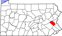 Location in the state of Pennsylvania |
|
 Pennsylvania's location in the U.S. |
|
| Statistics | |
| Founded | March 6, 1812 |
|---|---|
| Seat | Allentown |
| Largest city | Allentown |
| Area - Total - Land - Water |
349 sq mi (904 km²) 347 sq mi (899 km²) 2 sq mi (5 km²), 0.48% |
| Population - (2000) - Density |
312,090 901/sq mi (348/km²) |
| Website: www.lehighcounty.org | |
Lehigh County is a county located in the U.S. state of Pennsylvania. It was formed in 1812 from parts of Northampton County. As of 2000, the population of the county is 312,090. Its county seat is Allentown[1].
Lehigh County is named after the Lehigh River (whose name is derived from the Delaware Indian term Lechauweki or Lechauwekink, meaning "where there are forks") [2], which runs through the county's two largest cities, Allentown and Bethlehem. It is located in the Lehigh Valley region of Pennsylvania, in the eastern part of the state.
Contents |
Geography
Topography
According to the U.S. Census Bureau, the county has a total area of 348 square miles (902 km²), of which, 347 square miles (898 km²) of it is land and 2 square miles (4 km²) of it (0.48%) is water.
The county is located within the Lehigh Valley, a geographic region bounded by Blue Mountain, a ridge of the Appalachian mountain range, which varies from 1,000 to 1,600 feet (490 m) in height in the north of the county, and South Mountain, a ridge of 500 to 1,000 feet (300 m) in height in the south of the county.
Adjacent counties are Carbon County to the north; Northampton County to the northeast and east; Bucks County to the southeast; Montgomery County to the south; and Berks County and Schuylkill County to the west.
 |
Schuylkill County | Carbon County | Northampton County |
|
|||
| Berks County | Northampton County | ||||||
| Berks County | Montgomery County | Bucks County |
Climate
Most of the county's climate is considered to fall in the humid continental climate zone. Summers are typically hot and muggy, fall and spring are generally mild, and winter is cold. Precipitation is almost uniformly distributed throughout the year.
For the city of Allentown, January lows average −6 °C (21.2 °F) and highs average 1.3 °C (34.3 °F). The lowest officially recorded temperature was −26.7 °C (−16 °F) in 1912 . July lows average 17.6 °C (63.7 °F) and highs average 29.2 °C (84.6 °F), with an average relative humidity (morning) of 82%. The highest temperature on record was 40.6 °C (105.1 °F) in 1966 . Early fall and mid winter are generally driest, with October being the driest month with only 74.7 mm of average precipitation.[3]
Snowfall is variable, with some winters bringing light snow and others bringing numerous significant snowstorms. Average snowfall is 82.3 centimetres (32.4 in) per year,[4] with the months of January and February receiving the highest at just over 22.86 centimetres (9.00 in) each. Rainfall is generally spread throughout the year, with eight to twelve wet days per month,[5] at an average annual rate of 110.54 centimetres (43.52 in).[6]
| Month | Jan | Feb | Mar | Apr | May | Jun | Jul | Aug | Sep | Oct | Nov | Dec | Year |
|---|---|---|---|---|---|---|---|---|---|---|---|---|---|
| Avg high temperature °F (°C) | 35 (1) |
38 (3) |
48 (8) |
61 (16) |
71 (21) |
80 (26) |
85 (29) |
82 (27) |
75 (23) |
64 (17) |
52 (11) |
40 (4) |
(16) |
| Avg low temperature °F (°C) | 20 (-6) |
21 (-6) |
29 (-1) |
39 (3) |
49 (9) |
59 (15) |
64 (17) |
62 (16) |
54 (12) |
43 (6) |
34 (1) |
24 (-4) |
(5) |
| Precipitation in. (cm) | 3.2 (8) |
2.9 (7) |
3.6 (9) |
3.7 (9) |
4.1 (10) |
3.5 (8) |
4.3 (10) |
4.3 (10) |
3.9 (9) |
3.0 (7) |
3.8 (9) |
3.6 (9) |
(112) |
| Source: Weatherbase | |||||||||||||
Demographics
As of the census[7] of 2000, there were 312,090 people, 121,906 households, and 82,164 families residing in the county. The population density was 900 people per square mile (348/km²). There were 128,910 housing units at an average density of 372 per square mile (144/km²). The racial makeup of the county was 87.02% White, 3.56% Black or African American, 0.18% Native American, 2.10% Asian, 0.04% Pacific Islander, 5.28% from other races, and 1.83% from two or more races. 10.22% of the population were Hispanic or Latino of any race. 27.1% were of German, 7.9% Italian, 7.7% Irish, 6.2% Pennsylvania German and 5.6% American ancestry according to Census 2000. 85.0% spoke English, 8.4% Spanish and 1.2% Arabic as their first language.
There were 121,906 households out of which 30.60% had children under the age of 18 living with them, 53.00% were married couples living together, 10.50% had a female householder with no husband present, and 32.60% were non-families. 27.10% of all households were made up of individuals and 11.20% had someone living alone who was 65 years of age or older. The average household size was 2.48 and the average family size was 3.02.
In the county, the population was spread out with 23.90% under the age of 18, 8.10% from 18 to 24, 29.20% from 25 to 44, 23.00% from 45 to 64, and 15.80% who were 65 years of age or older. The median age was 38 years. For every 100 females there were 93.20 males. For every 100 females age 18 and over, there were 89.60 males.
Politics
As of April 2008, there are 210,656 registered voters in Lehigh County [1].
- Democratic: 101,763 (48.30%)
- Republican: 76,871 (36.49%)
- Other Parties: 32,022 (15.20%)
Lehigh County and neighboring Northampton County are part of Pennsylvania's 15th Congressional district. Despite the advantage in Democratic registration in the district, voters elected Republicans Charlie Dent in 2004 and 2006 and, previously, Pat Toomey in 1998, 2000, and 2002 to Congress. In 2004, however, the county did narrowly vote for John Kerry over George W. Bush for President, and in 2008 the county gave Barack Obama a victory of more than 15 points over John McCain, 57.1% to 41.5%.[8] The 15th Congressional district is generally considered one of the most contentious "swing districts" nationally, with neither Republicans nor Democrats winning the district consistently.
Famous people from Lehigh County
Lehigh County is the birthplace of several famous Americans, including:
- Chuck Bednarik, former professional football player, Philadelphia Eagles, and member of Pro Football Hall of Fame.
- Stephen Vincent Benét, author.
- Michaela Conlin, stage and television actress, Bones.
- H.D., writer.
- Don Cunningham, politician.
- Charlie Dent, Member of Congress.
- Peter Gruner, professional wrestler.
- Lee Iacocca, former chairman of Chrysler Corporation.
- Keith Jarrett, jazz musician.
- Michael Johns, health care executive and former White House speechwriter.
- Carson Kressley, fashion consultant on Bravo's Queer Eye for the Straight Guy.
- Matt Millen, former professional football player, Oakland Raiders, San Francisco 49ers and Washington Redskins, and former President and General Manager, Detroit Lions.
- Andre Reed, former professional football player, Buffalo Bills and Washington Redskins.
- Amanda Seyfried, model and actress, The CW's Veronica Mars and HBO's Big Love.
- Curt Simmons, former professional baseball player, California Angels, Chicago Cubs, Philadelphia Phillies and St. Louis Cardinals.
- Dana Snyder, voice actor, Cartoon Network's Aqua Teen Hunger Force
- Christine Taylor, actress and wife of actor Ben Stiller.
- Lauren Weisberger, author of The Devil Wears Prada.
Municipalities
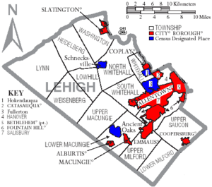
Under Pennsylvania law, there are four types of incorporated municipalities: cities, boroughs, townships, and, in at most two cases, towns. The following cities, boroughs and townships are located in Lehigh County:
Cities
Lehigh County includes west Bethlehem, while the remainder of the city is located in Northampton County.
Boroughs
|
|
Townships
|
|
|
Census-designated places
Census-designated places are geographical areas designated by the U.S. Census Bureau for the purposes of compiling demographic data. They are not actual jurisdictions under Pennsylvania law. Other unincorporated communities, such as villages, may be listed here as well.
|
Notable Villages
|
|
|
|
Education
4-Year Colleges and Universities
- Cedar Crest College, Allentown
- DeSales University, Center Valley
- Muhlenberg College, Allentown
- Penn State Lehigh Valley, Fogelsville
2-Year Colleges and Technical Institutes
- Baum School of Art, Allentown
- Lehigh Carbon Community College - Main Campus, Schnecksville, and Donley Center, Allentown
- Lehigh Valley College, Center Valley
- Lincoln Technical Institute, Allentown
Public school districts and schools

- Allentown School District
- William Allen High School, Allentown
- Louis E. Dieruff High School, Allentown
- Bethlehem Area School District
- Freedom High School, Bethlehem
- Liberty High School, Bethlehem.
- Catasauqua Area School District
- East Penn School District
- Emmaus High School, Emmaus
- Eyer Middle School, Macungie
- Lower Macungie Middle School, Macungie
- Northern Lehigh School District
- Northern Lehigh High School, Slatington
- Northwestern Lehigh School District
- Northwestern Lehigh High School, New Tripoli
- Parkland School District
- Parkland High School, South Whitehall Township
- Salisbury Township School District
- Salisbury High School, Salisbury Township
- Southern Lehigh School District
- Southern Lehigh High School, Center Valley
- Whitehall-Coplay School District
- Whitehall High School, Whitehall Township
Non-public high schools and charter schools
- Allentown Central Catholic High School, Allentown
- Lehigh Career and Technical Institute, Schnecksville
- Lehigh Valley Christian High School, Allentown
- Roberto Clemente Charter School, Allentown
- Salem Christian School, Macungie
Transportation
Air transportation
Air transport to and from Lehigh County is available through Lehigh Valley International Airport (IATA: ABE, ICAO: KABE).
Bus transportation
Public bus service in Lehigh County is available through the Lehigh and Northampton Transportation Authority, known as LANTA.
Road transportation
Interstates
- I-78
- I-476 -Northeast Extension of the Pennsylvania Turnpike
US Highway System
- Route 22
- Route 222
Pennsylvania Highway System
- Route 29 South
- Route 100
- Route 143
- Route 145
- Route 309
- Route 329
- Route 378
- Route 873
- Route 987
Other roads
- Cedar Crest Boulevard
Media
The Lehigh County is part of the Philadelphia broadcast media market, though numerous New York City radio and television stations also are available in Allentown and its suburbs. Lehigh County-based media include The Morning Call, a daily newspaper in Allentown, and two Allentown-based television stations: WLVT Channel 39 (a PBS affiliate) and WFMZ Channel 69 (an unaffiliated, independent television station). The four major Philadelphia-based network stations serving Lehigh County include: KYW-TV (CBS), WCAU (NBC), WPVI (ABC) and WTXF (Fox).
Lehigh County-area radio stations include WAEB-AM, a news, talk and sports station (in Allentown), WAEB-FM (known as B104), a Top 40 music station (in Allentown), WZZO, a hard rock music station (in Whitehall Township), and others. Some major New York City stations and every major Philadelphia station also can be heard in the county.
References
- ↑ "Find a County". National Association of Counties. Retrieved on 2008-01-31.
- ↑ Roberts, Charles R. (1936). "Place Names of Lehigh County and Their Origin". Proceedings: Lehigh County Historical Society (Lehigh County Historical Society).
- ↑ "Normal Monthly Precipitation, Inches". Retrieved on 2006-11-04.
- ↑ "Snowfall - Average Total In Inches". Retrieved on 2006-11-04.
- ↑ "Average Days of Precipitation, .01 cm or more". Retrieved on 2006-11-04.
- ↑ "Average Monthly Precipitation". Retrieved on 2006-11-04.
- ↑ "American FactFinder". United States Census Bureau. Retrieved on 2008-01-31.
- ↑ "Election Results 2008: President Map". New York Times (2008-11-21). Retrieved on 2008-11-23.
External links
- Lehigh County Government Official Web Site.
- "Living in the Greater Lehigh Valley," by The Allentown Morning Call.
|
||||||||||||||||||||||||||
|