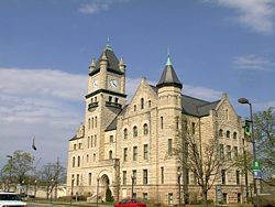
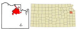
Lawrence, Kansas
| City of Lawrence | |||
 |
|||
|
|||
| Nickname(s): Larryville | |||
| Motto: From Ashes to Immortality | |||
 |
|||
| Coordinates: | |||
| Country | United States | ||
|---|---|---|---|
| State | Kansas | ||
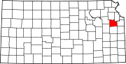
| County | Douglas | ||
| Founded | 1854 | ||
| Government | |||
| - Mayor | Sue Hack | ||
| - City manager | Dave Corliss | ||
| Area | |||
| - City | 28.7 sq mi (74.3 km²) | ||
| - Land | 28.1 sq mi (72.8 km²) | ||
| - Water | 0.6 sq mi (1.5 km²) | ||
| Elevation | 840 ft (256 m) | ||
| Population (2006) | |||
| - City | 88,605 | ||
| - Density | 3,153.2/sq mi (1,217.1/km²) | ||
| - Metro | 112,123 | ||
| Time zone | CST (UTC-6) | ||
| - Summer (DST) | CDT (UTC-5) | ||
| Area code(s) | 785 | ||
| FIPS code | 20-38900[1] | ||
| GNIS feature ID | 0479145[2] | ||
| Website: www.lawrenceks.org | |||
Lawrence is the sixth largest city in the U.S. State of Kansas and the county seat of Douglas County. Located in northeastern Kansas, Lawrence is the anchor city of the Lawrence, Kansas Metropolitan Area which encompasses all of Douglas County. Located forty-one miles west of Kansas City, Missouri, it is situated along the banks of the Kansas and Wakarusa Rivers. In 2007, the city had an estimated population of 89,852.[3] Lawrence is a college town and is the home to the University of Kansas and Haskell Indian Nations University.
Contents |
History
Lawrence was founded in 1854 for the New England Emigrant Aid Company by Charles Robinson, who later served as governor of Kansas. The city was named after Amos Adams Lawrence, a prominent politician and antislavery partisan and the son of famed philanthropist Amos Lawrence.
In the Bleeding Kansas era, Lawrence was a center of anti-slavery sentiment. On May 21, 1856, a pro-slavery posse led by Sheriff Samuel J. Jones burned the Free-State Hotel, destroyed the equipment of two anti-slavery newspapers, and looted several other businesses in an attack known as the sack of Lawrence; one man was killed, struck dead by a stone falling from the burning hotel. Abolitionist John Brown's nearby Pottawatomie Massacre is believed to have been a reaction to this event. On August 21, 1863, during the American Civil War, Confederate guerrillas led by William Quantrill burned most of the houses and commercial buildings in Lawrence and killed 150 to 200 of the men they found in the Lawrence Massacre. Of historical importance is KU's Pioneer Cemetery, perhaps best known for being the final resting place of Thomas Barber, a free-state settler, and Elmer McCollum, KU alumnus who is credited with discovering Vitamin A. James Naismith, the inventor of basketball, is buried in East Lawrence in Memorial Park Cemetery.
The University of Kansas was founded in Lawrence in 1865 by the citizens of Lawrence under a charter granted by the Kansas Legislature, with the donation of 40 acres (160,000 m²) of land on Mount Oread by former Kansas Governor Charles Robinson and his wife, Sara, and a small monetary gift from Amos Adams Lawrence. As a college town, Lawrence is known for its liberal philosophy and distinctive culture.
Lawrence also holds the distinctions of having been the site of operation for the state's first railroad in 1871 and the city where the state's first telephone was installed in 1877. In 1989, when the Free State Brewing Co. opened in Lawrence, it was the first legal brewery in Kansas in more than 100 years. The restaurant is in a renovated inter-trolley station in downtown Lawrence. The city is home to the state's only hydro-electric plant.
In the early 1980s Lawrence grabbed national and later world attention because of the television movie The Day After. The TV movie first appeared on ABC but was later shown in movie theaters around the world. The movie depicted what would happen to average Americans, particularly those living in Lawrence and surrounding communities, if the United States was destroyed in a nuclear war. The movie was filmed in Lawrence with help from many people in the community.
Geography
Lawrence is situated at (38.959902, -95.253199)[4]. This is about 41 miles (66 km) west of Kansas City, and about 20 miles (30 km) east of Topeka. According to the United States Census Bureau, the city has a total area of 28.7 square miles (74.3 km²), of which, 28.1 square miles (72.8 km²) of it is land and 0.6 square miles (1.5 km²) is water, including Potter Lake on the KU campus. The total area is 2.06% water.
Older versions of Google Earth, software that allows the user to "fly" over the surface of the earth, mapped with satellite photography and topographical data, has a default position that, when the program launches, is centered exactly on the city of Lawrence (specifically on Meadowbrook Apartments, lying between Compton Square and Regency Place). This may be verified by running the software and zooming in from the default start position without rotating the virtual globe at all. This location was set by Brian McClendon, a 1986 graduate of the University of Kansas and director of engineering for Google Earth.[5] Newer versions of the program center on Lawrence on the initial run, but center on the user's own location on subsequent launches.
Lawrence's Mount Oread is named after Oread Seminary in Worcester, which was founded by the organization that sent the city's first settlers.[6]
Climate
Over the course of a year, temperatures range from an average low of almost 20 °F (−7 °C) in January to an average high above 90 °F (32 °C) in July. The high temperature reaches 90 °F (32 °C) an average of 49 days a year and reaches 100 °F (38 °C) an average of five days a year. The minimum temperature falls below the freezing point (32°F) an average of 96 days a year. Typically the first fall freeze occurs between mid-October and the second week of November, and the last spring freeze occurs between the last week of March and the third week of April.
The area receives nearly 40 inches (1,000 mm) of precipitation during an average year with the largest share being received in May and June; the April-to–June period averages 32 days of measurable precipitation. During a typical year the total amount of precipitation may be anywhere from 27 to 54 inches (1,400 mm). There are on average 100 days of measurable precipitation each year. Winter snowfall averages almost 18 inches, but the median is less than 10 inches (250 mm). Measurable snowfall occurs an average of 10 days a year with at least an inch of snow being received on six of those days. Snow depth of at least an inch occurs an average of 18 days a year.
| Month | Jan | Feb | Mar | Apr | May | Jun | Jul | Aug | Sep | Oct | Nov | Dec | Year |
|---|---|---|---|---|---|---|---|---|---|---|---|---|---|
| Temperatures (°F) | |||||||||||||
| Mean high | 39.2 | 45.6 | 57.2 | 67.6 | 76.6 | 85.3 | 90.6 | 89.4 | 81.3 | 70.1 | 54.2 | 42.4 | 66.6 |
| Mean low | 20.5 | 25.9 | 35.4 | 45.7 | 55.6 | 64.8 | 69.7 | 67.9 | 59.4 | 48.3 | 35.6 | 25.0 | 46.2 |
| Highest recorded | 72 (1967) |
82 (1972) |
90 (1946) |
94 (1989) |
98 (1956) |
107 (1980) |
111 (1954) |
107 (1984) |
108 (1947) |
98 (1939) |
84 (1980) |
76 (1939) |
111 (1954) |
| Lowest recorded | −18 (1947) |
−11 (1996) |
−7 (1978) |
13 (1975) |
30 (1944) |
44 (1945) |
51 (1972) |
42 (1956) |
31 (1942) |
20 (1993) |
2 (1986) |
−21 (1989) |
−21 (1989) |
| Precipitation (inches) | |||||||||||||
| Median | 1.14 | 1.15 | 2.33 | 3.03 | 5.54 | 4.41 | 2.70 | 3.09 | 3.62 | 2.90 | 2.32 | 1.56 | 37.69 |
| Mean number of days | 6.4 | 6.2 | 8.8 | 10.3 | 12.0 | 9.5 | 8.6 | 8.4 | 8.5 | 7.7 | 7.5 | 6.1 | 100.0 |
| Highest monthly | 3.49 (1979) |
2.71 (1997) |
10.54 (1973) |
8.93 (1999) |
11.54 (1995) |
14.35 (1977) |
18.30 (1993) |
10.94 (1996) |
12.85 (1973) |
10.11 (1998) |
6.21 (1998) |
4.77 (1971) |
|
| Snowfall (inches) | |||||||||||||
| Median | 3.8 | 3.8 | 0.0 | 0.0 | 0.0 | 0.0 | 0.0 | 0.0 | 0.0 | 0.0 | 0.3 | 1.7 | 9.6 |
| Mean number of days | 2.9 | 2.6 | 0.9 | 0.3 | 0.0 | 0.0 | 0.0 | 0.0 | 0.0 | 0.1 | 0.9 | 2.4 | 10.1 |
| Highest monthly | 21.9 (1985) |
17.5 (1978) |
7.5 (1975) |
4.5 (1983) |
0.0 | 0.0 | 0.0 | 0.0 | 0.0 | 7.0 (1996) |
8.0 (1975) |
10.6 (1973) |
|
| Notes: Temperatures are in degrees Fahrenheit. Precipitation includes rain and melted snow or sleet in inches; median values are provided for precipitation and snowfall because mean averages may be misleading. Mean and median values are for the 30-year period 1971–2000; temperature extremes are for the station's period of record (1939–2001). The station is located in Lawrence at 38°58′N 95°16′W, elevation 980 feet (300 m). | |||||||||||||
Demographics
| Historical populations | |||
|---|---|---|---|
| Census | Pop. | %± | |
| 1860 | 1,645 |
|
|
| 1870 | 8,320 | 405.8% | |
| 1880 | 8,510 | 2.3% | |
| 1890 | 9,997 | 17.5% | |
| 1900 | 10,862 | 8.7% | |
| 1910 | 12,374 | 13.9% | |
| 1920 | 12,456 | 0.7% | |
| 1930 | 13,726 | 10.2% | |
| 1940 | 14,390 | 4.8% | |
| 1950 | 23,351 | 62.3% | |
| 1960 | 32,858 | 40.7% | |
| 1970 | 45,698 | 39.1% | |
| 1980 | 52,738 | 15.4% | |
| 1990 | 65,608 | 24.4% | |
| 2000 | 80,098 | 22.1% | |
As of the census[1] of 2000, there were 80,098 people, 31,388 households, and 15,725 families residing in the city. The population density was 2,849.4 people per square mile (1,100.2/km²). There were 32,761 housing units at an average density of 1,165.4/sq mi (450.0/km²). The racial makeup of the city was 83.80% White, 5.09% African American, 2.93% Native American, 3.78% Asian, 0.07% Pacific Islander, 1.36% from other races, and 2.97% from two or more races. Hispanic or Latino of any race were 3.65% of the population. 23.8% were of German, 10.6% English, 10.1% Irish and 7.1% American ancestry according to Census 2000. 91.0% spoke English, 2.9% Spanish and 1.0% Chinese or Mandarin as their first language.
Of the 31,388 households, 25.1% included children under the age of 18, 38.0% were married couples living together, 8.7% had a female householder with no husband present, and 49.9% were non-families. 30.6% of all households were made up of individuals and 5.6% had someone living alone who was 65 years of age or older. The average household size was 2.30 and the average family size was 2.93.
In the city the population was spread out with 18.6% under the age of 18, 30.7% from 18 to 24, 28.5% from 25 to 44, 15.1% from 45 to 64, and 7.2% who were 65 years of age or older. The median age was 25 years. For every 100 females there were 98.8 males. For every 100 females age 18 and over, there were 98.2 males.
The median income for a household in the city was $34,669, and the median income for a family was $51,545. Males had a median income of $33,481 versus $27,436 for females. The per capita income for the city was $19,378. About 7.3% of families and 18.9% of the population were below the poverty line, including 10.6% of those under age 18 and 7.7% of those age 65 or over.
Politics and culture

While Kansas is a heavily Republican state, Lawrence is reliably Democratic.[7] Douglas County, where Lawrence is situated, was one of only two counties in Kansas whose majority voted for John Kerry in the 2004 presidential election and one of only three that voted for Obama in the 2008 election. Douglas County has supported the Democratic candidate the past five presidential elections.[8][9][10][11][12] Currently, Lawrence is served by both the 2nd and 3rd U.S. Congressional Districts of Kansas. Before reapportionment in 2002, Lawrence sat entirely within the third district. Douglas County was the only county in the state to reject the amendment to the Kansas Constitution prohibiting both gay marriage and civil unions in April 2005. (The vote against the amendment was primarily in the city of Lawrence; outside the city, the amendment carried in the rest of Douglas County.) Lawrence has an active chapter of the Kansas Equality Coalition, which persuaded the city commission to approve a domestic partner registry on May 22, 2007. The registry, which took effect Aug. 1, provides unmarried couples -- both same-sex and other-sex -- some recognition by the city for legal purposes. At the request of the city commission, the Kansas Attorney General reviewed the ordinance before it was enacted; he concluded that the ordinance did not violate the state constitutional ban on same-sex marriage, but he also recommended that the registry be available only to Lawrence residents.[13]
Lawrence also features many characteristics of a college town, such as a radical library and infoshop, two microbreweries, and a half dozen locally owned coffeehouses. The city is known for a thriving music and art scene; Rolling Stone named Lawrence one of the "best lil' college towns" in the country in its August 11, 2005, issue. They had previously named the local commercial radio station, KLZR 105.9 FM, as one of a top ten "Stations that Don't Suck" in 1998. The station, which was independently owned at that time, was soon after sold to corporate buyers and the format changed to Top 40. KJHK 90.7 FM, the University of Kansas's student-run radio station, is a staple of the local music scene. It won a CMJ award in 2006 for "most improved station" and was nominated for a Plug Award for best college radio station in 2007.The New York Times said Lawrence had "the most vital music scene between Chicago and Denver" in a travel column on February 25, 2005. Locally owned bar and music venue "The Replay Lounge" was named one of GQ magazines top 25 bars/venues in the country in 2007. The Replay is known to locals for pinball machines, Pabst Blue Ribbon beer, music and a heated outside smoking area that is one of the largest in the city. (The city code of Lawrence bans smoking inside all public places.)
The Wakarusa Music and Camping Festival is a four-day-long weekend music festival held annually in early June just outside Lawrence, at Clinton State Park. After its inception in 2004, the festival had grown dramatically by 2006, with almost 60,000 tickets sold, while developing a nationwide following that accounted for 80% of ticket sales. The festival is known for an eclectic mix of music, featuring artists like The Flaming Lips, Wilco, STS9, Medeski, Martin and Wood, Neko Case, and Widespread Panic, to name a few. The event is kept smaller than other festivals such as Bonnaroo by an agreement with the state.[14] Activities other than music include disc golf, yoga, hiking, and swimming in Clinton Lake. The festival is in risk of being discontinued due to a dispute between the organizers and the Kansas Department of Wildlife and Parks over limiting attendees and over rent payment.[15]
In recent years the North vs. South Music Festival has become a staple of the music scene. Held each August to coincide with the anniversary of Quantrill's Raid, North vs. South is billed as a friendly reenactment of that famous Civil War battle and features over four dozen independent rock bands hailing mostly from Minneapolis, Minnesota, and Austin, Texas.
Each May, the city hosts the "Art in the Park" festival in South Park, a greenspace in downtown Lawrence.
Lawrence's culture isn't just political activism and the arts; the town is famous for the University of Kansas's athletic teams as well. The perennially highly-ranked (and 1952, 1988, 2008 NCAA Champions) Kansas Jayhawks basketball team is closely followed by many residents during the winter, and the school's football team has reached bowl eligibility in four of the past five years, including a 12-1 record in the 2007 season (the best in school history) and a victory in the Orange Bowl. The city honored the university's mascot, the Jayhawk, in 2003 when 30 statues of Jayhawks were commissioned by the Lawrence Convention and Visitors Bureau; these can be seen throughout the city as part of an art installation called "Jayhawks on Parade."
Education
Post-Secondary
The University of Kansas is the largest public university in the state, with a total enrollment of just under 30,000 (including the Medical Center). It has over 170 fields of study and the nationally known Kansas Jayhawks athletics programs. Haskell Indian Nations University offers free tuition to members of registered Native American tribes. It has an average enrollment of more than 1,000 students representing all 50 states and 150 tribes. Haskell is the home of the American Indian Athletic Hall of Fame and the Haskell Cultural Center. Pinnacle Career Institute offers students career training programs in several different fields.
K-12 schools

The Unified School District 497 includes sixteen public grade schools, four junior high schools: Central, West, South, and Southwest, and two high schools: Lawrence High School and Lawrence Free State High School.[16] The athletic teams of the former are nicknamed the Chesty Lions, and those of the latter are the Firebirds. Both schools are Class 6A in enrollment size, and Lawrence High School leads the State of Kansas in most state championships won, with 103 championships. The Lawrence High School football team also leads the nation with most undefeated seasons at 31, though all of these occurred before Free State High School came into existence. Private high schools include Bishop Seabury Academy, which is affiliated with the Episcopal Church, and the non-denominational Veritas Christian School. There is also St. John Catholic School, which teaches grades 1 through 6 and is funded by the Catholic communities of Lawrence and Corpus Christi Catholic School. Raintree Montessori School is a secular private school which teaches preschool through grade 6. The Prairie Moon School is a Waldorf school near Lawrence.
Transportation
Passenger train service is provided by Amtrak at the Lawrence Amtrak station.

Two public bus systems operate in the city; "The T" is operated by the city and "KU On Wheels" is operated by the University of Kansas.[17][18] As of fall 2008, both bus systems are free to KU students.[19]
Sites of interest
Downtown Lawrence, in particular Massachusetts Street, has a lively atmosphere and is filled with restaurants, bars, galleries, shops and music venues.

The Bowersock Dam provides hydropower to riverfront businesses like the Lawrence Journal-World. The city is also home to the Gaslight Tavern.

The University of Kansas campus is home to many museums, including the KU Natural History Museum and the Spencer Museum of Art. The Robert J. Dole Institute of Politics houses various artifacts from the life of the former Kansas Senator. Another site of interest is the Lawrence Arts Center. It has daytime activities, organized plays and acts, and an art gallery filled with artwork created by the townspeople.
Sister cities
Lawrence has two sister cities through Sister Cities International:
Lawrence has one sister city through "US-El Salvador Sister Cities":
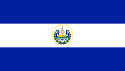 El Papaturro, El Salvador
Popular culture
- In the CW television series, Supernatural, Lawrence is the hometown of the two main characters, the brothers Sam and Dean Winchester, their parents, and their grandparents. Several scenes in the pilot, and three later episodes - Season 1, Episode 9 "Home", Season 2, Episode 20 "What Is and What Should Never Be", and Season 4, Episode 3, "In the Beginning", are set in Lawrence (though all were filmed in British Columbia, Canada).
- In the 1983 TV movie The Day After, Lawrence was ravaged by fallout from detonations of nearby Soviet nuclear bombs, including one which destroyed Kansas City, Missouri. The TV movie was shot on location in and around Lawrence, and many locals were used to play small roles or perform as extras.
- Lawrence was also destroyed in the 2006 TV Series Jericho: In the seventh episode of the series, it is mentioned that Lawrence was destroyed by a nuclear blast. Some exterior shots for the CBS series Jericho were filmed in Lawrence. [2]
- Colleen McMurphy, a character in the TV series China Beach, hailed from Lawrence.
- A scene from Where Pigeons Go To Die, a movie directed by Michael Landon, was shot in the 1300 block of Massachusetts Street.
- The beginning and ending chapters of Peter Cameron's novel The City of Your Final Destination take place in Lawrence, where the protagonist is a graduate student at the University of Kansas. The novel depicts Lawrence in a way more closely approaching reality than it does Uruguay, where most of the novel's action takes place.
- In the movie About Schmidt, Jack Nicholson's character, Warren R. Schmidt, visited his alma mater, the University of Kansas (however, the scene itself was filmed at the University of Nebraska.
- The 1999 movie, Ride with the Devil includes a scene based on William Quantrill's infamous 1863 massacre in Lawrence, Kansas.
- From 1947 until 1981, Lawrence was the location of the Centron Corporation, one of the major industrial and educational film production companies in the United States at the time. The studio was founded by two University of Kansas graduates and employed university students and faculty members as advisers and actors. Also, many talented local and area filmmakers were given their first chances to make movies with Centron, and some stayed for decades. Others went on to successful careers in Hollywood. One of these local residents, Herk Harvey, was employed by Centron as a director for 35 years and in the middle of his tenure there he made a full-length theatrical film, Carnival of Souls, a horror cult film shot mostly in Lawrence and released in 1962. The Centron Corporation soundstage and residing building is now called Oldfather Studios and houses the University of Kansas film program.
- Lawrence and the Jayhawks have been spotted several times on Saturday Night Live, including a sketch with Jack Black set at The Wheel (a popular student bar). [20] These appearances are the handiwork of Jason Sudeikis, SNL writer and performer, an Overland Park, KS native.
- Lawrence was the setting of an episode of NBC television show Heroes.[21]
Media outlets
Television
- KUJH-LP 14, independent station, owned by University of Kansas
Radio
- KANU 91.5 FM, National Public Radio station, owned and operated by the University of Kansas
- KJHK 90.7 FM, college radio, owned and operated by the University of Kansas
- KLZR 105.9 FM, commercial radio station, owned by Great Plains Media
- KLWN 1320 AM, commercial radio station, owned by Great Plains Media
- KMXN 92.9 FM, commercial radio station, owned by Great Plains Media
- The University Daily Kansan, the independent student newspaper of the University of Kansas.
- The Lawrence Journal-World, the local daily newspaper.
- The Lawrencian, monthly alternative newspaper
- Kaw Valley Senior Monthly, monthly newspaper for seniors
See also
- List of people from Lawrence, Kansas
References
- ↑ 1.0 1.1 "American FactFinder". United States Census Bureau. Retrieved on 2008-01-31.
- ↑ "US Board on Geographic Names". United States Geological Survey (2007-10-25). Retrieved on 2008-01-31.
- ↑ http://www.census.gov/popest/cities/tables/SUB-EST2007-04-20.xls
- ↑ "US Gazetteer files: 2000 and 1990". United States Census Bureau (2005-05-03). Retrieved on 2008-01-31.
- ↑ [1]
- ↑ Mount Oread’s name precedes that of city, Lawrence Journal-World, 2004-09-13. Accessed 2007-09-26.
- ↑ Two Kansas counties stand alone...
- ↑ 2004 Presidential Election Results
- ↑ 2000 Presidential Election Results
- ↑ 1996 Presidential Election Results
- ↑ 1992 Presidential Election Results
- ↑ 2008 Presidential Election Results
- ↑ Lawhorn, Chad. (6 April 2007) A.G. approves Lawrence domestic partnership registry. Lawrence Journal-World. Retrieved on 2008-10-19.
- ↑ "Wakarusa Officials Reflect On Event", Lawrence Journal-World (2005-06-24). Retrieved on 2007-04-08.
- ↑ Lawhorn, Chad (10 August 2008). "Wakarusa Fest may not play on". Lawrence Journal-World. Retrieved on 2008-10-19.
- ↑ http://www.usd497.org/
- ↑ http://www.lawrencetransit.org "The T" Lawrence City Bus System
- ↑ http://www.kuonwheels.ku.edu/ "KU On Wheels" University Bus System
- ↑ http://www.kuonwheels.ku.edu/buspass.shtml?expandable=0 "KU On Wheels" Fares
- ↑ Saturday Night fever
- ↑ Lawrence makes an appearance on Heroes
External links
- Lawrence wiki
- The Lawrence Townie Insider's Guide
- City of Lawrence
- Lawrence Visitors Bureau
- Lawrence.com
- Lawrence Chamber of Commerce
- Lawrence, Kansas is at coordinates
|
|||||||||||||||||
|